Location
Latitude: |
38-13-40.7425N (38.227984) |
Longitude: |
085-39-49.4966W (-85.663749) |
Elevation: |
545.6 feet MSL (166 m MSL) |
Magnetic Variation: |
5.1 W (as of April 2024 from WMM2020 model) |
Time Zone: |
UTC -5.0 (Standard Time) UTC -4.0 (Daylight Savings Time) |
From City: |
05 N.M. SE of Louisville, Kentucky |
Found On: |
St Louis Chart |
FAA Region: |
ASO |
Contacts
Manager: |
Publicly owned: |
| MICHAEL THOMPSON 3345 ROGER SCHUPP STREET LOUISVILLE, KY 40205 502-458-1475 |
REGIONAL AIRPORT AUTH P O BOX 9129 LOUISVILLE, KY 40209-0129 502-368-6524 |
Operations
Airport Status: |
Operational |
Facility Use: |
Public |
Type: |
Airport |
Activation Date: |
04/1940 |
Control tower: |
Yes |
Attendance (Months/Days/Hours): |
Months/Days/Hours ALL/ALL/0700-2200 |
Boundary ARTCC: |
ZID (Indianapolis) |
Responsible ARTCC: |
ZID (Indianapolis) |
Lighting Schedule: |
SEE RMK |
Segmented Circle Indicator: |
No |
Traffic Pattern Altitude (MSL): |
1546 feet (471 m) |
NOTAMs Facility: |
LOU |
NOTAM-D Service: |
Yes |
International Airport of Entry: |
No |
Customs Landing Rights: |
No |
Military Landing Rights: |
Yes |
Civil/Military Joint Use: |
No |
Based Aircraft
| Single Engine: | 195 |
| Multi Engine: | 29 |
| Jet Engine: | 6 |
| GA Helicopters: | 5 |
Annual Operations (as of 06/20/2022)
| Total Operations: | 97874 | |
| Air Taxi: | 6383 | 6.5% |
| GA Local: | 46425 | 47.4% |
| GA Itinerant: | 43999 | 45.0% |
| Military Aircraft: | 1067 | 1.1% |
Communications
| CTAF: | 119.500 |
| Unicom: | 122.950 |
| Tower: | BOWMAN 119.5 257.625 Hrs: 0700-2200 |
| Clearance Del.: | 118.9 |
| Ground: | 121.8 |
| Approach: | LOUISVILLE |
| Departure: | LOUISVILLE |
| ATIS: | 124.15 Hrs: 24 |
| ASOS: | 118.275 (502-473-0693) |
| VFR ADZY: | 119.5 |
Fixed Based Operators (FBOs) & Fuel
(Click on a business for detail)
Please help us keep this information up to date. This is a FREE SERVICE just like everything else on Airport Guide! If you see that a business needs to be added, modified, or deleted please fill out our Update Form.
To add, modify, or delete a business click here.
Please help us keep this information up to date. This is a FREE SERVICE just like everything else on Airport Guide! If you see that a business needs to be added, modified, or deleted please fill out our Update Form.
Area Code: 502 |
| Business Name | Frequency | Phone | Fuel Grade |
|---|---|---|---|
| Cardinal Wings, Inc.
Update FBO info |
459-6184 | ||
| Central American Airways
Update FBO info |
Unicom 122.95 | 458-3211 | 100LL, Jet A |
| Louisville Aviation
Website Update FBO info |
502-905-8747 | ||
| Triangle Flying Service
Update FBO info |
Unicom 122.95, Arinc 130.775 | 452-1185 | 100LL, Jet A |
Flight Service Stations
| Primary | Alternate | |
| FSS on Field: | N | |
| FSS Name (ID): | Louisville(LOU) | |
| Frequency: | ||
| Toll Free Phone: | 1-800-WX-BRIEF |
Instrument Procedures / Charts
FAA Terminal Procedures valid from 0901Z 03/21/24 to 0901Z 04/18/24.
There are various types of charts available for an airport. They are listed in the Page Type column. Here is a legend for those types:
APD - Airport Diagram
DP - Departure Procedure Charts
HOT - Hot Spots
IAP - Instrument Approach Procedure Charts
MIN - Minimums
STAR - Standard Terminal Arrival Charts
| Page Type | Page Name | Volume | Action Since Last Cycle |
|---|---|---|---|
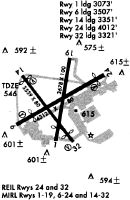
| APD | AIRPORT DIAGRAM | SE-1 | |
| HOT | HOT SPOT | SE-1 | |
| IAP | NDB RWY 33 | SE-1 | |
| IAP | RNAV (GPS) RWY 24 | SE-1 | |
| IAP | RNAV (GPS) RWY 33 | SE-1 | |
| MIN | ALTERNATE MINIMUMS | SE-1 | |
| MIN | TAKEOFF MINIMUMS | SE-1 | |
| STAR | CHERI FOUR | SE-1 | |
| STAR | DARBY EIGHT | SE-1 | |
| STAR | REDSTONE SIX | SE-1 |
Terminal Procedures are only available for airports in several countries with more being added all the time. If you are looking for a specific country's charts, please send an email to support(at)airportguide.com stating the country name. This will be used to prioritize the implementation.
Navigation Aids (Navaids) near LOU
| Dist (NM) | ID | Morse Code | Name | Type | Freq | True Hdg | Mag Hdg |
|---|---|---|---|---|---|---|---|
| 0.1 | BQM | _ . . . _ _ . _ _ _ | Bowman | DME | 112.2 | 341 | 346 |
| 4.2 | SDF | . . . _ . . . . _ . | Louisville Standifd | VOT | 111.00 | 235 | 240 |
| 5.2 | LK | . _ . . _ . _ | Laang | NDB | 414 | 163 | 168 |
| 8.5 | IIU | . . . . . . _ | Louisville | VORTAC | 114.80 | 151 | 156 |
| 15.2 | JV | . _ _ _ . . . _ | Catch | NDB | 331 | 346 | 351 |
| 21.7 | ABB | . _ _ . . . _ . . . | Nabb | VORTAC | 112.40 | 3 | 8 |
| 21.9 | GOI | _ _ . _ _ _ . . | Godman | NDB | 396 | 222 | 227 |
| 24.2 | FTK | . . _ . _ _ . _ | Fort Knox | VOR-DME | 109.60 | 217 | 222 |
| 24.4 | BRY | _ . . . . _ . _ . _ _ | Bardstown/Dcmsnd | NDB | 248 | 159 | 164 |
| 33.1 | GVR | _ _ . . . . _ . _ . | Hanover | DME | 114.65 | 15 | 20 |
| 34.0 | MYS | _ _ _ . _ _ . . . | Mystic | VOR | 108.20 | 234 | 239 |
| 35.7 | FFT | . . _ . . . _ . _ | Frankfort | VOR | 109.40 | 94 | 99 |
| 35.8 | EWO | . . _ _ _ _ _ | New Hope | VOR-DME | 113.95 | 180 | 185 |
| 40.9 | IKY | . . _ . _ _ . _ _ | Springfield | NDB | 429 | 150 | 155 |
| 41.0 | EQZ | . _ _ . _ _ _ . . | Captain | NDB | 308 | 339 | 344 |
| 49.5 | LE | . _ . . . | Blayd | NDB | 242 | 106 | 111 |
| 50.1 | TEL | _ . . _ . . | Tell City | NDB | 206 | 255 | 260 |
| 51.6 | BFR | _ . . . . . _ . . _ . | Bedford | NDB | 344 | 315 | 320 |
| 53.4 | TYC | _ _ . _ _ _ . _ . | Taylor County | NDB | 272 | 157 | 162 |
| 54.9 | GN | _ _ . _ . | Bridl | NDB | 340 | 96 | 102 |
Nearby Airports with Fuel
Notices to Airmen (NOTAMS)
Remarks
| A110-10 | COMPASS ROSE LCTD AT ADMIN BLDG NOT FOR COMPASS CALIBRATION USE. |
| A110-11 | 24 HR PPR FOR MIL ROTARY WING. |
| A110-12 | FOR CD WHEN ATCT CLSD, CTC SDF ATCT 502-375-7499. |
| A110-2 | STAGE 3 COMPLIANCE RQRD FOR TURBOJET; PPR FOR ACFT OVER 30000 LBS GWT - 502-368-6524. |
| A110-5 | TRNG OPS NA WHEN ATCT CLSD. |
| A110-6 | OBSTNS & TREES IN ALL APCH SFCS. |
| A110-7 | ADCUS FLT NOTIFICATION SVC AVBL. |
| A110-8 | BIRDS ON & INVOF ARPT DURG DALGT HR. |
| A16 | 502-472-6378 |
| A52-15 | 6 FT PATH & GOLF CARTS. |
| A57-06 | APCH RATIO 20:1 TO DTHR. |
| A57-15 | APCH RATIO 20:1 TO DTHR. |
| A57-24 | APCH RATIO 20:1 TO DTHR. |
| A57-33 | APCH RATIO 20:1 TO DTHR. |
| A58-06 | 8 FT FENCE 108 FT FM RWY END; 956 FT FM DTHR. ROAD 159 FT FM RWY END; 1007 FT FM DTHR. |
| A58-15 | +8 FT FENCE 188 FT FM RWY END; 394 FT FM DTHR. |
| A81-APT | ACTVT MIRL RWY 06/24 & 15/33 - CTAF. |
| E111 | EXISTED PRIOR TO 1959. |
Runways
Runway Summary
| Runways: | 06/24 15/33 |
| Longest Runway: | 06/24 is 4358 ft (1328 m) long |
| Runways with an Instrument Approach: |
LOU Airport Runway Details
| Runway 06/24 | 4358 ft x 75 ft (1328 m x 23 m) | |
| Runway Length Source: | 3RD PARTY SURVEY as of 12/20/2012 | |
| Surface: | Asphalt - Fair condition - No special surface treatment | |
| Runway Edge Lights: | Medium Intensity | |
Runway Weight Bearing Capacity (in thousands of pounds) |
||
| Single Wheel Landing Gear: | 30.0 | |
Runway 06 |
Runway 24 |
|
Elevation: |
544.4 | 530.9 |
Latitude: |
38-13-31.5308N | 38-13-53.3359N |
Longitude: |
085-40-10.0197W | 085-39-22.9164W |
|
Runway True Alignment: |
060 | 240 |
Glide Path Angle: |
3.5 degrees | 3.0 degrees |
Traffic Pattern: |
Left | Left |
Runway Markings Type: |
Nonprecision Instrument | Nonprecision Instrument |
Runway Markings Condition: |
Good | Good |
Object at End: |
TREE | TREE |
Object Height: |
10 | 17 |
Distance from End: |
204 | 388 |
Object Centerline Offset: |
76 ft. right of centerline | 80 ft. left of centerline |
Visual Glide Slope Indicators: |
2-Light PAPI On Left Side Of Runway | 2-Light PAPI On Left Side Of Runway |
REIL: |
Yes | |
Threshold Crossing Height: |
45 | 53 |
Threshold Elevation: |
544.7 | 533.9 |
Displaced Threshold: |
848 | 310 |
Threshold Latitude: |
38-13-35.7751N | 38-13-51.7853N |
Threshold Longitude: |
085-40-00.8529W | 085-39-26.2671W |
Declared Distances |
||
Take Off Run Avbl. (TORA): |
4047 | 3509 |
Take Off Distance Avbl. (TODA): |
4357 | 4357 |
Actual Stop Dist. Avbl. (ASDA): |
4316 | 4165 |
Landing Dist. Avbl. (LDA): |
3469 | 3856 |
| Runway 15/33 | 3580 ft x 75 ft (1091 m x 23 m) | |
| Runway Length Source: | 3RD PARTY SURVEY as of 12/20/2012 | |
| Surface: | Asphalt - Fair condition - No special surface treatment | |
| Runway Edge Lights: | Medium Intensity | |
Runway Weight Bearing Capacity (in thousands of pounds) |
||
| Single Wheel Landing Gear: | 30.0 | |
Runway 15 |
Runway 33 |
|
Elevation: |
538.7 | 518.8 |
Latitude: |
38-13-52.9232N | 38-13-24.4453N |
Longitude: |
085-40-06.4964W | 085-39-39.8701W |
|
Runway True Alignment: |
144 | 324 |
Glide Path Angle: |
3.5 degrees | 3.2 degrees |
Traffic Pattern: |
Left | Left |
Runway Markings Type: |
Nonprecision Instrument | Nonprecision Instrument |
Runway Markings Condition: |
Good | Good |
Object at End: |
OTHER | ROAD |
Object Height: |
7 | 8 |
Distance from End: |
262 | 289 |
Object Centerline Offset: |
76 ft. right of centerline | 80 ft. left of centerline |
Visual Glide Slope Indicators: |
2-Light PAPI On Left Side Of Runway | 2-Light PAPI On Left Side Of Runway |
REIL: |
Yes | |
Threshold Crossing Height: |
45 | 45 |
Threshold Elevation: |
538.5 | 526.9 |
Displaced Threshold: |
206 | 342 |
Threshold Latitude: |
38-13-51.2839N | 38-13-27.1621N |
Threshold Longitude: |
085-40-04.9640W | 085-39-42.4122W |
Declared Distances |
||
Take Off Run Avbl. (TORA): |
3238 | 3373 |
Take Off Distance Avbl. (TODA): |
3579 | 3579 |
Actual Stop Dist. Avbl. (ASDA): |
3579 | 3466 |
Landing Dist. Avbl. (LDA): |
3373 | 3125 |
Services
Airframe Repair: |
Minor |
Powerplant Repair: |
Minor |
Fuel Available: |
100LL, Jet A |
Landing Fees: |
No |
Parking: |
Tiedowns available |
Maps & Diagrams
LOU Sectional
Flight Planning
at skyvector.com
at skyvector.com