Location
Latitude: |
40-55-46.9360N (40.929704) |
Longitude: |
090-37-51.9860W (-90.631107) |
Elevation: |
753.0 feet MSL (230 m MSL) |
Magnetic Variation: |
1.8 W (as of April 2024 from WMM2020 model) |
Time Zone: |
UTC -6.0 (Standard Time) UTC -5.0 (Daylight Savings Time) |
From City: |
02 N.M. N of Monmouth, Illinois |
Found On: |
Chicago Chart |
FAA Region: |
AGL |
Contacts
Manager: |
Publicly owned: |
| ANNETTE ST. LEDGER 100 E. BROADWAY MONMOUTH, IL 61462-1764 309-734-3411 |
CITY OF MONMOUTH 100 E. BROADWAY MONMOUTH, IL 61462-1764 309-734-2141 |
Operations
Airport Status: |
Operational |
Facility Use: |
Public |
Type: |
Airport |
Activation Date: |
04/1940 |
Control tower: |
No |
Attendance (Months/Days/Hours): |
Months/Days/Hours ALL/TUE-SUN/0800-1630 |
Boundary ARTCC: |
ZAU (Chicago) |
Responsible ARTCC: |
ZAU (Chicago) |
Lighting Schedule: |
SEE RMK |
Segmented Circle Indicator: |
Yes |
Traffic Pattern Altitude (MSL): |
1753 feet (534 m) |
NOTAMs Facility: |
IKK |
NOTAM-D Service: |
Yes |
International Airport of Entry: |
No |
Customs Landing Rights: |
No |
Military Landing Rights: |
Yes |
Civil/Military Joint Use: |
No |
Based Aircraft
| Single Engine: | 11 |
Annual Operations (as of 07/31/2022)
| Total Operations: | 5000 | |
| Air Taxi: | 200 | 4.0% |
| GA Local: | 3000 | 60.0% |
| GA Itinerant: | 1800 | 36.0% |
Communications
| CTAF: | 122.800 |
| Unicom: | 122.800 |
| Clearance Del.: | 120.7 120.7 120.7 |
| Approach: | QUAD CITY CHICAGO ARTCC |
| Departure: | QUAD CITY CHICAGO ARTCC |
- APCH/DEP SVC PRVDD BY CHICAGO ARTCC ON FREQS 135.6/370.95 (BURLINGTON RCAG) WHEN MOLINE APCH CTL CLSD.
Fixed Based Operators (FBOs) & Fuel
(Click on a business for detail)
Please help us keep this information up to date. This is a FREE SERVICE just like everything else on Airport Guide! If you see that a business needs to be added, modified, or deleted please fill out our Update Form.
To add, modify, or delete a business click here.
Please help us keep this information up to date. This is a FREE SERVICE just like everything else on Airport Guide! If you see that a business needs to be added, modified, or deleted please fill out our Update Form.
Area Code: 309 |
| Business Name | Frequency | Phone | Fuel Grade |
|---|---|---|---|
| Monmouth Municipal Airport
Update FBO info |
Unicom 122.8 | 734-3411, 734-4026 | 100LL, Mogas |
Flight Service Stations
| Primary | Alternate | |
| FSS on Field: | N | |
| FSS Name (ID): | Kankakee(IKK) | |
| Frequency: | ||
| Toll Free Phone: | 1-800-WX-BRIEF |
Instrument Procedures / Charts
FAA Terminal Procedures valid from 0901Z 03/21/24 to 0901Z 04/18/24.
There are various types of charts available for an airport. They are listed in the Page Type column. Here is a legend for those types:
APD - Airport Diagram
DP - Departure Procedure Charts
HOT - Hot Spots
IAP - Instrument Approach Procedure Charts
MIN - Minimums
STAR - Standard Terminal Arrival Charts
| Page Type | Page Name | Volume | Action Since Last Cycle |
|---|---|---|---|
| IAP | RNAV (GPS)-A | EC-3 | |
| MIN | TAKEOFF MINIMUMS | EC-3 |
Terminal Procedures are only available for airports in several countries with more being added all the time. If you are looking for a specific country's charts, please send an email to support(at)airportguide.com stating the country name. This will be used to prioritize the implementation.
Navigation Aids (Navaids) near C66
| Dist (NM) | ID | Morse Code | Name | Type | Freq | True Hdg | Mag Hdg |
|---|---|---|---|---|---|---|---|
| 8.9 | GBG | _ _ . _ . . . _ _ . | Galesburg | DME | 109.8 | 87 | 89 |
| 18.2 | BRL | _ . . . . _ . . _ . . | Burlington | VOR-DME | 111.40 | 227 | 229 |
| 23.5 | MZV | _ _ _ _ . . . . . _ | Moline | VOR-DME | 114.40 | 359 | 361 |
| 24.9 | JZY | . _ _ _ _ _ . . _ . _ _ | Macomb | NDB | 251 | 172 | 174 |
| 27.8 | BR | _ . . . . _ . | Burns | NDB | 390 | 233 | 235 |
| 33.3 | CTK | _ . _ . _ _ . _ | Canton | NDB | 236 | 130 | 132 |
| 35.1 | DDD | _ . . _ . . _ . . | Port City | DME | 116.5 | 318 | 320 |
| 40.1 | MPZ | _ _ . _ _ . _ _ . . | Mount Pleasant | NDB | 212 | 271 | 272 |
| 40.9 | PIA | . _ _ . . . . _ | Peoria | VORTAC | 115.20 | 111 | 113 |
| 41.0 | DVN | _ . . . . . _ _ . | Davenport Municipal | VOT | 111.80 | 2 | 4 |
| 45.9 | EOK | . _ _ _ _ . _ | Keokuk | NDB | 366 | 232 | 234 |
| 47.2 | CVA | _ . _ . . . . _ . _ | Davenport | VORTAC | 113.80 | 8 | 10 |
| 49.2 | BDF | _ . . . _ . . . . _ . | Bradford | VORTAC | 114.70 | 73 | 75 |
| 50.5 | FN | . . _ . _ . | Hillz | NDB | 517 | 12 | 14 |
| 51.0 | PI | . _ _ . . . | Tungg | NDB | 356 | 112 | 114 |
| 51.6 | AWG | . _ . _ _ _ _ . | Washington | NDB | 219 | 294 | 295 |
| 56.7 | IOW | . . _ _ _ . _ _ | Iowa City | VOR-DME | 116.20 | 308 | 309 |
| 60.4 | BOZ | _ . . . _ _ _ _ _ . . | Whiteside | NDB | 254 | 38 | 40 |
| 61.7 | FFL | . . _ . . . _ . . _ . . | Fairfield | NDB | 332 | 274 | 275 |
| 68.7 | UI | . . _ . . | Quincy | NDB | 293 | 204 | 206 |
Nearby Airports with Fuel
Notices to Airmen (NOTAMS)
Remarks
| A110*G | THIS AIRPORT HAS BEEN SURVEYED BY THE NATIONAL GEODETIC SURVEY. |
| A110-1 | FOR CD CTC CHICAGO ARTCC AT 630-906-8921. |
| A15 | EMAIL ADDRESS: ULYNCH@LIVE.COM (ALL LOWER CASE) |
| A30A-03 | SEASONAL CROPS IN PART 77 SFC; 200 FT FROM RWY END 61 FT L. |
| A70-FUEL-10 | 0LL AFT HRS FUEL - 309-255-3455. |
| A81-APT | ACTVT PAPI RWY 03 & 21; MIRL RWY 03/21 PRESET LOW INTST, TO INCR INTST & ACTVT - CTAF. |
Runways
Runway Summary
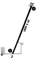
| Runways: | 03/21 |
| Longest Runway: | 03/21 is 2899 ft (884 m) long |
| Runways with an Instrument Approach: |
C66 Airport Runway Details
| Runway 03/21 | 2899 ft x 60 ft (884 m x 18 m) | |
| Surface: | Asphalt - Good condition - No special surface treatment | |
| Runway Edge Lights: | Medium Intensity | |
Runway Weight Bearing Capacity (in thousands of pounds) |
||
| Single Wheel Landing Gear: | 10.0 | |
Runway 03 |
Runway 21 |
|
Elevation: |
753.0 | 748.0 |
Latitude: |
40-55-33.8350N | 40-56-00.1240N |
Longitude: |
090-37-59.4910W | 090-37-44.4950W |
|
Runway True Alignment: |
023 | 203 |
Glide Path Angle: |
3.5 degrees | 3.0 degrees |
Traffic Pattern: |
Left | Left |
Runway Markings Type: |
Basic | Basic |
Runway Markings Condition: |
Good | Good |
Object at End: |
TREE | TREE |
Object Height: |
42 | 52 |
Distance from End: |
663 | 776 |
Object Centerline Offset: |
155 ft. right of centerline | 175 ft. right of centerline |
Visual Glide Slope Indicators: |
2-Light PAPI On Left Side Of Runway | 2-Light PAPI On Left Side Of Runway |
REIL: |
No | No |
Touchdown Lights: |
No | No |
Centerline Lights: |
No | No |
Threshold Crossing Height: |
29 | 21 |
Services
Airframe Repair: |
Major |
Powerplant Repair: |
Major |
Bottled Oxygen: |
None |
Bulk Oxygen: |
None |
Fuel Available: |
100LL, Jet A |
Landing Fees: |
No |
Parking: |
Hangars and tiedowns available |
Maps & Diagrams
C66 Sectional
Flight Planning
at skyvector.com
at skyvector.com