Location
Latitude: |
40-46-58.7000N (40.782972) |
Longitude: |
091-07-32.1000W (-91.125583) |
Elevation: |
698.7 feet MSL (213 m MSL) |
Magnetic Variation: |
1.4 W (as of April 2024 from WMM2020 model) |
Time Zone: |
UTC -6.0 (Standard Time) UTC -5.0 (Daylight Savings Time) |
From City: |
02 N.M. SW of Burlington, Iowa |
Found On: |
Chicago Chart |
FAA Region: |
ACE |
Contacts
Manager: |
Publicly owned: |
| SARA SANDBURG 2515 SUMMER ST BURLINGTON, IA 52601 319-754-1414 |
SE IOWA REG ARPT AUTHORITY 2515 SUMMER STREET BURLINGTON, IA 52601-3330 319-754-1414 |
Operations
Airport Status: |
Operational |
Facility Use: |
Public |
Type: |
Airport |
Activation Date: |
04/1940 |
Control tower: |
No |
Attendance (Months/Days/Hours): |
Months/Days/Hours ALL/ALL/0700-1900 |
Boundary ARTCC: |
ZAU (Chicago) |
Responsible ARTCC: |
ZAU (Chicago) |
Lighting Schedule: |
SEE RMK |
Segmented Circle Indicator: |
Yes |
Traffic Pattern Altitude (MSL): |
1699 feet (518 m) |
NOTAMs Facility: |
BRL |
NOTAM-D Service: |
Yes |
International Airport of Entry: |
No |
Customs Landing Rights: |
No |
Military Landing Rights: |
Yes |
Civil/Military Joint Use: |
No |
Based Aircraft
| Single Engine: | 27 |
| Multi Engine: | 2 |
| GA Helicopters: | 1 |
Annual Operations (as of 05/09/2022)
| Total Operations: | 17550 | |
| Commercial: | 1629 | 9.3% |
| Air Taxi: | 2784 | 15.9% |
| GA Local: | 5220 | 29.7% |
| GA Itinerant: | 7830 | 44.6% |
| Military Aircraft: | 87 | 0.5% |
Communications
| CTAF: | 123.000 |
| Unicom: | 123.000 |
| ASOS: | 118.025 (319-752-6246) |
- APCH/DEP SVC PRVDD BY CHICAGO ARTCC ON FREQS 135.6/370.95 (BURLINGTON RCAG).
Fixed Based Operators (FBOs) & Fuel
(Click on a business for detail)
Please help us keep this information up to date. This is a FREE SERVICE just like everything else on Airport Guide! If you see that a business needs to be added, modified, or deleted please fill out our Update Form.
To add, modify, or delete a business click here.
Please help us keep this information up to date. This is a FREE SERVICE just like everything else on Airport Guide! If you see that a business needs to be added, modified, or deleted please fill out our Update Form.
Area Code: 319 |
| Business Name | Frequency | Phone | Fuel Grade |
|---|---|---|---|
| Remmers Aviation, Inc.
Update FBO info |
Unicom 123.0 | 754-4601 | 100LL, Jet A |
Flight Service Stations
| Primary | Alternate | |
| FSS on Field: | N | |
| FSS Name (ID): | Fort Dodge(FOD) | |
| Frequency: | ||
| Toll Free Phone: | 1-800-WX-BRIEF |
Instrument Procedures / Charts
FAA Terminal Procedures valid from 0901Z 03/21/24 to 0901Z 04/18/24.
There are various types of charts available for an airport. They are listed in the Page Type column. Here is a legend for those types:
APD - Airport Diagram
DP - Departure Procedure Charts
HOT - Hot Spots
IAP - Instrument Approach Procedure Charts
MIN - Minimums
STAR - Standard Terminal Arrival Charts
| Page Type | Page Name | Volume | Action Since Last Cycle |
|---|---|---|---|
| APD | AIRPORT DIAGRAM | NC-3 | |
| IAP | ILS OR LOC RWY 36 | NC-3 | |
| IAP | RNAV (GPS) RWY 12 | NC-3 | |
| IAP | RNAV (GPS) RWY 30 | NC-3 | |
| IAP | RNAV (GPS) RWY 36 | NC-3 | |
| IAP | VOR RWY 12 | NC-3 | |
| IAP | VOR RWY 30 | NC-3 | |
| MIN | ALTERNATE MINIMUMS | NC-3 | |
| MIN | TAKEOFF MINIMUMS | NC-3 |
Terminal Procedures are only available for airports in several countries with more being added all the time. If you are looking for a specific country's charts, please send an email to support(at)airportguide.com stating the country name. This will be used to prioritize the implementation.
Navigation Aids (Navaids) near BRL
| Dist (NM) | ID | Morse Code | Name | Type | Freq | True Hdg | Mag Hdg |
|---|---|---|---|---|---|---|---|
| 7.7 | BR | _ . . . . _ . | Burns | NDB | 390 | 179 | 180 |
| 9.8 | BRL | _ . . . . _ . . _ . . | Burlington | VOR-DME | 111.40 | 111 | 113 |
| 20.3 | MPZ | _ _ . _ _ . _ _ . . | Mount Pleasant | NDB | 212 | 299 | 300 |
| 23.7 | EOK | . _ _ _ _ . _ | Keokuk | NDB | 366 | 216 | 217 |
| 30.2 | JZY | . _ _ _ _ _ . . _ . _ _ | Macomb | NDB | 251 | 121 | 123 |
| 32.7 | GBG | _ _ . _ . . . _ _ . | Galesburg | DME | 109.8 | 73 | 75 |
| 35.0 | DDD | _ . . _ . . _ . . | Port City | DME | 116.5 | 358 | 359 |
| 38.8 | AWG | . _ . _ _ _ _ . | Washington | NDB | 219 | 320 | 321 |
| 39.1 | MZV | _ _ _ _ . . . . . _ | Moline | VOR-DME | 114.40 | 34 | 36 |
| 41.4 | FFL | . . _ . . . _ . . _ . . | Fairfield | NDB | 332 | 289 | 290 |
| 49.4 | IOW | . . _ _ _ . _ _ | Iowa City | VOR-DME | 116.20 | 333 | 334 |
| 49.5 | CTK | _ . _ . _ _ . _ | Canton | NDB | 236 | 104 | 106 |
| 54.1 | UI | . . _ . . | Quincy | NDB | 293 | 186 | 187 |
| 55.4 | DVN | _ . . . . . _ _ . | Davenport Municipal | VOT | 111.80 | 25 | 27 |
| 56.4 | OTM | _ _ _ _ _ _ | Ottumwa | VOR-DME | 111.60 | 285 | 286 |
| 56.5 | UIN | . . _ . . _ . | Quincy | TACAN | 113.60 | 187 | 188 |
| 59.3 | BEX | _ . . . . _ . . _ | Bloomfield | NDB | 269 | 268 | 269 |
| 60.9 | PIA | . _ _ . . . . _ | Peoria | VORTAC | 115.20 | 95 | 97 |
| 62.6 | CVA | _ . _ . . . . _ . _ | Davenport | VORTAC | 113.80 | 27 | 29 |
| 66.9 | FN | . . _ . _ . | Hillz | NDB | 517 | 29 | 31 |
Nearby Airports with Fuel
Notices to Airmen (NOTAMS)
Remarks
| A110-1 | LINE OF SIGHT VISION BLOCKED BETWEEN RYS 36 & 12. |
| A110-2 | RY 36 IS CALM WIND RY. |
| A110-3 | SELF SERVICE FUEL STATION AVAILABLE ON NORTH END OF APRON. |
| A110-4 | SFC CONDITIONS UNMNT BTN 1900-0600 DLY. |
| A110-7 | FOR CD IF UNA TO CTC ON FSS FREQ, CTC CHICAGO ARTCC AT 630-906-8921. |
| A13 | FAX 319-754-1424. |
| A57-18 | RWY 18 APCH RATIO 25:1 |
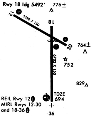
| A81-APT | ACTVT MALSR RWY 36; REIL RWYS 12, 18 & 30; VASI RWY 12; PAPI RWY 18 & 30; MIRL RWY 12/30; HIRL RWY 18/36 - CTAF. |
Runways
Runway Summary
| Runways: | 12/30 18/36 |
| Longest Runway: | 18/36 is 6102 ft (1860 m) long |
| Runways with an Instrument Approach: | 36 |
BRL Airport Runway Details
| Runway 12/30 | 5351 ft x 100 ft (1631 m x 30 m) | |
| Runway Length Source: | 3RD PARTY SURVEY as of 08/13/2021 | |
| Surface: | Concrete - Fair condition - Saw-cut or plastic grooved | |
| Runway Pavement Class: | 24 /R/C/X/T | |
| Runway Edge Lights: | Medium Intensity | |
Runway Weight Bearing Capacity (in thousands of pounds) |
||
| Single Wheel Landing Gear: | 37.0 | |
| Dual Wheel Landing Gear: | 58.0 | |
Runway 12 |
Runway 30 |
|
Elevation: |
692.7 | 698.1 |
Latitude: |
40-47-29.0642N | 40-47-02.9927N |
Longitude: |
091-08-09.5515W | 091-07-09.0372W |
|
Runway True Alignment: |
120 | 300 |
Glide Path Angle: |
3.0 degrees | 3.0 degrees |
Traffic Pattern: |
Right | Left |
Runway Markings Type: |
Nonprecision Instrument | Nonprecision Instrument |
Runway Markings Condition: |
Good | Good |
Object at End: |
ROAD | |
Object Height: |
16 | |
Distance from End: |
600 | |
Object Centerline Offset: |
300 ft. right of centerline | |
Visual Glide Slope Indicators: |
4-Box VASI On Left Side Of Runway | 4-Light PAPI On Left Side Of Runway |
REIL: |
Yes | Yes |
Threshold Crossing Height: |
39 | 30 |
Threshold Elevation: |
697.1 | |
Displaced Threshold: |
500 | |
Threshold Latitude: |
40-47-05.4306N | |
Threshold Longitude: |
091-07-14.6929W | |
Declared Distances |
||
Take Off Run Avbl. (TORA): |
4850 | 5350 |
Take Off Distance Avbl. (TODA): |
5350 | 5350 |
Actual Stop Dist. Avbl. (ASDA): |
4850 | 5350 |
Landing Dist. Avbl. (LDA): |
5350 | 4850 |
| Runway 18/36 | 6102 ft x 100 ft (1860 m x 30 m) | |
| Runway Length Source: | 3RD PARTY SURVEY as of 08/13/2021 | |
| Surface: | Concrete - Fair condition - Saw-cut or plastic grooved | |
| Runway Pavement Class: | 30 /R/C/X/T | |
| Runway Edge Lights: | High Intensity | |
Runway Weight Bearing Capacity (in thousands of pounds) |
||
| Single Wheel Landing Gear: | 65.0 | |
| Dual Wheel Landing Gear: | 90.0 | |
Runway 18 |
Runway 36 |
|
Elevation: |
695.4 | 677.4 |
Latitude: |
40-47-13.6791N | 40-46-13.3913N |
Longitude: |
091-07-26.1287W | 091-07-25.4998W |
|
Runway True Alignment: |
180 | 360 |
ILS Type: |
ILS | |
Glide Path Angle: |
3.0 degrees | 0.0 degrees |
Traffic Pattern: |
Right | Left |
Runway Markings Type: |
Nonprecision Instrument | Precision Instrument |
Runway Markings Condition: |
Good | Good |
Object at End: |
TREES | TREE |
Object Height: |
104 | 40 |
Distance from End: |
2588 | 2000 |
Object Centerline Offset: |
300 ft. right of centerline | |
Visual Glide Slope Indicators: |
4-Light PAPI On Left Side Of Runway | |
Approach Light System: |
1,400 Foot Medium Intensity Approach Lighting System With Runway Alignment Indicator Lights | |
REIL: |
Yes | |
Threshold Crossing Height: |
40 | |
Declared Distances |
||
Take Off Run Avbl. (TORA): |
6102 | 6102 |
Take Off Distance Avbl. (TODA): |
6102 | 6102 |
Actual Stop Dist. Avbl. (ASDA): |
6102 | 6102 |
Landing Dist. Avbl. (LDA): |
6102 | 6102 |
Services
Airframe Repair: |
Major |
Powerplant Repair: |
Major |
Bottled Oxygen: |
None |
Bulk Oxygen: |
None |
Fuel Available: |
100LL |
Landing Fees: |
No |
Parking: |
Hangars and tiedowns available |
Maps & Diagrams
BRL Sectional
Flight Planning
at skyvector.com
at skyvector.com