Location
Latitude: |
41-55-14.7000N (41.92075) |
Longitude: |
071-29-29.1000W (-71.491417) |
Elevation: |
440.5 feet MSL (134 m MSL) |
Magnetic Variation: |
13.9 W (as of April 2024 from WMM2020 model) |
Time Zone: |
UTC -5.0 (Standard Time) UTC -4.0 (Daylight Savings Time) |
From City: |
03 N.M. E of Pawtucket, Rhode Island |
Found On: |
New York Chart |
FAA Region: |
ANE |
Contacts
Manager: |
Publicly owned: |
| IFTIKHAR AHMAD RHODE ISLAND AIRPORT CORP, 2000 POST RD WARWICK, RI 02886 401-691-2000 |
STATE OF RHODE ISLAND RHODE ISLAND AIRPORT CORP, 2000 POST RD WARWICK, RI 02886 401-691-2000 |
Operations
Airport Status: |
Operational |
Facility Use: |
Public |
Type: |
Airport |
Activation Date: |
12/1951 |
Control tower: |
No |
Attendance (Months/Days/Hours): |
Months/Days/Hours ALL/SUN-SAT/0700-1700 |
Boundary ARTCC: |
ZBW (Boston) |
Responsible ARTCC: |
ZBW (Boston) |
Lighting Schedule: |
SEE RMK |
Segmented Circle Indicator: |
Yes |
Traffic Pattern Altitude (MSL): |
1440 feet (439 m) |
NOTAMs Facility: |
SFZ |
NOTAM-D Service: |
Yes |
International Airport of Entry: |
No |
Customs Landing Rights: |
Yes |
Military Landing Rights: |
Yes |
Civil/Military Joint Use: |
No |
Based Aircraft
| Single Engine: | 32 |
| Multi Engine: | 1 |
| GA Helicopters: | 1 |
Annual Operations (as of 07/31/2023)
| Total Operations: | 12042 | |
| Air Taxi: | 471 | 3.9% |
| GA Local: | 7339 | 60.9% |
| GA Itinerant: | 4141 | 34.4% |
| Military Aircraft: | 91 | 0.8% |
Communications
| CTAF: | 123.075 |
| Unicom: | 123.075 |
| Approach: | PROVIDENCE 123.675 123.675 123.675 123.675 123.675 BOSTON ARTCC |
| Departure: | PROVIDENCE 123.675 123.675 123.675 123.675 123.675 BOSTON ARTCC |
| AWOS-3PT: | 120.775 (401-334-0324) |
- APCH/DEP SVC PRVDD BY BOSTON ARTCC ON FREQS 124.85/307.9 (WOODSTOCK RCAG) WHEN PROVIDENCE APCH CTL CLSD.
Fixed Based Operators (FBOs) & Fuel
(Click on a business for detail)
Please help us keep this information up to date. This is a FREE SERVICE just like everything else on Airport Guide! If you see that a business needs to be added, modified, or deleted please fill out our Update Form.
To add, modify, or delete a business click here.
Please help us keep this information up to date. This is a FREE SERVICE just like everything else on Airport Guide! If you see that a business needs to be added, modified, or deleted please fill out our Update Form.
Area Code: 401 |
| Business Name | Frequency | Phone | Fuel Grade |
|---|---|---|---|
| New England Aviation, Inc.
Update FBO info |
334-3838 | 100LL | |
| Skylanes, Inc.
Update FBO info |
333-1440 | 100LL |
Flight Service Stations
| Primary | Alternate | |
| FSS on Field: | N | |
| FSS Name (ID): | Bridgeport(BDR) | |
| Frequency: | ||
| Toll Free Phone: | 1-800-WX-BRIEF |
Instrument Procedures / Charts
FAA Terminal Procedures valid from 0901Z 03/21/24 to 0901Z 04/18/24.
There are various types of charts available for an airport. They are listed in the Page Type column. Here is a legend for those types:
APD - Airport Diagram
DP - Departure Procedure Charts
HOT - Hot Spots
IAP - Instrument Approach Procedure Charts
MIN - Minimums
STAR - Standard Terminal Arrival Charts
| Page Type | Page Name | Volume | Action Since Last Cycle |
|---|---|---|---|
| IAP | LOC RWY 05 | NE-1 | |
| IAP | RNAV (GPS) RWY 05 | NE-1 | |
| IAP | RNAV (GPS) RWY 23 | NE-1 | |
| IAP | VOR-A | NE-1 | |
| IAP | VOR-B | NE-1 | |
| MIN | ALTERNATE MINIMUMS | NE-1 | |
| MIN | TAKEOFF MINIMUMS | NE-1 | |
| STAR | WIPOR THREE (RNAV) | NE-1 |
Terminal Procedures are only available for airports in several countries with more being added all the time. If you are looking for a specific country's charts, please send an email to support(at)airportguide.com stating the country name. This will be used to prioritize the implementation.
Navigation Aids (Navaids) near SFZ
| Dist (NM) | ID | Morse Code | Name | Type | Freq | True Hdg | Mag Hdg |
|---|---|---|---|---|---|---|---|
| 9.1 | AR | . _ . _ . | Armin | NDB | 356 | 136 | 150 |
| 12.1 | PVD | . _ _ . . . . _ _ . . | Providence | VOR-DME | 115.60 | 166 | 180 |
| 12.2 | PVD | . _ _ . . . . _ _ . . | Providence | VOT | 108.20 | 166 | 180 |
| 14.0 | IHM | . . . . . . _ _ | Mansfield | NDB | 220 | 69 | 83 |
| 15.9 | PUT | . _ _ . . . _ _ | Putnam | VOR-DME | 117.40 | 277 | 291 |
| 20.1 | OW | _ _ _ . _ _ | Stoge | NDB | 397 | 53 | 67 |
| 21.4 | TAN | _ . _ _ . | Taunton | NDB | 227 | 97 | 111 |
| 26.7 | ORH | _ _ _ . _ . . . . . | Worcester | VOT | 108.20 | 321 | 335 |
| 31.5 | ORW | _ _ _ . _ . . _ _ | Norwich | VOR-DME | 110.00 | 226 | 240 |
| 33.8 | BE | _ . . . . | Bedds | NDB | 332 | 7 | 21 |
| 33.9 | BED | _ . . . . _ . . | Bedford | VOT | 110.00 | 15 | 29 |
| 34.4 | BOS | _ . . . _ _ _ . . . | Boston | VOT | 111.00 | 40 | 54 |
| 34.4 | BOS | _ . . . _ _ _ . . . | Boston | VOR-DME | 112.70 | 40 | 54 |
| 35.0 | SKR | . . . _ . _ . _ . | Shaker Hill | NDB | 251 | 23 | 37 |
| 37.9 | IMR | . . _ _ . _ . | Marshfield | NDB | 368 | 73 | 87 |
| 39.6 | LQ | . _ . . _ _ . _ | Lyndy | NDB | 382 | 36 | 50 |
| 39.6 | FIT | . . _ . . . _ | Fitchburg | NDB | 365 | 342 | 356 |
| 43.4 | GON | _ _ . _ _ _ _ . | Groton | VOR-DME | 110.85 | 215 | 229 |
| 43.7 | GON | _ _ . _ _ _ _ . | Groton | VOT | 110.25 | 215 | 229 |
| 45.2 | GDM | _ _ . _ . . _ _ | Gardner | VOR-DME | 110.60 | 326 | 340 |
Nearby Airports with Fuel
Notices to Airmen (NOTAMS)
Remarks
| A110-10 | SEASONAL GLDR OPS INVOF ARPT SR-SS. |
| A110-11 | RWY CONDS MAY NOT BE MNT OR RPRTD WHEN AP IS UNATNDD. CTC RI AP CORPORATION OPS AT 401-691-2265. |
| A110-12 | FOR CD WHEN APCH CLSD CTC BOSTON ARTCC AT 603-879-6859. |
| A110-13 | AP WILDLIFE HAZ DEER ACT INCREASED HN. |
| A110-14 | NMRS UNLGTD OBSTNS UP TO 150 FT AGL SRNDG AIRFIELD. |
| A110-15 | BIRDS & WILDLIFE ON & INVOF ARPT. |
| A110-2 | LGTD 250 FT MSL TWR 3-2/5 MI SE. |
| A110-6 | OVNGT PRKG FEE. |
| A110-7 | +50 FT DROPOFF 250 FT FM RWY 05 END, +40 FT DROPOFF 250 FT FM RWY 23 END. |
| A110-8 | SEASONAL SKYDIVING NE SIDE OF AIRFIELD. |
| A110-9 | NOISE ABATEMENT PROCS IN EFCT, CTC AMGR. |
| A24 | LDG FEE FOR COML ACFT & NON-RHODE ISLAND REGISTERED ACFT. |
| A58-05 | +10 FT TREES 150 FT FM THR, 180 FT L; +10 FT TREES 120 FT FM THR, 180 FT R. |
| A58-23 | +15 FT TREES 170 FT FM THR, 90 FT R; +10 FT TREES 120 FT FM THR, 150 FT L. |
| A81-APT | ACTVT MALS RWY 05; REIL RWY 23, 15 & 33; PAPI RWY 05, 15 & 23; HIRL RWY 05/23; MIRL RWY 15/33; TWY LGTS - CTAF. |
| E111 | EXISTED PRIOR TO 1959. |
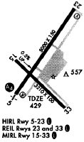
Runways
Runway Summary
| Runways: | 05/23 15/33 |
| Longest Runway: | 05/23 is 5000 ft (1524 m) long |
| Runways with an Instrument Approach: | 05 |
SFZ Airport Runway Details
| Runway 05/23 | 5000 ft x 100 ft (1524 m x 30 m) | |
| Runway Length Source: | 3RD PARTY SURVEY as of 04/22/2010 | |
| Surface: | Asphalt - Good condition - No special surface treatment | |
| Runway Edge Lights: | High Intensity | |
Runway Weight Bearing Capacity (in thousands of pounds) |
||
| Single Wheel Landing Gear: | 30.0 | |
| Dual Wheel Landing Gear: | 60.0 | |
Runway 05 |
Runway 23 |
|
Elevation: |
418.7 | 419.0 |
Latitude: |
41-54-59.8847N | 41-55-41.7462N |
Longitude: |
071-29-44.9665W | 071-29-09.8510W |
|
Runway True Alignment: |
032 | 212 |
ILS Type: |
LOC/DME | |
Glide Path Angle: |
3.0 degrees | 3.0 degrees |
Traffic Pattern: |
Left | Left |
Runway Markings Type: |
Nonprecision Instrument | Nonprecision Instrument |
Runway Markings Condition: |
Fair | Fair |
Object at End: |
TREES | TREES |
Object Height: |
53 | 20 |
Distance from End: |
2200 | 900 |
Object Centerline Offset: |
700 ft. right of centerline | 150 ft. right of centerline |
Visual Glide Slope Indicators: |
4-Light PAPI On Right Side Of Runway | 4-Light PAPI On Left Side Of Runway |
Approach Light System: |
1,400 Foot Medium Intensity Approach Lighting System | |
REIL: |
Yes | |
Threshold Crossing Height: |
52 | 35 |
| Runway 15/33 | 3211 ft x 75 ft (979 m x 23 m) | |
| Runway Length Source: | 3RD PARTY SURVEY as of 04/22/2010 | |
| Surface: | Asphalt - Good condition - No special surface treatment | |
| Runway Edge Lights: | Medium Intensity | |
Runway Weight Bearing Capacity (in thousands of pounds) |
||
| Single Wheel Landing Gear: | 12.5 | |
Runway 15 |
Runway 33 |
|
Elevation: |
425.5 | 440.2 |
Latitude: |
41-55-17.2020N | 41-54-53.0785N |
Longitude: |
071-29-45.4356W | 071-29-17.8568W |
|
Runway True Alignment: |
140 | 320 |
Glide Path Angle: |
3.5 degrees | 0.0 degrees |
Traffic Pattern: |
Left | Left |
Runway Markings Type: |
Basic | Basic |
Runway Markings Condition: |
Good | Good |
Object at End: |
TREES | TREES |
Object Height: |
39 | 24 |
Distance from End: |
850 | 535 |
Object Centerline Offset: |
700 ft. right of centerline | 150 ft. right of centerline |
Visual Glide Slope Indicators: |
4-Light PAPI On Left Side Of Runway | |
REIL: |
Yes | Yes |
Threshold Crossing Height: |
35 |
Services
Airframe Repair: |
Minor |
Powerplant Repair: |
Minor |
Bottled Oxygen: |
None |
Bulk Oxygen: |
None |
Fuel Available: |
100LL, Mogas |
Landing Fees: |
No |
Parking: |
Hangars and tiedowns available |
Maps & Diagrams
SFZ Sectional
Flight Planning
at skyvector.com
at skyvector.com