Location
Latitude: |
40-51-00.0000N (40.85) |
Longitude: |
077-50-51.3000W (-77.847583) |
Elevation: |
1231.3 feet MSL (375 m MSL) |
Magnetic Variation: |
10.6 W (as of May 2024 from WMM2020 model) |
Time Zone: |
UTC -5.0 (Standard Time) UTC -4.0 (Daylight Savings Time) |
From City: |
03 N.M. N of State College, Pennsylvania |
Found On: |
Detroit Chart |
FAA Region: |
AEA |
Contacts
Manager: |
Publicly owned: |
| BRYAN RODGERS 2535 FOX HILL RD STATE COLLEGE, PA 16803 814-865-4042 |
PENN STATE UNIVERSITY 2535 FOX HILL RD STATE COLLEGE, PA 16803 814-865-4042 |
Operations
Airport Status: |
Operational |
Facility Use: |
Public |
Type: |
Airport |
Activation Date: |
03/1959 |
Control tower: |
Yes |
Attendance (Months/Days/Hours): |
Months/Days/Hours ALL/ALL/ALL |
Boundary ARTCC: |
ZNY (New York) |
Responsible ARTCC: |
ZNY (New York) |
Lighting Schedule: |
SEE RMK |
Segmented Circle Indicator: |
Yes |
Traffic Pattern Altitude (MSL): |
2231 feet (680 m) |
NOTAMs Facility: |
UNV |
NOTAM-D Service: |
Yes |
International Airport of Entry: |
No |
Customs Landing Rights: |
No |
Military Landing Rights: |
Yes |
Civil/Military Joint Use: |
No |
Aircraft Rescue and Firefighting: |
Class I ARFF Index: B Air Carrier Service: Scheduled Certification Date: 05/1985 |
Based Aircraft
| Single Engine: | 42 |
| Multi Engine: | 5 |
| Jet Engine: | 4 |
| GA Helicopters: | 1 |
| Gliders: | 1 |
Annual Operations (as of 12/31/2022)
| Total Operations: | 41759 | |
| Commercial: | 1376 | 3.3% |
| Air Taxi: | 7932 | 19.0% |
| GA Local: | 16924 | 40.5% |
| GA Itinerant: | 14806 | 35.5% |
| Military Aircraft: | 721 | 1.7% |
Communications
| CTAF: | 128.475 |
| Unicom: | 122.950 |
| Tower: | UNIVERSITY PARK 128.475 Hrs: 0600-2200 |
| Clearance Del.: | 125.725 |
| Ground: | 125.725 |
| Approach: | NEW YORK ARTCC |
| Departure: | NEW YORK ARTCC |
| ATIS: | 127.65 Hrs: 24 |
| AWOS-3: | 127.65 (814-865-8799) |
- APCH/DEP SVC PRVDD BY NEW YORK ARTCC ON FREQS 134.8/338.3 (PHILIPSBURG RCAG) WHEN TWR CLSD.
- CLEARANCE DELIVERY PVDD BY NEW YORK ARTCC ON FREQ 118.55 WHEN TWR CLSD.
Fixed Based Operators (FBOs) & Fuel
(Click on a business for detail)
Please help us keep this information up to date. This is a FREE SERVICE just like everything else on Airport Guide! If you see that a business needs to be added, modified, or deleted please fill out our Update Form.
To add, modify, or delete a business click here.
Please help us keep this information up to date. This is a FREE SERVICE just like everything else on Airport Guide! If you see that a business needs to be added, modified, or deleted please fill out our Update Form.
Area Code: 814 |
| Business Name | Frequency | Phone | Fuel Grade |
|---|---|---|---|
| Thoroughbred Aviation
Update FBO info |
238-1693 | ||
| University Park Airport
Update FBO info |
Unicom 122.8 | 865-5511 | 100LL, Jet A |
Flight Service Stations
| Primary | Alternate | |
| FSS on Field: | N | |
| FSS Name (ID): | Altoona(AOO) | |
| Frequency: | ||
| Toll Free Phone: | 1-800-WX-BRIEF |
Instrument Procedures / Charts
FAA Terminal Procedures valid from 0901Z 03/21/24 to 0901Z 04/18/24.
There are various types of charts available for an airport. They are listed in the Page Type column. Here is a legend for those types:
APD - Airport Diagram
DP - Departure Procedure Charts
HOT - Hot Spots
IAP - Instrument Approach Procedure Charts
MIN - Minimums
STAR - Standard Terminal Arrival Charts
| Page Type | Page Name | Volume | Action Since Last Cycle |
|---|---|---|---|
| APD | AIRPORT DIAGRAM | NE-4 | |
| IAP | ILS OR LOC RWY 24 | NE-4 | |
| IAP | RNAV (GPS) RWY 06 | NE-4 | |
| IAP | RNAV (GPS) RWY 24 | NE-4 | |
| MIN | ALTERNATE MINIMUMS | NE-4 | |
| MIN | TAKEOFF MINIMUMS | NE-4 |
Terminal Procedures are only available for airports in several countries with more being added all the time. If you are looking for a specific country's charts, please send an email to support(at)airportguide.com stating the country name. This will be used to prioritize the implementation.
Navigation Aids (Navaids) near SCE
| Dist (NM) | ID | Morse Code | Name | Type | Freq | True Hdg | Mag Hdg |
|---|---|---|---|---|---|---|---|
| 6.0 | UN | . . _ _ . | Penue | NDB | 388 | 53 | 64 |
| 7.7 | PSB | . _ _ . . . . _ . . . | Philipsburg | VORTAC | 115.50 | 301 | 312 |
| 23.0 | TON | _ _ _ _ _ . | Tyrone | VORTAC | 114.90 | 252 | 262 |
| 25.6 | ETG | . _ _ _ . | Keating | VORTAC | 116.00 | 328 | 339 |
| 37.7 | AOO | . _ _ _ _ _ _ _ | Altoona | VOR | 108.80 | 213 | 223 |
| 40.2 | SLT | . . . . _ . . _ | Slate Run | VORTAC | 113.90 | 352 | 363 |
| 43.9 | SEG | . . . . _ _ . | Selinsgrove | VOR-DME | 110.40 | 94 | 105 |
| 44.8 | REC | . _ . . _ . _ . | Revloc | VOR-DME | 110.60 | 246 | 256 |
| 48.3 | HAR | . . . . . _ . _ . | Harrisburg | VORTAC | 112.50 | 132 | 143 |
| 54.3 | SFK | . . . . . _ . _ . _ | Stonyfork | VOR-DME | 108.60 | 20 | 31 |
| 54.6 | MIP | _ _ . . . _ _ . | Milton | VORTAC | 109.20 | 78 | 89 |
| 55.2 | JST | . _ _ _ . . . _ | Johnstown | VOR-DME | 113.00 | 234 | 244 |
| 55.2 | THS | _ . . . . . . . | St Thomas | VORTAC | 115.00 | 184 | 195 |
| 55.7 | CX | _ . _ . _ . . _ | Latle | NDB | 219 | 136 | 147 |
| 56.3 | MD | _ _ _ . . | Enola | NDB | 204 | 129 | 140 |
| 56.7 | FQM | . . _ . _ _ . _ _ _ | Williamsport | VOR-DME | 114.40 | 58 | 69 |
| 56.9 | INP | . . _ . . _ _ . | Indiana | NDB | 242 | 257 | 267 |
| 57.5 | PIX | . _ _ . . . _ . . _ | Picture Rocks | NDB | 344 | 63 | 74 |
| 59.5 | RAV | . _ . . _ . . . _ | Ravine | VORTAC | 114.60 | 106 | 117 |
| 63.1 | MDT | _ _ _ . . _ | Harrisburg | VOT | 110.00 | 128 | 139 |
Nearby Airports with Fuel
Notices to Airmen (NOTAMS)
Remarks
| A110-10 | 35 FT AGL LGT POLES ON THE N EDGE OF DEICE APN. |
| A110-11 | AIR CGO APRN RSTD TO ACFT LESS THAN 12500 LBS. |
| A110-3 | ACFT ON EITHER END RWY 06/24 CANNOT BE SEEN ON OTHER END DUE TO RWY GRADE. |
| A110-4 | STUDENT TRAINING 2.5 NM NE AT BELLEFONTE ARPT. |
| A110-5 | DEICING EQUIP AVBL ON APN ADJ TO TWY B BTN TWYS D & B3. |
| A110-7 | (A76) SAWRS. |
| A24 | LNDG FEE FOR SNGL ENG, MULTI ENG ACFT & HELICOPTERS. SPL EVENT FEE FOR SNGL ENG, MULTI ENG ACFT & HELICOPTERS ON UNIVERSITY HOME FOOTBALL GAME WKENDS. |
| A26 | PPR 24 HRS FOR UNSKED ACR OPS WITH MORE THAN 9 PAX SEATS BTN 0400-0900Z CALL AMGR. |
| A34-06/24 | GRVD PORTION OF RY CTR 80 FT. |
| A81-APT | WHEN ATCT CLSD ACTVT MALSR RWY 24; REIL RWY 06; HIRL RWY 06/24 & TWY LGTS - CTAF. |
| E147 | TRAFFIC PATTERN ALTITUDE FOR SINGLE ENGINE ACRFT 961 FT; MULTI ENGINE ACRFT 1461 FT. |
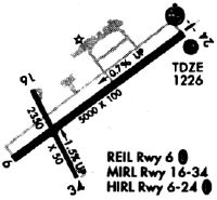
Runways
Runway Summary
| Runways: | 06/24 |
| Longest Runway: | 06/24 is 6701 ft (2042 m) long |
| Runways with an Instrument Approach: | 24 |
SCE Airport Runway Details
| Runway 06/24 | 6701 ft x 150 ft (2042 m x 46 m) | |
| Runway Length Source: | 3RD PARTY SURVEY as of 10/31/2013 | |
| Surface: | Asphalt - Good condition - Saw-cut or plastic grooved | |
| Runway Pavement Class: | 44 /F/B/X/U | |
| Runway Edge Lights: | High Intensity | |
Runway Weight Bearing Capacity (in thousands of pounds) |
||
| Single Wheel Landing Gear: | 50.0 | |
| Dual Wheel Landing Gear: | 110.0 | |
Runway 06 |
Runway 24 |
|
Elevation: |
1231.2 | 1191.8 |
Latitude: |
40-50-40.0048N | 40-51-20.0795N |
Longitude: |
077-51-26.0095W | 077-50-16.6085W |
|
Runway True Alignment: |
053 | 233 |
ILS Type: |
ILS/DME | |
Glide Path Angle: |
3.0 degrees | 3.0 degrees |
Traffic Pattern: |
Right | Left |
Runway Markings Type: |
Precision Instrument | Precision Instrument |
Runway Markings Condition: |
Good | Good |
Object at End: |
TREES | |
Object Height: |
87 | |
Distance from End: |
2754 | |
Object Centerline Offset: |
107 ft. left of centerline | |
Visual Glide Slope Indicators: |
4-Light PAPI On Left Side Of Runway | 4-Light PAPI On Right Side Of Runway |
Runway Visual Range (RVR): |
Rollout | Touchdown |
Approach Light System: |
1,400 Foot Medium Intensity Approach Lighting System With Runway Alignment Indicator Lights | |
REIL: |
Yes | |
Threshold Crossing Height: |
45 | 55 |
Declared Distances |
||
Take Off Run Avbl. (TORA): |
6701 | 6701 |
Take Off Distance Avbl. (TODA): |
6701 | 6701 |
Actual Stop Dist. Avbl. (ASDA): |
6701 | 6701 |
Landing Dist. Avbl. (LDA): |
6701 | 6701 |
Services
Airframe Repair: |
Major |
Powerplant Repair: |
Minor |
Bottled Oxygen: |
None |
Bulk Oxygen: |
None |
Fuel Available: |
100LL |
Landing Fees: |
No |
Parking: |
Tiedowns available |
Maps & Diagrams
SCE Sectional
Flight Planning
at skyvector.com
at skyvector.com