Location
Latitude: |
40-17-12.3600N (40.286767) |
Longitude: |
076-34-37.1550W (-76.576988) |
Elevation: |
489.0 feet MSL (149 m MSL) |
Magnetic Variation: |
11.2 W (as of May 2024 from WMM2020 model) |
Time Zone: |
UTC -5.0 (Standard Time) UTC -4.0 (Daylight Savings Time) |
From City: |
02 N.M. S of Palmyra, Pennsylvania |
Found On: |
New York Chart |
FAA Region: |
AEA |
Contacts
Manager: |
Privately owned: |
| MICHELLE WOLF 1805 S FORGE RD PALMYRA, PA 17078 717-838-5519 |
DUANE REIGLE/MICHELLE WOLF 1805 S FORGE RD PALMYRA, PA 17078 717-838-5519 |
Operations
Airport Status: |
Operational |
Facility Use: |
Public |
Type: |
Airport |
Activation Date: |
10/1945 |
Control tower: |
No |
Attendance (Months/Days/Hours): |
Months/Days/Hours ALL/ALL/0900-1700 |
Boundary ARTCC: |
ZNY (New York) |
Responsible ARTCC: |
ZNY (New York) |
Lighting Schedule: |
SEE RMK |
Segmented Circle Indicator: |
No |
Traffic Pattern Altitude (MSL): |
1489 feet (454 m) |
NOTAMs Facility: |
IPT |
NOTAM-D Service: |
Yes |
International Airport of Entry: |
No |
Customs Landing Rights: |
No |
Military Landing Rights: |
No |
Civil/Military Joint Use: |
No |
Based Aircraft
| Single Engine: | 65 |
Annual Operations (as of 07/12/2023)
| Total Operations: | 30000 | |
| GA Local: | 24000 | 80.0% |
| GA Itinerant: | 6000 | 20.0% |
Communications
| CTAF: | 122.800 |
| Unicom: | 122.800 |
| Approach: | HARRISBURG 118.25 ;001-079 118.25 ;001-079 118.25 ;001-079 118.25 ;001-079 118.25 ;001-079 118.25 ;001-079 |
| Departure: | HARRISBURG 118.25 ;001-079 118.25 ;001-079 118.25 ;001-079 118.25 ;001-079 118.25 ;001-079 118.25 ;001-079 |
Fixed Based Operators (FBOs) & Fuel
(Click on a business for detail)
Please help us keep this information up to date. This is a FREE SERVICE just like everything else on Airport Guide! If you see that a business needs to be added, modified, or deleted please fill out our Update Form.
To add, modify, or delete a business click here.
Please help us keep this information up to date. This is a FREE SERVICE just like everything else on Airport Guide! If you see that a business needs to be added, modified, or deleted please fill out our Update Form.
Area Code: 717 |
| Business Name | Frequency | Phone | Fuel Grade |
|---|---|---|---|
| Reigle Aviation
Update FBO info |
838-5319 | 80, 100LL, Mogas | |
| Wachas Flying Service, Inc.
Update FBO info |
Unicom 122.8 | 838-5519 | 80, 100LL, Mogas |
Flight Service Stations
| Primary | Alternate | |
| FSS on Field: | N | |
| FSS Name (ID): | Williamsport(IPT) | |
| Frequency: | ||
| Toll Free Phone: | 1-800-WX-BRIEF |
Instrument Procedures / Charts
FAA Terminal Procedures valid from 0901Z 03/21/24 to 0901Z 04/18/24.
There are various types of charts available for an airport. They are listed in the Page Type column. Here is a legend for those types:
APD - Airport Diagram
DP - Departure Procedure Charts
HOT - Hot Spots
IAP - Instrument Approach Procedure Charts
MIN - Minimums
STAR - Standard Terminal Arrival Charts
| Page Type | Page Name | Volume | Action Since Last Cycle |
|---|---|---|---|
| IAP | RNAV (GPS)-A | NE-4 | |
| MIN | TAKEOFF MINIMUMS | NE-4 |
Terminal Procedures are only available for airports in several countries with more being added all the time. If you are looking for a specific country's charts, please send an email to support(at)airportguide.com stating the country name. This will be used to prioritize the implementation.
Navigation Aids (Navaids) near 58N
| Dist (NM) | ID | Morse Code | Name | Type | Freq | True Hdg | Mag Hdg |
|---|---|---|---|---|---|---|---|
| 9.0 | BZJ | _ . . . _ _ . . . _ _ _ | Bellgrove | NDB | 328 | 6 | 17 |
| 10.1 | MDT | _ _ _ . . _ | Harrisburg | VOT | 110.00 | 237 | 248 |
| 15.0 | MD | _ _ _ . . | Enola | NDB | 204 | 260 | 271 |
| 16.0 | RAV | . _ . . _ . . . _ | Ravine | VORTAC | 114.60 | 356 | 367 |
| 16.5 | LRP | . _ . . . _ . . _ _ . | Lancaster | VOR-DME | 117.30 | 127 | 138 |
| 20.7 | CX | _ . _ . _ . . _ | Latle | NDB | 219 | 251 | 262 |
| 22.6 | HAR | . . . . . _ . _ . | Harrisburg | VORTAC | 112.50 | 272 | 283 |
| 26.0 | EUD | . . . _ _ . . | York | NDB | 254 | 212 | 223 |
| 33.3 | SEG | . . . . _ _ . | Selinsgrove | VOR-DME | 110.40 | 335 | 346 |
| 44.4 | MIP | _ _ . . . _ _ . | Milton | VORTAC | 109.20 | 354 | 365 |
| 44.4 | ETX | . _ _ . . _ | East Texas | VOR-DME | 110.20 | 66 | 78 |
| 46.1 | HZL | . . . . _ _ . . . _ . . | Hazleton | VOR | 109.40 | 26 | 37 |
| 46.7 | PTW | . _ _ . _ . _ _ | Pottstown | VORTAC | 116.50 | 94 | 106 |
| 47.1 | MXE | _ _ _ . . _ . | Modena | VORTAC | 113.20 | 117 | 128 |
| 50.0 | APG | . _ . _ _ . _ _ . | Aberdeen | NDB | 349 | 154 | 165 |
| 51.0 | EMI | . _ _ . . | Westminster | VORTAC | 117.90 | 201 | 212 |
| 52.6 | PPM | . _ _ . . _ _ . _ _ | Phillips | VOR-DME | 108.40 | 159 | 170 |
| 57.6 | FJC | . . _ . . _ _ _ _ . _ . | Allentown | VORTAC | 117.50 | 62 | 74 |
| 57.6 | DQO | _ . . _ _ . _ _ _ _ | Dupont | VORTAC | 114.00 | 129 | 140 |
| 59.1 | UKT | . . _ _ . _ _ | Quakertown | NDB | 208 | 81 | 93 |
Nearby Airports with Fuel
Notices to Airmen (NOTAMS)
Remarks
| A110-2 | FOR CD CTC HARRISBURG APCH AT 800-932-0712. |
| A40-13/31 | NSTD LIRL; LGTS LCTD 125 FT L AND R OF CNTRLN. RWY 13; FIRST 110 FT UNLGTD. RWY 31; FIRST 60 FT UNLGTD. 1780 FT OF RWY LGTD. |
| A51-31 | DSPLCD THLD IDENTIFIED AT NIGHT BY ONE GREEN LGT EACH SIDE OF RWY. |
| A57-31 | CTLNG OBSTN GTR THAN 45 DEG SLP. |
| A58-13 | CROPS 132 FT FM RWY. |
| A58-31 | +15 FT ROAD 25-60 FT FROM RWY. |
| A81-APT | ACTVT LIRL RWY 13/31 - CTAF. |
| A81-BCN | ACTVT ROTG BCN - CTAF. |
Runways
Runway Summary
| Runways: | 13/31 |
| Longest Runway: | 13/31 is 1955 ft (596 m) long |
| Runways with an Instrument Approach: |
58N Airport Runway Details
| Runway 13/31 | 1955 ft x 40 ft (596 m x 12 m) | |
| Runway Length Source: | OWNER as of 07/05/2011 | |
| Surface: | Asphalt - Good condition - No special surface treatment | |
| Runway Edge Lights: | Non-standard lighting system Intensity | |
Runway Weight Bearing Capacity (in thousands of pounds) |
||
| Single Wheel Landing Gear: | 12.5 | |
Runway 13 |
Runway 31 |
|
Elevation: |
482.0 | 489.0 |
Latitude: |
40-17-16.8000N | 40-17-07.9200N |
Longitude: |
076-34-48.3600W | 076-34-25.9500W |
|
Runway True Alignment: |
117 | 297 |
Glide Path Angle: |
0.0 degrees | 0.0 degrees |
Traffic Pattern: |
Left | Left |
Runway Markings Type: |
Basic | Basic |
Runway Markings Condition: |
Good | Good |
Object at End: |
CROPS | |
Object Height: |
13 | |
Distance from End: |
202 | |
Object Centerline Offset: |
98 ft. left of centerline | |
Threshold Elevation: |
471.0 | |
Displaced Threshold: |
300 | |
Threshold Latitude: |
40-17-09.2810N | |
Threshold Longitude: |
076-34-29.3590W |
Services
Airframe Repair: |
None |
Powerplant Repair: |
None |
Fuel Available: |
100LL |
Landing Fees: |
No |
Parking: |
Tiedowns available |
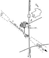
Maps & Diagrams
58N Sectional
Flight Planning
at skyvector.com
at skyvector.com