Location
Latitude: |
37-46-26.8000N (37.774111) |
Longitude: |
096-49-03.8000W (-96.817722) |
Elevation: |
1379.3 feet MSL (420 m MSL) |
Magnetic Variation: |
2.7 E (as of April 2024 from WMM2020 model) |
Time Zone: |
UTC -6.0 (Standard Time) UTC -5.0 (Daylight Savings Time) |
From City: |
03 N.M. SE of El Dorado, Kansas |
Found On: |
Kansas City Chart |
FAA Region: |
ACE |
Contacts
Manager: |
Publicly owned: |
| LARRY ARNOLD 220 E 1ST AVE EL DORADO, KS 67042 316-321-1327 |
CITY OF EL DORADO 220 E 1ST AVE EL DORADO, KS 67042 316-321-9100 |
Operations
Airport Status: |
Operational |
Facility Use: |
Public |
Type: |
Airport |
Activation Date: |
02/1944 |
Control tower: |
No |
Attendance (Months/Days/Hours): |
Months/Days/Hours ALL/MON-FRI/0700-1500 |
Boundary ARTCC: |
ZKC (Kansas City) |
Responsible ARTCC: |
ZKC (Kansas City) |
Lighting Schedule: |
SEE RMK |
Segmented Circle Indicator: |
Yes |
Traffic Pattern Altitude (MSL): |
2379 feet (725 m) |
NOTAMs Facility: |
ICT |
NOTAM-D Service: |
Yes |
International Airport of Entry: |
No |
Customs Landing Rights: |
No |
Military Landing Rights: |
Yes |
Civil/Military Joint Use: |
No |
Based Aircraft
| Single Engine: | 26 |
Annual Operations (as of 07/02/2020)
| Total Operations: | 13225 | |
| GA Local: | 9700 | 73.3% |
| GA Itinerant: | 3500 | 26.5% |
| Military Aircraft: | 25 | 0.2% |
Communications
| CTAF: | 122.800 |
| Unicom: | 122.800 |
| Approach: | WICHITA 134.8 134.8 |
| Departure: | WICHITA 134.8 134.8 |
| AWOS-3P: | 120.875 (316-322-8095) |
Fixed Based Operators (FBOs) & Fuel
(Click on a business for detail)
Please help us keep this information up to date. This is a FREE SERVICE just like everything else on Airport Guide! If you see that a business needs to be added, modified, or deleted please fill out our Update Form.
To add, modify, or delete a business click here.
Please help us keep this information up to date. This is a FREE SERVICE just like everything else on Airport Guide! If you see that a business needs to be added, modified, or deleted please fill out our Update Form.
Area Code: 316 |
| Business Name | Frequency | Phone | Fuel Grade |
|---|---|---|---|
| City of El Dorado
Update FBO info |
Unicom 122.8 | 321-1327 | 100LL, Jet A, MOGAS |
Flight Service Stations
| Primary | Alternate | |
| FSS on Field: | N | |
| FSS Name (ID): | Wichita(ICT) | |
| Frequency: | ||
| Toll Free Phone: | 1-800-WX-BRIEF |
Instrument Procedures / Charts
FAA Terminal Procedures valid from 0901Z 03/21/24 to 0901Z 04/18/24.
There are various types of charts available for an airport. They are listed in the Page Type column. Here is a legend for those types:
APD - Airport Diagram
DP - Departure Procedure Charts
HOT - Hot Spots
IAP - Instrument Approach Procedure Charts
MIN - Minimums
STAR - Standard Terminal Arrival Charts
| Page Type | Page Name | Volume | Action Since Last Cycle |
|---|---|---|---|
| IAP | RNAV (GPS) RWY 04 | NC-2 | |
| IAP | RNAV (GPS) RWY 15 | NC-2 | |
| IAP | RNAV (GPS) RWY 22 | NC-2 | |
| IAP | RNAV (GPS) RWY 33 | NC-2 | |
| MIN | TAKEOFF MINIMUMS | NC-2 |
Terminal Procedures are only available for airports in several countries with more being added all the time. If you are looking for a specific country's charts, please send an email to support(at)airportguide.com stating the country name. This will be used to prioritize the implementation.
Navigation Aids (Navaids) near EDK
| Dist (NM) | ID | Morse Code | Name | Type | Freq | True Hdg | Mag Hdg |
|---|---|---|---|---|---|---|---|
| 23.3 | IAB | . . . _ _ . . . | Mc Connell | TACAN | 116.50 | 247 | 244 |
| 27.7 | EWK | . . _ _ _ . _ | Newton | NDB | 281 | 309 | 306 |
| 30.4 | ICT | . . _ . _ . _ | Wichita | VOT | 114.00 | 254 | 251 |
| 31.1 | CA | _ . _ . . _ | Harvs | NDB | 395 | 315 | 312 |
| 32.5 | IC | . . _ . _ . | Piche | NDB | 332 | 248 | 245 |
| 36.4 | ICT | . . _ . _ . _ | Wichita | VORTAC | 113.80 | 267 | 264 |
| 38.4 | EGT | . _ _ . _ | Wellington | NDB | 414 | 225 | 222 |
| 42.4 | SO | . . . _ _ _ | Sawcy | NDB | 353 | 194 | 191 |
| 44.7 | EMP | . _ _ . _ _ . | Emporia | VORTAC | 112.80 | 45 | 43 |
| 53.6 | MPR | _ _ . _ _ . . _ . | Mc Pherson | NDB | 227 | 310 | 307 |
| 54.5 | HUT | . . . . . . _ _ | Hutchinson | VOR-DME | 116.80 | 284 | 281 |
| 55.1 | HRU | . . . . . _ . . . _ | Herington | NDB | 407 | 0 | 357 |
| 56.5 | HU | . . . . . . _ | Saltt | NDB | 404 | 292 | 289 |
| 58.5 | PN | . _ _ . _ . | Ponca | NDB | 515 | 193 | 190 |
| 58.8 | CNU | _ . _ . _ . . . _ | Chanute | VOR-DME | 109.20 | 98 | 96 |
| 60.6 | UKL | . . _ _ . _ . _ . . | Boyd | NDB | 245 | 58 | 56 |
| 63.8 | PER | . _ _ . . . _ . | Pioneer | VORTAC | 113.20 | 194 | 191 |
| 66.5 | MSB | _ _ . . . _ . . . | Monarch | NDB | 410 | 88 | 86 |
| 67.0 | SL | . . . . _ . . | Flory | NDB | 344 | 324 | 321 |
| 67.9 | BV | _ . . . . . . _ | Dewie | NDB | 201 | 145 | 143 |
Nearby Airports with Fuel
Notices to Airmen (NOTAMS)
Remarks
| A110-1 | AVOID FLT. OVER PRISON NORTH OF AIRPORT |
| A110-2 | FOR CD CTC WICHITA APCH AT 316-350-1520. |
| A110-3 | AFT HRS PHONE NMBR POSTED AT ARPT |
| A110-4 | COURTESY CAR |
| A110-5 | PILOT LOUNGE WITH COMPUTER, WIFI, TELEPHONE, RESTROOMS KEY CODE CTAF FREQ. |
| A110-6 | ARPT ADDRESS 1485 S.E. 30TH |
| A70-FUEL-10 | 0LL SELF SERVE 100 LL; SELF SERVE JET A; SELF SERVE MOGAS (AUTO GAS 91 OCTANE.) |
| A81-APT | ACTVT PAPI RWY 04 & 22, 15 & 33; HIRL 4/22 AND 15/33 - CTAF. |
| E111 | PRVDD THE APCH TO EACH RWY IS MAINTD FOR A MIN 20:1 GLIDE SLOPE AND THE TRSNL SFC BE MAINTD FOR A 7:1 SLOPE. |
Runways
Runway Summary
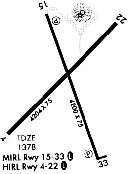
| Runways: | 04/22 15/33 |
| Longest Runway: | 04/22 is 4204 ft (1281 m) long |
| Runways with an Instrument Approach: |
EDK Airport Runway Details
| Runway 04/22 | 4204 ft x 75 ft (1281 m x 23 m) | |
| Runway Length Source: | 3RD PARTY SURVEY as of 11/08/2011 | |
| Surface: | Asphalt - Good condition - No special surface treatment | |
| Runway Edge Lights: | High Intensity | |
Runway Weight Bearing Capacity (in thousands of pounds) |
||
| Single Wheel Landing Gear: | 18.0 | |
| Dual Wheel Landing Gear: | 23.0 | |
Runway 04 |
Runway 22 |
|
Elevation: |
1375.8 | 1378.2 |
Latitude: |
37-46-12.8257N | 37-46-43.0262N |
Longitude: |
096-49-23.1915W | 096-48-47.2233W |
|
Runway True Alignment: |
043 | 223 |
Glide Path Angle: |
3.0 degrees | 3.0 degrees |
Traffic Pattern: |
Left | Left |
Runway Markings Type: |
Nonprecision Instrument | Nonprecision Instrument |
Runway Markings Condition: |
Fair | Fair |
Visual Glide Slope Indicators: |
2-Light PAPI On Left Side Of Runway | 2-Light PAPI On Left Side Of Runway |
Threshold Crossing Height: |
40 | 40 |
| Runway 15/33 | 4200 ft x 75 ft (1280 m x 23 m) | |
| Runway Length Source: | 3RD PARTY SURVEY as of 11/08/2011 | |
| Surface: | Asphalt - Good condition - No special surface treatment | |
| Runway Edge Lights: | High Intensity | |
Runway Weight Bearing Capacity (in thousands of pounds) |
||
| Single Wheel Landing Gear: | 12.5 | |
| Dual Wheel Landing Gear: | 12.5 | |
Runway 15 |
Runway 33 |
|
Elevation: |
1373.4 | 1379.3 |
Latitude: |
37-46-45.0473N | 37-46-06.3130N |
Longitude: |
096-49-11.8586W | 096-48-53.0146W |
|
Runway True Alignment: |
159 | 339 |
Glide Path Angle: |
3.0 degrees | 3.0 degrees |
Runway Markings Type: |
Nonprecision Instrument | Nonprecision Instrument |
Runway Markings Condition: |
Good | Good |
Object at End: |
TREES | |
Object Height: |
40 | |
Distance from End: |
1160 | |
Visual Glide Slope Indicators: |
2-Light PAPI On Left Side Of Runway | 2-Light PAPI On Left Side Of Runway |
Threshold Crossing Height: |
40 | 40 |
Services
Airframe Repair: |
None |
Powerplant Repair: |
None |
Bottled Oxygen: |
None |
Bulk Oxygen: |
None |
Fuel Available: |
100LL |
Parking: |
Hangars and tiedowns available |
Maps & Diagrams
EDK Sectional
Flight Planning
at skyvector.com
at skyvector.com