Location
Latitude: |
44-22-57.7000N (44.382694) |
Longitude: |
100-17-09.5000W (-100.285972) |
Elevation: |
1744.3 feet MSL (532 m MSL) |
Magnetic Variation: |
5.2 E (as of April 2024 from WMM2020 model) |
Time Zone: |
UTC -6.0 (Standard Time) UTC -5.0 (Daylight Savings Time) |
From City: |
03 N.M. E of Pierre, South Dakota |
Found On: |
Omaha Chart |
FAA Region: |
AGL |
Contacts
Manager: |
Publicly owned: |
| BRIAN COWLES 3800 AIRPORT ROAD, SUITE 209 PIERRE, SD 57501 605-773-7447 |
CITY OF PIERRE 3800 AIRPORT ROAD, SUITE 209 PIERRE, SD 57501 605-773-7447 |
Operations
Airport Status: |
Operational |
Facility Use: |
Public |
Type: |
Airport |
Activation Date: |
12/1937 |
Control tower: |
No |
Attendance (Months/Days/Hours): |
Months/Days/Hours ALL/MON-FRI/0500-2400 |
Boundary ARTCC: |
ZMP (Minneapolis) |
Responsible ARTCC: |
ZMP (Minneapolis) |
Lighting Schedule: |
SEE RMK |
Segmented Circle Indicator: |
Yes |
Traffic Pattern Altitude (MSL): |
2744 feet (836 m) |
NOTAMs Facility: |
PIR |
NOTAM-D Service: |
Yes |
International Airport of Entry: |
No |
Customs Landing Rights: |
No |
Military Landing Rights: |
Yes |
Civil/Military Joint Use: |
No |
Aircraft Rescue and Firefighting: |
Class I ARFF Index: B Air Carrier Service: Scheduled Certification Date: 05/1973 |
Based Aircraft
| Single Engine: | 50 |
| Multi Engine: | 12 |
| Jet Engine: | 1 |
| GA Helicopters: | 2 |
Annual Operations (as of 09/13/2019)
| Total Operations: | 31960 | |
| Commercial: | 1460 | 4.6% |
| Air Taxi: | 7500 | 23.5% |
| GA Local: | 7500 | 23.5% |
| GA Itinerant: | 15000 | 46.9% |
| Military Aircraft: | 500 | 1.6% |
Communications
| CTAF: | 122.700 |
| Unicom: | 122.950 |
| ASOS: | 119.025 (605-224-6087) |
- APCH/DEP SVC PRVDD BY MINNEAPOLIS ARTCC ON FREQS 125.1/269.1 (PIERRE RCAG).
Fixed Based Operators (FBOs) & Fuel
(Click on a business for detail)
Please help us keep this information up to date. This is a FREE SERVICE just like everything else on Airport Guide! If you see that a business needs to be added, modified, or deleted please fill out our Update Form.
To add, modify, or delete a business click here.
Please help us keep this information up to date. This is a FREE SERVICE just like everything else on Airport Guide! If you see that a business needs to be added, modified, or deleted please fill out our Update Form.
Area Code: 605 |
| Business Name | Frequency | Phone | Fuel Grade |
|---|---|---|---|
| Capital City Air Carrier
Update FBO info |
Unicom 122.95 | 224-9000 | 100LL, Jet A |
Flight Service Stations
| Primary | Alternate | |
| FSS on Field: | N | |
| FSS Name (ID): | Huron(HON) | |
| Frequency: | ||
| Toll Free Phone: | 1-800-WX-BRIEF |
Instrument Procedures / Charts
FAA Terminal Procedures valid from 0901Z 03/21/24 to 0901Z 04/18/24.
There are various types of charts available for an airport. They are listed in the Page Type column. Here is a legend for those types:
APD - Airport Diagram
DP - Departure Procedure Charts
HOT - Hot Spots
IAP - Instrument Approach Procedure Charts
MIN - Minimums
STAR - Standard Terminal Arrival Charts
| Page Type | Page Name | Volume | Action Since Last Cycle |
|---|---|---|---|
| APD | AIRPORT DIAGRAM | NC-1 | |
| IAP | ILS OR LOC RWY 31 | NC-1 | |
| IAP | RNAV (GPS) RWY 07 | NC-1 | |
| IAP | RNAV (GPS) RWY 13 | NC-1 | |
| IAP | RNAV (GPS) RWY 25 | NC-1 | |
| IAP | RNAV (GPS) RWY 31 | NC-1 | |
| IAP | VOR OR TACAN RWY 25 | NC-1 | |
| IAP | VOR/DME OR TACAN RWY 07 | NC-1 | |
| MIN | ALTERNATE MINIMUMS | NC-1 | |
| MIN | TAKEOFF MINIMUMS | NC-1 |
Terminal Procedures are only available for airports in several countries with more being added all the time. If you are looking for a specific country's charts, please send an email to support(at)airportguide.com stating the country name. This will be used to prioritize the implementation.
Navigation Aids (Navaids) near PIR
| Dist (NM) | ID | Morse Code | Name | Type | Freq | True Hdg | Mag Hdg |
|---|---|---|---|---|---|---|---|
| 5.3 | PIR | . _ _ . . . . _ . | Pierre | VORTAC | 113.75 | 82 | 77 |
| 58.3 | ISD | . . . . . _ . . | Winner | VOR | 112.80 | 156 | 151 |
| 62.4 | PHP | . _ _ . . . . . . _ _ . | Philip | VOR-DME | 108.40 | 252 | 246 |
| 73.8 | DPR | _ . . . _ _ . . _ . | Dupree | VOR-DME | 116.80 | 304 | 298 |
| 83.6 | HO | . . . . _ _ _ | Beady | NDB | 302 | 86 | 82 |
| 84.7 | HON | . . . . _ _ _ _ . | Huron | DME | 117.6 | 86 | 82 |
| 92.0 | VTN | . . . _ _ _ . | Valentine | NDB | 314 | 187 | 182 |
Nearby Airports with Fuel
| Dist (NM) | Name (Airport IDs) | True Hdg | Mag Hdg | Fuel Grade |
|---|---|---|---|---|
| 38.9 | Gettysburg Municipal Airport (0D8) |
21 | 16 | 100LL, Jet A |
| 55.7 | Chamberlain Municipal Airport (9V9) |
131 | 127 | 100LL, Jet A |
| 57.5 | Miller Municipal Airport (KMKA MKA) |
80 | 76 | 100LL |
| 59.9 | Philip Airport (PHP KPHP PHP) |
250 | 244 | 100LL |
| 63.4 | Faulkton Municipal Airport (3FU) |
51 | 47 | 100LL |
| 70.0 | Mobridge Municipal Airport (MBG KMBG MBG) |
355 | 350 | 100LL, Jet A, MOGAS |
| 70.6 | Timber Lake Municipal Airport (D58) |
331 | 325 | 100LL |
| 79.4 | Gregory Municipal - Flynn Field Airport (9D1) |
150 | 146 | 100LL, Jet A |
| 86.0 | Platte Municipal Airport (1D3) |
132 | 128 | 100LL |
| 88.2 | Huron Regional Airport (HON KHON HON) |
89 | 85 | 100LL, Jet A |
| 92.3 | Miller Field Airport (VTN KVTN VTN) |
187 | 182 | 100LL, Jet A |
Notices to Airmen (NOTAMS)
Remarks
| A110-1 | BIRDS ON & INVOF ARPT & WITHIN A 25 NM RADIUS. |
| A110-2 | TWY C IS 50 FT WIDE & RSTRD TO ACFT 75000 LBS OR LESS. |
| A110-4 | NO LINE OF SIGHT BTN RY ENDS OF RY 07/25. |
| A110-6 | ARPT COND UNMONITORED DURING 2200-0600 MON-FRI; 1300 SAT - 1300 SUN. |
| A110-7 | AIR CARRIER LANDING FEE $14 + $1 PER 1000 LBS OVER 20K LBS |
| A110-8 | FOR CD IF UNA TO CTC ON FSS FREQ, CTC MINNEAPOLIS ARTCC AT 651-463-5588. |
| A17 | FOR ATTENDANT OTHER TIMES CALL 605-224-9000/8621. |
| A24 | NO |
| A26 | 48 HOUR PPR FOR UNSKED ACR OPNS INVOLVING ACFT DESIGNED FOR 31 OR MORE PAX SEATS CALL 605-773-7447 OR 605-773-7405. |
| A81-APT | ACTVT MALSR RWY 31; REIL RWY 07, 13, 25; PAPI RWY 07, 25, 13 & 31; HIRL RWY 07/25 & 13/31 -CTAF. |
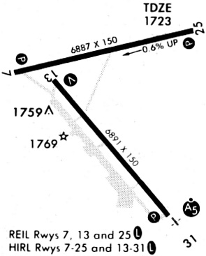
Runways
Runway Summary
| Runways: | 07/25 13/31 |
| Longest Runway: | 13/31 is 6900 ft (2103 m) long |
| Runways with an Instrument Approach: | 31 |
PIR Airport Runway Details
| Runway 07/25 | 6880 ft x 150 ft (2097 m x 46 m) | |
| Runway Length Source: | 3RD PARTY SURVEY as of 01/18/2017 | |
| Surface: | Asphalt - Good condition - Saw-cut or plastic grooved | |
| Runway Pavement Class: | 58 /F/C/W/T | |
| Runway Edge Lights: | High Intensity | |
Runway Weight Bearing Capacity (in thousands of pounds) |
||
| Single Wheel Landing Gear: | 91.0 | |
| Dual Wheel Landing Gear: | 114.0 | |
| Dual Tandem Wheel Landing Gear: | 180.0 | |
Runway 07 |
Runway 25 |
|
Elevation: |
1744.3 | 1702.6 |
Latitude: |
44-23-08.6056N | 44-23-23.6979N |
Longitude: |
100-17-57.5957W | 100-16-25.2256W |
|
Runway True Alignment: |
077 | 257 |
Glide Path Angle: |
3.0 degrees | 3.0 degrees |
Traffic Pattern: |
Left | Left |
Runway Markings Type: |
Nonprecision Instrument | Nonprecision Instrument |
Runway Markings Condition: |
Good | Good |
Object at End: |
TANK | |
Object Height: |
79 | |
Object Marked/Lighted?: |
Lighted | |
Distance from End: |
3158 | |
Object Centerline Offset: |
548 ft. left of centerline | |
Visual Glide Slope Indicators: |
4-Light PAPI On Left Side Of Runway | 4-Light PAPI On Left Side Of Runway |
REIL: |
Yes | Yes |
Touchdown Lights: |
No | No |
Centerline Lights: |
No | No |
Threshold Crossing Height: |
46 | 53 |
Declared Distances |
||
Take Off Run Avbl. (TORA): |
6880 | 6880 |
Take Off Distance Avbl. (TODA): |
6880 | 6880 |
Actual Stop Dist. Avbl. (ASDA): |
6830 | 6880 |
Landing Dist. Avbl. (LDA): |
6830 | 6880 |
| Runway 13/31 | 6900 ft x 100 ft (2103 m x 30 m) | |
| Runway Length Source: | 3RD PARTY SURVEY as of 01/18/2017 | |
| Surface: | Asphalt - Good condition - Saw-cut or plastic grooved | |
| Runway Pavement Class: | 51 /F/C/W/T | |
| Runway Edge Lights: | High Intensity | |
Runway Weight Bearing Capacity (in thousands of pounds) |
||
| Single Wheel Landing Gear: | 91.0 | |
| Dual Wheel Landing Gear: | 108.0 | |
| Dual Tandem Wheel Landing Gear: | 168.0 | |
Runway 13 |
Runway 31 |
|
Elevation: |
1730.8 | 1717.7 |
Latitude: |
44-23-05.5867N | 44-22-12.9046N |
Longitude: |
100-17-37.7384W | 100-16-37.5043W |
|
Runway True Alignment: |
141 | 321 |
ILS Type: |
ILS/DME | |
Glide Path Angle: |
3.0 degrees | 3.0 degrees |
Traffic Pattern: |
Left | Left |
Runway Markings Type: |
Precision Instrument | Precision Instrument |
Runway Markings Condition: |
Good | Good |
Object Centerline Offset: |
548 ft. left of centerline | |
Visual Glide Slope Indicators: |
4-Light PAPI On Left Side Of Runway | 4-Light PAPI On Left Side Of Runway |
Approach Light System: |
1,400 Foot Medium Intensity Approach Lighting System With Runway Alignment Indicator Lights | |
REIL: |
Yes | No |
Touchdown Lights: |
No | No |
Centerline Lights: |
No | No |
Threshold Crossing Height: |
52 | 55 |
Declared Distances |
||
Take Off Run Avbl. (TORA): |
6900 | 6900 |
Take Off Distance Avbl. (TODA): |
6900 | 6900 |
Actual Stop Dist. Avbl. (ASDA): |
6900 | 6900 |
Landing Dist. Avbl. (LDA): |
6900 | 6900 |
Services
Airframe Repair: |
Major |
Powerplant Repair: |
Major |
Bottled Oxygen: |
None |
Bulk Oxygen: |
None |
Fuel Available: |
100LL, Jet A |
Landing Fees: |
No |
Parking: |
Tiedowns available |
Maps & Diagrams
PIR Sectional
Flight Planning
at skyvector.com
at skyvector.com