Location
Latitude: |
32-50-03.2000N (32.834222) |
Longitude: |
115-34-43.5000W (-115.57875) |
Elevation: |
-53.6 feet MSL (-16 m MSL) |
Magnetic Variation: |
10.6 E (as of April 2024 from WMM2020 model) |
Time Zone: |
UTC -8.0 (Standard Time) UTC -7.0 (Daylight Savings Time) |
From City: |
01 N.M. S of Imperial, California |
Found On: |
Phoenix Chart |
FAA Region: |
AWP |
Contacts
Manager: |
Publicly owned: |
| JENELL GUERRERO 1099 AIRPORT ROAD IMPERIAL, CA 92251 442-265-3220 |
IMPERIAL COUNTY 1099 AIRPORT ROAD IMPERIAL, CA 92251 442-265-1001 |
Operations
Airport Status: |
Operational |
Facility Use: |
Public |
Type: |
Airport |
Activation Date: |
04/1940 |
Control tower: |
No |
Attendance (Months/Days/Hours): |
Months/Days/Hours ALL/ALL/0700-1630 |
Boundary ARTCC: |
ZLA (Los Angeles) |
Responsible ARTCC: |
ZLA (Los Angeles) |
Lighting Schedule: |
SEE RMK |
Segmented Circle Indicator: |
Yes |
Traffic Pattern Altitude (MSL): |
946 feet (288 m) |
NOTAMs Facility: |
IPL |
NOTAM-D Service: |
Yes |
International Airport of Entry: |
No |
Customs Landing Rights: |
No |
Military Landing Rights: |
Yes |
Civil/Military Joint Use: |
No |
Aircraft Rescue and Firefighting: |
Class III ARFF Index: A Air Carrier Service: Scheduled Certification Date: 12/2005 |
Based Aircraft
| Single Engine: | 28 |
| Multi Engine: | 2 |
| GA Helicopters: | 2 |
Annual Operations (as of 12/31/2022)
| Total Operations: | 6429 | |
| Commercial: | 855 | 13.3% |
| Air Taxi: | 319 | 5.0% |
| GA Local: | 1100 | 17.1% |
| GA Itinerant: | 493 | 7.7% |
| Military Aircraft: | 3662 | 57.0% |
Communications
| CTAF: | 122.700 |
| Unicom: | 122.700 |
| ASOS: | 132.175 (760-355-2851) |
- APCH/DEP CTL SVC PRVDD BY YUMA CERAP ON 128.55/292.2 (EL CENTRO RCAG).
Fixed Based Operators (FBOs) & Fuel
(Click on a business for detail)
Please help us keep this information up to date. This is a FREE SERVICE just like everything else on Airport Guide! If you see that a business needs to be added, modified, or deleted please fill out our Update Form.
To add, modify, or delete a business click here.
Please help us keep this information up to date. This is a FREE SERVICE just like everything else on Airport Guide! If you see that a business needs to be added, modified, or deleted please fill out our Update Form.
Area Code: 760 |
| Business Name | Frequency | Phone | Fuel Grade |
|---|---|---|---|
| I.V. Aviation
Update FBO info |
355-1700 | ||
| Imperial Flying Service
Update FBO info |
Unicom 122.7 | 353-1375, after hours call 355-2833 or 370-0148 | 100LL, Jet A |
Flight Service Stations
| Primary | Alternate | |
| FSS on Field: | N | |
| FSS Name (ID): | San Diego(SAN) | |
| Frequency: | ||
| Toll Free Phone: | 1-800-WX-BRIEF |
Instrument Procedures / Charts
FAA Terminal Procedures valid from 0901Z 03/21/24 to 0901Z 04/18/24.
There are various types of charts available for an airport. They are listed in the Page Type column. Here is a legend for those types:
APD - Airport Diagram
DP - Departure Procedure Charts
HOT - Hot Spots
IAP - Instrument Approach Procedure Charts
MIN - Minimums
STAR - Standard Terminal Arrival Charts
| Page Type | Page Name | Volume | Action Since Last Cycle |
|---|---|---|---|
| APD | AIRPORT DIAGRAM | SW-3 | |
| IAP | VOR OR GPS-A | SW-3 | |
| MIN | ALTERNATE MINIMUMS | SW-3 | |
| MIN | TAKEOFF MINIMUMS | SW-3 |
Terminal Procedures are only available for airports in several countries with more being added all the time. If you are looking for a specific country's charts, please send an email to support(at)airportguide.com stating the country name. This will be used to prioritize the implementation.
Navigation Aids (Navaids) near IPL
| Dist (NM) | ID | Morse Code | Name | Type | Freq | True Hdg | Mag Hdg |
|---|---|---|---|---|---|---|---|
| 5.2 | NJK | _ . . _ _ _ _ . _ | El Centro | TACAN | 111.00 | 268 | 257 |
| 6.2 | IPL | . . . _ _ . . _ . . | Imperial | VORTAC | 115.90 | 145 | 134 |
| 21.1 | MXL | Mexicali | VOR-DME | 115.00 | 125 | 114 | |
| 49.4 | BZA | _ . . . _ _ . . . _ | Bard | VORTAC | 116.80 | 94 | 84 |
| 50.0 | NYL | _ . _ . _ _ . _ . . | Yuma | TACAN | 113.70 | 102 | 92 |
| 53.9 | JLI | . _ _ _ . _ . . . . | Julian | VORTAC | 114.00 | 290 | 279 |
| 55.9 | TRM | _ . _ . _ _ | Thermal | VORTAC | 116.20 | 328 | 317 |
| 61.4 | BLH | _ . . . . _ . . . . . . | Blythe | VORTAC | 117.40 | 41 | 30 |
| 70.4 | SEE | . . . . . | Gillespie Field | VOT | 110.00 | 269 | 258 |
| 71.6 | TIJ | _ . . . _ _ _ | Tijuana | VOR-DME | 116.50 | 256 | 245 |
| 72.0 | PGY | . _ _ . _ _ . _ . _ _ | Poggi | VORTAC | 116.45 | 259 | 248 |
| 75.4 | PSP | . _ _ . . . . . _ _ . | Palm Springs | VORTAC | 115.50 | 325 | 314 |
| 77.3 | TNP | _ _ . . _ _ . | Twentynine Palms | VORTAC | 114.20 | 352 | 341 |
| 79.0 | NRS | _ . . _ . . . . | Imperial Beach | TACAN | 109.20 | 258 | 247 |
| 79.5 | NKX | _ . _ . _ _ . . _ | Miramar | TACAN | 109.60 | 271 | 260 |
| 81.2 | ENS | Ensenada | NDB | 400 | 220 | 209 | |
| 83.0 | NZY | _ . _ _ . . _ . _ _ | North Island | TACAN | 117.00 | 264 | 253 |
| 83.1 | MZB | _ _ _ _ . . _ . . . | Mission Bay | VORTAC | 117.80 | 268 | 257 |
| 84.4 | SAN | . . . . _ _ . | Mount Soledad | VOT | 109.00 | 270 | 259 |
| 88.3 | PKE | . _ _ . _ . _ . | Parker | VORTAC | 117.90 | 30 | 19 |
Nearby Airports with Fuel
Notices to Airmen (NOTAMS)
Remarks
| A110-12 | PPR FOR NON-SKEDD AIR CARRIER ARFF SER, CONTACT AMER 442-264-3220. |
| A110-15 | TWY C3 CLSD BTN RWY 14/32 AND TWY C5. |
| A110-16 | NOISE ABATEMENT: NOISE SENSITIVE AREA NE EDGE OF AP: SCHOOLS AND RESIDENTIAL. CONDS PMTG, HEL ARRS SHOULD BE TO RWY 32, TOUCHDOWN MIDFIELD (BTN TWY A4 AND A3). HEL DEPARTURES SHOULD BE FM RWY 14 MIDFIELD. WHEN CONDS REQ RWY 32 DEPARTURE, MNTN RWY CNTRLN FOR 1.5 NM BEFORE INITIATING TURN. FOR HEL TRNG PATS/AUTOROTATIONS USE RWY 08/26, MAX OF 3 CIRCUITS. BTN SS-SR AVOID CONS PAT CIRCUITS. |
| A110-17 | FOR CD CTC YUMA CERAP AT 928-269-9569. |
| A110-2 | AVOID NAF EL CENTRO TFC; ACFT DEPG RWY 26 MAKE IMT RIGHT TURN - STAY BELOW 1000 FT; CTC NAF TWR 119.1 FOR ADZY. |
| A110-3 | FRQ HIGH-SPD MIL JET TFC TRANSITS IMPERIAL COUNTY TFC AREA WB DESCENDING VFR TO NAF EL CENRTO. AVOID 2500 FT TO 3500 FT MSL NEAR IMPERIAL COUNTY. CTC NAF TWR 119.1 FOR NAVY TFC ADZY. |
| A110-9 | RADIO ANT +70 FT LCTD ON CTL TWR AT MIDFIELD RWY 14/32 AND 500 FT WEST RWY CNTRLN. |
| A24 | OVERNIGHT TIE-DOWN FEE. |
| A26 | RWY 8/26 NOT AVBL FOR SKED ACR OPNS WITH MORE THAN 9 PSGR SEATS OR UNSKED ACR AT LEAST 31 PSGR SEATS. |
| A81-APT | ACTVT MIRL RWYS 08/26 & 14/32 - CTAF. |
Runways
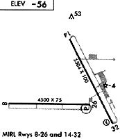
Runway Summary
| Runways: | 08/26 14/32 |
| Longest Runway: | 14/32 is 5308 ft (1618 m) long |
| Runways with an Instrument Approach: |
IPL Airport Runway Details
| Runway 08/26 | 4501 ft x 75 ft (1372 m x 23 m) | |
| Runway Length Source: | 3RD PARTY SURVEY as of 06/29/2012 | |
| Surface: | Asphalt - Good condition - No special surface treatment | |
| Runway Pavement Class: | 6 /F/D/W/T | |
| Runway Edge Lights: | Medium Intensity | |
Runway Weight Bearing Capacity (in thousands of pounds) |
||
| Single Wheel Landing Gear: | 50.0 | |
| Dual Wheel Landing Gear: | 50.0 | |
Runway 08 |
Runway 26 |
|
Elevation: |
-55.1 | -55.0 |
Latitude: |
32-49-55.5760N | 32-49-55.5994N |
Longitude: |
115-35-24.4371W | 115-34-31.7016W |
|
Runway True Alignment: |
090 | 270 |
Glide Path Angle: |
3.0 degrees | 3.0 degrees |
Traffic Pattern: |
Right | |
Runway Markings Type: |
Basic | Basic |
Runway Markings Condition: |
Good | Good |
Object at End: |
PLINE | POLE |
Object Height: |
59 | 32 |
Distance from End: |
1600 | 1575 |
Object Centerline Offset: |
0 ft. left and right of centerline | 250 ft. right of centerline |
Visual Glide Slope Indicators: |
4-Light PAPI On Left Side Of Runway | 4-Light PAPI On Left Side Of Runway |
Threshold Crossing Height: |
45 | 45 |
Declared Distances |
||
Take Off Run Avbl. (TORA): |
4501 | 4501 |
Take Off Distance Avbl. (TODA): |
4501 | 4501 |
Actual Stop Dist. Avbl. (ASDA): |
4501 | 4501 |
Landing Dist. Avbl. (LDA): |
4501 | 4501 |
| Runway 14/32 | 5308 ft x 100 ft (1618 m x 30 m) | |
| Runway Length Source: | 3RD PARTY SURVEY as of 06/29/2012 | |
| Surface: | Asphalt - Good condition - Porous friction course | |
| Runway Pavement Class: | 26 /F/C/W/T | |
| Runway Edge Lights: | Medium Intensity | |
Runway Weight Bearing Capacity (in thousands of pounds) |
||
| Single Wheel Landing Gear: | 60.0 | |
| Dual Wheel Landing Gear: | 80.0 | |
| Dual Tandem Wheel Landing Gear: | 102.0 | |
| Dual Dual Tandem Wheel Landing Gear: | 130.0 | |
Runway 14 |
Runway 32 |
|
Elevation: |
-55.1 | -53.9 |
Latitude: |
32-50-33.0441N | 32-49-46.3804N |
Longitude: |
115-34-45.4508W | 115-34-16.9123W |
|
Runway True Alignment: |
153 | 333 |
Glide Path Angle: |
3.0 degrees | 3.0 degrees |
Traffic Pattern: |
Left | Right |
Runway Markings Type: |
Nonprecision Instrument | Nonprecision Instrument |
Runway Markings Condition: |
Good | Good |
Object at End: |
FENCE | ROAD |
Object Height: |
9 | 15 |
Object Marked/Lighted?: |
Lighted | |
Distance from End: |
425 | 600 |
Object Centerline Offset: |
0 ft. left and right of centerline | 250 ft. right of centerline |
Visual Glide Slope Indicators: |
4-Light PAPI On Left Side Of Runway | 4-Light PAPI On Left Side Of Runway |
REIL: |
No | No |
Touchdown Lights: |
No | No |
Centerline Lights: |
No | No |
Threshold Crossing Height: |
45 | 45 |
Declared Distances |
||
Take Off Run Avbl. (TORA): |
5304 | 5304 |
Take Off Distance Avbl. (TODA): |
5304 | 5304 |
Actual Stop Dist. Avbl. (ASDA): |
5304 | 5304 |
Landing Dist. Avbl. (LDA): |
5304 | 5304 |
Services
Airframe Repair: |
Minor |
Powerplant Repair: |
Major |
Bottled Oxygen: |
None |
Bulk Oxygen: |
None |
Fuel Available: |
100LL, Jet A |
Landing Fees: |
No |
Parking: |
Tiedowns available |
Maps & Diagrams
IPL Sectional
Flight Planning
at skyvector.com
at skyvector.com