Location
Latitude: |
38-49-16.5000N (38.82125) |
Longitude: |
094-36-34.3000W (-94.609528) |
Elevation: |
1025.0 feet MSL (312 m MSL) |
Magnetic Variation: |
1.2 E (as of April 2024 from WMM2020 model) |
Time Zone: |
UTC -6.0 (Standard Time) UTC -5.0 (Daylight Savings Time) |
From City: |
04 N.M. NE of Stilwell, Kansas |
Found On: |
Kansas City Chart |
FAA Region: |
ACE |
Contacts
Manager: |
Privately owned: |
| WILLIAM C. SHELDON 16935 S. KENNETH RD STILWELL, KS 66085 913-897-2647 |
W. SHELDON/TOM TIETZE 16885 S. KENNETH RD STILWELL, KS 66085 |
Operations
Airport Status: |
Operational |
Facility Use: |
Public |
Type: |
Airport |
Activation Date: |
01/1956 |
Control tower: |
No |
Attendance (Months/Days/Hours): |
Months/Days/Hours Unattended |
Boundary ARTCC: |
ZKC (Kansas City) |
Responsible ARTCC: |
ZKC (Kansas City) |
Segmented Circle Indicator: |
No |
Traffic Pattern Altitude (MSL): |
2025 feet (617 m) |
NOTAMs Facility: |
COU |
NOTAM-D Service: |
Yes |
Based Aircraft
| Single Engine: | 4 |
| Ultralights: | 1 |
Annual Operations (as of 07/31/2019)
| Total Operations: | 1000 | |
| GA Local: | 650 | 65.0% |
| GA Itinerant: | 350 | 35.0% |
Communications
| CTAF: | 122.900 |
Fixed Based Operators (FBOs) & Fuel
(Click on a business for detail)
Please help us keep this information up to date. This is a FREE SERVICE just like everything else on Airport Guide! If you see that a business needs to be added, modified, or deleted please fill out our Update Form.
To add, modify, or delete a business click here.
Please help us keep this information up to date. This is a FREE SERVICE just like everything else on Airport Guide! If you see that a business needs to be added, modified, or deleted please fill out our Update Form.
Area Code: 913 |
| Business Name | Frequency | Phone | Fuel Grade |
|---|
Flight Service Stations
| Primary | Alternate | |
| FSS on Field: | N | |
| FSS Name (ID): | Columbia(COU) | |
| Frequency: | ||
| Toll Free Phone: | 1-800-WX-BRIEF |
Instrument Procedures / Charts
Terminal Procedures are only available for airports in several countries with more being added all the time. If you are looking for a specific country's charts, please send an email to support(at)airportguide.com stating the country name. This will be used to prioritize the implementation.
Navigation Aids (Navaids) near 63K
| Dist (NM) | ID | Morse Code | Name | Type | Freq | True Hdg | Mag Hdg |
|---|---|---|---|---|---|---|---|
| 6.1 | OJC | _ _ _ . _ _ _ _ . _ . | Johnson County | VOR-DME | 113.00 | 281 | 280 |
| 7.2 | PK | . _ _ . _ . _ | Herbb | NDB | 420 | 235 | 234 |
| 14.6 | GQ | _ _ . _ _ . _ | Norge | NDB | 517 | 351 | 350 |
| 18.0 | RIS | . _ . . . . . . | Riverside | VOR-DME | 111.40 | 1 | 360 |
| 18.1 | MKC | _ _ _ . _ _ . _ . | Kansas City Downtown | VOT | 108.60 | 1 | 360 |
| 24.9 | DO | _ . . _ _ _ | Dotte | NDB | 359 | 344 | 343 |
| 26.0 | JZ | . _ _ _ _ _ . . | Newbn | NDB | 338 | 282 | 281 |
| 27.8 | ANX | . _ _ . _ . . _ | Napoleon | VORTAC | 114.00 | 53 | 52 |
| 28.5 | MCI | _ _ _ . _ . . . | Kansas City | VORTAC | 113.25 | 347 | 346 |
| 33.4 | BUM | _ . . . . . _ _ _ | Butler | VORTAC | 115.90 | 170 | 169 |
| 45.6 | FO | . . _ . _ _ _ | Riply | NDB | 326 | 275 | 273 |
| 47.7 | TOP | _ _ _ _ . _ _ . | Topeka | VORTAC | 117.80 | 293 | 291 |
| 49.7 | FOE | . . _ . _ _ _ . | Forbes | TACAN | 111.60 | 279 | 277 |
| 49.8 | SZL | . . . _ _ . . . _ . . | Whiteman | TACAN | 109.80 | 95 | 94 |
| 50.0 | FOE | . . _ . _ _ _ . | Forbes | VOT | 111.00 | 279 | 277 |
| 51.5 | GLY | _ _ . . _ . . _ . _ _ | Golden Valley | NDB | 388 | 122 | 121 |
| 53.1 | ST | . . . _ | Tario | NDB | 260 | 345 | 344 |
| 53.4 | TO | _ _ _ _ | Biloy | NDB | 521 | 289 | 287 |
| 59.4 | BQS | _ . . . _ _ . _ . . . | Braymer | VOR-DME | 115.35 | 34 | 33 |
| 60.8 | UKL | . . _ _ . _ . _ . . | Boyd | NDB | 245 | 239 | 237 |
Nearby Airports with Fuel
Notices to Airmen (NOTAMS)
Remarks
| A110-1 | WILDLIFE ON & INVOF ARPT. |
| A110-2 | TREES AND UNEVEN TERRAIN BOTH SIDES OF RWY. TREES IN APCH ZONES. |
| A110-3 | +10 EARTH EMBANKMENT MID FLD, WEST DGE OF RWY. |
| A110-4 | FOR CD CTC KANSAS CITY APCH AT 816-329-2710. |
| A33-17/35 | RWY ROUGH 550 FT FM AER 35. |
| A75 | TURF TIE DOWN AREA AVBL; BRING OWN ANCHORS AND CHAINS. |
| E111 | EXISTED PRIOR TO 1959. |
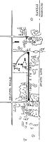
Runways
Runway Summary
| Runways: | 17/35 |
| Longest Runway: | 17/35 is 2000 ft (610 m) long |
| Runways with an Instrument Approach: |
63K Airport Runway Details
| Runway 17/35 | 2000 ft x 56 ft (610 m x 17 m) | |
| Surface: | Turf/Gravel - Fair condition - No special surface treatment | |
Runway 17 |
Runway 35 |
|
Elevation: |
1019.0 | 1010.0 |
Latitude: |
38-49-26.3400N | 38-49-06.5700N |
Longitude: |
094-36-34.2900W | 094-36-34.3600W |
|
Runway True Alignment: |
180 | 360 |
Glide Path Angle: |
0.0 degrees | 0.0 degrees |
Traffic Pattern: |
Right | Left |
Object at End: |
TREES | TREES |
Object Height: |
51 | 33 |
Distance from End: |
149 | 197 |
Object Centerline Offset: |
58 ft. right of centerline | 92 ft. right of centerline |
Displaced Threshold: |
150 | |
Threshold Latitude: |
38-49-08.0526N | |
Threshold Longitude: |
094-36-34.3548W |
Services
Airframe Repair: |
None |
Powerplant Repair: |
None |
Bottled Oxygen: |
None |
Bulk Oxygen: |
None |
Fuel Available: |
100LL |
Landing Fees: |
No |
Parking: |
Tiedowns available |
Maps & Diagrams
63K Sectional
Flight Planning
at skyvector.com
at skyvector.com