Location
Latitude: |
38-57-32.7480N (38.959097) |
Longitude: |
094-22-18.8210W (-94.371895) |
Elevation: |
1004.1 feet MSL (306 m MSL) |
Magnetic Variation: |
1.1 E (as of May 2024 from WMM2020 model) |
Time Zone: |
UTC -6.0 (Standard Time) UTC -5.0 (Daylight Savings Time) |
From City: |
03 N.M. N of Lee's Summit, Missouri |
Found On: |
Kansas City Chart |
FAA Region: |
ACE |
Contacts
Manager: |
Publicly owned: |
| JOEL ARRINGTON 2751 NE DOUGLAS RD LEES SUMMIT, MO 64064 816-969-1186 |
CITY OF LEE'S SUMMIT 220 SE GREEN, P.O. BOX 1600 LEES SUMMIT, MO 64063 816-969-1000 |
Operations
Airport Status: |
Operational |
Facility Use: |
Public |
Type: |
Airport |
Activation Date: |
04/1972 |
Control tower: |
No |
Attendance (Months/Days/Hours): |
Months/Days/Hours ALL/ALL/0600-2000 |
Boundary ARTCC: |
ZKC (Kansas City) |
Responsible ARTCC: |
ZKC (Kansas City) |
Lighting Schedule: |
SEE RMK |
Segmented Circle Indicator: |
Yes |
Traffic Pattern Altitude (MSL): |
2004 feet (611 m) |
NOTAMs Facility: |
LXT |
NOTAM-D Service: |
Yes |
International Airport of Entry: |
No |
Customs Landing Rights: |
No |
Military Landing Rights: |
Yes |
Civil/Military Joint Use: |
No |
Based Aircraft
| Single Engine: | 115 |
| Multi Engine: | 9 |
| Jet Engine: | 6 |
| GA Helicopters: | 2 |
Annual Operations (as of 12/31/2020)
| Total Operations: | 52500 | |
| Air Taxi: | 1750 | 3.3% |
| GA Local: | 34850 | 66.4% |
| GA Itinerant: | 15150 | 28.9% |
| Military Aircraft: | 750 | 1.4% |
Communications
| CTAF: | 122.800 |
| Unicom: | 122.800 |
| Approach: | KANSAS CITY |
| Departure: | KANSAS CITY |
| ASOS: | 124.175 (816-347-9807) |
Fixed Based Operators (FBOs) & Fuel
(Click on a business for detail)
Please help us keep this information up to date. This is a FREE SERVICE just like everything else on Airport Guide! If you see that a business needs to be added, modified, or deleted please fill out our Update Form.
To add, modify, or delete a business click here.
Please help us keep this information up to date. This is a FREE SERVICE just like everything else on Airport Guide! If you see that a business needs to be added, modified, or deleted please fill out our Update Form.
Area Code: 816 |
| Business Name | Frequency | Phone | Fuel Grade |
|---|---|---|---|
| Air Charter
Update FBO info |
Unicom 122.8 | 525-3330 | |
| Lee's Summit Muni Airport
Update FBO info |
969-7492 | 100LL, Jet A (Avfuel) MOGAS (independent) | |
| Midwest Executive Aircraft, Inc.
Update FBO info |
Unicom 122.8 | 246-4560 |
Flight Service Stations
| Primary | Alternate | |
| FSS on Field: | N | |
| FSS Name (ID): | Columbia(COU) | |
| Frequency: | ||
| Toll Free Phone: | 1-800-WX-BRIEF |
Instrument Procedures / Charts
FAA Terminal Procedures valid from 0901Z 03/21/24 to 0901Z 04/18/24.
There are various types of charts available for an airport. They are listed in the Page Type column. Here is a legend for those types:
APD - Airport Diagram
DP - Departure Procedure Charts
HOT - Hot Spots
IAP - Instrument Approach Procedure Charts
MIN - Minimums
STAR - Standard Terminal Arrival Charts
| Page Type | Page Name | Volume | Action Since Last Cycle |
|---|---|---|---|
| APD | AIRPORT DIAGRAM | NC-3 | Changed |
| DP | CHIEF NINE | NC-3 | |
| DP | LAKES FIVE | NC-3 | |
| DP | RACER EIGHT | NC-3 | |
| DP | ROYAL ONE | NC-3 | |
| DP | TIFTO EIGHT | NC-3 | |
| DP | WILDCAT SIX | NC-3 | |
| IAP | RNAV (GPS) RWY 11 | NC-3 | |
| IAP | RNAV (GPS) RWY 18 | NC-3 | |
| IAP | RNAV (GPS) RWY 29 | NC-3 | |
| IAP | RNAV (GPS) RWY 36 | NC-3 | |
| IAP | VOR-A | NC-3 | |
| MIN | ALTERNATE MINIMUMS | NC-3 | |
| MIN | TAKEOFF MINIMUMS | NC-3 | |
| STAR | BRAYMER EIGHT | NC-3 | |
| STAR | BRAYMER EIGHT[DELIMITER] CONT.1 | NC-3 | |
| STAR | JHAWK SEVEN | NC-3 | |
| STAR | TYGER SEVEN | NC-3 | |
| STAR | TYGER SEVEN[DELIMITER] CONT.1 | NC-3 |
Terminal Procedures are only available for airports in several countries with more being added all the time. If you are looking for a specific country's charts, please send an email to support(at)airportguide.com stating the country name. This will be used to prioritize the implementation.
Navigation Aids (Navaids) near KLXT
| Dist (NM) | ID | Morse Code | Name | Type | Freq | True Hdg | Mag Hdg |
|---|---|---|---|---|---|---|---|
| 14.0 | ANX | . _ _ . _ . . _ | Napoleon | VORTAC | 114.00 | 54 | 53 |
| 14.3 | RIS | . _ . . . . . . | Riverside | VOR-DME | 111.40 | 312 | 311 |
| 14.4 | MKC | _ _ _ . _ _ . _ . | Kansas City Downtown | VOT | 108.60 | 313 | 312 |
| 14.6 | GQ | _ _ . _ _ . _ | Norge | NDB | 517 | 294 | 293 |
| 18.5 | OJC | _ _ _ . _ _ _ _ . _ . | Johnson County | VOR-DME | 113.00 | 247 | 246 |
| 21.1 | PK | . _ _ . _ . _ | Herbb | NDB | 420 | 234 | 233 |
| 23.6 | DO | _ . . _ _ _ | Dotte | NDB | 359 | 311 | 310 |
| 25.9 | MCI | _ _ _ . _ . . . | Kansas City | VORTAC | 113.25 | 319 | 318 |
| 36.6 | JZ | . _ _ _ _ _ . . | Newbn | NDB | 338 | 265 | 264 |
| 40.7 | SZL | . . . _ _ . . . _ . . | Whiteman | TACAN | 109.80 | 108 | 107 |
| 41.6 | BUM | _ . . . . . _ _ _ | Butler | VORTAC | 115.90 | 187 | 186 |
| 46.4 | BQS | _ . . . _ _ . _ . . . | Braymer | VOR-DME | 115.35 | 29 | 28 |
| 48.3 | GLY | _ _ . . _ . . _ . _ _ | Golden Valley | NDB | 388 | 137 | 136 |
| 49.7 | ST | . . . _ | Tario | NDB | 260 | 330 | 329 |
| 55.1 | PUR | . _ _ . . . _ . _ . | Marshall | NDB | 371 | 84 | 83 |
| 55.9 | TOP | _ _ _ _ . _ _ . | Topeka | VORTAC | 117.80 | 281 | 280 |
| 56.6 | FO | . . _ . _ _ _ | Riply | NDB | 326 | 265 | 264 |
| 57.9 | DMO | _ . . _ _ _ _ _ | Sedalia | NDB | 281 | 104 | 103 |
| 60.2 | FOE | . . _ . _ _ _ . | Forbes | TACAN | 111.60 | 269 | 268 |
| 60.4 | FOE | . . _ . _ _ _ . | Forbes | VOT | 111.00 | 269 | 268 |
Nearby Airports with Fuel
Notices to Airmen (NOTAMS)
Remarks
| A110-1 | NO RIGHT TURNS UNDER 2500 FT MSL OR WITHIN 3 MI OF ARPT WHEN DEPARTING ON RWY 29. |
| A110-10 | FOR CD CTC KANSAS CITY APCH 118.45 OR 816-329-2710. |
| A110-2 | NO LEFT TURNS WITHIN 1/2 MI OF END OF RWY WHEN DEPARTING ON RWY 18. |
| A110-3 | NO LEFT TURNS UNDER 2500 FT MSL OR WITHIN 3 MI OF THE ARPT DEPARTING ON RWY 36. |
| A110-4 | WILDLIFE ON & INVOF ARPT. |
| A110-6 | WHEN WINDS ARE LESS THAN 5 KNOTS USE RWY 18. |
| A110-7 | AER 18,36 & 29 ARE NOT MUTUALLY VSB DUE TO TRRN. |
| A110-8 | ARPT TRML BLDG OPEN 24 HRS. |
| A110-9 | RWY 18/36 GRAD 0.16%, RWY 11/29 GRAD 0.24% |
| A70-FUEL-10 | 0LL 24 HR SELF SERVICE FUEL 100LL & MOGAS. MOBILE FUEL JET A AND 100LL. AFTER HRS FUEL CALL 816-969-1186. CALL OUT FEE. |
| A75 | CTC AMGR FOR RAMP FEES. |
| A81-APT | ACTVT REIL RWY 18 & 36, 11 & 29; MIRL RWY 11 & 29, 18 & 36 - CTAF. PAPI RWY 11 & 29, 18 & 36 OPR CONSLY. |
| E147 | TPA ACFT UNDER 6,000 LBS 1000 FT AGL, ACFT OVER 6,000 LBS 1,500 FT AGL. |
Runways
Runway Summary
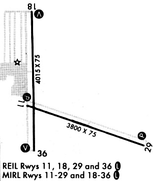
| Runways: | 11/29 18/36 |
| Longest Runway: | 18/36 is 5501 ft (1677 m) long |
| Runways with an Instrument Approach: |
KLXT Airport Runway Details
| Runway 11/29 | 4000 ft x 75 ft (1219 m x 23 m) | |
| Runway Length Source: | 3RD PARTY SURVEY as of 01/25/2022 | |
| Surface: | Concrete - Good condition - No special surface treatment | |
| Runway Edge Lights: | Medium Intensity | |
Runway Weight Bearing Capacity (in thousands of pounds) |
||
| Single Wheel Landing Gear: | 30.0 | |
| Dual Wheel Landing Gear: | 30.0 | |
Runway 11 |
Runway 29 |
|
Elevation: |
991.9 | 1001.6 |
Latitude: |
38-57-37.3926N | 38-57-21.6939N |
Longitude: |
094-22-31.7594W | 094-21-45.2848W |
|
Runway True Alignment: |
113 | 293 |
Glide Path Angle: |
3.0 degrees | 3.0 degrees |
Traffic Pattern: |
Right | |
Runway Markings Type: |
Nonprecision Instrument | Nonprecision Instrument |
Runway Markings Condition: |
Good | Good |
Visual Glide Slope Indicators: |
4-Light PAPI On Left Side Of Runway | 4-Light PAPI On Right Side Of Runway |
REIL: |
Yes | Yes |
Threshold Crossing Height: |
45 | 40 |
| Runway 18/36 | 5501 ft x 100 ft (1677 m x 30 m) | |
| Runway Length Source: | 3RD PARTY SURVEY as of 01/25/2022 | |
| Surface: | Concrete - Good condition - Saw-cut or plastic grooved | |
| Runway Pavement Class: | 22 /R/C/W/T | |
| Runway Edge Lights: | Medium Intensity | |
Runway Weight Bearing Capacity (in thousands of pounds) |
||
| Single Wheel Landing Gear: | 40.0 | |
| Dual Wheel Landing Gear: | 60.0 | |
Runway 18 |
Runway 36 |
|
Elevation: |
995.0 | 986.0 |
Latitude: |
38-58-02.2133N | 38-57-07.9411N |
Longitude: |
094-22-24.2518W | 094-22-28.3688W |
|
Runway True Alignment: |
183 | 003 |
Glide Path Angle: |
3.0 degrees | 3.0 degrees |
Traffic Pattern: |
Right | |
Runway Markings Type: |
Nonprecision Instrument | Nonprecision Instrument |
Runway Markings Condition: |
Good | Good |
Visual Glide Slope Indicators: |
4-Light PAPI On Left Side Of Runway | 4-Light PAPI On Left Side Of Runway |
REIL: |
Yes | Yes |
Threshold Crossing Height: |
44 | 45 |
Services
Airframe Repair: |
None |
Powerplant Repair: |
None |
Bottled Oxygen: |
None |
Bulk Oxygen: |
None |
Fuel Available: |
100LL, Jet A |
Landing Fees: |
No |
Parking: |
Hangars and tiedowns available |
Maps & Diagrams
KLXT Sectional
Flight Planning
at skyvector.com
at skyvector.com