Location
Latitude: |
27-11-43.1450N (27.195318) |
Longitude: |
081-50-17.6190W (-81.838228) |
Elevation: |
63.0 feet MSL (19 m MSL) |
Magnetic Variation: |
6.4 W (as of May 2024 from WMM2020 model) |
Time Zone: |
UTC -5.0 (Standard Time) UTC -4.0 (Daylight Savings Time) |
From City: |
01 N.M. SE of Arcadia, Florida |
Found On: |
Miami Chart |
FAA Region: |
ASO |
Contacts
Manager: |
Publicly owned: |
| SHELLEY PEACOCK 1067 SE AC POLK AVENUE ARCADIA, FL 34266 863-993-5670 |
CITY OF ARCADIA P.O. BOX 351 ARCADIA, FL 33821 863-494-4114 |
Operations
Airport Status: |
Operational |
Facility Use: |
Public |
Type: |
Airport |
Activation Date: |
07/1940 |
Control tower: |
No |
Attendance (Months/Days/Hours): |
Months/Days/Hours ALL/ALL/0800-1700 |
Boundary ARTCC: |
ZMA (Miami) |
Responsible ARTCC: |
ZMA (Miami) |
Lighting Schedule: |
SEE RMK |
Segmented Circle Indicator: |
No |
Traffic Pattern Altitude (MSL): |
1063 feet (324 m) |
NOTAMs Facility: |
PIE |
NOTAM-D Service: |
Yes |
International Airport of Entry: |
No |
Customs Landing Rights: |
No |
Military Landing Rights: |
No |
Civil/Military Joint Use: |
No |
Based Aircraft
| Single Engine: | 22 |
| Multi Engine: | 3 |
| GA Helicopters: | 2 |
| Ultralights: | 1 |
Annual Operations (as of 10/08/2018)
| Total Operations: | 19370 | |
| Air Taxi: | 30 | 0.2% |
| GA Local: | 12500 | 64.5% |
| GA Itinerant: | 6800 | 35.1% |
| Military Aircraft: | 40 | 0.2% |
Communications
| CTAF: | 123.000 |
| Unicom: | 123.000 |
- APCH/DEP SVC PRVDD BY MIAMI ARTCC (ZMA) ON FREQS 134.55/257.7 (AVON PARK RCAG).
Fixed Based Operators (FBOs) & Fuel
(Click on a business for detail)
Please help us keep this information up to date. This is a FREE SERVICE just like everything else on Airport Guide! If you see that a business needs to be added, modified, or deleted please fill out our Update Form.
To add, modify, or delete a business click here.
Please help us keep this information up to date. This is a FREE SERVICE just like everything else on Airport Guide! If you see that a business needs to be added, modified, or deleted please fill out our Update Form.
Area Code: 863 |
| Business Name | Frequency | Phone | Fuel Grade |
|---|---|---|---|
| Air-Cadia, Inc.
Update FBO info |
Unicom 123.0 | 494-7844 | 100LL, Jet A |
| Wine Ridge Aviation
Update FBO info |
800-287-9175 |
Flight Service Stations
| Primary | Alternate | |
| FSS on Field: | N | |
| FSS Name (ID): | Saint Petersburg(PIE) | |
| Frequency: | ||
| Toll Free Phone: | 1-800-WX-BRIEF |
Instrument Procedures / Charts
FAA Terminal Procedures valid from 0901Z 03/21/24 to 0901Z 04/18/24.
There are various types of charts available for an airport. They are listed in the Page Type column. Here is a legend for those types:
APD - Airport Diagram
DP - Departure Procedure Charts
HOT - Hot Spots
IAP - Instrument Approach Procedure Charts
MIN - Minimums
STAR - Standard Terminal Arrival Charts
| Page Type | Page Name | Volume | Action Since Last Cycle |
|---|---|---|---|
| IAP | RNAV (GPS)-A | SE-3 | |
| IAP | RNAV (GPS)-B | SE-3 | |
| MIN | TAKEOFF MINIMUMS | SE-3 |
Terminal Procedures are only available for airports in several countries with more being added all the time. If you are looking for a specific country's charts, please send an email to support(at)airportguide.com stating the country name. This will be used to prioritize the implementation.
Navigation Aids (Navaids) near X06
| Dist (NM) | ID | Morse Code | Name | Type | Freq | True Hdg | Mag Hdg |
|---|---|---|---|---|---|---|---|
| 18.6 | PGD | . _ _ . _ _ . _ . . | Punta Gorda | VOR | 110.20 | 206 | 212 |
| 32.5 | LBV | . _ . . _ . . . . . . _ | La Belle | VORTAC | 110.40 | 132 | 139 |
| 32.6 | VNC | . . . _ _ . _ . _ . | Venice | NDB | 206 | 255 | 261 |
| 40.1 | RSW | . _ . . . . . _ _ | Lee County | VORTAC | 114.15 | 175 | 181 |
| 40.7 | SRQ | . . . . _ . _ _ . _ | Sarasota | VOR-DME | 117.00 | 288 | 294 |
| 41.2 | FM | . . _ . _ _ | Caloo | NDB | 341 | 188 | 194 |
| 48.4 | LAL | . _ . . . _ . _ . . | Lakeland | VORTAC | 116.00 | 348 | 354 |
| 53.7 | MCF | _ _ _ . _ . . . _ . | Macdill | TACAN | 111.00 | 318 | 324 |
| 54.9 | AM | . _ _ _ | Picny | NDB | 388 | 316 | 322 |
| 59.5 | TPA | _ . _ _ . . _ | Tampa Intl | VOT | 111.00 | 321 | 327 |
| 62.1 | PIE | . _ _ . . . . | St Petersburg | VORTAC | 116.40 | 313 | 319 |
| 62.6 | CYY | _ . _ . _ . _ _ _ . _ _ | Cypress | VOR-DME | 108.60 | 177 | 183 |
| 64.2 | RHZ | . _ . . . . . _ _ . . | Zephyrhills | NDB | 253 | 344 | 350 |
| 64.7 | TP | _ . _ _ . | Cosme | NDB | 368 | 325 | 331 |
| 66.1 | PHK | . _ _ . . . . . _ . _ | Pahokee | VOR-DME | 115.40 | 111 | 118 |
| 66.5 | PI | . _ _ . . . | Capok | NDB | 360 | 316 | 322 |
| 77.4 | TRV | _ . _ . . . . _ | Treasure | VORTAC | 117.30 | 67 | 74 |
| 80.0 | FPR | . . _ . . _ _ . . _ . | Fort Pierce | NDB | 275 | 77 | 84 |
| 81.2 | SQT | . . . _ _ . _ _ | Satellite | NDB | 257 | 47 | 54 |
| 81.6 | OR | _ _ _ . _ . | Herny | NDB | 221 | 15 | 22 |
Nearby Airports with Fuel
Notices to Airmen (NOTAMS)
Remarks
| A110-2 | FOR CD CTC MIAMI ARTCC AT 305-716-1731. |
| A16 | 863-494-7844 |
| A42-14 | THR OUTLINED BY WHITE CONES. |
| A42-32 | THR OUTLINED BY WHITE CONES. |
| A51-14 | MKD WITH 3 WHITE CONES. |
| A51-32 | MKD WITH 3 WHITE CONES. |
| A57-14 | APCH RATIO 21:1 TO DSPLCD THR. |
| A57-32 | RWY 32 APCH RATIO 23:1 TO DTHR. |
| A81-APT | ACTVT MIRL RWY 06/24, PAPI RWY 06 - CTAF. |
| E111 | EXISTED PRIOR TO 1959. |
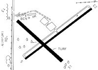
Runways
Runway Summary
| Runways: | 06/24 14/32 |
| Longest Runway: | 06/24 is 3700 ft (1128 m) long |
| Runways with an Instrument Approach: |
X06 Airport Runway Details
| Runway 06/24 | 3700 ft x 75 ft (1128 m x 23 m) | |
| Surface: | Asphalt - Excellent condition - No special surface treatment | |
| Runway Pavement Class: | 6 /F/B/Y/T | |
| Runway Edge Lights: | Medium Intensity | |
Runway 06 |
Runway 24 |
|
Elevation: |
59.7 | 63.0 |
Latitude: |
27-11-33.0152N | 27-11-55.3668N |
Longitude: |
081-50-30.2554W | 081-49-57.7884W |
|
Runway True Alignment: |
052 | 232 |
Glide Path Angle: |
3.0 degrees | 0.0 degrees |
Runway Markings Type: |
Nonprecision Instrument | Nonprecision Instrument |
Runway Markings Condition: |
Good | Good |
Object at End: |
ROAD | TREES |
Object Height: |
15 | 59 |
Distance from End: |
585 | 1455 |
Object Centerline Offset: |
125 ft. right of centerline | 135 ft. right of centerline |
Visual Glide Slope Indicators: |
2-Light PAPI On Left Side Of Runway | |
Threshold Crossing Height: |
25 |
| Runway 14/32 | 2400 ft x 100 ft (732 m x 30 m) | |
| Surface: | Asphalt - Excellent condition - No special surface treatment | |
Runway 14 |
Runway 32 |
|
Elevation: |
61.7 | 58.0 |
Latitude: |
27-11-49.6874N | 27-11-33.3754N |
Longitude: |
081-50-32.8283W | 081-50-13.4964W |
|
Runway True Alignment: |
133 | 313 |
Glide Path Angle: |
0.0 degrees | 0.0 degrees |
Traffic Pattern: |
Left | Left |
Runway Markings Type: |
Nonstandard (other than numbers only) | Nonstandard (other than numbers only) |
Runway Markings Condition: |
Fair | Fair |
Object at End: |
TREE | TREES |
Object Height: |
51 | 54 |
Distance from End: |
355 | 535 |
Object Centerline Offset: |
125 ft. right of centerline | 135 ft. right of centerline |
Threshold Elevation: |
60.8 | 59.8 |
Displaced Threshold: |
775 | 743 |
Threshold Latitude: |
27-11-44.4201N | 27-11-38.4234N |
Threshold Longitude: |
081-50-26.5856W | 081-50-19.4787W |
Services
Airframe Repair: |
None |
Powerplant Repair: |
None |
Bottled Oxygen: |
None |
Bulk Oxygen: |
None |
Fuel Available: |
100LL, Jet A, Jet A+ |
Landing Fees: |
No |
Parking: |
Hangars and tiedowns available |
Maps & Diagrams
X06 Sectional
Flight Planning
at skyvector.com
at skyvector.com