Location
Latitude: |
40-09-52.9000N (40.164694) |
Longitude: |
084-18-30.3000W (-84.308417) |
Elevation: |
993.1 feet MSL (303 m MSL) |
Magnetic Variation: |
6.3 W (as of April 2024 from WMM2020 model) |
Time Zone: |
UTC -5.0 (Standard Time) UTC -4.0 (Daylight Savings Time) |
From City: |
03 N.M. NW of Piqua, Ohio |
Found On: |
Detroit Chart |
FAA Region: |
AGL |
Contacts
Manager: |
Publicly owned: |
| MARK RUNGE 1 PROPELLER PL PIQUA, OH 45356-2655 937-778-4207 |
CITY OF PIQUA CITY BUILDING, 201 W WATER ST PIQUA, OH 45356-2235 937-778-2051 |
Operations
Airport Status: |
Operational |
Facility Use: |
Public |
Type: |
Airport |
Activation Date: |
04/1945 |
Control tower: |
No |
Attendance (Months/Days/Hours): |
Months/Days/Hours ALL/MON-FRI/0800-1700 |
Boundary ARTCC: |
ZID (Indianapolis) |
Responsible ARTCC: |
ZID (Indianapolis) |
Lighting Schedule: |
SEE RMK |
Segmented Circle Indicator: |
No |
Traffic Pattern Altitude (MSL): |
1993 feet (607 m) |
NOTAMs Facility: |
DAY |
NOTAM-D Service: |
Yes |
International Airport of Entry: |
No |
Customs Landing Rights: |
No |
Military Landing Rights: |
No |
Civil/Military Joint Use: |
No |
Based Aircraft
| Single Engine: | 27 |
| Ultralights: | 1 |
Annual Operations (as of 09/30/2021)
| Total Operations: | 12000 | |
| Air Taxi: | 200 | 1.7% |
| GA Local: | 4800 | 40.0% |
| GA Itinerant: | 7000 | 58.3% |
Communications
| CTAF: | 123.000 |
| Unicom: | 123.000 |
| Approach: | COLUMBUS 118.425 118.425 118.425 118.425 118.425 118.425 |
| Departure: | COLUMBUS 118.425 118.425 118.425 118.425 118.425 118.425 |
Fixed Based Operators (FBOs) & Fuel
(Click on a business for detail)
Please help us keep this information up to date. This is a FREE SERVICE just like everything else on Airport Guide! If you see that a business needs to be added, modified, or deleted please fill out our Update Form.
To add, modify, or delete a business click here.
Please help us keep this information up to date. This is a FREE SERVICE just like everything else on Airport Guide! If you see that a business needs to be added, modified, or deleted please fill out our Update Form.
Area Code: 937 |
| Business Name | Frequency | Phone | Fuel Grade |
|---|---|---|---|
| Hartzell Propeller Service Center
Update FBO info |
778-4201 | 100LL, Jet A |
Flight Service Stations
| Primary | Alternate | |
| FSS on Field: | N | |
| FSS Name (ID): | Dayton(DAY) | |
| Frequency: | ||
| Toll Free Phone: | 1-800-WX-BRIEF |
Instrument Procedures / Charts
FAA Terminal Procedures valid from 0901Z 03/21/24 to 0901Z 04/18/24.
There are various types of charts available for an airport. They are listed in the Page Type column. Here is a legend for those types:
APD - Airport Diagram
DP - Departure Procedure Charts
HOT - Hot Spots
IAP - Instrument Approach Procedure Charts
MIN - Minimums
STAR - Standard Terminal Arrival Charts
| Page Type | Page Name | Volume | Action Since Last Cycle |
|---|---|---|---|
| IAP | RNAV (GPS) RWY 08 | EC-2 | |
| IAP | RNAV (GPS) RWY 26 | EC-2 | |
| IAP | VOR RWY 26 | EC-2 | |
| IAP | VOR-A | EC-2 | |
| MIN | TAKEOFF MINIMUMS | EC-2 |
Terminal Procedures are only available for airports in several countries with more being added all the time. If you are looking for a specific country's charts, please send an email to support(at)airportguide.com stating the country name. This will be used to prioritize the implementation.
Navigation Aids (Navaids) near I17
| Dist (NM) | ID | Morse Code | Name | Type | Freq | True Hdg | Mag Hdg |
|---|---|---|---|---|---|---|---|
| 9.8 | DQN | _ . . _ _ . _ _ . | Dayton | VOR-DME | 114.50 | 204 | 210 |
| 14.2 | ROD | . _ . _ _ _ _ . . | Rosewood | VORTAC | 117.50 | 58 | 64 |
| 16.6 | DAY | _ . . . _ _ . _ _ | Dayton J M Cox-Day | VOT | 111.00 | 164 | 170 |
| 19.1 | AT | . _ _ | Bruny | NDB | 315 | 183 | 189 |
| 22.4 | CQA | _ . _ . _ _ . _ . _ | Lakefield | NDB | 205 | 328 | 334 |
| 23.8 | FFO | . . _ . . . _ . _ _ _ | Patterson | TACAN | 109.20 | 150 | 156 |
| 29.0 | SGH | . . . _ _ . . . . . | Springfield | DME | 113.2 | 132 | 138 |
| 29.1 | XSF | _ . . _ . . . . . _ . | Springfield | TACAN | 133.80 | 132 | 138 |
| 29.9 | CCJ | _ . _ . _ . _ . . _ _ _ | Clark County | NDB | 341 | 125 | 132 |
| 34.2 | RUV | . _ . . . _ . . . _ | Rushsylvania | NDB | 326 | 58 | 65 |
| 34.6 | RID | . _ . . . _ . . | Richmond | DME | 110.6 | 224 | 230 |
| 35.2 | MW | _ _ . _ _ | Onida | NDB | 223 | 181 | 187 |
| 36.1 | AOH | . _ _ _ _ . . . . | Allen County | VOR | 108.40 | 25 | 32 |
| 40.5 | HKF | . . . . _ . _ . . _ . | Hook Field | NDB | 239 | 189 | 195 |
| 44.1 | VFU | . . . _ . . _ . . . _ | Stanley | NDB | 411 | 341 | 347 |
| 44.4 | SQ | . . . _ _ . _ | Pnthr | NDB | 227 | 238 | 244 |
| 45.0 | OXD | _ _ _ _ . . _ _ . . | Oxford | NDB | 282 | 209 | 215 |
| 46.4 | JN | . _ _ _ _ . | Balll | NDB | 365 | 271 | 277 |
| 48.1 | IL | . . . _ . . | Airbo | NDB | 407 | 146 | 153 |
| 49.0 | HAO | . . . . . _ _ _ _ | Hamilton | NDB | 260 | 194 | 200 |
Nearby Airports with Fuel
Notices to Airmen (NOTAMS)
Remarks
| A110-1 | AEROBATIC BOX LCTD WI 1 NMR OF ARPT, BLW 4500 FT MSL, SR-SS. |
| A110-2 | ARPT CONDS UNMON MON-FRI 1600-0800, SAT-SUN, & HOLS. |
| A110-3 | FOR CD CTC COLUMBUS APCH AT 614-338-8537. |
| A17 | UNATNDD MAJOR HOLS. |
| A43-08 | PAPI UNUSBL BYD 6 DEGS RIGHT OF CNTRLN. |
| A58-08 | 10 FT MANURE STOCKPILE, 100-160 FT DIST, 225 FT R. |
| A58-26 | 2-6 FT CROPS, 0-200 FT DIST, 160 FT L TO 230 FT R. |
| A70-FUEL-10 | 0LL FUEL AVBL H24 VIA CREDIT CARD. |
| A71 | PROP RPRS. |
| A81-APT | ACTVT REIL RWY 08 & 26; MIRL RWY 08/26 - CTAF. PAPI RWY 08 & 26 OPR CONSLY. |
Runways
Runway Summary
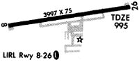
| Runways: | 08/26 |
| Longest Runway: | 08/26 is 3998 ft (1219 m) long |
| Runways with an Instrument Approach: |
I17 Airport Runway Details
| Runway 08/26 | 3998 ft x 75 ft (1219 m x 23 m) | |
| Runway Length Source: | 3RD PARTY SURVEY as of 06/27/2012 | |
| Surface: | Asphalt - Fair condition - No special surface treatment | |
| Runway Edge Lights: | Medium Intensity | |
Runway Weight Bearing Capacity (in thousands of pounds) |
||
| Single Wheel Landing Gear: | 30.0 | |
| Dual Wheel Landing Gear: | 36.0 | |
Runway 08 |
Runway 26 |
|
Elevation: |
993.1 | 984.7 |
Latitude: |
40-09-47.9391N | 40-09-57.8156N |
Longitude: |
084-18-55.2722W | 084-18-05.4181W |
|
Runway True Alignment: |
076 | 256 |
Glide Path Angle: |
3.0 degrees | 3.0 degrees |
Traffic Pattern: |
Left | Left |
Runway Markings Type: |
Nonprecision Instrument | Nonprecision Instrument |
Runway Markings Condition: |
Good | Good |
Object at End: |
TREE | |
Object Height: |
30 | |
Distance from End: |
643 | |
Object Centerline Offset: |
240 ft. right of centerline | |
Visual Glide Slope Indicators: |
2-Light PAPI On Left Side Of Runway | 2-Light PAPI On Left Side Of Runway |
REIL: |
Yes | Yes |
Touchdown Lights: |
No | No |
Centerline Lights: |
No | No |
Threshold Crossing Height: |
36 | 37 |
Services
Airframe Repair: |
Major |
Powerplant Repair: |
Major |
Bottled Oxygen: |
None |
Bulk Oxygen: |
None |
Fuel Available: |
100LL, Jet A-1, Jet A-1+ |
Landing Fees: |
No |
Parking: |
Hangars and tiedowns available |
Maps & Diagrams
I17 Sectional
Flight Planning
at skyvector.com
at skyvector.com