Location
Latitude: |
26-13-37.6000N (26.227111) |
Longitude: |
097-39-18.5000W (-97.655139) |
Elevation: |
36.3 feet MSL (11 m MSL) |
Magnetic Variation: |
3.2 E (as of April 2024 from WMM2020 model) |
Time Zone: |
UTC -6.0 (Standard Time) UTC -5.0 (Daylight Savings Time) |
From City: |
03 N.M. NE of Harlingen, Texas |
Found On: |
Brownsville Chart |
FAA Region: |
ASW |
Contacts
Manager: |
Publicly owned: |
| MARV ESTERLY AIRPORT TERMINAL BUILDING,, 3002 HE, 3200 HERITAGE WAY HARLINGEN, TX 78550 956-430-8605 |
CITY OF HARLINGEN PO BOX 2207 HARLINGEN, TX 78550-2207 (956) 430-8605 |
Operations
Airport Status: |
Operational |
Facility Use: |
Public |
Type: |
Airport |
Activation Date: |
07/1943 |
Control tower: |
Yes |
Attendance (Months/Days/Hours): |
Months/Days/Hours ALL/ALL/0600-0000 |
Boundary ARTCC: |
ZHU (Houston) |
Responsible ARTCC: |
ZHU (Houston) |
Lighting Schedule: |
SEE RMK |
Segmented Circle Indicator: |
Yes |
Traffic Pattern Altitude (MSL): |
1036 feet (316 m) |
NOTAMs Facility: |
HRL |
NOTAM-D Service: |
Yes |
International Airport of Entry: |
No |
Customs Landing Rights: |
No |
Military Landing Rights: |
Yes |
Civil/Military Joint Use: |
No |
Aircraft Rescue and Firefighting: |
Class I ARFF Index: B Air Carrier Service: Scheduled Certification Date: 05/1973 |
Based Aircraft
| Single Engine: | 35 |
| Multi Engine: | 12 |
| Jet Engine: | 9 |
Annual Operations (as of 12/31/2022)
| Total Operations: | 57602 | |
| Commercial: | 10864 | 18.9% |
| Air Taxi: | 3064 | 5.3% |
| GA Local: | 3226 | 5.6% |
| GA Itinerant: | 7117 | 12.4% |
| Military Aircraft: | 33331 | 57.9% |
Communications
| CTAF: | 119.300 |
| Unicom: | 122.950 |
| Tower: | HARLINGEN 119.3 317.6 Hrs: 0600-0000 |
| Ground: | 121.7 |
| Approach: | VALLEY 120.7 120.7 120.7 120.7 |
| Departure: | VALLEY 120.7 120.7 120.7 120.7 |
| ATIS: | 124.85 Hrs: 24 |
| ASOS: | 124.85 (956-428-7297) |
Fixed Based Operators (FBOs) & Fuel
(Click on a business for detail)
Please help us keep this information up to date. This is a FREE SERVICE just like everything else on Airport Guide! If you see that a business needs to be added, modified, or deleted please fill out our Update Form.
To add, modify, or delete a business click here.
Please help us keep this information up to date. This is a FREE SERVICE just like everything else on Airport Guide! If you see that a business needs to be added, modified, or deleted please fill out our Update Form.
Area Code: 956 |
| Business Name | Frequency | Phone | Fuel Grade |
|---|---|---|---|
| B/S Aviation
Update FBO info |
801-1878, 423-0380 | ||
| Gulf Aviation
Update FBO info |
Unicom 122.95 | 423-7317 | 100LL, Jet A |
| Gulf Avionics
Update FBO info |
Unicom 122.95 | 423-5770 |
Flight Service Stations
| Primary | Alternate | |
| FSS on Field: | N | |
| FSS Name (ID): | San Angelo(SJT) | |
| Frequency: | ||
| Toll Free Phone: | 1-800-WX-BRIEF |
Instrument Procedures / Charts
FAA Terminal Procedures valid from 0901Z 03/21/24 to 0901Z 04/18/24.
There are various types of charts available for an airport. They are listed in the Page Type column. Here is a legend for those types:
APD - Airport Diagram
DP - Departure Procedure Charts
HOT - Hot Spots
IAP - Instrument Approach Procedure Charts
MIN - Minimums
STAR - Standard Terminal Arrival Charts
| Page Type | Page Name | Volume | Action Since Last Cycle |
|---|---|---|---|
| APD | AIRPORT DIAGRAM | SC-3 | |
| HOT | HOT SPOT | SC-3 | |
| IAP | ILS OR LOC RWY 17R | SC-3 | |
| IAP | LOC/DME BC RWY 35L | SC-3 | |
| IAP | RNAV (GPS) RWY 17L | SC-3 | |
| IAP | RNAV (GPS) RWY 35R | SC-3 | |
| IAP | RNAV (GPS) Y RWY 13 | SC-3 | |
| IAP | RNAV (GPS) Y RWY 17R | SC-3 | |
| IAP | RNAV (GPS) Y RWY 31 | SC-3 | |
| IAP | RNAV (GPS) Y RWY 35L | SC-3 | |
| IAP | RNAV (RNP) Z RWY 13 | SC-3 | |
| IAP | RNAV (RNP) Z RWY 17R | SC-3 | |
| IAP | RNAV (RNP) Z RWY 31 | SC-3 | |
| IAP | RNAV (RNP) Z RWY 35L | SC-3 | |
| IAP | VOR RWY 17L | SC-3 | |
| IAP | VOR Z RWY 31 | SC-3 | |
| IAP | VOR/DME RWY 17R | SC-3 | |
| IAP | VOR/DME RWY 35L | SC-3 | |
| IAP | VOR/DME Y OR TACAN RWY 31 | SC-3 | |
| MIN | ALTERNATE MINIMUMS | SC-3 | |
| MIN | TAKEOFF MINIMUMS | SC-3 |
Terminal Procedures are only available for airports in several countries with more being added all the time. If you are looking for a specific country's charts, please send an email to support(at)airportguide.com stating the country name. This will be used to prioritize the implementation.
Navigation Aids (Navaids) near HRL
| Dist (NM) | ID | Morse Code | Name | Type | Freq | True Hdg | Mag Hdg |
|---|---|---|---|---|---|---|---|
| 0.2 | HRL | . . . . . _ . . _ . . | Harlingen | VOR-DME | 113.65 | 50 | 47 |
| 4.7 | HR | . . . . . _ . | Sebas | NDB | 338 | 358 | 355 |
| 16.6 | BR | _ . . . . _ . | Depoo | NDB | 393 | 151 | 148 |
| 23.6 | BRO | _ . . . . _ . _ _ _ | Brownsville | VORTAC | 116.30 | 140 | 137 |
| 28.3 | MAM | _ _ . _ _ _ | Matamoros | VOR-DME | 114.30 | 165 | 162 |
| 31.7 | MFE | _ _ . . _ . . | Mc Allen | VOR-DME | 117.20 | 264 | 261 |
| 33.7 | REX | . _ . . _ . . _ | Reynosa | VOR-DME | 112.40 | 247 | 244 |
| 35.3 | MF | _ _ . . _ . | Missi | NDB | 330 | 272 | 269 |
| 57.0 | SNE | . . . _ . . | Santa Elena | NDB | 260 | 301 | 298 |
| 63.9 | BKS | _ . . . _ . _ . . . | Brooks County | NDB | 353 | 337 | 334 |
| 76.7 | NQI | _ . _ _ . _ . . | Kingsville | TACAN | 117.80 | 354 | 351 |
| 85.9 | TKB | _ _ . _ _ . . . | Kleberg County | NDB | 347 | 344 | 341 |
| 89.3 | HBV | . . . . _ . . . . . . _ | Hebbronville | NDB | 266 | 319 | 316 |
| 89.6 | NGP | _ . _ _ . . _ _ . | Truax | TACAN | 114.00 | 12 | 9 |
| 92.8 | ALI | . _ . _ . . . . | Alice | VOR | 114.50 | 347 | 344 |
Nearby Airports with Fuel
| Dist (NM) | Name (Airport IDs) | True Hdg | Mag Hdg | Fuel Grade |
|---|---|---|---|---|
| 17.0 | Port Isabel-Cameron County Airport (KPIL PIL) |
102 | 99 | 100LL, Jet A |
| 17.4 | Mid Valley Airport (TXW) |
260 | 257 | 100LL, Jet A |
| 22.9 | Brownsville/South Padre Island International Airport (BRO KBRO BRO) |
147 | 144 | 100LL, Jet A |
| 31.6 | Mc Allen International Airport (MFE KMFE MFE) |
264 | 261 | 100LL, Jet A |
| 63.8 | Brooks County Airport (KBKS BKS) |
337 | 334 | 100LL, Jet A |
| 81.9 | Kleberg County Airport (KIKG IKG) |
345 | 342 | 100LL, Jet A |
| 83.1 | Bishop-Windham Airport (07R) |
356 | 353 | 100LL |
| 93.0 | Alice International Airport (ALI KALI ALI) |
347 | 344 | 100LL, Jet A |
| 93.1 | Corpus Christi International Airport (CRP KCRP CRP) |
4 | 1 | 100LL, Jet A |
| 96.4 | Zapata County Airport (KAPY APY) |
297 | 293 | 100LL, Jet A |
Notices to Airmen (NOTAMS)
Remarks
| A110-1 | MIGRATORY BIRDS ON & INVOF ARPT. |
| A110-2 | WHEN ATCT CLSD REQ ARFF THRU CORPUS APPROACH OR FLT SVC. |
| A110-3 | FOR CD WHEN ATCT IS CLSD CTC CRP APCH AT 361-299-4230. |
| A81-APT | DUSK-DAWN. WHEN ATCT CLSD ACTVT MALSR RWY 17R AND RWY 31- CTAF. |
| E80 | US CUSTOMS USER FEE ARPT. |
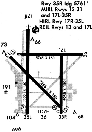
Runways
Runway Summary
| Runways: | 13/31 17L/35R 17R/35L |
| Longest Runway: | 17R/35L is 8301 ft (2530 m) long |
| Runways with an Instrument Approach: | 17R |
HRL Airport Runway Details
| Runway 13/31 | 7257 ft x 150 ft (2212 m x 46 m) | |
| Runway Length Source: | NGS as of 01/20/2001 | |
| Surface: | Asphalt - Good condition - Saw-cut or plastic grooved | |
| Runway Edge Lights: | High Intensity | |
Runway Weight Bearing Capacity (in thousands of pounds) |
||
| Single Wheel Landing Gear: | 160.0 | |
| Dual Wheel Landing Gear: | 200.0 | |
| Dual Tandem Wheel Landing Gear: | 350.0 | |
| Dual Dual Tandem Wheel Landing Gear: | 700.0 | |
Runway 13 |
Runway 31 |
|
Elevation: |
34.4 | 35.7 |
Latitude: |
26-13-59.4667N | 26-13-08.0929N |
Longitude: |
097-39-50.2832W | 097-38-54.5486W |
|
Runway True Alignment: |
136 | 316 |
Glide Path Angle: |
3.0 degrees | 3.0 degrees |
Traffic Pattern: |
Left | Left |
Runway Markings Type: |
Precision Instrument | Precision Instrument |
Runway Markings Condition: |
Good | Good |
Visual Glide Slope Indicators: |
4-Light PAPI On Left Side Of Runway | 4-Light PAPI On Left Side Of Runway |
Approach Light System: |
1,400 Foot Medium Intensity Approach Lighting System With Runway Alignment Indicator Lights | |
REIL: |
Yes | |
Threshold Crossing Height: |
59 | 55 |
Declared Distances |
||
Take Off Run Avbl. (TORA): |
7257 | 7257 |
Take Off Distance Avbl. (TODA): |
7257 | 7257 |
Actual Stop Dist. Avbl. (ASDA): |
7257 | 7257 |
Landing Dist. Avbl. (LDA): |
7257 | 7257 |
| Runway 17L/35R | 5949 ft x 150 ft (1813 m x 46 m) | |
| Runway Length Source: | NGS as of 01/20/2001 | |
| Surface: | Asphalt - Good condition - No special surface treatment | |
| Runway Edge Lights: | Medium Intensity | |
Runway Weight Bearing Capacity (in thousands of pounds) |
||
| Single Wheel Landing Gear: | 160.0 | |
| Dual Wheel Landing Gear: | 200.0 | |
| Dual Tandem Wheel Landing Gear: | 350.0 | |
Runway 17L |
Runway 35R |
|
Elevation: |
33.8 | 35.0 |
Latitude: |
26-14-02.2248N | 26-13-03.3085N |
Longitude: |
097-38-55.2920W | 097-38-56.0174W |
|
Runway True Alignment: |
181 | 001 |
Glide Path Angle: |
0.0 degrees | 0.0 degrees |
Traffic Pattern: |
Left | Right |
Runway Markings Type: |
Precision Instrument | Precision Instrument |
Runway Markings Condition: |
Good | Good |
REIL: |
Yes | |
Threshold Elevation: |
35.2 | |
Displaced Threshold: |
190 | |
Threshold Latitude: |
26-13-05.1884N | |
Threshold Longitude: |
097-38-55.9943W | |
Declared Distances |
||
Take Off Run Avbl. (TORA): |
5949 | 5949 |
Take Off Distance Avbl. (TODA): |
5949 | 5949 |
Actual Stop Dist. Avbl. (ASDA): |
5949 | 5949 |
Landing Dist. Avbl. (LDA): |
5949 | 5759 |
| Runway 17R/35L | 8301 ft x 150 ft (2530 m x 46 m) | |
| Runway Length Source: | NGS as of 01/20/2001 | |
| Surface: | Asphalt - Good condition - Saw-cut or plastic grooved | |
| Runway Edge Lights: | High Intensity | |
Runway Weight Bearing Capacity (in thousands of pounds) |
||
| Single Wheel Landing Gear: | 160.0 | |
| Dual Wheel Landing Gear: | 200.0 | |
| Dual Tandem Wheel Landing Gear: | 350.0 | |
| Dual Dual Tandem Wheel Landing Gear: | 700.0 | |
Runway 17R |
Runway 35L |
|
Elevation: |
34.0 | 35.7 |
Latitude: |
26-14-25.3797N | 26-13-03.1702N |
Longitude: |
097-39-30.8561W | 097-39-31.8746W |
|
Runway True Alignment: |
181 | 001 |
ILS Type: |
ILS/DME | |
Glide Path Angle: |
0.0 degrees | 3.0 degrees |
Traffic Pattern: |
Right | Left |
Runway Markings Type: |
Precision Instrument | Precision Instrument |
Runway Markings Condition: |
Good | Good |
Visual Glide Slope Indicators: |
4-Light PAPI On Right Side Of Runway | |
Approach Light System: |
1,400 Foot Medium Intensity Approach Lighting System With Runway Alignment Indicator Lights | |
Threshold Crossing Height: |
59 | |
Declared Distances |
||
Take Off Run Avbl. (TORA): |
8301 | 8301 |
Take Off Distance Avbl. (TODA): |
8301 | 8301 |
Actual Stop Dist. Avbl. (ASDA): |
8301 | 8301 |
Landing Dist. Avbl. (LDA): |
8301 | 8301 |
Services
Fuel Available: |
100LL, Jet A |
Parking: |
Hangars and tiedowns available |
Maps & Diagrams
HRL Sectional
Flight Planning
at skyvector.com
at skyvector.com