Location
Latitude: |
33-43-02.0000N (33.717222) |
Longitude: |
079-51-25.1000W (-79.856972) |
Elevation: |
66.5 feet MSL (20 m MSL) |
Magnetic Variation: |
8.4 W (as of April 2024 from WMM2020 model) |
Time Zone: |
UTC -5.0 (Standard Time) UTC -4.0 (Daylight Savings Time) |
From City: |
03 N.M. W of Kingstree, South Carolina |
Found On: |
Charlotte Chart |
FAA Region: |
ASO |
Contacts
Manager: |
Publicly owned: |
| JOHN HUDSON 85 AVIATION DRIVE KINGSTREE, SC 29556 (843) 372-2255 |
WILLIAMSBURG COUNTY PO BOX 1124 KINGSTREE, SC 29556 (843) 382-5800 |
Operations
Airport Status: |
Operational |
Facility Use: |
Public |
Type: |
Airport |
Activation Date: |
07/1970 |
Control tower: |
No |
Attendance (Months/Days/Hours): |
Months/Days/Hours Unattended |
Boundary ARTCC: |
ZJX (Jacksonville) |
Responsible ARTCC: |
ZJX (Jacksonville) |
Lighting Schedule: |
SEE RMK |
Segmented Circle Indicator: |
Yes |
Traffic Pattern Altitude (MSL): |
1066 feet (325 m) |
NOTAMs Facility: |
AND |
NOTAM-D Service: |
Yes |
Military Landing Rights: |
Yes |
Civil/Military Joint Use: |
No |
Based Aircraft
| Single Engine: | 15 |
| Multi Engine: | 1 |
| GA Helicopters: | 4 |
Annual Operations (as of 07/21/2022)
| Total Operations: | 6050 | |
| GA Local: | 5092 | 84.2% |
| GA Itinerant: | 908 | 15.0% |
| Military Aircraft: | 50 | 0.8% |
Communications
| CTAF: | 122.700 |
| Unicom: | 122.700 |
| Approach: | MYRTLE BEACH 127.4 127.4 JAX ARTCC |
| Departure: | MYRTLE BEACH 127.4 127.4 JAX ARTCC |
| AWOS-3: | 124.775 (843-382-3000) |
- APCH/DEP SVC PRVDD BY JACKSONVILLE ARTCC ON FREQS 134.375/317.55(CHARLESTON RCAG) WHEN MYRTLE BEACH APCH CTL CLSD.
Fixed Based Operators (FBOs) & Fuel
(Click on a business for detail)
Please help us keep this information up to date. This is a FREE SERVICE just like everything else on Airport Guide! If you see that a business needs to be added, modified, or deleted please fill out our Update Form.
To add, modify, or delete a business click here.
Please help us keep this information up to date. This is a FREE SERVICE just like everything else on Airport Guide! If you see that a business needs to be added, modified, or deleted please fill out our Update Form.
Area Code: 803 |
| Business Name | Frequency | Phone | Fuel Grade |
|---|
Flight Service Stations
| Primary | Alternate | |
| FSS on Field: | N | |
| FSS Name (ID): | Anderson(AND) | |
| Frequency: | ||
| Toll Free Phone: | 1-800-WX-BRIEF |
Instrument Procedures / Charts
FAA Terminal Procedures valid from 0901Z 03/21/24 to 0901Z 04/18/24.
There are various types of charts available for an airport. They are listed in the Page Type column. Here is a legend for those types:
APD - Airport Diagram
DP - Departure Procedure Charts
HOT - Hot Spots
IAP - Instrument Approach Procedure Charts
MIN - Minimums
STAR - Standard Terminal Arrival Charts
| Page Type | Page Name | Volume | Action Since Last Cycle |
|---|---|---|---|
| IAP | RNAV (GPS) RWY 14 | SE-2 | |
| IAP | RNAV (GPS) RWY 32 | SE-2 | |
| MIN | ALTERNATE MINIMUMS | SE-2 | |
| MIN | TAKEOFF MINIMUMS | SE-2 |
Terminal Procedures are only available for airports in several countries with more being added all the time. If you are looking for a specific country's charts, please send an email to support(at)airportguide.com stating the country name. This will be used to prioritize the implementation.
Navigation Aids (Navaids) near KCKI
| Dist (NM) | ID | Morse Code | Name | Type | Freq | True Hdg | Mag Hdg |
|---|---|---|---|---|---|---|---|
| 0.1 | CKI | _ . _ . _ . _ . . | Kingstree | NDB | 404 | 70 | 78 |
| 9.5 | CFY | _ . _ . . . _ . _ . _ _ | Evans | NDB | 420 | 28 | 36 |
| 16.6 | HEK | . . . . . _ . _ | Stuckey | NDB | 236 | 87 | 96 |
| 19.1 | MNI | _ _ _ . . . | Manning | NDB | 381 | 246 | 254 |
| 22.9 | PHH | . _ _ . . . . . . . . . | Andrews | NDB | 255 | 133 | 141 |
| 27.4 | FL | . . _ . . _ . . | Alcot | NDB | 335 | 0 | 8 |
| 30.0 | SMS | . . . _ _ . . . | Sumter | NDB | 252 | 303 | 311 |
| 32.5 | FLO | . . _ . . _ . . _ _ _ | Florence | VORTAC | 115.20 | 17 | 26 |
| 33.0 | VAN | . . . _ . _ _ . | Vance | VORTAC | 110.40 | 243 | 251 |
| 34.2 | SSC | . . . . . . _ . _ . | Shaw | TACAN | 110.10 | 297 | 305 |
| 35.9 | GGE | _ _ . _ _ . . | Georgetown | NDB | 242 | 131 | 140 |
| 36.9 | HYW | . . . . _ . _ _ . _ _ | Horry | NDB | 370 | 79 | 88 |
| 38.3 | MAO | _ _ . _ _ _ _ | Marion | NDB | 388 | 42 | 51 |
| 43.4 | HVS | . . . . . . . _ . . . | Hartsville | NDB | 341 | 342 | 350 |
| 43.6 | UDG | . . _ _ . . _ _ . | Darlington | NDB | 245 | 358 | 366 |
| 44.6 | DYB | _ . . _ . _ _ _ . . . | Dorchester County | NDB | 365 | 208 | 216 |
| 46.1 | CH | _ . _ . . . . . | Ashly | NDB | 329 | 195 | 203 |
| 48.7 | MMT | _ _ _ _ _ | Mc Entire | VORTAC | 113.20 | 285 | 293 |
| 49.6 | CHS | _ . _ . . . . . . . . | Charleston | VOT | 111.00 | 190 | 198 |
| 50.2 | CHS | _ . _ . . . . . . . . | Charleston | VORTAC | 113.50 | 190 | 198 |
Nearby Airports with Fuel
Notices to Airmen (NOTAMS)
Remarks
| A110-1 | FOR CD CTC MYRTLE BEACH APCH AT 843-477-2727 OR 843-477-2704, WHEN APCH CLSD CTC JACKSONVILLE ARTCC AT 904-845-1592. |
| A58-14 | 6 FT HI CORN 188 FT FROM RWY 14 THLD. |
| A81-APT | ACTVT MIRL RY 14/32 AND PAPI RYS 14 & 32 - CTAF. |
Runways
Runway Summary
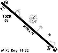
| Runways: | 14/32 |
| Longest Runway: | 14/32 is 5000 ft (1524 m) long |
| Runways with an Instrument Approach: |
KCKI Airport Runway Details
| Runway 14/32 | 5000 ft x 75 ft (1524 m x 23 m) | |
| Runway Length Source: | 3RD PARTY SURVEY as of 06/29/2014 | |
| Surface: | Asphalt - Good condition - No special surface treatment | |
| Runway Edge Lights: | Medium Intensity | |
Runway Weight Bearing Capacity (in thousands of pounds) |
||
| Single Wheel Landing Gear: | 30.0 | |
| Dual Wheel Landing Gear: | 45.0 | |
Runway 14 |
Runway 32 |
|
Elevation: |
65.5 | 64.8 |
Latitude: |
33-43-18.6334N | 33-42-45.3999N |
Longitude: |
079-51-47.0508W | 079-51-03.2083W |
|
Runway True Alignment: |
132 | 312 |
Glide Path Angle: |
3.0 degrees | 3.0 degrees |
Traffic Pattern: |
Left | Left |
Runway Markings Type: |
Nonprecision Instrument | Nonprecision Instrument |
Runway Markings Condition: |
Fair | Fair |
Object at End: |
TREE | |
Object Height: |
20 | |
Distance from End: |
649 | |
Object Centerline Offset: |
203 ft. left of centerline | |
Visual Glide Slope Indicators: |
2-Light PAPI On Left Side Of Runway | 2-Light PAPI On Left Side Of Runway |
REIL: |
No | No |
Touchdown Lights: |
No | No |
Centerline Lights: |
No | No |
Threshold Crossing Height: |
43 | 45 |
Services
Airframe Repair: |
None |
Powerplant Repair: |
None |
Bottled Oxygen: |
None |
Bulk Oxygen: |
None |
Fuel Available: |
100LL, Jet A |
Landing Fees: |
No |
Parking: |
Hangars and tiedowns available |
Maps & Diagrams
KCKI Sectional
Flight Planning
at skyvector.com
at skyvector.com