Location
Latitude: |
41-31-03.8690N (41.517741) |
Longitude: |
088-10-31.4300W (-88.175397) |
Elevation: |
582.3 feet MSL (177 m MSL) |
Magnetic Variation: |
3.7 W (as of April 2024 from WMM2020 model) |
Time Zone: |
UTC -6.0 (Standard Time) UTC -5.0 (Daylight Savings Time) |
From City: |
04 N.M. W of Joliet, Illinois |
Found On: |
Chicago Chart |
FAA Region: |
AGL |
Contacts
Manager: |
Publicly owned: |
| JENNIFER MCFARLAND 4000 W JEFFERSON JOLIET, IL 60431 815-741-7267 |
JOLIET PARK DISTRICT 4000 W JEFFERSON JOLIET, IL 60431 815-741-7275 |
Operations
Airport Status: |
Operational |
Facility Use: |
Public |
Type: |
Airport |
Activation Date: |
04/1940 |
Control tower: |
No |
Attendance (Months/Days/Hours): |
Months/Days/Hours ALL/SUN/UNATND |
Boundary ARTCC: |
ZAU (Chicago) |
Responsible ARTCC: |
ZAU (Chicago) |
Lighting Schedule: |
SEE RMK |
Segmented Circle Indicator: |
No |
Traffic Pattern Altitude (MSL): |
1582 feet (482 m) |
NOTAMs Facility: |
JOT |
NOTAM-D Service: |
Yes |
International Airport of Entry: |
No |
Customs Landing Rights: |
No |
Military Landing Rights: |
Yes |
Civil/Military Joint Use: |
No |
Based Aircraft
| Single Engine: | 63 |
| Multi Engine: | 2 |
Annual Operations (as of 07/31/2022)
| Total Operations: | 25000 | |
| Air Taxi: | 2000 | 8.0% |
| GA Local: | 11000 | 44.0% |
| GA Itinerant: | 11300 | 45.2% |
| Military Aircraft: | 700 | 2.8% |
Communications
| CTAF: | 122.700 |
| Unicom: | 122.700 |
| Approach: | CHICAGO 119.35 119.35 |
| Departure: | CHICAGO 119.35 119.35 |
| AWOS-3: | 119.975 (815-730-9560) |
Fixed Based Operators (FBOs) & Fuel
(Click on a business for detail)
Please help us keep this information up to date. This is a FREE SERVICE just like everything else on Airport Guide! If you see that a business needs to be added, modified, or deleted please fill out our Update Form.
To add, modify, or delete a business click here.
Please help us keep this information up to date. This is a FREE SERVICE just like everything else on Airport Guide! If you see that a business needs to be added, modified, or deleted please fill out our Update Form.
Area Code: 815 |
| Business Name | Frequency | Phone | Fuel Grade |
|---|---|---|---|
| JF Aviation, Inc.
Update FBO info |
744-7528 | ||
| Joliet Regional Airport
Update FBO info |
Unicom 122.7 | 741-7267 | 80, 100LL, Jet A |
| South Suburban Aviation
Update FBO info |
725-7305 |
Flight Service Stations
| Primary | Alternate | |
| FSS on Field: | N | |
| FSS Name (ID): | Kankakee(IKK) | |
| Frequency: | ||
| Toll Free Phone: | 1-800-WX-BRIEF |
Instrument Procedures / Charts
| Page Type | Page Name | Volume | Action Since Last Cycle |
|---|
Terminal Procedures are only available for airports in several countries with more being added all the time. If you are looking for a specific country's charts, please send an email to support(at)airportguide.com stating the country name. This will be used to prioritize the implementation.
Navigation Aids (Navaids) near JOT
| Dist (NM) | ID | Morse Code | Name | Type | Freq | True Hdg | Mag Hdg |
|---|---|---|---|---|---|---|---|
| 6.6 | JOT | . _ _ _ _ _ _ _ | Joliet | VOR-DME | 112.30 | 285 | 289 |
| 19.4 | HK | . . . . _ . _ | Ermin | NDB | 332 | 51 | 55 |
| 22.8 | EON | . _ _ _ _ . | Peotone | VORTAC | 113.20 | 130 | 134 |
| 23.7 | DPA | _ . . . _ _ . . _ | Dupage | VOR-DME | 108.40 | 340 | 344 |
| 24.9 | MDW | _ _ _ . . . _ _ | Chicago Midway | VOT | 111.00 | 49 | 53 |
| 25.6 | MX | _ _ _ . . _ | Kedzi | NDB | 248 | 58 | 62 |
| 27.1 | CGT | _ . _ . _ _ . _ | Chicago Heights | VORTAC | 114.20 | 90 | 94 |
| 27.8 | ME | _ _ . | Deana | NDB | 350 | 13 | 17 |
| 30.4 | IKK | . . _ . _ _ . _ | Kankakee | DME | 111.6 | 151 | 155 |
| 30.7 | ORD | _ _ _ . _ . _ . . | Chicago O'hare | VOR-DME | 113.90 | 23 | 27 |
| 31.1 | GCO | _ _ . _ . _ . _ _ _ | Chicago | DME | 108.25 | 23 | 27 |
| 31.9 | OIX | _ _ _ . . _ . . _ | Ottawa | NDB | 266 | 253 | 256 |
| 32.4 | IK | . . _ . _ | Lukow | NDB | 272 | 157 | 161 |
| 43.4 | OBK | _ _ _ _ . . . _ . _ | Northbrook | VOR-DME | 113.00 | 13 | 17 |
| 48.8 | PNT | . _ _ . _ . _ | Pontiac | VOR-DME | 109.60 | 211 | 214 |
| 54.6 | RF | . _ . . . _ . | Gilmy | NDB | 275 | 311 | 314 |
| 56.2 | RBS | . _ . _ . . . . . . | Roberts | VOR-DME | 116.80 | 179 | 183 |
| 58.5 | VP | . . . _ . _ _ . | Sedly | NDB | 212 | 93 | 97 |
| 59.2 | UG | . . _ _ _ . | Wauke | NDB | 379 | 16 | 20 |
| 62.4 | RFD | . _ . . . _ . _ . . | Rockford | DME | 110.8 | 313 | 316 |
Nearby Airports with Fuel
Notices to Airmen (NOTAMS)
Remarks
| A110-1 | FOR CD CTC CHICAGO APCH AT 847-289-0926. |
| A42-04 | RWY 04 /22 MKD WITH TIRES PAINTED WHITE; THLD MKD WITH WHITE GRAVEL. |
| A57-13 | APCH RATIO 16:1 TO DTHR. |
| A57-31 | APCH RATIO 13:1 TO DTHR. |
| A81-APT | MIRL RY 13/31 PRESET ON LOW INTST - TO ACTVT INCR INTST PAPI RY 13; MIRL RY 13/31 - CTAF. |
| E111 | EXISTED PRIOR TO 1959. |
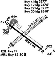
Runways
Runway Summary
| Runways: | 04/22 13/31 |
| Longest Runway: | 13/31 is 2821 ft (860 m) long |
| Runways with an Instrument Approach: |
JOT Airport Runway Details
| Runway 04/22 | 2552 ft x 150 ft (778 m x 46 m) | |
| Runway Length Source: | FAA OE/AAA as of 03/19/2012 | |
| Surface: | Turf - Good condition - No special surface treatment | |
Runway 04 |
Runway 22 |
|
Elevation: |
575.3 | 578.4 |
Latitude: |
41-30-56.0161N | 41-31-14.1023N |
Longitude: |
088-10-43.8672W | 088-10-20.4930W |
|
Runway True Alignment: |
044 | 224 |
Glide Path Angle: |
0.0 degrees | 0.0 degrees |
Traffic Pattern: |
Left | Left |
Object at End: |
TREE | |
Object Height: |
52 | |
Distance from End: |
673 | |
Object Centerline Offset: |
145 ft. right of centerline | |
REIL: |
No | No |
Touchdown Lights: |
No | No |
Centerline Lights: |
No | No |
| Runway 13/31 | 2821 ft x 100 ft (860 m x 30 m) | |
| Runway Length Source: | 3RD PARTY SURVEY as of 11/20/2014 | |
| Surface: | Turf - Good condition - No special surface treatment | |
| Runway Edge Lights: | Medium Intensity | |
Runway Weight Bearing Capacity (in thousands of pounds) |
||
| Single Wheel Landing Gear: | 8.0 | |
Runway 13 |
Runway 31 |
|
Elevation: |
580.5 | 577.4 |
Latitude: |
41-31-11.1111N | 41-30-54.4746N |
Longitude: |
088-10-45.6308W | 088-10-15.8742W |
|
Runway True Alignment: |
127 | 307 |
Glide Path Angle: |
3.5 degrees | 0.0 degrees |
Traffic Pattern: |
Left | Left |
Runway Markings Type: |
Nonprecision Instrument | Nonprecision Instrument |
Runway Markings Condition: |
Fair | Fair |
Object at End: |
TREE | TREE |
Object Height: |
44 | 58 |
Distance from End: |
605 | 690 |
Object Centerline Offset: |
145 ft. right of centerline | |
Visual Glide Slope Indicators: |
4-Light PAPI On Right Side Of Runway | |
REIL: |
No | No |
Touchdown Lights: |
No | No |
Centerline Lights: |
No | No |
Threshold Crossing Height: |
41 | |
Threshold Elevation: |
580.5 | 578.1 |
Displaced Threshold: |
100 | 80 |
Threshold Latitude: |
41-31-10.5156N | 41-30-54.9459N |
Threshold Longitude: |
088-10-44.5754W | 088-10-16.7182W |
Services
Airframe Repair: |
Major |
Powerplant Repair: |
Major |
Bottled Oxygen: |
Low Pressure |
Bulk Oxygen: |
Low Pressure |
Fuel Available: |
100LL, Jet A, UL94 |
Landing Fees: |
No |
Parking: |
Hangars and tiedowns available |
Maps & Diagrams
JOT Sectional
Flight Planning
at skyvector.com
at skyvector.com