Location
Latitude: |
58-40-35.3765N (58.676493) |
Longitude: |
156-38-55.2876W (-156.648691) |
Elevation: |
73.4 feet MSL (22 m MSL) |
Magnetic Variation: |
12.1 E (as of April 2024 from WMM2020 model) |
Time Zone: |
UTC -9.0 (Standard Time) UTC -8.0 (Daylight Savings Time) |
From City: |
00 N.M. SE of King Salmon, Alaska |
Found On: |
Kodiak Chart |
FAA Region: |
AAL |
Contacts
Manager: |
Publicly owned: |
| FLOYD WILSON PO BOX 65 KING SALMON, AK 99613 907-246-3325 |
ALASKA DOT&PF SOUTHCOAST REGION PO BOX 112500 JUNEAU, AK 99811-2500 907-465-4512 |
Operations
Airport Status: |
Operational |
Facility Use: |
Public |
Type: |
Airport |
Activation Date: |
08/1954 |
Control tower: |
Yes |
Attendance (Months/Days/Hours): |
Months/Days/Hours ALL/ALL/0700-1700 |
Boundary ARTCC: |
ZAN (Anchorage) |
Responsible ARTCC: |
ZAN (Anchorage) |
Lighting Schedule: |
SEE RMK |
Segmented Circle Indicator: |
Yes |
Traffic Pattern Altitude (MSL): |
1073 feet (327 m) |
NOTAMs Facility: |
AKN |
NOTAM-D Service: |
Yes |
International Airport of Entry: |
No |
Customs Landing Rights: |
No |
Military Landing Rights: |
Yes |
Civil/Military Joint Use: |
No |
Aircraft Rescue and Firefighting: |
Class I ARFF Index: B Air Carrier Service: Scheduled Certification Date: 03/2005 |
Based Aircraft
| Single Engine: | 33 |
| Multi Engine: | 3 |
| GA Helicopters: | 3 |
Annual Operations (as of 06/30/2021)
| Total Operations: | 25201 | |
| Commercial: | 1720 | 6.8% |
| Air Taxi: | 16434 | 65.2% |
| GA Local: | 1425 | 5.7% |
| GA Itinerant: | 4645 | 18.4% |
| Military Aircraft: | 977 | 3.9% |
Communications
| CTAF: | 121.900 |
| Unicom: | 122.950 |
| Tower: | KING SALMON 118.3 279.5 Hrs: 0800-2000 1 AUG-14 JUN. 0800-2200 15 JUN- 31 JUL. |
| Ground: | 121.9 |
| Approach: | ANCHORAGE ARTCC |
| Departure: | ANCHORAGE ARTCC |
| ATIS: | 128.8 Hrs: 24 |
| ASOS: | 128.8 (907-246-7506) |
| PTD: | 372.2 |
- APCH/DEP SVC PRVDD BY ANCHORAGE ARTCC ON FREQS 124.8/354.0 (KING SALMON RCAG).
- FREQS 118.3 UNAVBL WHEN ATCT CLSD.
Fixed Based Operators (FBOs) & Fuel
(Click on a business for detail)
Please help us keep this information up to date. This is a FREE SERVICE just like everything else on Airport Guide! If you see that a business needs to be added, modified, or deleted please fill out our Update Form.
To add, modify, or delete a business click here.
Please help us keep this information up to date. This is a FREE SERVICE just like everything else on Airport Guide! If you see that a business needs to be added, modified, or deleted please fill out our Update Form.
Area Code: 907 |
| Business Name | Frequency | Phone | Fuel Grade |
|---|---|---|---|
| Egli Air Haul, Inc.
Website Update FBO info |
Unicom 122.95 | 246-3554 | 100LL, Jet A |
Flight Service Stations
| Primary | Alternate | |
| FSS on Field: | N | |
| FSS Name (ID): | Kenai(ENA) | |
| Frequency: | ||
| Toll Free Phone: | 1-866-864-1737 |
Instrument Procedures / Charts
FAA Terminal Procedures valid from 0901Z 03/21/24 to 0901Z 04/18/24.
There are various types of charts available for an airport. They are listed in the Page Type column. Here is a legend for those types:
APD - Airport Diagram
DP - Departure Procedure Charts
HOT - Hot Spots
IAP - Instrument Approach Procedure Charts
MIN - Minimums
STAR - Standard Terminal Arrival Charts
| Page Type | Page Name | Volume | Action Since Last Cycle |
|---|---|---|---|
| APD | AIRPORT DIAGRAM | AK-1 | |
| IAP | HI-ILS Z OR LOC Z RWY 12 | AK-1 | |
| IAP | HI-VOR OR TACAN Z RWY 12 | AK-1 | |
| IAP | HI-VOR Z OR TACAN Z RWY 30 | AK-1 | |
| IAP | ILS Y OR LOC Y RWY 12 | AK-1 | |
| IAP | LOC BC RWY 30 | AK-1 | |
| IAP | RNAV (GPS) RWY 12 | AK-1 | |
| IAP | RNAV (GPS) RWY 30 | AK-1 | |
| IAP | VOR Y OR TACAN Y RWY 12 | AK-1 | |
| IAP | VOR Y OR TACAN Y RWY 30 | AK-1 | |
| MIN | ALTERNATE MINIMUMS | AK-1 | |
| MIN | TAKEOFF MINIMUMS | AK-1 |
Terminal Procedures are only available for airports in several countries with more being added all the time. If you are looking for a specific country's charts, please send an email to support(at)airportguide.com stating the country name. This will be used to prioritize the implementation.
Navigation Aids (Navaids) near AKN
| Dist (NM) | ID | Morse Code | Name | Type | Freq | True Hdg | Mag Hdg |
|---|---|---|---|---|---|---|---|
| 4.3 | AKN | . _ _ . _ _ . | King Salmon | VORTAC | 112.80 | 311 | 299 |
| 5.4 | AUB | . _ . . _ _ . . . | Chinook | NDB | 355 | 312 | 300 |
| 38.4 | HCP | . . . . _ . _ . . _ _ . | Kulik Lake | NDB | 334 | 57 | 45 |
| 62.1 | BTS | _ . . . _ . . . | Wood River | NDB | 429 | 289 | 277 |
| 62.1 | DLG | _ . . . _ . . _ _ . | Dillingham | VOR-DME | 116.40 | 288 | 276 |
| 83.6 | ILI | . . . _ . . . . | Iliamna | NDB-DME | 411 | 38 | 26 |
Nearby Airports with Fuel
| Dist (NM) | Name (Airport IDs) | True Hdg | Mag Hdg | Fuel Grade |
|---|---|---|---|---|
| 0.0 | King Salmon Airport (AKN PAKN AKN) |
0 | 348 | 100LL, Jet A |
| 61.7 | Dillingham Airport (DLG PADL DLG) |
291 | 280 | 100LL, Jet A |
| 70.8 | Aleknagik Seaplane Base (Z33) |
301 | 290 | 100LL, MOGAS |
| 70.9 | Aleknagik /New Airport (WKK 5A8) |
301 | 290 | 100LL, Jet A, Mogas |
| 83.8 | Iliamna Airport (ILI PAIL ILI) |
38 | 25 | 100LL, Jet A |
Notices to Airmen (NOTAMS)
Remarks
| A110-10 | FIGHTER ARR EXP RDCD SEPN; SIMILAR APCH CHARCS & DALGT 3000 FT; DISSIMILAR APCH CHARCS & NGT 6000 FT; AHD/BHND FRMN LNDG 6000 FT. |
| A110-11 | 600 FT SAFETY AREA AER 12. |
| A110-12 | RCR DURG 11TH AF FIGHTER FLYING WINDOW; COORD RCR WITH KING SALMON OPS 907-439-3001/907-439-6000. OPS RSTRD TO LOW APCH/FSL ONLY. |
| A110-14 | FLIGHT ORIG OUTSIDE AK REFER TO USAF FCG; CSTMS NOT AVBL. |
| A110-15 | SNOW/ICE REMOVAL & ARPT HAZ COND RPRTD DURG ATND HR. |
| A110-16 | USAF FAC CIV OPRD WITH LTD SUPPORT; CALL 24 HR PRIOR TO ARR FOR OPS HR; MIL CONFIRM FUEL RQMNTS 24-48 HR PRIOR. |
| A110-17 | MIL FIGHTER/EMERG DVRSN CTC WARRIOR/ELMENDORF SOF 395.15; NON FIGHTER/EMERG CTC KING SALMON OPS. 24 HR POINT MNTS CTAF DURG OPS HR. |
| A110-2 | FLOCKS OF LRG BIRDS INVOF DURG SEASON. |
| A110-20 | PVT JET PRKG SE SECTION OF E RAMP - AMGR FOR INFO. |
| A110-26 | GA APRON PAVEMENT CRUMBLING; PSBL FOD HAZ. JET ACFT BE ALERT DURG RUN UP TO AVOID JET WASH DMG. |
| A110-27 | WX CAMERA AVBL ON INTERNET AT HTTPS://WEATHERCAMS.FAA.GOV |
| A110-28 | TWY P CLSD. APRON SPOTS 4 - 7 N OF MIL HANGAR CLSD EXC PROP ACFT. |
| A110-29 | ARFF AVBL FOR PART 121 ACR INVOLVED IN ETOPS WITH 30 MIN NOTICE. |
| A110-3 | OFF PAVEMENT OPS BY ACFT & HEL NA AT ACR APRON. LNDG, TKOF OR PRKG FM DIRT OR GRASS NA. |
| A110-31 | NWS BLN LAUNCH FAC ON ARPT; SEE INSIDE BACK COVER FOR OPS DETAIL. |
| A110-32 | LOCKED WHEEL TURN NA ALL SFCS. |
| A110-33 | TSA REG ARPT; SEE 49 CFR 1542. ALL GATES & DOORS RMN SECURE ALL TIMES. TSNT OR UNFAMILIAR PILOTS - AMGR FOR INFO. |
| A110-34 | BUSINESS JET PRKG GTR THAN 1 HR 48 HR PPR. |
| A110-7 | CIV TSNT PRKG ON SE RAMP ONLY; OTR PRKG GTR THAN 48 HR RQRS PERMIT. |
| A26 | ARFF EQUIP STAFFED DURG ACR ACT ONLY. |
| A26 1 | CLSD TO ACR OPS WITH MORE THAN 30 PAX SEATS EXC PPR IN WRITING - AMGR PO BOX 65 KING SALMON AK 99613. |
| A30-18/36 | NOT INSPD FOR MIL OPS. ACR OPS WITH MORE THAN 30 PAX SEATS NA. 1 IN DIP ON CNTRLN 1850 FT FM AER 36 EXTDS TO 3 IN DIP 25 FT WIDE ON W EDGE. |
| A30-NW/SE | ALSO USED BY BOATS. |
| A47-12 | TOUCHDOWN RVR AVBL 0800-2000 1 AUG-14 JUN; 0800-2200 15 JUN- 31 JUL. |
| A70-FUEL-10 | 0LL 100LL & JET A AVBL AT SEAPLANE BASE FM TRUCK OR UNICOM 122.95. |
| A75 | MKD TSNT PRKG N END OF GA RAMP & E END OF CARGO RAMP. |
| A81-APT | WHEN ATCT CLSD ACTVT SSALR RWY 12; PAPI RWY 12 & 30; MIRL RWY 18/36; HIRL RWY 12/30 - CTAF. |
| E100 | CTAF 352.05. FREQ 121.9 SIMULCAST WITH 352.05. |
| E60-12 | BAK-12 1190 FT FM THR; RWY 12 BAK-12 REQ 30 MIN NOTICE 950 FT RUNOUT. |
| E60-30 | BAK-12 1340 FT FM THR; BAK-12 REQ 30 MIN NOTICE 1200 FT RUNOUT. |
Runways
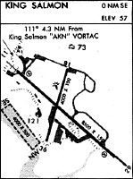
Runway Summary
| Runways: | 12/30 18/36 NW/SE |
| Longest Runway: | 12/30 is 8901 ft (2713 m) long |
| Runways with an Instrument Approach: | 12 |
AKN Airport Runway Details
| Runway 12/30 | 8901 ft x 150 ft (2713 m x 46 m) | |
| Runway Length Source: | AVN as of 12/08/2008 | |
| Surface: | Asphalt - Good condition - Saw-cut or plastic grooved | |
| Runway Pavement Class: | 67 /F/B/X/T | |
| Runway Edge Lights: | High Intensity | |
Runway Weight Bearing Capacity (in thousands of pounds) |
||
| Single Wheel Landing Gear: | 67.0 | |
| Dual Wheel Landing Gear: | 90.0 | |
| Dual Tandem Wheel Landing Gear: | 175.0 | |
| Dual Dual Tandem Wheel Landing Gear: | 335.0 | |
Runway 12 |
Runway 30 |
|
Elevation: |
59.9 | 73.4 |
Latitude: |
58-41-02.1840N | 58-40-03.6800N |
Longitude: |
156-39-53.0154W | 156-37-47.6300W |
|
Runway True Alignment: |
132 | 312 |
ILS Type: |
ILS/DME | |
Glide Path Angle: |
3.0 degrees | 3.0 degrees |
Traffic Pattern: |
Left | Left |
Runway Markings Type: |
Precision Instrument | Precision Instrument |
Runway Markings Condition: |
Poor | Poor |
Arresting Device: |
BAK-12 | BAK-12 |
Visual Glide Slope Indicators: |
4-Light PAPI On Left Side Of Runway | 4-Light PAPI On Left Side Of Runway |
Runway Visual Range (RVR): |
Touchdown | Rollout |
Approach Light System: |
Simplified Short Approach Lighting System With Runway Alignment Indicator Lights | |
REIL: |
No | |
Threshold Crossing Height: |
66 | 45 |
Declared Distances |
||
Take Off Run Avbl. (TORA): |
8901 | 8901 |
Take Off Distance Avbl. (TODA): |
8901 | 8901 |
Actual Stop Dist. Avbl. (ASDA): |
8501 | 8501 |
Landing Dist. Avbl. (LDA): |
8501 | 8501 |
| Runway 18/36 | 4017 ft x 100 ft (1224 m x 30 m) | |
| Runway Length Source: | ADO as of 04/15/2014 | |
| Surface: | Asphalt - Good condition - Saw-cut or plastic grooved | |
| Runway Pavement Class: | 66 /F/B/X/T | |
| Runway Edge Lights: | Medium Intensity | |
Runway Weight Bearing Capacity (in thousands of pounds) |
||
| Single Wheel Landing Gear: | 30.0 | |
| Dual Wheel Landing Gear: | 50.0 | |
Runway 18 |
Runway 36 |
|
Elevation: |
66.1 | 59.9 |
Latitude: |
58-40-59.7835N | 58-40-21.7997N |
Longitude: |
156-38-55.6139W | 156-39-16.9583W |
|
Runway True Alignment: |
196 | 016 |
Glide Path Angle: |
0.0 degrees | 0.0 degrees |
Traffic Pattern: |
Left | Left |
Runway Markings Type: |
Nonprecision Instrument | Nonprecision Instrument |
Runway Markings Condition: |
Good | Good |
Object at End: |
TREES | |
Object Height: |
40 | |
Distance from End: |
1000 |
| Runway NW/SE | 4000 ft x 500 ft (1219 m x 152 m) | |
| Surface: | Asphalt - Good condition - No special surface treatment | |
Runway NW |
Runway SE |
|
Glide Path Angle: |
0.0 degrees | 0.0 degrees |
Traffic Pattern: |
Left | Left |
Services
Fuel Available: |
100LL, Jet A |
Parking: |
Tiedowns available |
Maps & Diagrams
AKN Sectional
Flight Planning
at skyvector.com
at skyvector.com