Location
Latitude: |
44-52-01.8000N (44.867167) |
Longitude: |
108-47-36.3000W (-108.793417) |
Elevation: |
5095.7 feet MSL (1553 m MSL) |
Magnetic Variation: |
10.2 E (as of April 2024 from WMM2020 model) |
Time Zone: |
UTC -7.0 (Standard Time) UTC -6.0 (Daylight Savings Time) |
From City: |
07 N.M. N of Powell, Wyoming |
Found On: |
Billings Chart |
FAA Region: |
ANM |
Contacts
Manager: |
Publicly owned: |
| BEN HUBBARD 270 NORTH CLARK POWELL, WY 82435 307-754-5234 |
CITY OF POWELL 270 NORTH CLARK POWELL, WY 82435 307-754-6921 |
Operations
Airport Status: |
Operational |
Facility Use: |
Public |
Type: |
Airport |
Activation Date: |
11/1937 |
Control tower: |
No |
Attendance (Months/Days/Hours): |
Months/Days/Hours ALL/MON-FRI/0800-1700 |
Boundary ARTCC: |
ZLC (Salt Lake City) |
Responsible ARTCC: |
ZLC (Salt Lake City) |
Lighting Schedule: |
SEE RMK |
Segmented Circle Indicator: |
Yes |
Traffic Pattern Altitude (MSL): |
6096 feet (1858 m) |
NOTAMs Facility: |
CPR |
NOTAM-D Service: |
Yes |
International Airport of Entry: |
No |
Customs Landing Rights: |
No |
Military Landing Rights: |
Yes |
Civil/Military Joint Use: |
No |
Based Aircraft
| Single Engine: | 26 |
| Multi Engine: | 1 |
| Gliders: | 7 |
Annual Operations (as of 06/30/2022)
| Total Operations: | 4804 | |
| Air Taxi: | 300 | 6.2% |
| GA Local: | 3600 | 74.9% |
| GA Itinerant: | 900 | 18.7% |
| Military Aircraft: | 4 | 0.1% |
Communications
| CTAF: | 122.700 |
| Unicom: | 122.700 |
| AWOS-3: | 119.275 (307-754-7093) |
- COMMUNICATIONS PRVDD BY CASPER RADIO ON FREQ 122.3 (CODY RCO).
- APCH/DEP CTL SVC PRVDD BY SALT LAKE ARTCC (ZLC) ON 127.75/351.9 (LOVELL RCAG).
Fixed Based Operators (FBOs) & Fuel
(Click on a business for detail)
Please help us keep this information up to date. This is a FREE SERVICE just like everything else on Airport Guide! If you see that a business needs to be added, modified, or deleted please fill out our Update Form.
To add, modify, or delete a business click here.
Please help us keep this information up to date. This is a FREE SERVICE just like everything else on Airport Guide! If you see that a business needs to be added, modified, or deleted please fill out our Update Form.
Area Code: 307 |
| Business Name | Frequency | Phone | Fuel Grade |
|---|---|---|---|
| Ouzel Air
Update FBO info |
Unicom 122.7 | 754-5234 | 100ll, Jet A |
Flight Service Stations
| Primary | Alternate | |
| FSS on Field: | N | |
| FSS Name (ID): | Casper(CPR) | |
| Frequency: | ||
| Toll Free Phone: | 1-800-WX-BRIEF |
Instrument Procedures / Charts
FAA Terminal Procedures valid from 0901Z 03/21/24 to 0901Z 04/18/24.
There are various types of charts available for an airport. They are listed in the Page Type column. Here is a legend for those types:
APD - Airport Diagram
DP - Departure Procedure Charts
HOT - Hot Spots
IAP - Instrument Approach Procedure Charts
MIN - Minimums
STAR - Standard Terminal Arrival Charts
| Page Type | Page Name | Volume | Action Since Last Cycle |
|---|---|---|---|
| IAP | RNAV (GPS) RWY 13 | NW-1 | |
| IAP | RNAV (GPS) RWY 31 | NW-1 | |
| MIN | TAKEOFF MINIMUMS | NW-1 |
Terminal Procedures are only available for airports in several countries with more being added all the time. If you are looking for a specific country's charts, please send an email to support(at)airportguide.com stating the country name. This will be used to prioritize the implementation.
Navigation Aids (Navaids) near POY
| Dist (NM) | ID | Morse Code | Name | Type | Freq | True Hdg | Mag Hdg |
|---|---|---|---|---|---|---|---|
| 0.3 | POY | . _ _ . _ _ _ _ . _ _ | Powell | NDB | 344 | 94 | 84 |
| 15.1 | HCY | . . . . _ . _ . _ . _ _ | Cowley | NDB | 257 | 79 | 69 |
| 16.5 | COD | _ . _ . _ _ _ _ . . | Cody | VOR-DME | 111.80 | 206 | 196 |
| 37.1 | GEY | _ _ . . _ . _ _ | Greybull | NDB | 275 | 124 | 114 |
| 56.9 | BIL | _ . . . . . . _ . . | Billings | VORTAC | 114.50 | 7 | 357 |
| 59.2 | BI | _ . . . . . | Saige | NDB | 251 | 4 | 354 |
| 65.1 | RLY | . _ . . _ . . _ . _ _ | Worland | VOR-DME | 114.80 | 146 | 136 |
| 73.7 | SHR | . . . . . . . . _ . | Sheridan | VOR-DME | 113.55 | 90 | 80 |
| 85.8 | LVM | . _ . . . . . _ _ _ | Livingston | VOR-DME | 116.10 | 306 | 295 |
| 86.9 | BOY | _ . . . _ _ _ _ . _ _ | Boysen Reservoir | VOR-DME | 117.80 | 165 | 155 |
| 90.9 | DNW | _ . . _ . . _ _ | Dunoir | VOR-DME | 117.20 | 227 | 217 |
| 96.8 | RPX | . _ . . _ _ . _ . . _ | Roundup | NDB | 362 | 5 | 355 |
| 99.7 | ESY | . . . . _ . _ _ | Yellowstone | NDB | 338 | 264 | 253 |
Nearby Airports with Fuel
Notices to Airmen (NOTAMS)
Remarks
| A110-2 | AFT HRS EMERG CTC POLICE DISPATCH 307-754-2212 OR THE SHERIFFS OFC 307-754-8700. |
| A14 | ADNL CTC BEN HUBBARD 307-754-6922. |
| A16 | CELL 307-254-0256. |
| A70-FUEL-10 | 0LL FUEL H24 HR VIA CREDIT CARD. |
| A75 | PILOT SUPD ROPES RQRD. |
| A81-APT | ACTVT MIRL RY 13/31, REIL RY 31 AND PAPI RYS 13 & 31 - 122.7. |
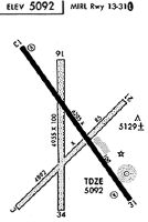
Runways
Runway Summary
| Runways: | 03/21 13/31 17/35 |
| Longest Runway: | 13/31 is 6200 ft (1890 m) long |
| Runways with an Instrument Approach: |
POY Airport Runway Details
| Runway 03/21 | 2623 ft x 100 ft (799 m x 30 m) | |
| Runway Length Source: | 3RD PARTY SURVEY as of 07/12/2009 | |
| Surface: | Turf/Dirt - Fair condition - No special surface treatment | |
Runway 03 |
Runway 21 |
|
Elevation: |
5037.0 | 5055.0 |
Latitude: |
44-51-42.3945N | 44-52-01.0070N |
Longitude: |
108-47-55.9551W | 108-47-30.6478W |
|
Runway True Alignment: |
044 | 224 |
Glide Path Angle: |
0.0 degrees | 0.0 degrees |
Runway Markings Type: |
None | None |
Runway Markings Condition: |
Fair | Fair |
Object at End: |
FENCE | |
Object Height: |
12 | |
Distance from End: |
252 | |
Object Centerline Offset: |
21 ft. right of centerline |
| Runway 13/31 | 6200 ft x 100 ft (1890 m x 30 m) | |
| Runway Length Source: | 3RD PARTY SURVEY as of 07/12/2009 | |
| Surface: | Turf/Dirt - Fair condition - No special surface treatment | |
| Runway Edge Lights: | Medium Intensity | |
Runway Weight Bearing Capacity (in thousands of pounds) |
||
| Single Wheel Landing Gear: | 15.0 | |
Runway 13 |
Runway 31 |
|
Elevation: |
4997.2 | 5095.7 |
Latitude: |
44-52-33.5996N | 44-51-43.6254N |
Longitude: |
108-47-57.1042W | 108-47-07.4266W |
|
Runway True Alignment: |
145 | 325 |
Glide Path Angle: |
3.0 degrees | 3.0 degrees |
Traffic Pattern: |
Left | Left |
Runway Markings Type: |
Nonprecision Instrument | Nonprecision Instrument |
Runway Markings Condition: |
Good | Good |
Object at End: |
FENCE | |
Object Height: |
25 | |
Distance from End: |
1150 | |
Object Centerline Offset: |
21 ft. right of centerline | |
Visual Glide Slope Indicators: |
2-Light PAPI On Left Side Of Runway | 2-Light PAPI On Left Side Of Runway |
REIL: |
Yes | |
Threshold Crossing Height: |
38 | 36 |
| Runway 17/35 | 2709 ft x 100 ft (826 m x 30 m) | |
| Runway Length Source: | 3RD PARTY SURVEY as of 07/12/2009 | |
| Surface: | Turf/Dirt - Fair condition - No special surface treatment | |
Runway 17 |
Runway 35 |
|
Elevation: |
5037.6 | 5057.8 |
Latitude: |
44-52-09.4620N | 44-51-42.7219N |
Longitude: |
108-47-38.6757W | 108-47-38.7046W |
|
Runway True Alignment: |
180 | 000 |
Glide Path Angle: |
0.0 degrees | 0.0 degrees |
Traffic Pattern: |
Left | Left |
Runway Markings Type: |
None | None |
Runway Markings Condition: |
Fair | Fair |
Object at End: |
FENCE | |
Object Height: |
10 | |
Distance from End: |
233 | |
Object Centerline Offset: |
21 ft. right of centerline |
Services
Airframe Repair: |
None |
Powerplant Repair: |
None |
Bottled Oxygen: |
None |
Bulk Oxygen: |
None |
Fuel Available: |
100LL, Jet A-1+ |
Landing Fees: |
Yes |
Parking: |
Tiedowns available |
Maps & Diagrams
POY Sectional
Flight Planning
at skyvector.com
at skyvector.com