Location
Latitude: |
44-56-25.0000N (44.940278) |
Longitude: |
073-05-50.9000W (-73.097472) |
Elevation: |
227.9 feet MSL (69 m MSL) |
Magnetic Variation: |
13.9 W (as of May 2024 from WMM2020 model) |
Time Zone: |
UTC -5.0 (Standard Time) UTC -4.0 (Daylight Savings Time) |
From City: |
03 N.M. W of Highgate, Vermont |
Found On: |
Montreal Chart |
FAA Region: |
ANE |
Contacts
Manager: |
Publicly owned: |
| ROLLIN TEBBETTS 219 N MAIN ST BARRE, VT 05641 802-585-5586 |
STATE OF VERMONT 219 N MAIN ST BARRE, VT 05641 802-279-2647 |
Operations
Airport Status: |
Operational |
Facility Use: |
Public |
Type: |
Airport |
Activation Date: |
07/1970 |
Control tower: |
No |
Attendance (Months/Days/Hours): |
Months/Days/Hours NOV-MAR/M-F/0830-1700 |
Boundary ARTCC: |
ZBW (Boston) |
Responsible ARTCC: |
ZBW (Boston) |
Lighting Schedule: |
SEE RMK |
Segmented Circle Indicator: |
Yes |
Traffic Pattern Altitude (MSL): |
1228 feet (374 m) |
NOTAMs Facility: |
BTV |
NOTAM-D Service: |
Yes |
International Airport of Entry: |
No |
Customs Landing Rights: |
Yes |
Military Landing Rights: |
Yes |
Civil/Military Joint Use: |
No |
Based Aircraft
| Single Engine: | 57 |
| Multi Engine: | 1 |
Annual Operations (as of 06/30/2019)
| Total Operations: | 7030 | |
| GA Local: | 6000 | 85.3% |
| GA Itinerant: | 630 | 9.0% |
| Military Aircraft: | 400 | 5.7% |
Communications
| CTAF: | 122.800 |
| Unicom: | 122.800 |
| Approach: | BURLINGTON 121.1 121.1 121.1 BOSTON ARTCC |
| Departure: | BURLINGTON 121.1 121.1 121.1 BOSTON ARTCC |
| AWOS-3: | 119.025 (802-868-9941) |
- APCH/DEP SVC PRVDD BY BOSTON ARTCC ON FREQS 120.35/342.25 (ST. ALBANS RCAG) WHEN BURLINGTON APCH CTL CLSD.
Fixed Based Operators (FBOs) & Fuel
(Click on a business for detail)
Please help us keep this information up to date. This is a FREE SERVICE just like everything else on Airport Guide! If you see that a business needs to be added, modified, or deleted please fill out our Update Form.
To add, modify, or delete a business click here.
Please help us keep this information up to date. This is a FREE SERVICE just like everything else on Airport Guide! If you see that a business needs to be added, modified, or deleted please fill out our Update Form.
Area Code: 802 |
| Business Name | Frequency | Phone | Fuel Grade |
|---|
Flight Service Stations
| Primary | Alternate | |
| FSS on Field: | N | |
| FSS Name (ID): | Burlington(BTV) | |
| Frequency: | ||
| Toll Free Phone: | 1-800-WX-BRIEF |
Instrument Procedures / Charts
FAA Terminal Procedures valid from 0901Z 03/21/24 to 0901Z 04/18/24.
There are various types of charts available for an airport. They are listed in the Page Type column. Here is a legend for those types:
APD - Airport Diagram
DP - Departure Procedure Charts
HOT - Hot Spots
IAP - Instrument Approach Procedure Charts
MIN - Minimums
STAR - Standard Terminal Arrival Charts
| Page Type | Page Name | Volume | Action Since Last Cycle |
|---|---|---|---|
| IAP | RNAV (GPS) RWY 01 | NE-1 | |
| IAP | RNAV (GPS) RWY 19 | NE-1 | |
| MIN | ALTERNATE MINIMUMS | NE-1 | |
| MIN | TAKEOFF MINIMUMS | NE-1 |
Terminal Procedures are only available for airports in several countries with more being added all the time. If you are looking for a specific country's charts, please send an email to support(at)airportguide.com stating the country name. This will be used to prioritize the implementation.
Navigation Aids (Navaids) near KFSO
| Dist (NM) | ID | Morse Code | Name | Type | Freq | True Hdg | Mag Hdg |
|---|---|---|---|---|---|---|---|
| 21.2 | YJN | _ . _ _ . _ _ _ _ . | St Jean | VOR-DME | 115.80 | 333 | 347 |
| 21.2 | YJN | St-Jean | VORTAC | 115.80 | 333 | 347 | |
| 23.7 | PLB | . _ _ . . _ . . _ . . . | Plattsburgh | VORTAC | 116.90 | 229 | 243 |
| 25.3 | BT | _ . . . _ | Herro | NDB | 382 | 194 | 208 |
| 26.4 | I6R | Bromont | DME | 110.70 | 35 | 49 | |
| 27.9 | BJA | _ . . . . _ _ _ . _ | Burlington | TACAN | 112.40 | 185 | 199 |
| 28.3 | BTV | _ . . . _ . . . _ | Burlington | VOT | 109.00 | 185 | 199 |
| 32.8 | BTV | _ . . . _ . . . _ | Burlington | VOR-DME | 117.50 | 186 | 200 |
| 38.9 | ZHU | Hauts-Bois | NDB | 407 | 344 | 358 | |
| 41.3 | IOA | Montreal Dorval Intl | DME | 110.50 | 319 | 333 | |
| 42.1 | ZDV | Valois | NDB | 201 | 317 | 331 | |
| 42.2 | ZUL | Rockland | NDB | 348 | 326 | 340 | |
| 42.2 | IUL | Montreal | DME | 109.30 | 318 | 332 | |
| 43.2 | ZMT | Jarry | NDB | 284 | 327 | 341 | |
| 44.5 | UL | Montreal | NDB | 248 | 314 | 328 | |
| 51.9 | SLK | . . . . _ . . _ . _ | Briel | NDB | 395 | 237 | 251 |
| 51.9 | SL | . . . . _ . . | Briel | NDB | 395 | 237 | 251 |
| 52.5 | LLX | . _ . . . _ . . _ . . _ | Lyndonville | NDB | 353 | 119 | 133 |
| 54.8 | YUL | _ . _ _ . . _ . _ . . | Montreal | VOR-DME | 116.30 | 318 | 332 |
| 57.8 | SLK | . . . . _ . . _ . _ | Saranac Lake | DME | 109.2 | 235 | 249 |
Nearby Airports with Fuel
Notices to Airmen (NOTAMS)
Remarks
| A110-1 | RWY CONDS MAY NOT BE MNT OR RPRTD WHEN ARPT IS UNATNDD. |
| A110-2 | MIL EQPT MAY BE NEAR RWY. |
| A110-5 | SEAGULLS INVOF ARPT. |
| A110-6 | FOR CD CTC BURLINGTON APCH AT 802-657-4413, WHEN APCH CLSD CTC BOSTON ARTCC AT 603-879-6859. |
| A70-FUEL-10 | 0LL FUEL AVBL 24 HRS SELF-SERVE. AFT HRS SELF-SERVE FUEL KIOSK DOES NOT ACPT MASTERCARD. |
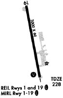
| A81-APT | DUSK-DAWN. ACTVT REIL RWYS 01 & 19; PAPI RWY 01; MIRL RWY 01/19 - CTAF. |
Runways
Runway Summary
| Runways: | 01/19 |
| Longest Runway: | 01/19 is 3001 ft (915 m) long |
| Runways with an Instrument Approach: |
KFSO Airport Runway Details
| Runway 01/19 | 3001 ft x 60 ft (915 m x 18 m) | |
| Runway Length Source: | 3RD PARTY SURVEY as of 08/13/2016 | |
| Surface: | Asphalt - Good condition - No special surface treatment | |
| Runway Edge Lights: | Medium Intensity | |
Runway Weight Bearing Capacity (in thousands of pounds) |
||
| Single Wheel Landing Gear: | 12.5 | |
Runway 01 |
Runway 19 |
|
Elevation: |
227.6 | 227.7 |
Latitude: |
44-56-10.4361N | 44-56-39.5701N |
Longitude: |
073-05-47.0395W | 073-05-54.6672W |
|
Runway True Alignment: |
349 | 169 |
Glide Path Angle: |
4.0 degrees | 0.0 degrees |
Traffic Pattern: |
Left | Left |
Runway Markings Type: |
Nonprecision Instrument | Nonprecision Instrument |
Runway Markings Condition: |
Good | Good |
Object at End: |
TREES | TREES |
Object Height: |
93 | 27 |
Distance from End: |
1771 | 580 |
Object Centerline Offset: |
250 ft. left of centerline | 27 ft. right of centerline |
Visual Glide Slope Indicators: |
2-Light PAPI On Left Side Of Runway | |
REIL: |
Yes | Yes |
Threshold Crossing Height: |
40 |
Services
Airframe Repair: |
Major |
Powerplant Repair: |
Major |
Bottled Oxygen: |
None |
Bulk Oxygen: |
None |
Fuel Available: |
100LL, Jet A, Jet A+ |
Landing Fees: |
No |
Parking: |
Hangars and tiedowns available |
Maps & Diagrams
KFSO Sectional
Flight Planning
at skyvector.com
at skyvector.com