Location
Latitude: |
36-28-30.7480N (36.475208) |
Longitude: |
082-24-26.6950W (-82.407415) |
Elevation: |
1518.7 feet MSL (463 m MSL) |
Magnetic Variation: |
7.1 W (as of May 2024 from WMM2020 model) |
Time Zone: |
UTC -5.0 (Standard Time) UTC -4.0 (Daylight Savings Time) |
From City: |
12 N.M. SW of Bristol/Johnson/Kingsport, Tennessee |
Found On: |
Cincinnati Chart |
FAA Region: |
ASO |
Contacts
Manager: |
Publicly owned: |
| GENE COSSEY 2525 HWY 75, SUITE 301 BLOUNTVILLE, TN 37617 (423) 325-6001 |
BRISTOL JOHNSON KINGSPORT 2525 HWY 75, SUITE 301 BLOUNTVILLE, TN 37617 (423) 325-6000 |
Operations
Airport Status: |
Operational |
Facility Use: |
Public |
Type: |
Airport |
Activation Date: |
12/1937 |
Control tower: |
Yes |
Attendance (Months/Days/Hours): |
Months/Days/Hours ALL/ALL/ALL |
Boundary ARTCC: |
ZTL (Atlanta) |
Responsible ARTCC: |
ZTL (Atlanta) |
Lighting Schedule: |
SS-SR |
Segmented Circle Indicator: |
Yes |
Traffic Pattern Altitude (MSL): |
2519 feet (768 m) |
NOTAMs Facility: |
TRI |
NOTAM-D Service: |
Yes |
International Airport of Entry: |
No |
Customs Landing Rights: |
Yes |
Military Landing Rights: |
Yes |
Civil/Military Joint Use: |
No |
Aircraft Rescue and Firefighting: |
Class I ARFF Index: B Air Carrier Service: Scheduled Certification Date: 05/1973 |
Based Aircraft
| Single Engine: | 31 |
| Multi Engine: | 8 |
| Jet Engine: | 12 |
| GA Helicopters: | 2 |
Annual Operations (as of 03/31/2023)
| Total Operations: | 49790 | |
| Commercial: | 4448 | 8.9% |
| Air Taxi: | 6631 | 13.3% |
| GA Local: | 17044 | 34.2% |
| GA Itinerant: | 19091 | 38.3% |
| Military Aircraft: | 2576 | 5.2% |
Communications
| CTAF: | 119.500 |
| Unicom: | 122.950 |
| Tower: | TRI CITY 119.5 257.8 Hrs: 0600-0000 |
| Ground: | 121.7 348.6 |
| Approach: | TRI CITY 125.5 ;228-046 134.425 ;047-227 317.5 ;228-046 349.0 ;047-227 Hrs: 0600-0000 ATLANTA ARTCC 128.05 Hrs: 0000-0600 |
| Departure: | TRI CITY 125.5 ;228-046 134.425 ;047-227 317.5 ;228-046 349.0 ;047-227 Hrs: 0600-0000 ATLANTA ARTCC 128.05 Hrs: 0000-0600 |
| ATIS: | 118.25 Hrs: 24 |
| ASOS: | 118.25 (423-279-0363) |
| EMERG: | 243.0 |
| EMERG: | 121.5 |
| TRSA: | 317.5 ;228-046 |
| TRSA: | 125.5 ;228-046 |
| TRSA: | 349.0 ;047-227 |
| TRSA: | 134.425 ;047-227 |
- APCH/DEP SVC PRVDD BY ATLANTA ARTCC ON FREQS 127.85/269.3 (GLADE SPRINGS RCAG) WHEN TRI CITY APCH CTL CLSD.
Fixed Based Operators (FBOs) & Fuel
(Click on a business for detail)
Please help us keep this information up to date. This is a FREE SERVICE just like everything else on Airport Guide! If you see that a business needs to be added, modified, or deleted please fill out our Update Form.
To add, modify, or delete a business click here.
Please help us keep this information up to date. This is a FREE SERVICE just like everything else on Airport Guide! If you see that a business needs to be added, modified, or deleted please fill out our Update Form.
Area Code: 423 |
| Business Name | Frequency | Phone | Fuel Grade |
|---|---|---|---|
| Tri-City Aviation
Update FBO info |
Unicom 122.95 | 325-6261 | 100LL, Jet A |
Flight Service Stations
| Primary | Alternate | |
| FSS on Field: | ||
| FSS Name (ID): | Nashville(BNA) | |
| Frequency: | ||
| Toll Free Phone: | 1-800-WX-BRIEF |
Instrument Procedures / Charts
FAA Terminal Procedures valid from 0901Z 05/16/24 to 0901Z 06/13/24.
There are various types of charts available for an airport. They are listed in the Page Type column. Here is a legend for those types:
APD - Airport Diagram
DP - Departure Procedure Charts
HOT - Hot Spots
IAP - Instrument Approach Procedure Charts
MIN - Minimums
STAR - Standard Terminal Arrival Charts
| Page Type | Page Name | Volume | Action Since Last Cycle |
|---|---|---|---|
| APD | AIRPORT DIAGRAM | SE-1 | |
| DP | KINGS TWO | SE-1 | |
| DP | KINGS TWO[DELIMITER] CONT.1 | SE-1 | |
| IAP | ILS OR LOC RWY 05 | SE-1 | |
| IAP | ILS OR LOC RWY 23 | SE-1 | |
| IAP | ILS RWY 23 (CAT II) | SE-1 | |
| IAP | ILS RWY 23 (SA CAT I) | SE-1 | |
| IAP | RNAV (GPS) RWY 05 | SE-1 | |
| IAP | RNAV (GPS) RWY 09 | SE-1 | |
| IAP | RNAV (GPS) RWY 23 | SE-1 | |
| IAP | RNAV (GPS) RWY 27 | SE-1 | |
| MIN | ALTERNATE MINIMUMS | SE-1 | |
| MIN | TAKEOFF MINIMUMS | SE-1 | |
| ODP | TRICITIES THREE (OBSTACLE) | SE-1 | |
| ODP | TRICITIES THREE (OBSTACLE)[DELIMITER] CONT.1 | SE-1 |
Terminal Procedures are only available for airports in several countries with more being added all the time. If you are looking for a specific country's charts, please send an email to support(at)airportguide.com stating the country name. This will be used to prioritize the implementation.
Navigation Aids (Navaids) near TRI
| Dist (NM) | ID | Morse Code | Name | Type | Freq | True Hdg | Mag Hdg |
|---|---|---|---|---|---|---|---|
| 6.3 | BO | _ . . . _ _ _ | Booie | NDB | 221 | 223 | 230 |
| 6.5 | TR | _ . _ . | Mocca | NDB | 299 | 41 | 48 |
| 11.6 | EZT | . _ _ . . _ | Elizabethton | NDB | 275 | 145 | 152 |
| 13.6 | HMV | . . . . _ _ . . . _ | Holston Mountain | VORTAC | 114.60 | 99 | 106 |
| 23.0 | RVN | . _ . . . . _ _ . | Rogersville | NDB | 329 | 267 | 274 |
| 26.3 | GZG | _ _ . _ _ . . _ _ . | Glade Spring | VOR-DME | 110.20 | 36 | 43 |
| 27.0 | VJ | . . . _ . _ _ _ | Whine | NDB | 236 | 54 | 61 |
| 31.0 | DYQ | _ . . _ . _ _ _ _ . _ | Dulaney | NDB | 263 | 229 | 236 |
| 32.0 | BAR | _ . . . . _ . _ . | Hemlock | NDB | 320 | 126 | 133 |
| 51.6 | SOT | . . . _ _ _ _ | Snowbird | VORTAC | 108.80 | 217 | 224 |
| 52.4 | JUH | . _ _ _ . . _ . . . . | Ashee | NDB | 410 | 92 | 99 |
| 55.7 | MRN | _ _ . _ . _ . | Lenoir | FAN MARKER | 136 | 143 | |
| 56.1 | JXT | . _ _ _ _ . . _ _ | Jefferson | NDB | 346 | 247 | 254 |
| 57.2 | IM | . . _ _ | Keans | NDB | 357 | 188 | 195 |
| 58.1 | FIQ | . . _ . . . _ _ . _ | Fiddlers | NDB | 391 | 141 | 148 |
| 62.0 | MKJ | _ _ _ . _ . _ _ _ | Suzze | NDB | 335 | 64 | 72 |
| 64.5 | SUG | . . . . . _ _ _ . | Sugarloaf Mountain | VORTAC | 112.20 | 173 | 180 |
| 66.1 | HKY | . . . . _ . _ _ . _ _ | Hickory Regional | VOT | 110.00 | 131 | 138 |
| 66.9 | UKF | . . _ _ . _ . . _ . | Wilki | NDB | 209 | 108 | 116 |
| 67.2 | BZM | _ . . . _ _ . . _ _ | Barretts Mountain | VOR-DME | 113.75 | 122 | 129 |
Nearby Airports with Fuel
Notices to Airmen (NOTAMS)
Remarks
| A11 | CITIES OF BRISTOL, TN; BRISTOL, VA; JOHNSON CITY & KINGSPORT, TN; COUNTIES OF WASHINGTON & SULLIVAN. TRI CITIES AIRPORT AUTHORITY SETS POLICY AND HAS FINANCIAL AUTHORITY FOR THE AIRPORT. |
| A110-1 | FOR CD IF UNA TO CTC ON FSS FREQ, CTC ATLANTA ARTCC AT 770-210-7692. |
| A43-27 | PAPI RWY 27 UNAVBL WHEN TWR CLSD. |
| E80 | US CUSTOMS USER FEE ARPT. |
Runways
Runway Summary
| Runways: | 05/23 09/27 |
| Longest Runway: | 05/23 is 8000 ft (2438 m) long |
| Runways with an Instrument Approach: | 05, 23 |
TRI Airport Runway Details
| Runway 05/23 | 8000 ft x 150 ft (2438 m x 46 m) | |
| Runway Length Source: | 3RD PARTY SURVEY as of 02/08/2010 | |
| Surface: | Asphalt - Good condition - Saw-cut or plastic grooved | |
| Runway Pavement Class: | 44 /F/A/X/T | |
| Runway Edge Lights: | High Intensity | |
Runway Weight Bearing Capacity (in thousands of pounds) |
||
| Single Wheel Landing Gear: | 112.0 | |
| Dual Wheel Landing Gear: | 185.0 | |
| Dual Tandem Wheel Landing Gear: | 336.0 | |
Runway 05 |
Runway 23 |
|
Elevation: |
1488.2 | 1517.7 |
Latitude: |
36-27-55.2290N | 36-28-53.4830N |
Longitude: |
082-25-08.8136W | 082-24-02.5586W |
|
Runway True Alignment: |
043 | 223 |
ILS Type: |
ILS | ILS |
Glide Path Angle: |
3.0 degrees | 3.0 degrees |
Traffic Pattern: |
Left | Left |
Runway Markings Type: |
Precision Instrument | Precision Instrument |
Runway Markings Condition: |
Good | Good |
Object at End: |
TREES | TREES |
Object Height: |
142 | 47 |
Distance from End: |
5040 | 1900 |
Object Centerline Offset: |
1037 ft. left of centerline | 650 ft. right of centerline |
Visual Glide Slope Indicators: |
4-Light PAPI On Left Side Of Runway | 4-Light PAPI On Right Side Of Runway |
Runway Visual Range (RVR): |
Touchdown, Rollout | Touchdown, Rollout |
Approach Light System: |
Standard 2,400 Foot High Intensity Approach Lighting System With Sequenced Flashers, Cat. II or III Config. | |
REIL: |
Yes | |
Touchdown Lights: |
No | Yes |
Centerline Lights: |
Yes | Yes |
Threshold Crossing Height: |
55 | 55 |
Declared Distances |
||
Take Off Run Avbl. (TORA): |
8000 | 8000 |
Take Off Distance Avbl. (TODA): |
8000 | 8000 |
Actual Stop Dist. Avbl. (ASDA): |
8000 | 8000 |
Landing Dist. Avbl. (LDA): |
8000 | 8000 |
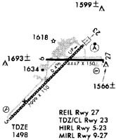
| Runway 09/27 | 4442 ft x 150 ft (1354 m x 46 m) | |
| Runway Length Source: | 3RD PARTY SURVEY as of 02/08/2010 | |
| Surface: | Asphalt - Good condition - No special surface treatment | |
| Runway Pavement Class: | 6 /F/B/X/T | |
| Runway Edge Lights: | Medium Intensity | |
Runway Weight Bearing Capacity (in thousands of pounds) |
||
| Single Wheel Landing Gear: | 21.5 | |
Runway 09 |
Runway 27 |
|
Elevation: |
1518.7 | 1508.6 |
Latitude: |
36-28-41.8939N | 36-28-42.6262N |
Longitude: |
082-24-37.6932W | 082-23-43.3108W |
|
Runway True Alignment: |
089 | 269 |
Glide Path Angle: |
0.0 degrees | 3.0 degrees |
Traffic Pattern: |
Left | Left |
Runway Markings Type: |
Nonprecision Instrument | Nonprecision Instrument |
Runway Markings Condition: |
Good | Good |
Object Centerline Offset: |
1037 ft. left of centerline | 650 ft. right of centerline |
Visual Glide Slope Indicators: |
4-Light PAPI On Left Side Of Runway | |
REIL: |
Yes | |
Threshold Crossing Height: |
32 | |
Threshold Elevation: |
1508.1 | |
Displaced Threshold: |
127 | |
Threshold Latitude: |
36-28-42.6046N | |
Threshold Longitude: |
082-23-44.8683W | |
Declared Distances |
||
Take Off Run Avbl. (TORA): |
4442 | 4442 |
Take Off Distance Avbl. (TODA): |
4442 | 4442 |
Actual Stop Dist. Avbl. (ASDA): |
4320 | 4183 |
Landing Dist. Avbl. (LDA): |
4320 | 4056 |
Services
Airframe Repair: |
Major |
Powerplant Repair: |
Major |
Bottled Oxygen: |
High Pressure / Low Pressure |
Bulk Oxygen: |
High Pressure / Low Pressure |
Fuel Available: |
100LL, Jet A+ |
Landing Fees: |
No |
Parking: |
Tiedowns available |
Maps & Diagrams
TRI Sectional
Flight Planning
at skyvector.com
at skyvector.com