Location
Latitude: |
34-10-28.2470N (34.174513) |
Longitude: |
091-56-08.1752W (-91.935604) |
Elevation: |
205.7 feet MSL (63 m MSL) |
Magnetic Variation: |
0.5 W (as of April 2024 from WMM2020 model) |
Time Zone: |
UTC -6.0 (Standard Time) UTC -5.0 (Daylight Savings Time) |
From City: |
04 N.M. SE of Pine Bluff, Arkansas |
Found On: |
Memphis Chart |
FAA Region: |
ASW |
Contacts
Manager: |
Publicly owned: |
| DOUG HALE PO BOX 7625 PINE BLUFF, AR 71611 870-534-4131 |
CITY OF PINE BLUFF 200 E. 8TH ST. PINE BLUFF, AR 71601 870-730-2000 |
Operations
Airport Status: |
Operational |
Facility Use: |
Public |
Type: |
Airport |
Activation Date: |
06/1941 |
Control tower: |
No |
Attendance (Months/Days/Hours): |
Months/Days/Hours ALL/ALL/0800-1800 |
Boundary ARTCC: |
ZME (Memphis) |
Responsible ARTCC: |
ZME (Memphis) |
Lighting Schedule: |
SEE RMK |
Segmented Circle Indicator: |
Yes |
Traffic Pattern Altitude (MSL): |
1206 feet (368 m) |
NOTAMs Facility: |
PBF |
NOTAM-D Service: |
Yes |
International Airport of Entry: |
No |
Customs Landing Rights: |
No |
Military Landing Rights: |
Yes |
Civil/Military Joint Use: |
No |
Based Aircraft
| Single Engine: | 24 |
| Multi Engine: | 4 |
| GA Helicopters: | 2 |
Annual Operations (as of 01/31/2022)
| Total Operations: | 8900 | |
| Air Taxi: | 300 | 3.4% |
| GA Local: | 5000 | 56.2% |
| GA Itinerant: | 3500 | 39.3% |
| Military Aircraft: | 100 | 1.1% |
Communications
| CTAF: | 123.000 |
| Unicom: | 123.000 |
| Approach: | LITTLE ROCK 119.85 119.85 119.85 |
| Departure: | LITTLE ROCK 119.85 119.85 119.85 |
| ASOS: | 120.775 (870-536-0228) |
- DURG TWR CLOSURE AND HRS FSS OPERNL AAS PRVDD ON FREQ 118.4. WHEN FSS CLSD BROADCAST POSITION / INTENTIONS ON FREQ 118.4.
Fixed Based Operators (FBOs) & Fuel
(Click on a business for detail)
Please help us keep this information up to date. This is a FREE SERVICE just like everything else on Airport Guide! If you see that a business needs to be added, modified, or deleted please fill out our Update Form.
To add, modify, or delete a business click here.
Please help us keep this information up to date. This is a FREE SERVICE just like everything else on Airport Guide! If you see that a business needs to be added, modified, or deleted please fill out our Update Form.
Area Code: 870 |
| Business Name | Frequency | Phone | Fuel Grade |
|---|---|---|---|
| Astro Airways
Update FBO info |
536-1297 | ||
| Eagle Airways
Update FBO info |
536-1297 | ||
| Grider Aviation
Update FBO info |
535-3460 | ||
| Pine Bluff Aviation
Update FBO info |
Unicom 123.0 | 534-4131 | 100LL, Jet A |
| Tomlinson Avionics
Update FBO info |
534-0588 |
Flight Service Stations
| Primary | Alternate | |
| FSS on Field: | N | |
| FSS Name (ID): | Jonesboro(JBR) | |
| Frequency: | ||
| Toll Free Phone: | 1-800-WX-BRIEF |
Instrument Procedures / Charts
FAA Terminal Procedures valid from 0901Z 03/21/24 to 0901Z 04/18/24.
There are various types of charts available for an airport. They are listed in the Page Type column. Here is a legend for those types:
APD - Airport Diagram
DP - Departure Procedure Charts
HOT - Hot Spots
IAP - Instrument Approach Procedure Charts
MIN - Minimums
STAR - Standard Terminal Arrival Charts
| Page Type | Page Name | Volume | Action Since Last Cycle |
|---|---|---|---|
| IAP | ILS OR LOC RWY 18 | SC-1 | |
| IAP | RNAV (GPS) RWY 18 | SC-1 | |
| IAP | RNAV (GPS) RWY 36 | SC-1 | |
| MIN | ALTERNATE MINIMUMS | SC-1 | |
| MIN | TAKEOFF MINIMUMS | SC-1 |
Terminal Procedures are only available for airports in several countries with more being added all the time. If you are looking for a specific country's charts, please send an email to support(at)airportguide.com stating the country name. This will be used to prioritize the implementation.
Navigation Aids (Navaids) near PBF
| Dist (NM) | ID | Morse Code | Name | Type | Freq | True Hdg | Mag Hdg |
|---|---|---|---|---|---|---|---|
| 4.4 | PBF | . _ _ . _ . . . . . _ . | Pine Bluff | VOR-DME | 116.00 | 6 | 7 |
| 26.5 | TT | _ _ | Stutt | NDB | 338 | 41 | 42 |
| 32.5 | LIT | . _ . . . . _ | Little Rock | VORTAC | 113.90 | 338 | 338 |
| 34.0 | SGT | . . . _ _ . _ | Stuttgart | NDB | 269 | 30 | 31 |
| 34.9 | LI | . _ . . . . | Lasky | NDB | 353 | 328 | 328 |
| 38.4 | MON | _ _ _ _ _ _ . | Monticello | DME | 111.6 | 163 | 164 |
| 45.9 | LRF | . _ . . . _ . . . _ . | Jacksonville | TACAN | 109.20 | 346 | 346 |
| 46.9 | TYV | _ _ . _ _ . . . _ | Toneyville | NDB | 290 | 354 | 354 |
| 57.5 | DS | _ . . . . . | Cercy | NDB | 375 | 8 | 9 |
| 58.5 | ADF | . _ _ . . . . _ . | Arkadelphia | NDB | 275 | 263 | 263 |
| 59.7 | CWS | _ . _ . . _ _ . . . | Conway | NDB | 302 | 336 | 336 |
| 60.1 | HOT | . . . . _ _ _ _ | Hot Springs | VOR-DME | 110.00 | 288 | 288 |
| 61.5 | GLH | _ _ . . _ . . . . . . | Greenville | VOR-DME | 114.25 | 129 | 130 |
| 63.9 | HO | . . . . _ _ _ | Hossy | NDB | 385 | 283 | 283 |
| 65.4 | MTQ | _ _ _ _ _ . _ | Metcalf | NDB | 359 | 133 | 134 |
| 66.4 | EL | . . _ . . | Lados | NDB | 418 | 216 | 216 |
| 66.9 | UJM | . . _ . _ _ _ _ _ | Marvell | VOR-DME | 109.60 | 68 | 69 |
| 68.3 | ELD | . . _ . . _ . . | El Dorado | VOR-DME | 115.50 | 216 | 216 |
| 74.8 | MPJ | _ _ . _ _ . . _ _ _ | Morrilton | NDB | 410 | 319 | 319 |
| 85.2 | BQP | _ . . . _ _ . _ . _ _ . | Bastrop | NDB | 329 | 178 | 178 |
Nearby Airports with Fuel
Notices to Airmen (NOTAMS)
Remarks
| A110-2 | ARPT CLSD TO ACFT WITH 30 OR MORE PSGRS. |
| A110-3 | MIGRATORY BIRDS INVOF ARPT. |
| A110-6 | NUMEROUS AGRICULTURAL OPNS ON & INVOF ARPT YEAR ROUND. |
| A110-8 | FOR CD CTC MEMPHIS ARTCC AT 901-368-8453/8449. |
| A17 | FOR ARPT ATTENDANT AFT HRS CALL 870-540-9439. |
| A58-36 | TWO +3 FT POSTS 180 FT FM RY END 180 FT R. |
| A70-FUEL-10 | 0LL SELF SERVICE FUEL AVBL 24 HRS WITH CREDIT CARD (100LL & JET A). |
| A81-APT | DUSK-DAWN. ACTVT MIRL RY 18/36 AND MALSR RY 18 - CTAF. |
Runways
Runway Summary
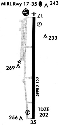
| Runways: | 18/36 |
| Longest Runway: | 18/36 is 5998 ft (1828 m) long |
| Runways with an Instrument Approach: | 18 |
PBF Airport Runway Details
| Runway 18/36 | 5998 ft x 150 ft (1828 m x 46 m) | |
| Runway Length Source: | 3RD PARTY SURVEY as of 08/09/2007 | |
| Surface: | Asphalt - Fair condition - No special surface treatment | |
| Runway Edge Lights: | Medium Intensity | |
Runway Weight Bearing Capacity (in thousands of pounds) |
||
| Single Wheel Landing Gear: | 40.0 | |
| Dual Wheel Landing Gear: | 56.0 | |
| Dual Tandem Wheel Landing Gear: | 90.0 | |
Runway 18 |
Runway 36 |
|
Elevation: |
203.2 | 198.7 |
Latitude: |
34-10-57.9151N | 34-09-58.5788N |
Longitude: |
091-56-08.2961W | 091-56-08.0543W |
|
Runway True Alignment: |
180 | 360 |
ILS Type: |
ILS | |
Glide Path Angle: |
3.0 degrees | 3.0 degrees |
Traffic Pattern: |
Left | Left |
Runway Markings Type: |
Precision Instrument | Precision Instrument |
Runway Markings Condition: |
Good | Good |
Visual Glide Slope Indicators: |
4-Box VASI On Left Side Of Runway | 4-Box VASI On Left Side Of Runway |
Approach Light System: |
1,400 Foot Medium Intensity Approach Lighting System With Runway Alignment Indicator Lights | |
Threshold Crossing Height: |
52 | 52 |
Services
Airframe Repair: |
Major |
Powerplant Repair: |
Major |
Fuel Available: |
100LL |
Landing Fees: |
No |
Parking: |
Tiedowns available |
Maps & Diagrams
PBF Sectional
Flight Planning
at skyvector.com
at skyvector.com