Location
Latitude: |
42-11-25.9000N (42.190528) |
Longitude: |
071-10-22.6000W (-71.172944) |
Elevation: |
49.2 feet MSL (15 m MSL) |
Magnetic Variation: |
14.1 W (as of May 2024 from WMM2020 model) |
Time Zone: |
UTC -5.0 (Standard Time) UTC -4.0 (Daylight Savings Time) |
From City: |
02 N.M. E of Norwood, Massachusetts |
Found On: |
New York Chart |
FAA Region: |
ANE |
Contacts
Manager: |
Publicly owned: |
| MARK RAYMOND 111 ACCESS RD NORWOOD, MA 02062 781-255-5615 |
TOWN OF NORWOOD 566 WASHINGTON ST NORWOOD, MA 02062 781-762-1240 |
Operations
Airport Status: |
Operational |
Facility Use: |
Public |
Type: |
Airport |
Activation Date: |
03/1943 |
Control tower: |
Yes |
Attendance (Months/Days/Hours): |
Months/Days/Hours ALL/MON - FRI/0800-1700 |
Boundary ARTCC: |
ZBW (Boston) |
Responsible ARTCC: |
ZBW (Boston) |
Lighting Schedule: |
SEE RMK |
Segmented Circle Indicator: |
No |
Traffic Pattern Altitude (MSL): |
1049 feet (320 m) |
NOTAMs Facility: |
OWD |
NOTAM-D Service: |
Yes |
International Airport of Entry: |
No |
Customs Landing Rights: |
No |
Military Landing Rights: |
Yes |
Civil/Military Joint Use: |
No |
Based Aircraft
| Single Engine: | 74 |
| Multi Engine: | 6 |
| Jet Engine: | 6 |
| GA Helicopters: | 14 |
Annual Operations (as of 01/31/2020)
| Total Operations: | 58628 | |
| Air Taxi: | 5057 | 8.6% |
| GA Local: | 24234 | 41.3% |
| GA Itinerant: | 29242 | 49.9% |
| Military Aircraft: | 95 | 0.2% |
Communications
| CTAF: | 126.000 |
| Tower: | NORWOOD 126.0 Hrs: 0700-2000 1 NOV - 30 APR, 0700-2200 1 MAY - 31 OCT |
| Clearance Del.: | 121.8 |
| Ground: | 121.8 |
| Approach: | BOSTON |
| Departure: | BOSTON |
| ATIS: | 119.95 Hrs: 24 |
| ASOS: | 119.95 (781-762-4314) |
| EMERG: | 121.5 |
Fixed Based Operators (FBOs) & Fuel
(Click on a business for detail)
Please help us keep this information up to date. This is a FREE SERVICE just like everything else on Airport Guide! If you see that a business needs to be added, modified, or deleted please fill out our Update Form.
To add, modify, or delete a business click here.
Please help us keep this information up to date. This is a FREE SERVICE just like everything else on Airport Guide! If you see that a business needs to be added, modified, or deleted please fill out our Update Form.
Area Code: 781 |
| Business Name | Frequency | Phone | Fuel Grade |
|---|---|---|---|
| Eastern Air Center, Inc.
Update FBO info |
Unicom 122.95 | 769-8680, 800-370-8680 | 100LL, Jet A |
| Norwood Air
Update FBO info |
769-5054 | ||
| Wiggins Airways, Inc.
Update FBO info |
Unicom 123.5 | 762-5690 ext. 252 | 100LL, Jet A |
Flight Service Stations
| Primary | Alternate | |
| FSS on Field: | N | |
| FSS Name (ID): | Bridgeport(BDR) | |
| Frequency: | ||
| Toll Free Phone: | 1-800-WX-BRIEF |
Instrument Procedures / Charts
FAA Terminal Procedures valid from 0901Z 03/21/24 to 0901Z 04/18/24.
There are various types of charts available for an airport. They are listed in the Page Type column. Here is a legend for those types:
APD - Airport Diagram
DP - Departure Procedure Charts
HOT - Hot Spots
IAP - Instrument Approach Procedure Charts
MIN - Minimums
STAR - Standard Terminal Arrival Charts
| Page Type | Page Name | Volume | Action Since Last Cycle |
|---|---|---|---|
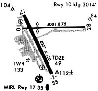
| APD | AIRPORT DIAGRAM | NE-1 | |
| DP | NORWOOD FIVE | NE-1 | Changed |
| DP | NORWOOD FIVE[DELIMITER] CONT.1 | NE-1 | Changed |
| IAP | LOC RWY 35 | NE-1 | |
| IAP | RNAV (GPS) RWY 35 | NE-1 | |
| LAH | LAHSO | NE-1 | |
| MIN | ALTERNATE MINIMUMS | NE-1 | |
| MIN | TAKEOFF MINIMUMS | NE-1 | Changed |
| STAR | WOONS TWO | NE-1 |
Terminal Procedures are only available for airports in several countries with more being added all the time. If you are looking for a specific country's charts, please send an email to support(at)airportguide.com stating the country name. This will be used to prioritize the implementation.
Navigation Aids (Navaids) near OWD
| Dist (NM) | ID | Morse Code | Name | Type | Freq | True Hdg | Mag Hdg |
|---|---|---|---|---|---|---|---|
| 4.7 | OW | _ _ _ . _ _ | Stoge | NDB | 397 | 155 | 169 |
| 11.3 | IHM | . . . . . . _ _ | Mansfield | NDB | 220 | 185 | 199 |
| 12.9 | BOS | _ . . . _ _ _ . . . | Boston | VOT | 111.00 | 39 | 53 |
| 12.9 | BOS | _ . . . _ _ _ . . . | Boston | VOR-DME | 112.70 | 39 | 53 |
| 15.9 | SKR | . . . _ . _ . _ . | Shaker Hill | NDB | 251 | 359 | 373 |
| 17.3 | BED | _ . . . . _ . . | Bedford | VOT | 110.00 | 342 | 356 |
| 18.2 | LQ | . _ . . _ _ . _ | Lyndy | NDB | 382 | 30 | 44 |
| 19.8 | BE | _ . . . . | Bedds | NDB | 332 | 331 | 345 |
| 20.2 | TAN | _ . _ _ . | Taunton | NDB | 227 | 159 | 173 |
| 22.8 | IMR | . . _ _ . _ . | Marshfield | NDB | 368 | 103 | 117 |
| 24.2 | AR | . _ . _ . | Armin | NDB | 356 | 199 | 213 |
| 27.2 | BVY | _ . . . . . . _ _ . _ _ | Beverly | FAN MARKER | 21 | 35 | |
| 27.2 | LW | . _ . . . _ _ | Haget | NDB | 402 | 357 | 371 |
| 30.2 | PVD | . _ _ . . . . _ _ . . | Providence | VOT | 108.20 | 202 | 216 |
| 30.2 | PVD | . _ _ . . . . _ _ . . | Providence | VOR-DME | 115.60 | 202 | 216 |
| 31.2 | ORH | _ _ _ . _ . . . . . | Worcester | VOT | 108.20 | 278 | 292 |
| 33.1 | PUT | . _ _ . . . _ _ | Putnam | VOR-DME | 117.40 | 244 | 258 |
| 33.2 | LWM | . _ . . . _ _ _ _ | Lawrence | DME | 112.5 | 5 | 19 |
| 33.7 | FIT | . . _ . . . _ | Fitchburg | NDB | 365 | 310 | 324 |
| 41.6 | MHT | _ _ . . . . _ | Manchester | VOR-DME | 114.40 | 348 | 362 |
Nearby Airports with Fuel
Notices to Airmen (NOTAMS)
Remarks
| A110-1 | 1199 FT /1349 FT MSL/ AND 1249 FT /1349 FT MSL/ TV TWR 8 NM NNW. 1063.5 FT /1184 FT MSL/ TWR 8.5 NM NNW. |
| A110-2 | ALL ACFT EXCEEDING 87 EFF PERCEIVED NOISE LEVEL IN DBS OR 75 DBS, AS MEASURED IN PART 36 PROHIBITED FM USING ARPT. |
| A110-3 | 125 FT FLAGPOLE 1 MI NW OF RWY 17 APCH. |
| A110-4 | GATE 2 TXL LTD TO ACFT WITH WINGSPANS OF 50 FT OR LESS. GATE 3 TXL LTD TO ACFT WITH WINGSPANS OF 45 FT OR LESS. |
| A110-5 | BIRD ACTVTY & WILDLIFE INVOF ARPT. |
| A110-6 | SN REMOVAL EQUIP BLDG (ABUTTING SOUTH APRON). |
| A110-7 | LDG FEES FOR TSNT FIXED-WING ACFT WITH MORE THAN 5000 LBS MAX TOG, AS WELL AS TSNT HELS REGARDLESS OF WT. |
| A23-28 | & 35 RIGHT TFC FOR TGL ONLY. |
| A57-10 | APCH RATIO 50:1 TO DTHR. |
| A81-APT | WHEN ATCT CLSD ACTVT MALSF RWY 35; PAPI RWYS 10, 17 & 35; MIRL 17/35 - CTAF. |
| E111 | FILED FOR RECORD PURPOSES ONLY. |
Runways
Runway Summary
| Runways: | 10/28 17/35 |
| Longest Runway: | 17/35 is 4007 ft (1221 m) long |
| Runways with an Instrument Approach: | 35 |
OWD Airport Runway Details
| Runway 10/28 | 3995 ft x 75 ft (1218 m x 23 m) | |
| Runway Length Source: | 3RD PARTY SURVEY as of 11/16/2017 | |
| Surface: | Asphalt - Good condition - No special surface treatment | |
Runway Weight Bearing Capacity (in thousands of pounds) |
||
| Single Wheel Landing Gear: | 58.0 | |
| Dual Wheel Landing Gear: | 69.0 | |
Runway 10 |
Runway 28 |
|
Elevation: |
48.4 | 46.1 |
Latitude: |
42-11-31.5994N | 42-11-32.4482N |
Longitude: |
071-10-42.6229W | 071-09-49.5658W |
|
Runway True Alignment: |
089 | 269 |
Glide Path Angle: |
4.0 degrees | 0.0 degrees |
Traffic Pattern: |
Left | Right |
Runway Markings Type: |
Basic | Basic |
Runway Markings Condition: |
Good | Good |
Object at End: |
TREES | TREES |
Object Height: |
40 | 40 |
Distance from End: |
1200 | 1000 |
Object Centerline Offset: |
125 ft. left of centerline | 125 ft. right of centerline |
Visual Glide Slope Indicators: |
4-Light PAPI On Right Side Of Runway | |
REIL: |
No | No |
Touchdown Lights: |
No | No |
Centerline Lights: |
No | No |
Threshold Crossing Height: |
25 | |
Threshold Elevation: |
47.8 | 46.2 |
Displaced Threshold: |
987 | 212 |
Threshold Latitude: |
42-11-31.8115N | 42-11-32.4071N |
Threshold Longitude: |
071-10-29.5188W | 071-09-52.3840W |
Declared Distances |
||
Take Off Run Avbl. (TORA): |
3995 | 3995 |
Take Off Distance Avbl. (TODA): |
3995 | 3995 |
Actual Stop Dist. Avbl. (ASDA): |
3782 | 3808 |
Landing Dist. Avbl. (LDA): |
2795 | 3595 |
| Runway 17/35 | 4007 ft x 100 ft (1221 m x 30 m) | |
| Runway Length Source: | 3RD PARTY SURVEY as of 11/16/2017 | |
| Surface: | Asphalt - Good condition - Saw-cut or plastic grooved | |
| Runway Edge Lights: | Medium Intensity | |
Runway Weight Bearing Capacity (in thousands of pounds) |
||
| Single Wheel Landing Gear: | 58.0 | |
| Dual Wheel Landing Gear: | 69.0 | |
Runway 17 |
Runway 35 |
|
Elevation: |
49.2 | 47.1 |
Latitude: |
42-11-37.6458N | 42-11-01.8352N |
Longitude: |
071-10-40.3344W | 071-10-17.6415W |
|
Runway True Alignment: |
155 | 335 |
ILS Type: |
LOC/DME | |
Glide Path Angle: |
3.0 degrees | 3.0 degrees |
Traffic Pattern: |
Left | Right |
Runway Markings Type: |
Nonprecision Instrument | Nonprecision Instrument |
Runway Markings Condition: |
Good | Good |
Object at End: |
TREES | |
Object Height: |
26 | 20 |
Distance from End: |
850 | 1200 |
Object Centerline Offset: |
125 ft. left of centerline | 125 ft. right of centerline |
Visual Glide Slope Indicators: |
4-Light PAPI On Right Side Of Runway | 4-Light PAPI On Left Side Of Runway |
Approach Light System: |
1,400 Foot Medium Intensity Approach Lighting System With Sequenced Flashers | |
REIL: |
No | No |
Touchdown Lights: |
No | No |
Centerline Lights: |
No | No |
Threshold Crossing Height: |
40 | 40 |
Services
Airframe Repair: |
Major |
Powerplant Repair: |
Major |
Bottled Oxygen: |
None |
Bulk Oxygen: |
None |
Fuel Available: |
100LL |
Landing Fees: |
No |
Parking: |
Tiedowns available |
Other Services: |
Parachute rental |
Maps & Diagrams
OWD Sectional
Flight Planning
at skyvector.com
at skyvector.com