Location
Latitude: |
35-23-15.9730N (35.38777) |
Longitude: |
080-42-32.8770W (-80.709133) |
Elevation: |
704.2 feet MSL (215 m MSL) |
Magnetic Variation: |
8.1 W (as of December 2025 from WMM2020 model) |
Time Zone: |
UTC -5.0 (Standard Time) UTC -4.0 (Daylight Savings Time) |
From City: |
07 N.M. W of Concord, North Carolina |
Found On: |
Charlotte Chart |
FAA Region: |
ASO |
Contacts
Manager: |
Publicly owned: |
| DIRK VANDERLEEST 9000 AVIATION BLVD CONCORD, NC 28027 704-920-5912 |
CITY OF CONCORD 9000 AVIATION BLVD CONCORD, NC 28027 704-920-5900 |
Operations
Airport Status: |
Operational |
Facility Use: |
Public |
Type: |
Airport |
Activation Date: |
11/1993 |
Control tower: |
Yes |
Attendance (Months/Days/Hours): |
Months/Days/Hours ALL/ALL/ALL |
Boundary ARTCC: |
ZTL (Atlanta) |
Responsible ARTCC: |
ZTL (Atlanta) |
Lighting Schedule: |
SEE RMK |
Segmented Circle Indicator: |
Yes |
Traffic Pattern Altitude (MSL): |
1704 feet (519 m) |
NOTAMs Facility: |
JQF |
NOTAM-D Service: |
Yes |
Aircraft Rescue and Firefighting: |
Class I ARFF Index: C Air Carrier Service: Scheduled Certification Date: 10/2006 |
Based Aircraft
Annual Operations (as of )
Communications
| CTAF: | 134.650 |
| Unicom: | 122.950 |
| Tower: | CONCORD 134.65 Hrs: 0700-2300 |
| Clearance Del.: | 118.55 |
| Ground: | 121.85 |
| Approach: | CHARLOTTE |
| Departure: | CHARLOTTE |
| ATIS: | 133.675 Hrs: 24 |
| AWOS-3: | 133.675 (704-785-2145) |
Fixed Based Operators (FBOs) & Fuel
(Click on a business for detail)
Please help us keep this information up to date. This is a FREE SERVICE just like everything else on Airport Guide!
Please help us keep this information up to date. This is a FREE SERVICE just like everything else on Airport Guide!
Area Code: 704 |
| Business Name | Frequency | Phone | Fuel Grade |
|---|---|---|---|
| Concord Regional
|
Unicom 122.7 | 793-9000 | 100LL, Jet A |
| Helivision L.L.C.
|
792-1807 | ||
| Spitfire Aviation, Inc.
|
784-3591 | 100LL, Jet A | |
| The Bird Bath
|
800-524-2284 |
Flight Service Stations
| Primary | Alternate | |
| FSS on Field: | N | |
| FSS Name (ID): | Raleigh(RDU) | |
| Frequency: | ||
| Toll Free Phone: | 1-800-WX-BRIEF |
Instrument Procedures / Charts
FAA Terminal Procedures valid from 0901Z 11/27/25 to 0901Z 12/25/25.
There are various types of charts available for an airport. They are listed in the Page Type column. Here is a legend for those types:
APD - Airport Diagram
DP - Departure Procedure Charts
HOT - Hot Spots
IAP - Instrument Approach Procedure Charts
MIN - Minimums
STAR - Standard Terminal Arrival Charts
| Page Type | Page Name | Volume | Action Since Last Cycle |
|---|---|---|---|
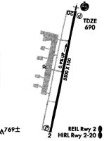
| APD | AIRPORT DIAGRAM | SE-2 | |
| DP | BARMY FIVE (RNAV) | SE-2 | |
| DP | BEAVY SIX (RNAV) | SE-2 | |
| DP | BOBZY FIVE (RNAV) | SE-2 | |
| DP | ESTRR FIVE (RNAV) | SE-2 | |
| DP | ICONS FIVE (RNAV) | SE-2 | |
| DP | JOJJO FIVE (RNAV) | SE-2 | |
| DP | KERMIT FOUR | SE-2 | |
| DP | KERMIT FOUR[DELIMITER] CONT.1 | SE-2 | |
| DP | KILNS FIVE (RNAV) | SE-2 | |
| DP | KNIGHTS THREE | SE-2 | |
| DP | KNIGHTS THREE[DELIMITER] CONT.1 | SE-2 | |
| DP | KRITR SIX (RNAV) | SE-2 | |
| DP | KWEEN FIVE (RNAV) | SE-2 | |
| DP | LILLS THREE (RNAV) | SE-2 | |
| DP | WEAZL FIVE (RNAV) | SE-2 | |
| IAP | ILS OR LOC RWY 20 | SE-2 | |
| IAP | RNAV (GPS) RWY 02 | SE-2 | |
| IAP | RNAV (GPS) RWY 20 | SE-2 | |
| MIN | ALTERNATE MINIMUMS | SE-2 | |
| MIN | TAKEOFF MINIMUMS | SE-2 | |
| STAR | JOOLS ONE (RNAV) | SE-2 | |
| STAR | KABEE THREE (RNAV) | SE-2 | |
| STAR | NASCR ONE (RNAV) | SE-2 |
Terminal Procedures are only available for airports in several countries with more being added all the time. If you are looking for a specific country's charts, please send an email to support(at)airportguide.com stating the country name. This will be used to prioritize the implementation.
Navigation Aids (Navaids) near KJQF
| Dist (NM) | ID | Morse Code | Name | Type | Freq | True Hdg | Mag Hdg |
|---|---|---|---|---|---|---|---|
| 15.6 | CLT | _ . _ . . _ . . _ | Charlotte | VOT | 112.00 | 231 | 239 |
| 16.8 | CLT | _ . _ . . _ . . _ | Charlotte | VOR-DME | 115.00 | 225 | 233 |
| 20.5 | IZN | . . _ _ . . _ . | Lincolnton | NDB | 432 | 296 | 304 |
| 23.3 | RU | . _ . . . _ | Rovdy | NDB | 275 | 27 | 35 |
| 24.9 | GHJ | _ _ . . . . . . _ _ _ | Stonia | NDB | 260 | 241 | 249 |
| 26.1 | TWL | _ . _ _ . _ . . | Wesley | NDB | 204 | 179 | 187 |
| 31.2 | VU | . . . _ . . _ | Aller | NDB | 346 | 78 | 86 |
| 35.0 | UZ | . . _ _ _ . . | Rally | NDB | 227 | 211 | 219 |
| 37.7 | HK | . . . . _ . _ | Tawba | NDB | 332 | 309 | 317 |
| 38.8 | BZM | _ . . . _ _ . . _ _ | Barretts Mountain | VOR-DME | 113.75 | 318 | 326 |
| 39.4 | HKY | . . . . _ . _ _ . _ _ | Hickory Regional | VOT | 110.00 | 302 | 310 |
| 40.6 | LKR | . _ . . _ . _ . _ . | Lancaster | NDB | 400 | 190 | 198 |
| 42.6 | PYG | . _ _ . _ . _ _ _ _ . | Pageland | NDB | 270 | 154 | 162 |
| 43.4 | DCM | _ . . _ . _ . _ _ | Chester | NDB | 220 | 213 | 221 |
| 44.3 | SLP | . . . . _ . . . _ _ . | First River | NDB | 417 | 259 | 267 |
| 47.5 | UKF | . . _ _ . _ . . _ . | Wilki | NDB | 209 | 336 | 344 |
| 48.8 | IN | . . _ . | Reeno | NDB | 317 | 32 | 40 |
| 49.1 | CTF | _ . _ . _ . . _ . | Chesterfield | VOR-DME | 114.55 | 154 | 162 |
| 50.8 | FIQ | . . _ . . . _ _ . _ | Fiddlers | NDB | 391 | 292 | 300 |
| 50.9 | MRN | _ _ . _ . _ . | Lenoir | FAN MARKER | 299 | 307 |
Nearby Airports with Fuel
Notices to Airmen (NOTAMS)
Remarks
| A110-2 | FOR CD WHEN ATCT IS CLSD CTC CLT APCH AT 704-359-0241. |
| A34-02/20 | GROOVED FULL LENGTH ASPHALT. |
| A39-02/20 | PCR VALUE: 450/F/D/X/T |
| A81-APT | WHEN ATCT CLSD; TDZL RWY 20; HIRL RWY 02/20 & REIL RWY 02 PRESET LOW INTST. ACTVT MALSR RWY 20; REIL RWY 02; TDZL RWY 20; HIRL RWY 02/20 - CTAF. PAPI RWY 02 & 20 OPER CONSLY. |
Runways
Runway Summary
| Runways: | 02/20 H1 |
| Longest Runway: | 02/20 is 7402 ft (2256 m) long |
| Runways with an Instrument Approach: | 20 |
KJQF Airport Runway Details
| Runway 02/20 | 7402 ft x 100 ft (2256 m x 30 m) | |
| Runway Length Source: | 3RD PARTY SURVEY as of 08/29/2018 | |
| Surface: | Asphalt - Good condition - Saw-cut or plastic grooved | |
| Runway Edge Lights: | High Intensity | |
Runway Weight Bearing Capacity (in thousands of pounds) |
||
| Dual Wheel Landing Gear: | 171.0 | |
Runway 02 |
Runway 20 |
|
Elevation: |
639.4 | 704.2 |
Latitude: |
35-22-39.9810N | 35-23-51.9640N |
Longitude: |
080-42-40.9906W | 080-42-24.7619W |
|
Runway True Alignment: |
010 | 190 |
ILS Type: |
ILS/DME | |
Glide Path Angle: |
3.5 degrees | 3.0 degrees |
Runway Markings Type: |
Precision Instrument | Precision Instrument |
Runway Markings Condition: |
Good | Good |
Object at End: |
TREES | TREES |
Object Height: |
13 | 127 |
Distance from End: |
281 | 3200 |
Object Centerline Offset: |
248 ft. left of centerline | 500 ft. right of centerline |
Visual Glide Slope Indicators: |
4-Light PAPI On Left Side Of Runway | 4-Light PAPI On Left Side Of Runway |
Approach Light System: |
1,400 Foot Medium Intensity Approach Lighting System With Runway Alignment Indicator Lights | |
REIL: |
Yes | |
Touchdown Lights: |
No | Yes |
Threshold Crossing Height: |
69 | 45 |
Threshold Elevation: |
699.1 | |
Displaced Threshold: |
650 | |
Threshold Latitude: |
35-23-45.6425N | |
Threshold Longitude: |
080-42-26.1872W | |
Declared Distances |
||
Take Off Run Avbl. (TORA): |
7400 | 7400 |
Take Off Distance Avbl. (TODA): |
7400 | 7400 |
Actual Stop Dist. Avbl. (ASDA): |
7400 | 7000 |
Landing Dist. Avbl. (LDA): |
7400 | 6350 |
| Helipad H1 | 50 ft x 50 ft (15 m x 15 m) | |
| Runway Length Source: | ADO as of 05/03/2024 | |
| Surface: | Asphalt - Good condition - No special surface treatment | |
| Runway Edge Lights: | Non-standard lighting system Intensity | |
Helipad H1 |
||
Elevation: |
652.0 | |
Latitude: |
35-22-55.6700N | |
Longitude: |
080-42-45.1600W | |
Glide Path Angle: |
0.0 degrees | 0.0 degrees |
Runway Markings Type: |
Basic | |
Object Centerline Offset: |
248 ft. left of centerline | 500 ft. right of centerline |
Services
Airframe Repair: |
Major |
Powerplant Repair: |
Major |
Bottled Oxygen: |
None |
Bulk Oxygen: |
None |
Fuel Available: |
100LL, Jet A-1+ |
Landing Fees: |
No |
Parking: |
Hangars and tiedowns available |
Ratings and Reviews
Write a review for Concord-Padgett Regional Airport
Maps & Diagrams
KJQF Sectional
Flight Planning
at skyvector.com
at skyvector.com