Location
Latitude: |
35-38-45.1800N (35.645883) |
Longitude: |
080-31-13.0500W (-80.520292) |
Elevation: |
772.3 feet MSL (235 m MSL) |
Magnetic Variation: |
8.2 W (as of April 2024 from WMM2020 model) |
Time Zone: |
UTC -5.0 (Standard Time) UTC -4.0 (Daylight Savings Time) |
From City: |
03 N.M. SW of Salisbury, North Carolina |
Found On: |
Charlotte Chart |
FAA Region: |
ASO |
Contacts
Manager: |
Publicly owned: |
| VALERIE STEELE 3670 AIRPORT LOOP SALISBURY, NC 28147-8921 704-216-7753 |
ROWAN COUNTY 130 W. INNES ST SALISBURY, NC 28144 704-216-8100 |
Operations
Airport Status: |
Operational |
Facility Use: |
Public |
Type: |
Airport |
Activation Date: |
01/1938 |
Control tower: |
No |
Attendance (Months/Days/Hours): |
Months/Days/Hours ALL/ALL/0800-2000 |
Boundary ARTCC: |
ZTL (Atlanta) |
Responsible ARTCC: |
ZTL (Atlanta) |
Lighting Schedule: |
SEE RMK |
Segmented Circle Indicator: |
Yes |
Traffic Pattern Altitude (MSL): |
1772 feet (540 m) |
NOTAMs Facility: |
RUQ |
NOTAM-D Service: |
Yes |
International Airport of Entry: |
No |
Customs Landing Rights: |
No |
Military Landing Rights: |
Yes |
Civil/Military Joint Use: |
No |
Based Aircraft
| Single Engine: | 73 |
| Multi Engine: | 9 |
| Jet Engine: | 3 |
| GA Helicopters: | 4 |
| Military Aircraft: | 10 |
Annual Operations (as of 09/02/2023)
| Total Operations: | 51000 | |
| Air Taxi: | 1000 | 2.0% |
| GA Local: | 20000 | 39.2% |
| GA Itinerant: | 25000 | 49.0% |
| Military Aircraft: | 5000 | 9.8% |
Communications
| CTAF: | 122.725 |
| Unicom: | 122.725 |
| Approach: | CHARLOTTE |
| Departure: | CHARLOTTE |
| AWOS-3: | 118.175 (704-637-6197) |
Fixed Based Operators (FBOs) & Fuel
(Click on a business for detail)
Please help us keep this information up to date. This is a FREE SERVICE just like everything else on Airport Guide! If you see that a business needs to be added, modified, or deleted please fill out our Update Form.
To add, modify, or delete a business click here.
Please help us keep this information up to date. This is a FREE SERVICE just like everything else on Airport Guide! If you see that a business needs to be added, modified, or deleted please fill out our Update Form.
Area Code: 704 |
| Business Name | Frequency | Phone | Fuel Grade |
|---|---|---|---|
| Carolina Aircraft Associates, Inc.
Update FBO info |
Unicom 122.8 | 633-5021 | 100LL, Jet A |
| Hess Aviation
Update FBO info |
636-6649, 633-5021 | 100LL, Jet A |
Flight Service Stations
| Primary | Alternate | |
| FSS on Field: | N | |
| FSS Name (ID): | Raleigh(RDU) | |
| Frequency: | ||
| Toll Free Phone: | 1-800-WX-BRIEF |
Instrument Procedures / Charts
FAA Terminal Procedures valid from 0901Z 03/21/24 to 0901Z 04/18/24.
There are various types of charts available for an airport. They are listed in the Page Type column. Here is a legend for those types:
APD - Airport Diagram
DP - Departure Procedure Charts
HOT - Hot Spots
IAP - Instrument Approach Procedure Charts
MIN - Minimums
STAR - Standard Terminal Arrival Charts
| Page Type | Page Name | Volume | Action Since Last Cycle |
|---|---|---|---|
| APD | AIRPORT DIAGRAM | SE-2 | |
| DP | BARMY FIVE (RNAV) | SE-2 | Changed |
| DP | BEAVY SIX (RNAV) | SE-2 | Changed |
| DP | BOBZY FIVE (RNAV) | SE-2 | Changed |
| DP | ESTRR FIVE (RNAV) | SE-2 | Changed |
| DP | ICONS FIVE (RNAV) | SE-2 | Changed |
| DP | JOJJO FIVE (RNAV) | SE-2 | Changed |
| DP | KERMIT FOUR | SE-2 | Changed |
| DP | KERMIT FOUR[DELIMITER] CONT.1 | SE-2 | Changed |
| DP | KILNS FIVE (RNAV) | SE-2 | Changed |
| DP | KNIGHTS THREE | SE-2 | Changed |
| DP | KNIGHTS THREE[DELIMITER] CONT.1 | SE-2 | Changed |
| DP | KRITR SIX (RNAV) | SE-2 | Changed |
| DP | KWEEN FIVE (RNAV) | SE-2 | Changed |
| DP | LILLS THREE (RNAV) | SE-2 | Changed |
| DP | WEAZL FIVE (RNAV) | SE-2 | Changed |
| IAP | ILS OR LOC RWY 20 | SE-2 | |
| IAP | NDB RWY 20 | SE-2 | |
| IAP | RNAV (GPS) RWY 02 | SE-2 | |
| IAP | RNAV (GPS) RWY 20 | SE-2 | |
| MIN | ALTERNATE MINIMUMS | SE-2 | |
| MIN | TAKEOFF MINIMUMS | SE-2 | |
| STAR | JOOLS ONE (RNAV) | SE-2 | |
| STAR | KABEE THREE (RNAV) | SE-2 | |
| STAR | NASCR FOUR | SE-2 | Changed |
Terminal Procedures are only available for airports in several countries with more being added all the time. If you are looking for a specific country's charts, please send an email to support(at)airportguide.com stating the country name. This will be used to prioritize the implementation.
Navigation Aids (Navaids) near SRW
| Dist (NM) | ID | Morse Code | Name | Type | Freq | True Hdg | Mag Hdg |
|---|---|---|---|---|---|---|---|
| 5.4 | RU | . _ . . . _ | Rovdy | NDB | 275 | 15 | 23 |
| 23.3 | VU | . . . _ . . _ | Aller | NDB | 346 | 113 | 121 |
| 28.4 | IZN | . . _ _ . . _ . | Lincolnton | NDB | 432 | 256 | 264 |
| 30.8 | IN | . . _ . | Reeno | NDB | 317 | 33 | 41 |
| 33.1 | CLT | _ . _ . . _ . . _ | Charlotte | VOT | 112.00 | 220 | 228 |
| 34.5 | CLT | _ . _ . . _ . . _ | Charlotte | VOR-DME | 115.00 | 217 | 225 |
| 35.7 | GSO | _ _ . . . . _ _ _ | Greensboro | VORTAC | 116.20 | 47 | 55 |
| 37.5 | BZM | _ . . . _ _ . . _ _ | Barretts Mountain | VOR-DME | 113.75 | 291 | 299 |
| 39.2 | HK | . . . . _ . _ | Tawba | NDB | 332 | 282 | 290 |
| 39.7 | UKF | . . _ _ . _ . . _ . | Wilki | NDB | 209 | 315 | 323 |
| 41.1 | ZEF | _ _ . . . . . _ . | Zephyr | NDB | 326 | 345 | 353 |
| 41.4 | GHJ | _ _ . . . . . . _ _ _ | Stonia | NDB | 260 | 229 | 237 |
| 42.6 | TWL | _ . _ _ . _ . . | Wesley | NDB | 204 | 192 | 200 |
| 42.8 | HKY | . . . . _ . _ _ . _ _ | Hickory Regional | VOT | 110.00 | 278 | 286 |
| 44.1 | AZW | . _ _ _ . . . _ _ | Mount Airy | NDB | 223 | 358 | 366 |
| 45.3 | LIB | . _ . . . . _ . . . | Liberty | VORTAC | 113.00 | 77 | 86 |
| 49.7 | HB | . . . . _ . . . | Alamm | NDB | 361 | 66 | 75 |
| 52.4 | SDZ | . . . _ . . _ _ . . | Sandhills | VORTAC | 111.80 | 119 | 127 |
| 53.0 | UZ | . . _ _ _ . . | Rally | NDB | 227 | 211 | 219 |
| 54.5 | MRN | _ _ . _ . _ . | Lenoir | FAN MARKER | 279 | 287 |
Nearby Airports with Fuel
Notices to Airmen (NOTAMS)
Remarks
| A110-10 | MAIN TRML APRON GRASS AREA ADJ TO FUEL PUMPS CLSD TO HELS. |
| A110-11 | BE ALERT FOR MIL ROTOR WING TFC. RNG RAMP LCTD W OF RWY. FRQ NGT OPS. |
| A110-12 | CTC KILLDEVIL OPS 10 MIN PRIOR TO LDG. RNG OPS FREQ - 40.700, 126.100, 293.000. |
| A110-13 | FOR CD CTC CHARLOTTE APCH AT 704-359-0241. |
| A110-2 | ADDNL OBSTNS FOR RWY 02; 20 FT BLDG 1100 FT FM THR 100 FT R OF CNTRLN. |
| A110-6 | 24 HR SVC BY REQ. FOR AFT HRS SVC CALL 980-892-2840. |
| A110-7 | TRANSIT MIL FUEL. |
| A110-8 | RMK: ARNG; LTD PRK RAMP CLSD TO ALL TFC EXC MIL ACFT WITH PPR. OPR 1200-2030Z++ MON-FRI EXC HOL. |
| A110-9 | SKY DIVING OPS OVR ARPT; DO NOT OVERFLY ARPT DRG SKY DIVING OPS. |
| A17 | UNATNDD THANKSGIVING AND CHRISTMAS DAY. TO SKED AFT HRS OR HOLIDAY SVC CALL 980-892-2840. |
| A57-02 | APCH RATIO 22:1 AT DSPLCD DUE TO 41 FT TREES 1123 FT FM THR OFFSET 418 LEFT OF CNTRLN. |
| A58-20 | 15 FT TREES 0-200 FT FM THR OFFSET 325 FT LEFT OF CNTRLN. |
| A70-FUEL-A1 | + MIL FUEL A+ CTC KILLDEVIL OPS 24 HR PPR, C 984-661-6506/6507/6557. |
| A70-FUEL-10 | 0LL 24 SELF SERVICE AVBL FOR 100LL WITH CREDIT CARD. |
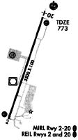
| A81-APT | ACTVT MALSR RWY 20; REIL RWY 02 & 20; PAPI RWY 02 & 20; MIRL RWY 02/20 - CTAF. |
Runways
Runway Summary
| Runways: | 02/20 |
| Longest Runway: | 02/20 is 5501 ft (1677 m) long |
| Runways with an Instrument Approach: | 20 |
SRW Airport Runway Details
| Runway 02/20 | 5501 ft x 100 ft (1677 m x 30 m) | |
| Runway Length Source: | 3RD PARTY SURVEY as of 03/30/2015 | |
| Surface: | Asphalt - Good condition - No special surface treatment | |
| Runway Edge Lights: | Medium Intensity | |
Runway Weight Bearing Capacity (in thousands of pounds) |
||
| Single Wheel Landing Gear: | 45.0 | |
| Dual Wheel Landing Gear: | 55.0 | |
Runway 02 |
Runway 20 |
|
Elevation: |
769.1 | 765.6 |
Latitude: |
35-38-19.0288N | 35-39-11.3300N |
Longitude: |
080-31-22.2231W | 080-31-03.8666W |
|
Runway True Alignment: |
016 | 196 |
ILS Type: |
ILS | |
Glide Path Angle: |
3.0 degrees | 3.0 degrees |
Runway Markings Type: |
Nonprecision Instrument | Precision Instrument |
Runway Markings Condition: |
Good | Good |
Object at End: |
TREES | TREES |
Object Height: |
35 | 23 |
Distance from End: |
814 | 231 |
Object Centerline Offset: |
356 ft. left of centerline | 297 ft. left of centerline |
Visual Glide Slope Indicators: |
2-Light PAPI On Left Side Of Runway | 2-Light PAPI On Left Side Of Runway |
Approach Light System: |
1,400 Foot Medium Intensity Approach Lighting System With Runway Alignment Indicator Lights | |
REIL: |
Yes | Yes |
Threshold Crossing Height: |
34 | 47 |
Threshold Elevation: |
770.5 | |
Displaced Threshold: |
126 | |
Threshold Latitude: |
35-38-20.2296N | |
Threshold Longitude: |
080-31-21.8121W |
Services
Airframe Repair: |
None |
Powerplant Repair: |
None |
Bottled Oxygen: |
None |
Bulk Oxygen: |
None |
Fuel Available: |
100LL, Jet A-1+ |
Landing Fees: |
No |
Parking: |
Tiedowns available |
Maps & Diagrams
SRW Sectional
Flight Planning
at skyvector.com
at skyvector.com