Location
Latitude: |
35-01-14.2960N (35.020638) |
Longitude: |
080-04-37.6230W (-80.077118) |
Elevation: |
299.7 feet MSL (91 m MSL) |
Magnetic Variation: |
8.4 W (as of May 2024 from WMM2020 model) |
Time Zone: |
UTC -5.0 (Standard Time) UTC -4.0 (Daylight Savings Time) |
From City: |
03 N.M. N of Wadesboro, North Carolina |
Found On: |
Charlotte Chart |
FAA Region: |
ASO |
Contacts
Manager: |
Publicly owned: |
| REX EDWARDS 2980 AIRPORT ROAD WADESBORO, NC 28170 (704) 389-0633 |
ANSON COUNTY 101 S. GREENE STREET WADESBORO, NC 28170 704-994-3200 |
Operations
Airport Status: |
Operational |
Facility Use: |
Public |
Type: |
Airport |
Activation Date: |
05/1941 |
Control tower: |
No |
Attendance (Months/Days/Hours): |
Months/Days/Hours ALL/MON-FRI/0830-1700 |
Boundary ARTCC: |
ZTL (Atlanta) |
Responsible ARTCC: |
ZTL (Atlanta) |
Lighting Schedule: |
SEE RMK |
Segmented Circle Indicator: |
Yes |
Traffic Pattern Altitude (MSL): |
1300 feet (396 m) |
NOTAMs Facility: |
RDU |
NOTAM-D Service: |
Yes |
International Airport of Entry: |
No |
Customs Landing Rights: |
No |
Military Landing Rights: |
No |
Civil/Military Joint Use: |
No |
Based Aircraft
| Single Engine: | 20 |
| Jet Engine: | 1 |
| GA Helicopters: | 4 |
Annual Operations (as of 05/29/2023)
| Total Operations: | 6515 | |
| GA Local: | 2500 | 38.4% |
| GA Itinerant: | 4000 | 61.4% |
| Military Aircraft: | 15 | 0.2% |
Communications
| CTAF: | 122.800 |
| Unicom: | 122.800 |
| Approach: | CHARLOTTE 120.05 120.05 120.05 120.05 120.05 120.05 |
| Departure: | CHARLOTTE 120.05 120.05 120.05 120.05 120.05 120.05 |
| AWOS-3: | 119.325 (704-695-0623) |
Fixed Based Operators (FBOs) & Fuel
(Click on a business for detail)
Please help us keep this information up to date. This is a FREE SERVICE just like everything else on Airport Guide! If you see that a business needs to be added, modified, or deleted please fill out our Update Form.
To add, modify, or delete a business click here.
Please help us keep this information up to date. This is a FREE SERVICE just like everything else on Airport Guide! If you see that a business needs to be added, modified, or deleted please fill out our Update Form.
Area Code: 704 |
| Business Name | Frequency | Phone | Fuel Grade |
|---|---|---|---|
| Anson County Airport
Update FBO info |
Unicom 122.8 | 694-2516. after hours call 694-5954 | 100LL |
| Hancock Aviation
Update FBO info |
Unicom 122.8 | 694-2516, after hours call 694-5954 | 100LL |
| Helicopter Associates
Update FBO info |
695-1300 |
Flight Service Stations
| Primary | Alternate | |
| FSS on Field: | N | |
| FSS Name (ID): | Raleigh(RDU) | |
| Frequency: | ||
| Toll Free Phone: | 1-800-WX-BRIEF |
Instrument Procedures / Charts
FAA Terminal Procedures valid from 0901Z 03/21/24 to 0901Z 04/18/24.
There are various types of charts available for an airport. They are listed in the Page Type column. Here is a legend for those types:
APD - Airport Diagram
DP - Departure Procedure Charts
HOT - Hot Spots
IAP - Instrument Approach Procedure Charts
MIN - Minimums
STAR - Standard Terminal Arrival Charts
| Page Type | Page Name | Volume | Action Since Last Cycle |
|---|---|---|---|
| IAP | ILS OR LOC RWY 34 | SE-2 | |
| IAP | RNAV (GPS) RWY 16 | SE-2 | |
| IAP | RNAV (GPS) RWY 34 | SE-2 | |
| MIN | ALTERNATE MINIMUMS | SE-2 | |
| MIN | TAKEOFF MINIMUMS | SE-2 | |
| STAR | JOOLS ONE (RNAV) | SE-2 | |
| STAR | LIINN THREE | SE-2 | |
| STAR | LIINN THREE[DELIMITER] CONT.1 | SE-2 | |
| STAR | MAJIC FOUR | SE-2 | |
| STAR | RASLN THREE | SE-2 |
Terminal Procedures are only available for airports in several countries with more being added all the time. If you are looking for a specific country's charts, please send an email to support(at)airportguide.com stating the country name. This will be used to prioritize the implementation.
Navigation Aids (Navaids) near KAFP
| Dist (NM) | ID | Morse Code | Name | Type | Freq | True Hdg | Mag Hdg |
|---|---|---|---|---|---|---|---|
| 19.7 | CQW | _ . _ . _ _ . _ . _ _ | Cheraw | NDB | 409 | 148 | 156 |
| 21.0 | PYG | . _ _ . _ . _ _ _ _ . | Pageland | NDB | 270 | 217 | 225 |
| 24.3 | CTF | _ . _ . _ . . _ . | Chesterfield | VOR-DME | 114.55 | 203 | 211 |
| 26.7 | SDZ | . . . _ . . _ _ . . | Sandhills | VORTAC | 111.80 | 63 | 72 |
| 28.1 | VU | . . . _ . . _ | Aller | NDB | 346 | 359 | 367 |
| 29.1 | HFF | . . . . . . _ . . . _ . | Mackall | NDB | 278 | 88 | 97 |
| 29.4 | BES | _ . . . . . . . | Bennettsville | NDB | 230 | 144 | 153 |
| 31.1 | TWL | _ . _ _ . _ . . | Wesley | NDB | 204 | 262 | 270 |
| 35.6 | ME | _ _ . | Maxtn | NDB | 257 | 118 | 127 |
| 35.9 | UDG | . . _ _ . . _ _ . | Darlington | NDB | 245 | 164 | 172 |
| 36.9 | HVS | . . . . . . . _ . . . | Hartsville | NDB | 341 | 183 | 191 |
| 42.4 | LKR | . _ . . _ . _ . _ . | Lancaster | NDB | 400 | 245 | 253 |
| 44.1 | CLT | _ . _ . . _ . . _ | Charlotte | VOR-DME | 115.00 | 283 | 291 |
| 44.9 | CLT | _ . _ . . _ . . _ | Charlotte | VOT | 112.00 | 286 | 294 |
| 46.9 | EEJ | . . . _ _ _ | Lee County/Dcmsnd | NDB | 428 | 62 | 71 |
| 47.3 | RU | . _ . . . _ | Rovdy | NDB | 275 | 334 | 342 |
| 48.9 | DLC | _ . . . _ . . _ . _ . | Dillon | NDB | 274 | 134 | 143 |
| 50.0 | UZ | . . _ _ _ . . | Rally | NDB | 227 | 261 | 269 |
| 51.6 | FLO | . . _ . . _ . . _ _ _ | Florence | VORTAC | 115.20 | 156 | 165 |
| 52.0 | FL | . . _ . . _ . . | Alcot | NDB | 335 | 167 | 175 |
Nearby Airports with Fuel
Notices to Airmen (NOTAMS)
Remarks
| A110-1 | DEER IN VICINITY OF ARPT. |
| A110-2 | FOR CD CTC CHARLOTTE APCH AT 704-359-0241. |
| A110-3 | RWY 34 HAS 60+ FT UNMARKED POWER LINES 2700 FT FM THR BOTH SIDES OF CNTRLN. |
| A17 | FOR AFT HRS SVC CALL 704-389-0633. |
| A58-16 | 14 FT TREES 139 FT FROM END OF RWY AND OFFSET 308 FT RIGHT OF CNTRLN. |
| A58-34 | 17 FT HILL 0-200 FT FROM END OF RWY AND 364 FT LEFT OF CNTRLN. |
| A70-FUEL-10 | 0LL 100LL FUEL - 24 HR SELF SVC AVBL WITH CREDIT CARD. |
| A70-FUEL-A1 | + FOR JET-A AFT HRS CALL FBO DURG OFC HRS FOR PRE-ARNGMT. |
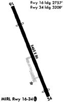
| A81-APT | ACTVT REILS RWY 16 & 34; PAPI RWY 16 & 34; MIRL RWY 16/34 - CTAF. |
Runways
Runway Summary
| Runways: | 16/34 |
| Longest Runway: | 16/34 is 5498 ft (1676 m) long |
| Runways with an Instrument Approach: | 34 |
KAFP Airport Runway Details
| Runway 16/34 | 5498 ft x 100 ft (1676 m x 30 m) | |
| Runway Length Source: | 3RD PARTY SURVEY as of 09/29/2021 | |
| Surface: | Asphalt - Excellent condition - No special surface treatment | |
| Runway Edge Lights: | Medium Intensity | |
Runway Weight Bearing Capacity (in thousands of pounds) |
||
| Single Wheel Landing Gear: | 12.0 | |
| Dual Wheel Landing Gear: | 60.0 | |
Runway 16 |
Runway 34 |
|
Elevation: |
299.3 | 296.8 |
Latitude: |
35-01-38.8451N | 35-00-49.7465N |
Longitude: |
080-04-51.8336W | 080-04-23.4144W |
|
Runway True Alignment: |
155 | 335 |
ILS Type: |
ILS/DME | |
Glide Path Angle: |
3.0 degrees | 3.0 degrees |
Traffic Pattern: |
Left | Left |
Runway Markings Type: |
Nonprecision Instrument | Precision Instrument |
Runway Markings Condition: |
Good | Good |
Object at End: |
TREES | TREES |
Object Height: |
83 | 23 |
Distance from End: |
1426 | 579 |
Object Centerline Offset: |
221 ft. right of centerline | 356 ft. right of centerline |
Visual Glide Slope Indicators: |
4-Light PAPI On Left Side Of Runway | 4-Light PAPI On Left Side Of Runway |
REIL: |
Yes | Yes |
Touchdown Lights: |
No | No |
Centerline Lights: |
No | No |
Threshold Crossing Height: |
44 | 45 |
Services
Airframe Repair: |
Minor |
Powerplant Repair: |
Minor |
Bottled Oxygen: |
None |
Bulk Oxygen: |
None |
Fuel Available: |
100LL |
Landing Fees: |
No |
Parking: |
Tiedowns available |
Maps & Diagrams
KAFP Sectional
Flight Planning
at skyvector.com
at skyvector.com