Location
Latitude: |
42-24-55.3000N (42.415361) |
Longitude: |
124-25-29.7000W (-124.424917) |
Elevation: |
20.5 feet MSL (6 m MSL) |
Magnetic Variation: |
14.4 E (as of May 2024 from WMM2020 model) |
Time Zone: |
UTC -8.0 (Standard Time) UTC -7.0 (Daylight Savings Time) |
From City: |
00 N.M. W of Gold Beach, Oregon |
Found On: |
Klamath Falls Chart |
FAA Region: |
ANM |
Contacts
Manager: |
Publicly owned: |
| ANDY WRIGHT BOX 1126 GOLD BEACH, OR 97444 (541) 373-7840 |
PORT OF GOLD BEACH BOX 1126 GOLD BEACH, OR 97444 541-247-6269 |
Operations
Airport Status: |
Operational |
Facility Use: |
Public |
Type: |
Airport |
Activation Date: |
04/1947 |
Control tower: |
No |
Attendance (Months/Days/Hours): |
Months/Days/Hours ALL/ALL/0800-1700 |
Boundary ARTCC: |
ZSE (Seattle) |
Responsible ARTCC: |
ZSE (Seattle) |
Lighting Schedule: |
SEE RMK |
Segmented Circle Indicator: |
Yes |
Traffic Pattern Altitude (MSL): |
1020 feet (311 m) |
NOTAMs Facility: |
MMV |
NOTAM-D Service: |
Yes |
International Airport of Entry: |
No |
Customs Landing Rights: |
No |
Military Landing Rights: |
Yes |
Civil/Military Joint Use: |
No |
Based Aircraft
| Single Engine: | 10 |
Annual Operations (as of 01/14/2019)
| Total Operations: | 5550 | |
| Air Taxi: | 800 | 14.4% |
| GA Local: | 1500 | 27.0% |
| GA Itinerant: | 3100 | 55.9% |
| Military Aircraft: | 150 | 2.7% |
Communications
| CTAF: | 122.800 |
| Unicom: | 122.800 |
| AWOS-3: | 118.15 (541-247-2518) |
- APCH/DEP CTL SVC PRVDD BY SEATTLE ARTCC (ZSE) ON 127.55/254.35 (HORTON RCAG ).
Fixed Based Operators (FBOs) & Fuel
(Click on a business for detail)
Please help us keep this information up to date. This is a FREE SERVICE just like everything else on Airport Guide! If you see that a business needs to be added, modified, or deleted please fill out our Update Form.
To add, modify, or delete a business click here.
Please help us keep this information up to date. This is a FREE SERVICE just like everything else on Airport Guide! If you see that a business needs to be added, modified, or deleted please fill out our Update Form.
Area Code: 541 |
| Business Name | Frequency | Phone | Fuel Grade |
|---|---|---|---|
| Airport Management
Update FBO info |
247-6269 | 100ll Jet A |
Flight Service Stations
| Primary | Alternate | |
| FSS on Field: | N | |
| FSS Name (ID): | Mc Minnville(MMV) | |
| Frequency: | ||
| Toll Free Phone: | 1-800-WX-BRIEF |
Instrument Procedures / Charts
FAA Terminal Procedures valid from 0901Z 03/21/24 to 0901Z 04/18/24.
There are various types of charts available for an airport. They are listed in the Page Type column. Here is a legend for those types:
APD - Airport Diagram
DP - Departure Procedure Charts
HOT - Hot Spots
IAP - Instrument Approach Procedure Charts
MIN - Minimums
STAR - Standard Terminal Arrival Charts
| Page Type | Page Name | Volume | Action Since Last Cycle |
|---|---|---|---|
| IAP | RNAV (GPS)-A | NW-1 | Changed |
| MIN | ALTERNATE MINIMUMS | NW-1 | |
| MIN | TAKEOFF MINIMUMS | NW-1 | |
| ODP | NELLL ONE (OBSTACLE) (RNAV) | NW-1 | |
| ODP | NELLL ONE (OBSTACLE) (RNAV)[DELIMITER] CONT.1 | NW-1 |
Terminal Procedures are only available for airports in several countries with more being added all the time. If you are looking for a specific country's charts, please send an email to support(at)airportguide.com stating the country name. This will be used to prioritize the implementation.
Navigation Aids (Navaids) near GOL
| Dist (NM) | ID | Morse Code | Name | Type | Freq | True Hdg | Mag Hdg |
|---|---|---|---|---|---|---|---|
| 39.0 | CEC | _ . _ . . _ . _ . | Crescent City | VORTAC | 109.00 | 167 | 153 |
| 59.0 | OT | _ _ _ _ | Emire | NDB | 378 | 4 | 350 |
| 61.1 | OTH | _ _ _ _ . . . . | North Bend | VOR-DME | 112.10 | 10 | 356 |
| 65.9 | RBG | . _ . _ . . . _ _ . | Roseburg | VOR-DME | 108.20 | 45 | 31 |
| 67.1 | OED | _ _ _ . _ . . | Rogue Valley | VORTAC | 113.60 | 86 | 72 |
| 68.0 | RBG | . _ . _ . . . _ _ . | Roseburg | NDB | 400 | 43 | 29 |
| 68.5 | MEF | _ _ . . . _ . | Medford | NDB | 356 | 90 | 76 |
| 69.2 | MFR | _ _ . . _ . . _ . | Medford | VOT | 117.20 | 92 | 78 |
| 87.2 | ACV | . _ _ . _ . . . . _ | Arcata | VOR-DME | 115.05 | 170 | 156 |
| 92.6 | FJS | . . _ . . _ _ _ . . . | Fort Jones | VOR-DME | 116.25 | 128 | 114 |
| 95.9 | MOG | _ _ _ _ _ _ _ . | Montague | NDB | 404 | 114 | 100 |
Nearby Airports with Fuel
Notices to Airmen (NOTAMS)
Remarks
| A110-1 | BE ALERT: BIRDS ON AND INVOF ARPT. |
| A110-2 | FOR CD CTC SEATTLE ARTCC AT 253-351-3694. |
| A43-16 | UNUSBL BYD 1 DEG LEFT OF CNTRLN. |
| A57-16 | APCH RATIO 20:1 TO DSPLCD THLD; TREES AT 4300 FT APCH RATIO 20:1. |
| A81-APT | ACTVT REIL RWY 16 & 34; PAPI 16; MIRL RWY 16/34 - CTAF. |
| A82 | UNICOM UNMON. |
Runways
Runway Summary
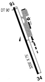
| Runways: | 16/34 |
| Longest Runway: | 16/34 is 3200 ft (975 m) long |
| Runways with an Instrument Approach: |
GOL Airport Runway Details
| Runway 16/34 | 3200 ft x 75 ft (975 m x 23 m) | |
| Runway Length Source: | 3RD PARTY SURVEY as of 07/28/2015 | |
| Surface: | Asphalt - Good condition - No special surface treatment | |
| Runway Edge Lights: | Medium Intensity | |
Runway Weight Bearing Capacity (in thousands of pounds) |
||
| Single Wheel Landing Gear: | 12.5 | |
Runway 16 |
Runway 34 |
|
Elevation: |
20.2 | 20.0 |
Latitude: |
42-25-11.0179N | 42-24-39.5174N |
Longitude: |
124-25-31.4599W | 124-25-27.9728W |
|
Runway True Alignment: |
175 | 355 |
Glide Path Angle: |
4.0 degrees | 0.0 degrees |
Traffic Pattern: |
Right | Left |
Runway Markings Type: |
Basic | Basic |
Runway Markings Condition: |
Good | Good |
Object at End: |
ROAD | ROAD |
Object Height: |
15 | 10 |
Distance from End: |
220 | 300 |
Object Centerline Offset: |
125 ft. left and right of centerline | 0 ft. left and right of centerline |
Visual Glide Slope Indicators: |
2-Light PAPI On Right Side Of Runway | |
REIL: |
Yes | Yes |
Threshold Crossing Height: |
48 | |
Threshold Elevation: |
20.3 | |
Displaced Threshold: |
90 | |
Threshold Latitude: |
42-25-10.1363N | |
Threshold Longitude: |
124-25-31.3631W |
Services
Airframe Repair: |
Major |
Powerplant Repair: |
Major |
Bottled Oxygen: |
None |
Bulk Oxygen: |
None |
Fuel Available: |
100LL |
Landing Fees: |
No |
Parking: |
Tiedowns available |
Maps & Diagrams
GOL Sectional
Flight Planning
at skyvector.com
at skyvector.com