Location
Latitude: |
34-13-32.4000N (34.225667) |
Longitude: |
099-17-01.5000W (-99.28375) |
Elevation: |
1264.7 feet MSL (385 m MSL) |
Magnetic Variation: |
4.2 E (as of April 2024 from WMM2020 model) |
Time Zone: |
UTC -6.0 (Standard Time) UTC -5.0 (Daylight Savings Time) |
From City: |
04 N.M. N of Vernon, Texas |
Found On: |
Dallas-Ft Worth Chart |
FAA Region: |
ASW |
Contacts
Manager: |
Publicly owned: |
| KYLE MILLER 12557 HAMP NAYLOR DRIVE VERNON, TX 76384 940-552-2182 |
WILBARGER COUNTY COUNTY COURTHOUSE, 1700 WILBARGER ST VERNON, TX 76384 940-553-2300 |
Operations
Airport Status: |
Operational |
Facility Use: |
Public |
Type: |
Airport |
Activation Date: |
02/1947 |
Control tower: |
No |
Attendance (Months/Days/Hours): |
Months/Days/Hours ALL/MON-SAT/0800-1700 |
Boundary ARTCC: |
ZFW (Fort Worth) |
Responsible ARTCC: |
ZFW (Fort Worth) |
Lighting Schedule: |
SEE RMK |
Segmented Circle Indicator: |
Yes |
Traffic Pattern Altitude (MSL): |
2265 feet (690 m) |
NOTAMs Facility: |
F05 |
NOTAM-D Service: |
Yes |
International Airport of Entry: |
No |
Customs Landing Rights: |
No |
Military Landing Rights: |
Yes |
Civil/Military Joint Use: |
No |
Based Aircraft
| Single Engine: | 17 |
| Multi Engine: | 1 |
| GA Helicopters: | 1 |
Annual Operations (as of 11/16/2023)
| Total Operations: | 5850 | |
| GA Local: | 4500 | 76.9% |
| GA Itinerant: | 1250 | 21.4% |
| Military Aircraft: | 100 | 1.7% |
Communications
| CTAF: | 122.800 |
| Unicom: | 122.800 |
| Approach: | ALTUS 125.1 125.1 125.1 FORT WORTH ARTCC |
| Departure: | ALTUS 125.1 125.1 125.1 FORT WORTH ARTCC |
| AWOS-3: | 118.525 (940-552-8600) |
- APCH/DEP CTL SVC PRVDD BY FORT WORTH ARTCC (ZFW) ON FREQS 128.4/269.375 (CLINTON-SHERMAN RCAG) & 133.5/350.35 (WICHITA FALLS NR 2 RCAG) WHEN ALTUS APCH CTL (LTS) CLSD.
Fixed Based Operators (FBOs) & Fuel
(Click on a business for detail)
Please help us keep this information up to date. This is a FREE SERVICE just like everything else on Airport Guide! If you see that a business needs to be added, modified, or deleted please fill out our Update Form.
To add, modify, or delete a business click here.
Please help us keep this information up to date. This is a FREE SERVICE just like everything else on Airport Guide! If you see that a business needs to be added, modified, or deleted please fill out our Update Form.
Area Code: 940 |
| Business Name | Frequency | Phone | Fuel Grade |
|---|---|---|---|
| Wilbarger County Airport
Update FBO info |
Unicom 122.8 | 552-2182 | 100LL, Jet A |
Flight Service Stations
| Primary | Alternate | |
| FSS on Field: | N | |
| FSS Name (ID): | Fort Worth(FTW) | |
| Frequency: | ||
| Toll Free Phone: | 1-800-WX-BRIEF |
Instrument Procedures / Charts
FAA Terminal Procedures valid from 0901Z 03/21/24 to 0901Z 04/18/24.
There are various types of charts available for an airport. They are listed in the Page Type column. Here is a legend for those types:
APD - Airport Diagram
DP - Departure Procedure Charts
HOT - Hot Spots
IAP - Instrument Approach Procedure Charts
MIN - Minimums
STAR - Standard Terminal Arrival Charts
| Page Type | Page Name | Volume | Action Since Last Cycle |
|---|---|---|---|
| IAP | RNAV (GPS) RWY 02 | SC-2 | |
| IAP | RNAV (GPS) RWY 20 | SC-2 | |
| MIN | ALTERNATE MINIMUMS | SC-2 | |
| MIN | TAKEOFF MINIMUMS | SC-2 |
Terminal Procedures are only available for airports in several countries with more being added all the time. If you are looking for a specific country's charts, please send an email to support(at)airportguide.com stating the country name. This will be used to prioritize the implementation.
Navigation Aids (Navaids) near WIB
| Dist (NM) | ID | Morse Code | Name | Type | Freq | True Hdg | Mag Hdg |
|---|---|---|---|---|---|---|---|
| 26.2 | LTS | . _ . . _ . . . | Altus | VORTAC | 109.80 | 1 | 357 |
| 37.2 | SPS | . . . . _ _ . . . . | Wichita Falls | VORTAC | 112.70 | 112 | 108 |
| 40.0 | HBR | . . . . _ . . . . _ . | Hobart | VORTAC | 111.80 | 15 | 11 |
| 42.1 | SHP | . . . . . . . . _ _ . | Sheppard | TACAN | 110.80 | 110 | 106 |
| 45.3 | ICF | . . _ . _ . . . _ . | Madison | NDB | 296 | 114 | 110 |
| 46.1 | LAW | . _ . . . _ . _ _ | Lawton | VOR-DME | 116.85 | 69 | 65 |
| 47.7 | SKB | . . . _ . _ _ . . . | Scotland | NDB | 344 | 123 | 119 |
| 49.2 | PFL | . _ _ . . . _ . . _ . . | Post | NDB | 425 | 61 | 57 |
| 50.6 | CDS | _ . _ . _ . . . . . | Childress | VORTAC | 117.00 | 280 | 276 |
| 54.9 | FSI | . . _ . . . . . . | Trail | FAN MARKER | 52 | 48 | |
| 54.9 | OFZ | _ _ _ . . _ . _ _ . . | Trail | NDB | 388 | 52 | 48 |
| 58.8 | GTH | _ _ . _ . . . . | Guthrie | DME | 114.5 | 243 | 239 |
| 60.8 | BFV | _ . . . . . _ . . . . _ | Burns Flat | VORTAC | 110.00 | 3 | 359 |
| 65.8 | AKL | . _ _ . _ . _ . . | Haskell | NDB | 407 | 199 | 195 |
| 68.4 | DUC | _ . . . . _ _ . _ . | Duncan | DME | 111 | 81 | 77 |
| 69.4 | SYO | . . . _ . _ _ _ _ _ | Sayre | VORTAC | 115.20 | 345 | 341 |
| 73.6 | BZ | _ . . . _ _ . . | Fossi | NDB | 393 | 3 | 359 |
| 74.7 | GHX | _ _ . . . . . _ . . _ | Graham | NDB | 371 | 148 | 144 |
| 83.8 | UKW | . . _ _ . _ . _ _ | Bowie | VORTAC | 117.15 | 119 | 115 |
| 83.9 | GMZ | _ _ . _ _ _ _ . . | Grindstone Mountain | NDB | 356 | 115 | 111 |
Nearby Airports with Fuel
Notices to Airmen (NOTAMS)
Remarks
| A110*G | THIS AIRPORT HAS BEEN SURVEYED BY THE NATIONAL GEODETIC SURVEY. |
| A110-1 | SEASONAL EXTSV AERIAL AG OPS. |
| A110-2 | FOR CD CTC FORT WORTH ARTCC AT 817-858-7584. |
| A110-3 | RWY 2/20 GRASS ENCROACHING 13 FT EACH SIDE |
| A70-FUEL-10 | 0LL 100 LL SELF-SERVE. 100LL, JET A+ FULL SERVE; AFT HRS SVC CALL 940-839-6365. |
| A81-APT | MIRLS DUSK-DAWN. |
| E111 | PRE-DATES ACT. |
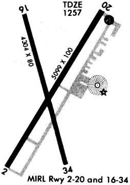
Runways
Runway Summary
| Runways: | 02/20 16/34 |
| Longest Runway: | 02/20 is 5099 ft (1554 m) long |
| Runways with an Instrument Approach: |
WIB Airport Runway Details
| Runway 02/20 | 5099 ft x 100 ft (1554 m x 30 m) | |
| Runway Length Source: | NGS as of 05/18/2008 | |
| Surface: | Asphalt - Excellent condition - No special surface treatment | |
| Runway Edge Lights: | Medium Intensity | |
Runway Weight Bearing Capacity (in thousands of pounds) |
||
| Single Wheel Landing Gear: | 30.0 | |
| Dual Wheel Landing Gear: | 40.0 | |
| Dual Tandem Wheel Landing Gear: | 60.0 | |
Runway 02 |
Runway 20 |
|
Elevation: |
1264.4 | 1255.3 |
Latitude: |
34-13-11.3757N | 34-13-54.1977N |
Longitude: |
099-17-15.9995W | 099-16-43.9147W |
|
Runway True Alignment: |
032 | 212 |
Glide Path Angle: |
0.0 degrees | 3.0 degrees |
Traffic Pattern: |
Left | Left |
Runway Markings Type: |
Nonprecision Instrument | Nonprecision Instrument |
Runway Markings Condition: |
Good | Good |
Object at End: |
ROAD | ROAD |
Object Height: |
15 | 10 |
Distance from End: |
710 | 617 |
Object Centerline Offset: |
295 ft. right of centerline | 317 ft. left of centerline |
Visual Glide Slope Indicators: |
4-Box VASI On Left Side Of Runway | |
Threshold Crossing Height: |
25 |
| Runway 16/34 | 4304 ft x 80 ft (1312 m x 24 m) | |
| Runway Length Source: | NGS as of 05/18/2008 | |
| Surface: | Asphalt - Excellent condition - No special surface treatment | |
| Runway Edge Lights: | Medium Intensity | |
Runway Weight Bearing Capacity (in thousands of pounds) |
||
| Single Wheel Landing Gear: | 10.0 | |
Runway 16 |
Runway 34 |
|
Elevation: |
1258.3 | 1259.2 |
Latitude: |
34-13-52.6692N | 34-13-11.4078N |
Longitude: |
099-17-09.5406W | 099-16-56.9070W |
|
Runway True Alignment: |
166 | 346 |
Glide Path Angle: |
0.0 degrees | 0.0 degrees |
Traffic Pattern: |
Left | Left |
Runway Markings Type: |
Nonprecision Instrument | Nonprecision Instrument |
Runway Markings Condition: |
Good | Good |
Object at End: |
ROAD | |
Object Height: |
12 | |
Distance from End: |
432 | |
Object Centerline Offset: |
295 ft. right of centerline | 317 ft. left of centerline |
Services
Airframe Repair: |
Major |
Powerplant Repair: |
Major |
Bottled Oxygen: |
None |
Bulk Oxygen: |
None |
Fuel Available: |
100LL |
Landing Fees: |
No |
Parking: |
Hangars and tiedowns available |
Maps & Diagrams
WIB Sectional
Flight Planning
at skyvector.com
at skyvector.com