Location
Latitude: |
32-59-25.1040N (32.990307) |
Longitude: |
097-19-09.9460W (-97.319429) |
Elevation: |
723.2 feet MSL (220 m MSL) |
Magnetic Variation: |
3 E (as of April 2024 from WMM2020 model) |
Time Zone: |
UTC -6.0 (Standard Time) UTC -5.0 (Daylight Savings Time) |
From City: |
14 N.M. N of Fort Worth, Texas |
Found On: |
Dallas-Ft Worth Chart |
FAA Region: |
ASW |
Contacts
Manager: |
Publicly owned: |
| CHRISTIAN CHILDS 2221 ALLIANCE BLVD SUITE 100 FORT WORTH, TX 76177 817-890-1000 |
CITY OF FORT WORTH 1000 THROCKMORTON FORT WORTH, TX 76177 817-392-6116 |
Operations
Airport Status: |
Operational |
Facility Use: |
Public |
Type: |
Airport |
Activation Date: |
12/1989 |
Control tower: |
Yes |
Attendance (Months/Days/Hours): |
Months/Days/Hours ALL/ALL/ALL |
Boundary ARTCC: |
ZFW (Fort Worth) |
Responsible ARTCC: |
ZFW (Fort Worth) |
Lighting Schedule: |
SS-SR |
Segmented Circle Indicator: |
Yes |
Traffic Pattern Altitude (MSL): |
1723 feet (525 m) |
NOTAMs Facility: |
AFW |
NOTAM-D Service: |
Yes |
International Airport of Entry: |
No |
Customs Landing Rights: |
No |
Military Landing Rights: |
Yes |
Aircraft Rescue and Firefighting: |
Class IV ARFF Index: A Air Carrier Service: Not Scheduled Certification Date: 12/1989 |
Based Aircraft
| Single Engine: | 1 |
| Multi Engine: | 5 |
| Jet Engine: | 8 |
| GA Helicopters: | 8 |
Annual Operations (as of 03/31/2023)
| Total Operations: | 109652 | |
| Commercial: | 19957 | 18.2% |
| Air Taxi: | 12061 | 11.0% |
| GA Local: | 31637 | 28.9% |
| GA Itinerant: | 35008 | 31.9% |
| Military Aircraft: | 10989 | 10.0% |
Communications
| Tower: | ALLIANCE 120.825 ;HELICOPTERS 135.15 257.9 Hrs: 24 |
| Clearance Del.: | 128.725 |
| Ground: | 132.65 306.2 |
| Approach: | REGIONAL |
| Departure: | REGIONAL |
| ATIS: | 126.925 Hrs: 24 |
| ASOS: | (817-491-6188) |
- EMERGENCY FREQ NOT AVBL.
Fixed Based Operators (FBOs) & Fuel
(Click on a business for detail)
Please help us keep this information up to date. This is a FREE SERVICE just like everything else on Airport Guide! If you see that a business needs to be added, modified, or deleted please fill out our Update Form.
To add, modify, or delete a business click here.
Please help us keep this information up to date. This is a FREE SERVICE just like everything else on Airport Guide! If you see that a business needs to be added, modified, or deleted please fill out our Update Form.
Area Code: 817 |
| Business Name | Frequency | Phone | Fuel Grade |
|---|---|---|---|
| Alliance Air/Aviation Services
Update FBO info |
837-1000 | 100LL, Jet A |
Flight Service Stations
| Primary | Alternate | |
| FSS on Field: | N | |
| FSS Name (ID): | Fort Worth(FTW) | |
| Frequency: | ||
| Toll Free Phone: | 1-800-WX-BRIEF |
Instrument Procedures / Charts
FAA Terminal Procedures valid from 0901Z 03/21/24 to 0901Z 04/18/24.
There are various types of charts available for an airport. They are listed in the Page Type column. Here is a legend for those types:
APD - Airport Diagram
DP - Departure Procedure Charts
HOT - Hot Spots
IAP - Instrument Approach Procedure Charts
MIN - Minimums
STAR - Standard Terminal Arrival Charts
Terminal Procedures are only available for airports in several countries with more being added all the time. If you are looking for a specific country's charts, please send an email to support(at)airportguide.com stating the country name. This will be used to prioritize the implementation.
Navigation Aids (Navaids) near AFW
| Dist (NM) | ID | Morse Code | Name | Type | Freq | True Hdg | Mag Hdg |
|---|---|---|---|---|---|---|---|
| 6.4 | FT | . . _ . _ | Mufin | NDB | 365 | 204 | 201 |
| 9.3 | FUZ | . . _ . . . _ _ _ . . | Ranger | VORTAC | 115.70 | 130 | 127 |
| 10.5 | FTW | . . _ . _ . _ _ | Fort Worth | VOT | 108.20 | 192 | 189 |
| 14.5 | NFW | _ . . . _ . . _ _ | Nas Jrb Fort Worth | TACAN | 108.70 | 204 | 201 |
| 15.8 | TTT | _ _ _ | Maverick | VOR-DME | 113.10 | 117 | 114 |
| 18.6 | DT | _ . . _ | Pinck | NDB | 257 | 19 | 16 |
| 21.8 | CVE | _ . _ . . . . _ . | Cowboy | VOR-DME | 116.20 | 105 | 102 |
| 25.1 | DAL | _ . . . _ . _ . . | Dallas | VOT | 113.30 | 108 | 105 |
| 37.7 | MQP | _ _ _ _ . _ . _ _ . | Millsap | VORTAC | 117.70 | 245 | 242 |
| 40.2 | VLY | . . . _ . _ . . _ . _ _ | Melisa | NDB | 421 | 65 | 62 |
| 41.3 | PQF | . _ _ . _ _ . _ . . _ . | Mesquite | NDB | 248 | 105 | 102 |
| 41.3 | UKW | . . _ _ . _ . _ _ | Bowie | VORTAC | 117.15 | 322 | 319 |
| 43.4 | GMZ | _ _ . _ _ _ _ . . | Grindstone Mountain | NDB | 356 | 328 | 325 |
| 44.1 | JUG | . _ _ _ . . _ _ _ . | Jecca | NDB | 388 | 115 | 112 |
| 54.0 | MII | _ _ . . . . | Caddo Mills | NDB | 316 | 86 | 83 |
| 55.7 | AVZ | . _ . . . _ _ _ . . | Travis | NDB | 260 | 104 | 101 |
| 57.3 | JEN | . _ _ _ . _ . | Glen Rose | TACAN | 115.00 | 209 | 206 |
| 59.8 | DNI | _ . . _ . . . | Denison | NDB | 341 | 32 | 29 |
| 60.1 | GHX | _ _ . . . . . _ . . _ | Graham | NDB | 371 | 280 | 277 |
| 63.0 | SYW | . . . _ . _ _ . _ _ | Cash | NDB | 428 | 90 | 87 |
Nearby Airports with Fuel
Notices to Airmen (NOTAMS)
Remarks
| A110-3 | FLIGHT NOTIFICATION SERVICE (ADCUS) AVBL. |
| A110-4 | PORTIONS OF TWY H MOVEMENT AREA EAST OF TWY A IS NOT VISIBLE FROM ATCT. |
| A26 | ARFF INDEX E AVAILABLE. PPR FOR ACR OPNS WITH MORE THAN 30 PSGR SEATS CALL 817-890-1000 OR 800-318-9268. |
| A57-16R | APCH RATIO 0:1 BASED ON DSPLCD THLD; +5 FT FENCE 0 FT, 250 FT R. |
| A57-34L | APCH RATIO 50:1 TO DSPLCD THLD. |
| A58-34L | +4 FT FENCE 0 FT 250 FT L; APCH RATIO 0:1 BASED ON DSPLCD THLD. |
| A71 | PRIOR ARRANGEMENTS REQUIRED FOR AIRFRAME OR POWER PLANT REPAIRS FOR DESIGN GROUP III & ABOVE. |
| A82 | ARINC FREQ 129.75 AVBL. |
| E111 | PRVDD CONDITIONS CONTAINED IN 08/01/89 LTR TO MR. DAVID IVORY ARE ADHERED TO. |
| E80 | US CUSTOMS USER FEE ARPT. |
Runways
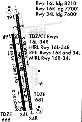
Runway Summary
| Runways: | 16L/34R 16R/34L |
| Longest Runway: | 16R/34L is 11125 ft (3391 m) long |
| Runways with an Instrument Approach: | 16L, 34R |
AFW Airport Runway Details
| Runway 16L/34R | 11000 ft x 150 ft (3353 m x 46 m) | |
| Runway Length Source: | 3RD PARTY SURVEY as of 09/01/2022 | |
| Surface: | Concrete - Good condition - Saw-cut or plastic grooved | |
| Runway Pavement Class: | 82 /R/B/W/T | |
| Runway Edge Lights: | High Intensity | |
Runway Weight Bearing Capacity (in thousands of pounds) |
||
| Dual Wheel Landing Gear: | 200.0 | |
| Dual Tandem Wheel Landing Gear: | 400.0 | |
| Dual Dual Tandem Wheel Landing Gear: | 870.0 | |
Runway 16L |
Runway 34R |
|
Elevation: |
723.1 | 664.2 |
Latitude: |
33-00-19.5411N | 32-58-32.2949N |
Longitude: |
097-19-17.4945W | 097-18-55.5436W |
|
Runway True Alignment: |
170 | 350 |
ILS Type: |
ILS/DME | ILS/DME |
Glide Path Angle: |
0.0 degrees | 0.0 degrees |
Traffic Pattern: |
Right | Left |
Runway Markings Type: |
Precision Instrument | Precision Instrument |
Runway Markings Condition: |
Good | Good |
Object at End: |
PLINE | |
Object Height: |
182 | |
Object Marked/Lighted?: |
Lighted | |
Distance from End: |
7920 | |
Object Centerline Offset: |
590 ft. right of centerline | |
Runway Visual Range (RVR): |
Touchdown, Midfield, Rollout | Touchdown, Midfield, Rollout |
Approach Light System: |
Standard 2,400 Foot High Intensity Approach Lighting System With Sequenced Flashers, Cat. II or III Config. | 1,400 Foot Medium Intensity Approach Lighting System With Runway Alignment Indicator Lights |
Touchdown Lights: |
Yes | Yes |
Centerline Lights: |
Yes | Yes |
Declared Distances |
||
Take Off Run Avbl. (TORA): |
10600 | 11000 |
Take Off Distance Avbl. (TODA): |
10600 | 11000 |
Actual Stop Dist. Avbl. (ASDA): |
10600 | 11000 |
Landing Dist. Avbl. (LDA): |
10600 | 11000 |
| Runway 16R/34L | 11125 ft x 150 ft (3391 m x 46 m) | |
| Runway Length Source: | 3RD PARTY SURVEY as of 09/01/2022 | |
| Surface: | Concrete - Good condition - Saw-cut or plastic grooved | |
| Runway Pavement Class: | 82 /R/B/W/T | |
| Runway Edge Lights: | High Intensity | |
Runway Weight Bearing Capacity (in thousands of pounds) |
||
| Dual Wheel Landing Gear: | 200.0 | |
| Dual Tandem Wheel Landing Gear: | 400.0 | |
| Dual Dual Tandem Wheel Landing Gear: | 870.0 | |
Runway 16R |
Runway 34L |
|
Elevation: |
721.2 | 664.7 |
Latitude: |
33-00-18.5327N | 32-58-30.0666N |
Longitude: |
097-19-24.4396W | 097-19-02.2369W |
|
Runway True Alignment: |
170 | 350 |
Glide Path Angle: |
3.0 degrees | 3.0 degrees |
Traffic Pattern: |
Right | Left |
Runway Markings Type: |
Precision Instrument | Precision Instrument |
Runway Markings Condition: |
Good | Good |
Object at End: |
RR | FENCE |
Object Height: |
19 | 4 |
Distance from End: |
607 | 200 |
Object Centerline Offset: |
590 ft. right of centerline | |
Visual Glide Slope Indicators: |
4-Light PAPI On Right Side Of Runway | 4-Light PAPI On Left Side Of Runway |
REIL: |
Yes | Yes |
Threshold Crossing Height: |
82 | 74 |
Threshold Elevation: |
668.3 | |
Displaced Threshold: |
716 | |
Threshold Latitude: |
32-58-37.0522N | |
Threshold Longitude: |
097-19-03.6660W | |
Declared Distances |
||
Take Off Run Avbl. (TORA): |
11010 | 11010 |
Take Off Distance Avbl. (TODA): |
11010 | 11010 |
Actual Stop Dist. Avbl. (ASDA): |
10410 | 11010 |
Landing Dist. Avbl. (LDA): |
10410 | 10409 |
Services
Airframe Repair: |
Major |
Powerplant Repair: |
Major |
Bottled Oxygen: |
None |
Bulk Oxygen: |
None |
Fuel Available: |
100LL, Jet A+ |
Landing Fees: |
No |
Parking: |
Tiedowns available |
Maps & Diagrams
AFW Sectional
Flight Planning
at skyvector.com
at skyvector.com