Location
Latitude: |
41-19-38.0000N (41.327222) |
Longitude: |
094-26-42.6000W (-94.445167) |
Elevation: |
1363.6 feet MSL (416 m MSL) |
Magnetic Variation: |
1 E (as of May 2024 from WMM2020 model) |
Time Zone: |
UTC -6.0 (Standard Time) UTC -5.0 (Daylight Savings Time) |
From City: |
02 N.M. NE of Greenfield, Iowa |
Found On: |
Omaha Chart |
FAA Region: |
ACE |
Contacts
Manager: |
Publicly owned: |
| BRIAN HOADLEY 202 SOUTH 1ST STREET GREENFIELD, IA 50849 641-743-6384 |
CITY OF GREENFIELD 202 SOUTH 1ST STREET GREENFIELD, IA 50849 641-743-2183 |
Operations
Airport Status: |
Operational |
Facility Use: |
Public |
Type: |
Airport |
Activation Date: |
02/1958 |
Control tower: |
No |
Attendance (Months/Days/Hours): |
Months/Days/Hours Unattended |
Boundary ARTCC: |
ZMP (Minneapolis) |
Responsible ARTCC: |
ZMP (Minneapolis) |
Lighting Schedule: |
SEE RMK |
Segmented Circle Indicator: |
No |
Traffic Pattern Altitude (MSL): |
2364 feet (721 m) |
NOTAMs Facility: |
FOD |
NOTAM-D Service: |
Yes |
International Airport of Entry: |
No |
Customs Landing Rights: |
No |
Military Landing Rights: |
Yes |
Civil/Military Joint Use: |
No |
Based Aircraft
| Single Engine: | 24 |
| Multi Engine: | 2 |
| Gliders: | 1 |
Annual Operations (as of 06/02/2020)
| Total Operations: | 6500 | |
| GA Local: | 2807 | 43.2% |
| GA Itinerant: | 3693 | 56.8% |
Communications
| CTAF: | 122.900 |
- APCH/DEP SVC PRVDD BY MINNEAPOLIS ARTCC ON FREQS 125.65/306.950 (DES MOINES RCAG).
Fixed Based Operators (FBOs) & Fuel
(Click on a business for detail)
Please help us keep this information up to date. This is a FREE SERVICE just like everything else on Airport Guide! If you see that a business needs to be added, modified, or deleted please fill out our Update Form.
To add, modify, or delete a business click here.
Please help us keep this information up to date. This is a FREE SERVICE just like everything else on Airport Guide! If you see that a business needs to be added, modified, or deleted please fill out our Update Form.
Area Code: 641 |
| Business Name | Frequency | Phone | Fuel Grade |
|---|---|---|---|
| Iowa Aviation Preservation Center
Update FBO info |
343-7184 | 100LL |
Flight Service Stations
| Primary | Alternate | |
| FSS on Field: | N | |
| FSS Name (ID): | Fort Dodge(FOD) | |
| Frequency: | ||
| Toll Free Phone: | 1-800-WX-BRIEF |
Instrument Procedures / Charts
FAA Terminal Procedures valid from 0901Z 03/21/24 to 0901Z 04/18/24.
There are various types of charts available for an airport. They are listed in the Page Type column. Here is a legend for those types:
APD - Airport Diagram
DP - Departure Procedure Charts
HOT - Hot Spots
IAP - Instrument Approach Procedure Charts
MIN - Minimums
STAR - Standard Terminal Arrival Charts
| Page Type | Page Name | Volume | Action Since Last Cycle |
|---|---|---|---|
| IAP | RNAV (GPS) RWY 07 | NC-3 | |
| IAP | RNAV (GPS) RWY 25 | NC-3 | |
| MIN | TAKEOFF MINIMUMS | NC-3 |
Terminal Procedures are only available for airports in several countries with more being added all the time. If you are looking for a specific country's charts, please send an email to support(at)airportguide.com stating the country name. This will be used to prioritize the implementation.
Navigation Aids (Navaids) near KGFZ
| Dist (NM) | ID | Morse Code | Name | Type | Freq | True Hdg | Mag Hdg |
|---|---|---|---|---|---|---|---|
| 22.6 | UNE | . . _ _ . . | Union County | NDB | 379 | 168 | 167 |
| 24.3 | CRZ | _ . _ . . _ . _ _ . . | Corning | NDB | 278 | 215 | 214 |
| 27.5 | AIO | . _ . . _ _ _ | Atlantic | NDB | 365 | 279 | 278 |
| 30.1 | ADU | . _ _ . . . . _ | Audubon | NDB | 266 | 316 | 315 |
| 36.5 | DSM | _ . . . . . _ _ | Des Moines | VORTAC | 117.50 | 79 | 78 |
| 37.6 | DSM | _ . . . . . _ _ | Des Moines | VOT | 109.20 | 70 | 69 |
| 41.1 | RDK | . _ . _ . . _ . _ | Red Oak | NDB | 230 | 243 | 242 |
| 41.4 | EFW | . . . _ . . _ _ | Jefferson | NDB | 391 | 6 | 5 |
| 43.0 | HNR | . . . . _ . . _ . | Harlan | NDB | 272 | 290 | 289 |
| 44.8 | ICL | . . _ . _ . . _ . . | Clarinda | NDB | 353 | 216 | 215 |
| 48.9 | LMN | . _ . . _ _ _ . | Lamoni | VOR-DME | 116.70 | 153 | 152 |
| 49.4 | EE | . . | Merle | NDB | 362 | 45 | 44 |
| 55.6 | SDA | . . . _ . . . _ | Shenandoah | NDB | 411 | 231 | 230 |
| 57.5 | DNS | _ . . _ . . . . | Denison | NDB | 350 | 313 | 312 |
| 59.1 | OVR | _ _ _ . . . _ . _ . | Omaha | VORTAC | 116.30 | 261 | 260 |
| 62.2 | EN | . _ . | Rikky | NDB | 426 | 264 | 263 |
| 65.0 | OMA | _ _ _ _ _ . _ | Omaha | VOT | 109.00 | 268 | 266 |
| 66.0 | TNU | _ _ . . . _ | Newton | VOR-DME | 112.50 | 65 | 65 |
| 66.9 | OFF | _ _ _ . . _ . . . _ . | Offutt | TACAN | 111.70 | 259 | 257 |
| 67.6 | SKI | . . . _ . _ . . | Sac City | NDB | 356 | 339 | 338 |
Nearby Airports with Fuel
Notices to Airmen (NOTAMS)
Remarks
| A110-1 | PHONE ON ARPT. |
| A110-2 | INADQT CLNC FOR HLDG ON TURNAROUND AT THLD OF RWY 14. |
| A110-3 | RY 25 IS CALM WIND RY. |
| A110-4 | FOR CD CTC MINNEAPOLIS ARTCC AT 651-463-5588. |
| A58-32 | 18' HANGAR 50' FROM RWY END AND 250' RIGHT |
| A81-APT | ACTVT MIRL RY 7/25 - CTAF. MIRL RY 07/25 PRESET ON LOW INTST; TO INCR INTST - CTAF. |
| A83 | WIND INDICATOR LIGHTS ACTIVATED VIA 122.9. |
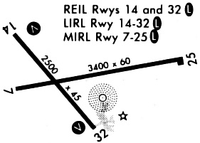
Runways
Runway Summary
| Runways: | 07/25 14/32 |
| Longest Runway: | 07/25 is 3400 ft (1036 m) long |
| Runways with an Instrument Approach: |
KGFZ Airport Runway Details
| Runway 07/25 | 3400 ft x 60 ft (1036 m x 18 m) | |
| Runway Length Source: | 3RD PARTY SURVEY as of 11/09/2008 | |
| Surface: | Concrete - Good condition - No special surface treatment | |
| Runway Pavement Class: | 6 /R/D/W/U | |
| Runway Edge Lights: | Medium Intensity | |
Runway 07 |
Runway 25 |
|
Elevation: |
1359.1 | 1363.6 |
Latitude: |
41-19-35.4477N | 41-19-41.8761N |
Longitude: |
094-26-57.5192W | 094-26-13.7817W |
|
Runway True Alignment: |
078 | 258 |
Glide Path Angle: |
0.0 degrees | 0.0 degrees |
Runway Markings Type: |
Nonprecision Instrument | Nonprecision Instrument |
Runway Markings Condition: |
Good | Good |
| Runway 14/32 | 2500 ft x 50 ft (762 m x 15 m) | |
| Runway Length Source: | 3RD PARTY SURVEY as of 11/09/2008 | |
| Surface: | Concrete - Good condition - No special surface treatment | |
| Runway Pavement Class: | 6 /R/D/W/U | |
Runway Weight Bearing Capacity (in thousands of pounds) |
||
| Single Wheel Landing Gear: | 7.0 | |
Runway 14 |
Runway 32 |
|
Elevation: |
1356.6 | 1362.2 |
Latitude: |
41-19-46.8282N | 41-19-27.2770N |
Longitude: |
094-27-02.0728W | 094-26-42.0800W |
|
Runway True Alignment: |
142 | 322 |
Glide Path Angle: |
0.0 degrees | 0.0 degrees |
Traffic Pattern: |
Left | Left |
Runway Markings Type: |
Basic | Basic |
Runway Markings Condition: |
Good | Good |
Object at End: |
ROAD | |
Object Height: |
16 | |
Distance from End: |
320 | |
REIL: |
No | No |
Threshold Elevation: |
1361.4 | |
Displaced Threshold: |
250 | |
Threshold Latitude: |
41-19-29.2310N | |
Threshold Longitude: |
094-26-44.0760W | |
Declared Distances |
||
Take Off Run Avbl. (TORA): |
2250 | 2500 |
Take Off Distance Avbl. (TODA): |
2250 | 2500 |
Actual Stop Dist. Avbl. (ASDA): |
2500 | 2500 |
Landing Dist. Avbl. (LDA): |
2500 | 2250 |
Services
Airframe Repair: |
Major |
Powerplant Repair: |
Major |
Bottled Oxygen: |
None |
Bulk Oxygen: |
None |
Fuel Available: |
100LL, Jet A |
Landing Fees: |
No |
Parking: |
Hangars and tiedowns available |
Maps & Diagrams
KGFZ Sectional
Flight Planning
at skyvector.com
at skyvector.com