Location
Latitude: |
41-35-03.7000N (41.584361) |
Longitude: |
095-20-22.9000W (-95.339694) |
Elevation: |
1231.0 feet MSL (375 m MSL) |
Magnetic Variation: |
1.7 E (as of April 2024 from WMM2020 model) |
Time Zone: |
UTC -6.0 (Standard Time) UTC -5.0 (Daylight Savings Time) |
From City: |
03 N.M. SW of Harlan, Iowa |
Found On: |
Omaha Chart |
FAA Region: |
ACE |
Contacts
Manager: |
Publicly owned: |
| SCOTT PIGSLEY 610 HWY 59 HARLAN, IA 51537 712-744-3366 |
CITY OF HARLAN CITY HALL/BOX 650 HARLAN, IA 51537 712-755-5137 |
Operations
Airport Status: |
Operational |
Facility Use: |
Public |
Type: |
Airport |
Activation Date: |
12/1944 |
Control tower: |
No |
Attendance (Months/Days/Hours): |
Months/Days/Hours APR-SEP/MON-FRI/0800-1700 |
Boundary ARTCC: |
ZMP (Minneapolis) |
Responsible ARTCC: |
ZMP (Minneapolis) |
Lighting Schedule: |
SEE RMK |
Segmented Circle Indicator: |
No |
Traffic Pattern Altitude (MSL): |
2231 feet (680 m) |
NOTAMs Facility: |
HNR |
NOTAM-D Service: |
Yes |
International Airport of Entry: |
No |
Customs Landing Rights: |
No |
Military Landing Rights: |
Yes |
Civil/Military Joint Use: |
No |
Based Aircraft
| Single Engine: | 25 |
| Multi Engine: | 1 |
Annual Operations (as of 10/03/2018)
| Total Operations: | 6750 | |
| GA Local: | 2914 | 43.2% |
| GA Itinerant: | 3836 | 56.8% |
Communications
| CTAF: | 122.800 |
| Unicom: | 122.800 |
| Approach: | OMAHA 124.5 124.5 |
| Departure: | OMAHA 124.5 124.5 |
| AWOS-3: | 118.325 (712-744-4400) |
Fixed Based Operators (FBOs) & Fuel
(Click on a business for detail)
Please help us keep this information up to date. This is a FREE SERVICE just like everything else on Airport Guide! If you see that a business needs to be added, modified, or deleted please fill out our Update Form.
To add, modify, or delete a business click here.
Please help us keep this information up to date. This is a FREE SERVICE just like everything else on Airport Guide! If you see that a business needs to be added, modified, or deleted please fill out our Update Form.
Area Code: 712 |
| Business Name | Frequency | Phone | Fuel Grade |
|---|---|---|---|
| Harlan Flying Service
Update FBO info |
Unicom 122.8 | 744-3366 | 100LL, MOGAS |

|
Phillips | 100LL - 1.96 USD per gallon on 10/21/2021 |
Pumps requiring line service |
|
|
Phillips | Jet A - 2.00 USD per gallon on 8/29/01 |
Pumps requiring line service |
|
|
Phillips | MOGAS - 1.89 USD per gallon on 8/29/01 |
Pumps requiring line service |
Flight Service Stations
| Primary | Alternate | |
| FSS on Field: | N | |
| FSS Name (ID): | Fort Dodge(FOD) | |
| Frequency: | ||
| Toll Free Phone: | 1-800-WX-BRIEF |
Instrument Procedures / Charts
FAA Terminal Procedures valid from 0901Z 03/21/24 to 0901Z 04/18/24.
There are various types of charts available for an airport. They are listed in the Page Type column. Here is a legend for those types:
APD - Airport Diagram
DP - Departure Procedure Charts
HOT - Hot Spots
IAP - Instrument Approach Procedure Charts
MIN - Minimums
STAR - Standard Terminal Arrival Charts
| Page Type | Page Name | Volume | Action Since Last Cycle |
|---|---|---|---|
| IAP | GPS RWY 33 | NC-3 | |
| IAP | RNAV (GPS) RWY 15 | NC-3 | |
| MIN | TAKEOFF MINIMUMS | NC-3 |
Terminal Procedures are only available for airports in several countries with more being added all the time. If you are looking for a specific country's charts, please send an email to support(at)airportguide.com stating the country name. This will be used to prioritize the implementation.
Navigation Aids (Navaids) near KHNR
| Dist (NM) | ID | Morse Code | Name | Type | Freq | True Hdg | Mag Hdg |
|---|---|---|---|---|---|---|---|
| 0.3 | HNR | . . . . _ . . _ . | Harlan | NDB | 272 | 190 | 188 |
| 17.1 | AIO | . _ . . _ _ _ | Atlantic | NDB | 365 | 129 | 127 |
| 20.3 | ADU | . _ _ . . . . _ | Audubon | NDB | 266 | 71 | 69 |
| 24.0 | DNS | _ . . _ . . . . | Denison | NDB | 350 | 355 | 353 |
| 30.1 | OMA | _ _ _ _ _ . _ | Omaha | VOT | 109.00 | 235 | 233 |
| 30.6 | OM | _ _ _ _ _ | Gerfi | NDB | 320 | 244 | 242 |
| 30.7 | EN | . _ . | Rikky | NDB | 426 | 224 | 222 |
| 30.8 | OVR | _ _ _ . . . _ . _ . | Omaha | VORTAC | 116.30 | 215 | 213 |
| 34.4 | RDK | . _ . _ . . _ . _ | Red Oak | NDB | 230 | 173 | 171 |
| 37.7 | OFF | _ _ _ . . _ . . . _ . | Offutt | TACAN | 111.70 | 222 | 220 |
| 39.0 | TQE | _ _ _ . _ . | Tekamah | VOR | 108.40 | 285 | 283 |
| 41.1 | MEY | _ _ . _ . _ _ | Mapleton | NDB | 335 | 330 | 328 |
| 42.0 | MLE | _ _ . _ . . . | Millard | NDB | 371 | 236 | 234 |
| 44.0 | CRZ | _ . _ . . _ . _ _ . . | Corning | NDB | 278 | 143 | 142 |
| 46.3 | PMV | . _ _ . _ _ . . . _ | Plattsmouth | NDB | 329 | 214 | 212 |
| 50.1 | SDA | . . . _ . . . _ | Shenandoah | NDB | 411 | 183 | 181 |
| 50.4 | SKI | . . . _ . _ . . | Sac City | NDB | 356 | 18 | 16 |
| 51.5 | EFW | . . . _ . . _ _ | Jefferson | NDB | 391 | 59 | 58 |
| 53.5 | ICL | . . _ . _ . . _ . . | Clarinda | NDB | 353 | 164 | 162 |
| 57.9 | SCB | . . . _ . _ . _ . . . | Scribner | VOR-DME | 111.00 | 271 | 269 |
Nearby Airports with Fuel
Notices to Airmen (NOTAMS)
Remarks
| A110-3 | RY 15 IS CALM WIND RY. |
| A110-4 | FOR CD CTC OMAHA APCH AT 402-682-4395. |
| A110-5 | SCOTT MCLAUGHLIN, CHAIRMAN, ARPT COMMISSION |
| A110-6 | (CONTACT TITLE) DAN KLEINPASTE, CHAIRMAN, ARPT COMM. |
| A42-03 | RY 03/21 THLDS & SIDES MARKED WITH CONES. |
| A70-FUEL-10 | 0LL SELF SERVE OR FULL SVC ON REQ. |
| A70-FUEL-A | SELF SERVE OR FULL SVC ON REQ. |
| A81-APT | ACTVT REIL RWY 15 & 33; PAPI RWY 15 & 33; MIRL RWY 15/33 - CTAF. |
Runways
Runway Summary
| Runways: | 03/21 15/33 |
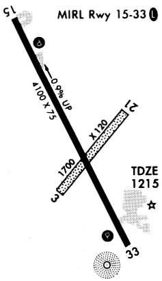
| Longest Runway: | 15/33 is 4100 ft (1250 m) long |
| Runways with an Instrument Approach: |
KHNR Airport Runway Details
| Runway 03/21 | 1712 ft x 120 ft (522 m x 37 m) | |
| Runway Length Source: | 3RD PARTY SURVEY as of 11/28/2011 | |
| Surface: | Turf - Fair condition - No special surface treatment | |
| Runway Pavement Class: | 7 /R/C/W/T | |
Runway 03 |
Runway 21 |
|
Elevation: |
1194.1 | 1193.8 |
Latitude: |
41-34-53.3106N | 41-35-06.3081N |
Longitude: |
095-20-28.2935W | 095-20-13.8717W |
|
Runway True Alignment: |
040 | 220 |
Glide Path Angle: |
0.0 degrees | 0.0 degrees |
Traffic Pattern: |
Left | Left |
Object at End: |
FENCE | FENCE |
Object Height: |
8 | 10 |
Distance from End: |
200 | 295 |
Object Centerline Offset: |
0 ft. left and right of centerline | 0 ft. left and right of centerline |
| Runway 15/33 | 4100 ft x 75 ft (1250 m x 23 m) | |
| Runway Length Source: | 3RD PARTY SURVEY as of 11/28/2011 | |
| Surface: | Turf - Fair condition - No special surface treatment | |
| Runway Edge Lights: | Medium Intensity | |
Runway Weight Bearing Capacity (in thousands of pounds) |
||
| Single Wheel Landing Gear: | 20.0 | |
| Dual Wheel Landing Gear: | 25.0 | |
Runway 15 |
Runway 33 |
|
Elevation: |
1231.0 | 1194.3 |
Latitude: |
41-35-23.6725N | 41-34-46.9168N |
Longitude: |
095-20-35.0073W | 095-20-12.3606W |
|
Runway True Alignment: |
155 | 335 |
Glide Path Angle: |
3.0 degrees | 3.0 degrees |
Traffic Pattern: |
Left | Left |
Runway Markings Type: |
Nonprecision Instrument | Nonprecision Instrument |
Runway Markings Condition: |
Good | Good |
Object at End: |
GND | ROAD |
Object Height: |
14 | 16 |
Distance from End: |
490 | 528 |
Object Centerline Offset: |
0 ft. left and right of centerline | 0 ft. left and right of centerline |
Visual Glide Slope Indicators: |
2-Light PAPI On Left Side Of Runway | 2-Light PAPI On Left Side Of Runway |
REIL: |
Yes | Yes |
Threshold Crossing Height: |
40 | 40 |
Services
Airframe Repair: |
None |
Powerplant Repair: |
None |
Bottled Oxygen: |
None |
Bulk Oxygen: |
None |
Fuel Available: |
100LL |
Landing Fees: |
No |
Parking: |
Tiedowns available |
Other Services: |
Parachute rental |
Maps & Diagrams
KHNR Sectional
Flight Planning
at skyvector.com
at skyvector.com