Location
Latitude: |
32-23-02.4000N (32.384) |
Longitude: |
094-42-41.4000W (-94.7115) |
Elevation: |
365.5 feet MSL (111 m MSL) |
Magnetic Variation: |
1.4 E (as of April 2024 from WMM2020 model) |
Time Zone: |
UTC -6.0 (Standard Time) UTC -5.0 (Daylight Savings Time) |
From City: |
08 N.M. S of Longview, Texas |
Found On: |
Memphis Chart |
FAA Region: |
ASW |
Contacts
Manager: |
Publicly owned: |
| MAX TOVAR, MBA 269 TERMINAL CIRCLE LONGVIEW, TX 75603 903-234-3194 |
GREGG COUNTY GREGG COUNTY COURTHOUSE LONGVIEW, TX 75601 903-738-7606 |
Operations
Airport Status: |
Operational |
Facility Use: |
Public |
Type: |
Airport |
Activation Date: |
07/1945 |
Control tower: |
Yes |
Attendance (Months/Days/Hours): |
Months/Days/Hours ALL/ALL/0600-2100 |
Boundary ARTCC: |
ZFW (Fort Worth) |
Responsible ARTCC: |
ZFW (Fort Worth) |
Lighting Schedule: |
SEE RMK |
Segmented Circle Indicator: |
Yes |
Traffic Pattern Altitude (MSL): |
1366 feet (416 m) |
NOTAMs Facility: |
GGG |
NOTAM-D Service: |
Yes |
International Airport of Entry: |
No |
Customs Landing Rights: |
No |
Military Landing Rights: |
Yes |
Civil/Military Joint Use: |
No |
Aircraft Rescue and Firefighting: |
Class I ARFF Index: A Air Carrier Service: Scheduled Certification Date: 05/1973 |
Based Aircraft
| Single Engine: | 50 |
| Multi Engine: | 29 |
| Jet Engine: | 32 |
| GA Helicopters: | 1 |
Annual Operations (as of 04/30/2023)
| Total Operations: | 85989 | |
| Commercial: | 604 | 0.7% |
| Air Taxi: | 13028 | 15.2% |
| GA Local: | 43040 | 50.1% |
| GA Itinerant: | 20991 | 24.4% |
| Military Aircraft: | 8326 | 9.7% |
Communications
| CTAF: | 119.200 |
| Unicom: | 122.950 |
| Tower: | EASTEX 119.2 377.05 Hrs: 0600-2200 |
| Ground: | 121.6 |
| Approach: | LONGVIEW 124.275 ;EAST 4000 FT & BLW 124.675 ;WEST, 5000 & BLW 127.325 ;AT OR BLW 4000 FT 127.325 ;EAST 4500-12000 FT 128.75 ;WEST, 7000 & BLW 257.975 ;EAST, 4000 & BLW 282.225 ;WEST 5000 FT & BLW 379.15 ;WEST 5000 & BLW Hrs: 0600-2200 FORT WORTH ARTCC Hrs: 2200-0600 |
| Departure: | LONGVIEW 124.275 ;EAST 4000 FT & BLW 124.675 ;WEST, 5000 & BLW 127.325 ;AT OR BLW 4000 FT 127.325 ;EAST 4500-12000 FT 128.75 ;WEST, 7000 & BLW 257.975 ;EAST, 4000 & BLW 282.225 ;WEST 5000 FT & BLW 379.15 ;WEST 5000 & BLW Hrs: 0600-2200 FORT WORTH ARTCC Hrs: 2200-0600 |
| ATIS: | 119.65 Hrs: 24 |
| ASOS: | (903-643-4029) |
| EMERG: | 121.5 |
| TRSA: | 128.75 ;WEST 7000 FT & BLW |
| TRSA: | 379.15 ;WEST 5000 FT & BLW |
| EMERG: | 243.0 |
| TRSA: | 124.275 ;EAST 4000 FT & BLW |
| TRSA: | 257.975 ;EAST 4000 FT & BLW |
| TRSA: | 124.675 ;WEST 5000 FT & BLW |
| TRSA: | 127.325 ;4500 FT & ABV |
| TRSA: | 282.225 ;WEST 5000 FT & BLW |
- APCH/DEP CTL SVC PRVDD BY FORT WORTH ARTCC (ZFW) ON FREQS 126.325/346.25 (SHREVEPORT RCAG) WHEN LONGVIEW APCH CTL (GGG) CLSD.
Fixed Based Operators (FBOs) & Fuel
(Click on a business for detail)
Please help us keep this information up to date. This is a FREE SERVICE just like everything else on Airport Guide! If you see that a business needs to be added, modified, or deleted please fill out our Update Form.
To add, modify, or delete a business click here.
Please help us keep this information up to date. This is a FREE SERVICE just like everything else on Airport Guide! If you see that a business needs to be added, modified, or deleted please fill out our Update Form.
Area Code: 903 |
| Business Name | Frequency | Phone | Fuel Grade |
|---|---|---|---|
| Gregg County Airport
Update FBO info |
643-3031 | 100LL, Jet A | |
| LeTourneau University
Update FBO info |
233-3350 | ||
| Stebbins Aviation
Update FBO info |
Unicom 122.95 | 643-2621 | 100LL, Jet A |
| Sunpoint Aviation
Update FBO info |
Unicom 122.95, Arinc 130.25 | 643-0903 | 100LL, JEt A |
Flight Service Stations
| Primary | Alternate | |
| FSS on Field: | N | |
| FSS Name (ID): | Fort Worth(FTW) | |
| Frequency: | ||
| Toll Free Phone: | 1-800-WX-BRIEF |
Instrument Procedures / Charts
FAA Terminal Procedures valid from 0901Z 03/21/24 to 0901Z 04/18/24.
There are various types of charts available for an airport. They are listed in the Page Type column. Here is a legend for those types:
APD - Airport Diagram
DP - Departure Procedure Charts
HOT - Hot Spots
IAP - Instrument Approach Procedure Charts
MIN - Minimums
STAR - Standard Terminal Arrival Charts
| Page Type | Page Name | Volume | Action Since Last Cycle |
|---|---|---|---|
| APD | AIRPORT DIAGRAM | SC-2 | |
| IAP | ILS OR LOC RWY 13 | SC-2 | |
| IAP | RNAV (GPS) RWY 13 | SC-2 | |
| IAP | RNAV (GPS) RWY 18 | SC-2 | |
| IAP | RNAV (GPS) RWY 31 | SC-2 | |
| IAP | RNAV (GPS) RWY 36 | SC-2 | |
| IAP | VOR-A | SC-2 | |
| IAP | VOR/DME OR TACAN RWY 13 | SC-2 | |
| IAP | VOR/DME OR TACAN RWY 31 | SC-2 | |
| LAH | LAHSO | SC-2 | |
| MIN | ALTERNATE MINIMUMS | SC-2 | |
| MIN | TAKEOFF MINIMUMS | SC-2 |
Terminal Procedures are only available for airports in several countries with more being added all the time. If you are looking for a specific country's charts, please send an email to support(at)airportguide.com stating the country name. This will be used to prioritize the implementation.
Navigation Aids (Navaids) near GGG
| Dist (NM) | ID | Morse Code | Name | Type | Freq | True Hdg | Mag Hdg |
|---|---|---|---|---|---|---|---|
| 2.9 | GGG | _ _ . _ _ . _ _ . | Gregg County | VORTAC | 112.90 | 313 | 312 |
| 6.1 | GG | _ _ . _ _ . | Veels | NDB | 410 | 314 | 313 |
| 14.0 | HNO | . . . . _ . _ _ _ | Henderson | NDB | 371 | 212 | 211 |
| 23.6 | ABG | . _ _ . . . _ _ . | Ambassador | NDB | 404 | 300 | 298 |
| 24.3 | RPF | . _ . . _ _ . . . _ . | Carthage | NDB | 332 | 120 | 119 |
| 35.1 | TYR | _ _ . _ _ . _ . | Tyler | VOR-DME | 114.20 | 267 | 265 |
| 38.4 | TY | _ _ . _ _ | Indoo | NDB | 320 | 273 | 271 |
| 40.1 | JSO | . _ _ _ . . . _ _ _ | Cherokee County | NDB | 263 | 219 | 217 |
| 43.6 | CZJ | _ . _ . _ _ . . . _ _ _ | Amason | NDB | 341 | 139 | 138 |
| 44.1 | GXD | _ _ . _ . . _ _ . . | Nacogdoches | NDB | 391 | 179 | 178 |
| 44.5 | SHV | . . . . . . . . . . _ | Shreveport | VOT | 108.20 | 84 | 83 |
| 44.5 | UIM | . . _ . . _ _ | Quitman | DME | 114 | 312 | 310 |
| 45.5 | VIV | . . . _ . . . . . _ | Vivian | NDB | 284 | 50 | 49 |
| 45.5 | FZT | . . _ . _ _ . . _ | Frankston | VOR-DME | 111.40 | 246 | 244 |
| 50.0 | DTN | _ . . _ _ . | Downtown | VOR | 108.60 | 78 | 77 |
| 50.6 | ATA | . _ _ . _ | Atlanta | NDB | 347 | 31 | 30 |
| 51.2 | EIC | . . . _ . _ . | Belcher | VORTAC | 117.40 | 62 | 61 |
| 51.8 | MSD | _ _ . . . _ . . | Mansfield | NDB | 414 | 111 | 110 |
| 53.3 | BAD | _ . . . . _ _ . . | Barksdale | TACAN | 115.80 | 82 | 81 |
| 53.9 | OC | _ _ _ _ . _ . | Nados | NDB | 253 | 180 | 179 |
Nearby Airports with Fuel
Notices to Airmen (NOTAMS)
Remarks
| A110-1 | BIRDS ON & INVOF ARPT (SEASONAL). |
| A26 | PPR FOR UNSCHEDULED ACR OPNS WITH OVER 30 PSGR SEATS. INDEX B AVBL ON REQUEST. |
| A43-36 | PAPI UNSBL BYD 8 DEG RIGHT OF RCL. |
| A58-13 | +7 FT ROAD 194 FT FM THR 474 FT R. |
| A70-FUEL-10 | 0LL FOR FUEL AFT HRS CALL 903-643-8748. |
| A81-APT | HIRL RWY 13/31 PRESET MED INTST; TO INCR INTST ACTVT - CTAF. WHEN ATCT CLSD ACTVT MALSR RWY 13 - CTAF. MIRL RWY 18/36 NOT AVBL WHEN ATCT CLSD. |
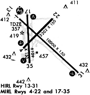
Runways
Runway Summary
| Runways: | 13/31 18/36 |
| Longest Runway: | 13/31 is 10000 ft (3048 m) long |
| Runways with an Instrument Approach: | 13 |
GGG Airport Runway Details
| Runway 13/31 | 10000 ft x 150 ft (3048 m x 46 m) | |
| Runway Length Source: | 3RD PARTY SURVEY as of 09/27/2017 | |
| Surface: | Asphalt - Good condition - Saw-cut or plastic grooved | |
| Runway Pavement Class: | 51 /F/C/X/T | |
| Runway Edge Lights: | High Intensity | |
Runway Weight Bearing Capacity (in thousands of pounds) |
||
| Single Wheel Landing Gear: | 95.0 | |
| Dual Wheel Landing Gear: | 155.0 | |
| Dual Tandem Wheel Landing Gear: | 288.0 | |
Runway 13 |
Runway 31 |
|
Elevation: |
357.7 | 353.9 |
Latitude: |
32-23-33.1593N | 32-22-24.6965N |
Longitude: |
094-43-12.4428W | 094-41-48.2605W |
|
Runway True Alignment: |
134 | 314 |
ILS Type: |
ILS | |
Glide Path Angle: |
0.0 degrees | 3.0 degrees |
Traffic Pattern: |
Left | Left |
Runway Markings Type: |
Precision Instrument | Precision Instrument |
Runway Markings Condition: |
Good | Good |
Visual Glide Slope Indicators: |
4-Light PAPI On Left Side Of Runway | |
Runway Visual Range (RVR): |
Touchdown | Rollout |
Approach Light System: |
1,400 Foot Medium Intensity Approach Lighting System With Runway Alignment Indicator Lights | |
Threshold Crossing Height: |
50 | |
Threshold Elevation: |
357.7 | |
Displaced Threshold: |
800 | |
Threshold Latitude: |
32-23-27.6785N | |
Threshold Longitude: |
094-43-05.7063W | |
Declared Distances |
||
Take Off Run Avbl. (TORA): |
10000 | 10000 |
Take Off Distance Avbl. (TODA): |
10000 | 10000 |
Actual Stop Dist. Avbl. (ASDA): |
10000 | 9200 |
Landing Dist. Avbl. (LDA): |
9200 | 9200 |
| Runway 18/36 | 6110 ft x 150 ft (1862 m x 46 m) | |
| Runway Length Source: | 3RD PARTY SURVEY as of 09/27/2017 | |
| Surface: | Asphalt - Good condition - Saw-cut or plastic grooved | |
| Runway Pavement Class: | 29 /F/C/X/T | |
| Runway Edge Lights: | Medium Intensity | |
Runway Weight Bearing Capacity (in thousands of pounds) |
||
| Single Wheel Landing Gear: | 95.0 | |
| Dual Wheel Landing Gear: | 155.0 | |
| Dual Tandem Wheel Landing Gear: | 280.0 | |
Runway 18 |
Runway 36 |
|
Elevation: |
354.3 | 365.5 |
Latitude: |
32-23-38.4301N | 32-22-37.9915N |
Longitude: |
094-43-00.1120W | 094-42-58.6065W |
|
Runway True Alignment: |
179 | 359 |
Glide Path Angle: |
3.0 degrees | 3.0 degrees |
Traffic Pattern: |
Left | Left |
Runway Markings Type: |
Nonprecision Instrument | Nonprecision Instrument |
Runway Markings Condition: |
Good | Good |
Object at End: |
TREE | TREE |
Object Height: |
46 | 52 |
Distance from End: |
1584 | 1813 |
Visual Glide Slope Indicators: |
4-Light PAPI On Left Side Of Runway | 4-Light PAPI On Right Side Of Runway |
Threshold Crossing Height: |
59 | 50 |
Declared Distances |
||
Take Off Run Avbl. (TORA): |
6109 | 6109 |
Take Off Distance Avbl. (TODA): |
6109 | 6109 |
Actual Stop Dist. Avbl. (ASDA): |
6109 | 6109 |
Landing Dist. Avbl. (LDA): |
6109 | 6109 |
Services
Airframe Repair: |
None |
Powerplant Repair: |
None |
Bottled Oxygen: |
None |
Bulk Oxygen: |
None |
Fuel Available: |
100LL |
Landing Fees: |
No |
Parking: |
Tiedowns available |
Maps & Diagrams
GGG Sectional
Flight Planning
at skyvector.com
at skyvector.com