Location
Latitude: |
32-49-11.1730N (32.81977) |
Longitude: |
097-21-44.8200W (-97.36245) |
Elevation: |
710.1 feet MSL (216 m MSL) |
Magnetic Variation: |
3 E (as of April 2024 from WMM2020 model) |
Time Zone: |
UTC -6.0 (Standard Time) UTC -5.0 (Daylight Savings Time) |
From City: |
05 N.M. N of Fort Worth, Texas |
Found On: |
Dallas-Ft Worth Chart |
FAA Region: |
ASW |
Contacts
Manager: |
Publicly owned: |
| AARON BARTH 201 AMERICAN CONCOURSE, SUITE 330 FORT WORTH, TX 76106-2749 817 392-5400 |
CITY OF FORT WORTH 1000 THROCKMORTON ST. FORT WORTH, TX 76102-6311 817-392-5400 |
Operations
Airport Status: |
Operational |
Facility Use: |
Public |
Type: |
Airport |
Activation Date: |
02/1938 |
Control tower: |
Yes |
Attendance (Months/Days/Hours): |
Months/Days/Hours ALL/ALL/ALL |
Boundary ARTCC: |
ZFW (Fort Worth) |
Responsible ARTCC: |
ZFW (Fort Worth) |
Lighting Schedule: |
SS-SR |
Segmented Circle Indicator: |
Yes |
Traffic Pattern Altitude (MSL): |
1710 feet (521 m) |
NOTAMs Facility: |
FTW |
NOTAM-D Service: |
Yes |
International Airport of Entry: |
No |
Customs Landing Rights: |
No |
Military Landing Rights: |
Yes |
Civil/Military Joint Use: |
No |
Aircraft Rescue and Firefighting: |
Class IV ARFF Index: A Air Carrier Service: Not Scheduled Certification Date: 12/1974 |
Based Aircraft
| Single Engine: | 106 |
| Multi Engine: | 53 |
| Jet Engine: | 110 |
| GA Helicopters: | 28 |
| Gliders: | 1 |
| Ultralights: | 1 |
Annual Operations (as of 03/01/2023)
| Total Operations: | 179005 | |
| Commercial: | 207 | 0.1% |
| Air Taxi: | 11973 | 6.7% |
| GA Local: | 92371 | 51.6% |
| GA Itinerant: | 71644 | 40.0% |
| Military Aircraft: | 2810 | 1.6% |
Communications
| Tower: | MEACHAM 118.3 257.8 Hrs: 24 |
| Clearance Del.: | 124.65 |
| Ground: | 121.9 |
| Approach: | REGIONAL |
| Departure: | REGIONAL |
| ATIS: | 120.7 Hrs: 24 |
| ASOS: | (817-740-3346) |
| EMERG: | 121.5 |
| EMERG: | 243.0 |
Fixed Based Operators (FBOs) & Fuel
(Click on a business for detail)
Please help us keep this information up to date. This is a FREE SERVICE just like everything else on Airport Guide! If you see that a business needs to be added, modified, or deleted please fill out our Update Form.
To add, modify, or delete a business click here.
Please help us keep this information up to date. This is a FREE SERVICE just like everything else on Airport Guide! If you see that a business needs to be added, modified, or deleted please fill out our Update Form.
Area Code: 817 |
| Business Name | Frequency | Phone | Fuel Grade |
|---|---|---|---|
| Air Carrier Avionics
Update FBO info |
626-2462 | ||
| Air Source One Pilot Shop
Update FBO info |
626-5550, 800-444-8044 | ||
| Broadies Aircraft and Engine Service
Update FBO info |
626-1532, 429-6936 | ||
| Byam Propeller Service
Update FBO info |
625-0161, 625-0006 | ||
| Fort Worth Jet Center
Update FBO info |
Unicom 122.95, Arinc 128.95 | 625-2366 | 100LL, Jet A |
| Richardson Aviation
Update FBO info |
Arinc 129.275 | 625-1611 | 100LL, Jet A |
| Sandpiper Airport Inn
Update FBO info |
Unicom 122.95, Arinc 131.5 | 625-5531 | 100LL, Jet A |
| Texas Avionics/Aviation Services
Update FBO info |
625-0192, -8025, 800-272-2022 | ||
| Texas Jet
Update FBO info |
Arinc 129.85 | 624-8438, 800-776-4547 | 100LL, Jet A |
Flight Service Stations
| Primary | Alternate | |
| FSS on Field: | N | |
| FSS Name (ID): | Fort Worth(FTW) | |
| Frequency: | ||
| Toll Free Phone: | 1-800-WX-BRIEF |
Instrument Procedures / Charts
FAA Terminal Procedures valid from 0901Z 03/21/24 to 0901Z 04/18/24.
There are various types of charts available for an airport. They are listed in the Page Type column. Here is a legend for those types:
APD - Airport Diagram
DP - Departure Procedure Charts
HOT - Hot Spots
IAP - Instrument Approach Procedure Charts
MIN - Minimums
STAR - Standard Terminal Arrival Charts
Terminal Procedures are only available for airports in several countries with more being added all the time. If you are looking for a specific country's charts, please send an email to support(at)airportguide.com stating the country name. This will be used to prioritize the implementation.
Navigation Aids (Navaids) near FTW
| Dist (NM) | ID | Morse Code | Name | Type | Freq | True Hdg | Mag Hdg |
|---|---|---|---|---|---|---|---|
| 0.1 | FTW | . . _ . _ . _ _ | Fort Worth | VOT | 108.20 | 279 | 276 |
| 4.4 | FT | . . _ . _ | Mufin | NDB | 365 | 352 | 349 |
| 4.8 | NFW | _ . . . _ . . _ _ | Nas Jrb Fort Worth | TACAN | 108.70 | 233 | 230 |
| 10.1 | FUZ | . . _ . . . _ _ _ . . | Ranger | VORTAC | 115.70 | 65 | 62 |
| 16.5 | TTT | _ _ _ | Maverick | VOR-DME | 113.10 | 79 | 76 |
| 23.5 | CVE | _ . _ . . . . _ . | Cowboy | VOR-DME | 116.20 | 79 | 76 |
| 26.1 | DAL | _ . . . _ . _ . . | Dallas | VOT | 113.30 | 85 | 82 |
| 29.0 | DT | _ . . _ | Pinck | NDB | 257 | 16 | 13 |
| 32.5 | MQP | _ _ _ _ . _ . _ _ . | Millsap | VORTAC | 117.70 | 260 | 257 |
| 42.0 | PQF | . _ _ . _ _ . _ . . _ . | Mesquite | NDB | 248 | 90 | 87 |
| 42.9 | JUG | . _ _ _ . . _ _ _ . | Jecca | NDB | 388 | 102 | 99 |
| 47.1 | VLY | . . . _ . _ . . _ . _ _ | Melisa | NDB | 421 | 55 | 52 |
| 47.4 | JEN | . _ _ _ . _ . | Glen Rose | TACAN | 115.00 | 213 | 210 |
| 48.8 | UKW | . . _ _ . _ . _ _ | Bowie | VORTAC | 117.15 | 331 | 328 |
| 51.5 | GMZ | _ _ . _ _ _ _ . . | Grindstone Mountain | NDB | 356 | 336 | 333 |
| 56.3 | AVZ | . _ . . . _ _ _ . . | Travis | NDB | 260 | 93 | 90 |
| 57.7 | MII | _ _ . . . . | Caddo Mills | NDB | 316 | 76 | 73 |
| 60.7 | GHX | _ _ . . . . . _ . . _ | Graham | NDB | 371 | 290 | 287 |
| 65.6 | CGQ | _ . _ . _ _ . _ _ . _ | Powell | NDB | 344 | 133 | 130 |
| 66.0 | SYW | . . . _ . _ _ . _ _ | Cash | NDB | 428 | 81 | 78 |
Nearby Airports with Fuel
Notices to Airmen (NOTAMS)
Remarks
| A110-34 | RWY 17/35, TWYS B, B1, C AND D WEST OF RWY 16/34, TWY M EAST OF TWY A, H, J, TXL G SE OF TXL N CLSD TO ACR ACFT WITH MORE THAN 30 PSGR SEATS. |
| A110-38 | RWY 17/35 DESIGNED FOR ACFT WITH WINGSPAN 49 FT OR LESS. TWYS B & B1 DESIGNED FOR ACFT WITH WINGSPAN LESS THAN 79 FT. RWY 16/34 & TWYS A, A1 & M DESIGNED FOR ACFT WITH WINGSPAN LESS THAN 171 FT. ALL OTHER TWYS DESIGNED FOR ACFT WITH WINGSPAN LESS THAN 118 FT. |
| A110-39 | H1 & H2 HELIPADS ARE VMC DALGT USE ONLY; NON-MOVEMENT AREA. |
| A110-43 | MKD US CUST PRKG SOUTHEAST OF TXL G AND TXL N INTXN. |
| A110-44 | HELO SKIDDING OPNS PROHIBITED ON RWY 17/35. IF SKIDDING IS RQRD, COORD WITH ATCT TO USE TWY B. |
| A110-45 | PPR FOR ACR OPNS WITH MORE THAN 30 PSGR SEATS - 24 HR NOTICE RQRD - CALL ARPT OPS 817-994-0653. |
| A110-46 | ARPT FEES FOR USE OF CUST SVCS WILL BE COLLD IMT UPON LDG BY CITY OF FORT WORTH ARPT OPNS PSNL. |
| A110-47 | RWY 17/35 LED LGT CAN APPR BRGTR THAN RWY 16/34; ENSURE COR RWY ALNMT. |
| A110-48 | HELS REPOSITIONING BYD IMT PRKG APRON AND UNDER THEIR OWN PWR MUST CTC ATC. |
| A110-49 | ARFF INDEX B AVBL ALL USERS WITH PPR. |
| A110-6 | BIRDS ON & INVOF ARPT. |
| A26 | ARFF INDEX A OR HIGHER AVBL ALL USERS WITH PPR. |
| E147 | TPA - RWY 17/35 R/W 1300(590) AGL, F/W 1500(790) AGL, RWY 16/34 1500(790) AGL, JETS 2000(1290) AGL. |
| E80 | US CUSTOMS USER FEE ARPT. |
Runways
Runway Summary
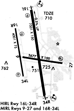
| Runways: | 16/34 17/35 H1 H2 |
| Longest Runway: | 16/34 is 7502 ft (2287 m) long |
| Runways with an Instrument Approach: | 16, 34 |
FTW Heliport Runway Details
| Runway 16/34 | 7502 ft x 150 ft (2287 m x 46 m) | |
| Runway Length Source: | 3RD PARTY SURVEY as of 02/16/2010 | |
| Surface: | Concrete - Good condition - Saw-cut or plastic grooved | |
| Runway Pavement Class: | 30 /R/C/W/U | |
| Runway Edge Lights: | High Intensity | |
Runway Weight Bearing Capacity (in thousands of pounds) |
||
| Single Wheel Landing Gear: | 80.0 | |
| Dual Wheel Landing Gear: | 100.0 | |
| Dual Tandem Wheel Landing Gear: | 190.0 | |
| Dual Dual Tandem Wheel Landing Gear: | 350.0 | |
Runway 16 |
Runway 34 |
|
Elevation: |
710.1 | 674.0 |
Latitude: |
32-49-48.6376N | 32-48-35.1564N |
Longitude: |
097-21-44.9518W | 097-21-32.5720W |
|
Runway True Alignment: |
172 | 352 |
ILS Type: |
ILS/DME | ILS/DME |
Glide Path Angle: |
3.0 degrees | 0.0 degrees |
Traffic Pattern: |
Left | Right |
Runway Markings Type: |
Precision Instrument | Precision Instrument |
Runway Markings Condition: |
Good | Good |
Object at End: |
POLE | |
Object Height: |
31 | |
Distance from End: |
1450 | |
Object Centerline Offset: |
625 ft. left of centerline | |
Visual Glide Slope Indicators: |
4-Light PAPI On Right Side Of Runway | |
Runway Visual Range (RVR): |
Touchdown | Rollout |
Approach Light System: |
1,400 Foot Medium Intensity Approach Lighting System With Runway Alignment Indicator Lights | 1,400 Foot Medium Intensity Approach Lighting System |
REIL: |
No | No |
Threshold Crossing Height: |
59 | |
Declared Distances |
||
Take Off Run Avbl. (TORA): |
7502 | 7502 |
Take Off Distance Avbl. (TODA): |
7502 | 7502 |
Actual Stop Dist. Avbl. (ASDA): |
7502 | 7455 |
Landing Dist. Avbl. (LDA): |
7502 | 7455 |
| Runway 17/35 | 4005 ft x 75 ft (1221 m x 23 m) | |
| Runway Length Source: | 3RD PARTY SURVEY as of 02/16/2010 | |
| Surface: | Concrete - Good condition - No special surface treatment | |
| Runway Pavement Class: | 11 /F/C/X/U | |
| Runway Edge Lights: | Medium Intensity | |
Runway Weight Bearing Capacity (in thousands of pounds) |
||
| Single Wheel Landing Gear: | 12.5 | |
| Dual Wheel Landing Gear: | 50.0 | |
Runway 17 |
Runway 35 |
|
Elevation: |
668.2 | 667.2 |
Latitude: |
32-49-29.4222N | 32-48-50.2115N |
Longitude: |
097-21-59.4712W | 097-21-52.8641W |
|
Runway True Alignment: |
172 | 352 |
Glide Path Angle: |
3.8 degrees | 3.2 degrees |
Traffic Pattern: |
Right | Left |
Runway Markings Type: |
Nonprecision Instrument | Nonprecision Instrument |
Runway Markings Condition: |
Good | Good |
Object at End: |
BERM | |
Object Height: |
39 | |
Object Marked/Lighted?: |
Lighted | |
Distance from End: |
1361 | |
Object Centerline Offset: |
625 ft. left of centerline | |
Visual Glide Slope Indicators: |
2-Light PAPI On Left Side Of Runway | 2-Light PAPI On Left Side Of Runway |
Threshold Crossing Height: |
56 | 43 |
| Helipad H1 | 35 ft x 35 ft (11 m x 11 m) | |
| Runway Length Source: | FAA as of 05/06/2011 | |
| Surface: | Concrete - Good condition - No special surface treatment | |
Helipad H1 |
||
Elevation: |
710.1 | |
Latitude: |
32-49-09.2600N | |
Longitude: |
097-21-59.6300W | |
Glide Path Angle: |
0.0 degrees | 0.0 degrees |
Runway Markings Type: |
None | |
Runway Markings Condition: |
Good | |
Object Centerline Offset: |
625 ft. left of centerline |
| Helipad H2 | 35 ft x 35 ft (11 m x 11 m) | |
| Runway Length Source: | FAA as of 05/06/2011 | |
| Surface: | Concrete - Good condition - No special surface treatment | |
Helipad H2 |
||
Elevation: |
668.7 | |
Latitude: |
32-49-05.9800N | |
Longitude: |
097-21-59.0700W | |
Glide Path Angle: |
0.0 degrees | 0.0 degrees |
Runway Markings Type: |
None | |
Runway Markings Condition: |
Fair | |
Object Centerline Offset: |
625 ft. left of centerline |
Services
Airframe Repair: |
Major |
Powerplant Repair: |
Major |
Fuel Available: |
100LL, Jet A |
Parking: |
Hangars and tiedowns available |
Maps & Diagrams
FTW Sectional
Flight Planning
at skyvector.com
at skyvector.com