Location
Latitude: |
32-40-52.7000N (32.681306) |
Longitude: |
096-52-07.6000W (-96.868778) |
Elevation: |
660.5 feet MSL (201 m MSL) |
Magnetic Variation: |
2.7 E (as of April 2024 from WMM2020 model) |
Time Zone: |
UTC -6.0 (Standard Time) UTC -5.0 (Daylight Savings Time) |
From City: |
06 N.M. SW of Dallas, Texas |
Found On: |
Dallas-Ft Worth Chart |
FAA Region: |
ASW |
Contacts
Manager: |
Publicly owned: |
| RAFAEL GARZA JR. 5303 CHALLENGER DR. DALLAS, TX 75237 214-670-7612 |
CITY OF DALLAS 1500 MARILLA DALLAS, TX 75201 214-670-7612 |
Operations
Airport Status: |
Operational |
Facility Use: |
Public |
Type: |
Airport |
Activation Date: |
09/1948 |
Control tower: |
Yes |
Attendance (Months/Days/Hours): |
Months/Days/Hours ALL/ALL/0600-2000 |
Boundary ARTCC: |
ZFW (Fort Worth) |
Responsible ARTCC: |
ZFW (Fort Worth) |
Lighting Schedule: |
SEE RMK |
Segmented Circle Indicator: |
Yes |
Traffic Pattern Altitude (MSL): |
1660 feet (506 m) |
NOTAMs Facility: |
RBD |
NOTAM-D Service: |
Yes |
Based Aircraft
| Single Engine: | 242 |
| Multi Engine: | 47 |
| Jet Engine: | 52 |
| GA Helicopters: | 15 |
| Gliders: | 2 |
Annual Operations (as of 06/30/2023)
| Total Operations: | 93192 | |
| Air Taxi: | 619 | 0.7% |
| GA Local: | 41565 | 44.6% |
| GA Itinerant: | 50913 | 54.6% |
| Military Aircraft: | 95 | 0.1% |
Communications
| CTAF: | 127.250 |
| Unicom: | 122.950 |
| Tower: | EXECUTIVE 127.25 Hrs: 0700-2100 |
| Clearance Del.: | 118.625 |
| Ground: | 119.475 |
| Approach: | REGIONAL |
| Departure: | REGIONAL |
| ATIS: | 126.35 Hrs: 24 |
| ASOS: | (214-330-5317) |
| EMERG: | 121.5 |
Fixed Based Operators (FBOs) & Fuel
(Click on a business for detail)
Please help us keep this information up to date. This is a FREE SERVICE just like everything else on Airport Guide! If you see that a business needs to be added, modified, or deleted please fill out our Update Form.
To add, modify, or delete a business click here.
Please help us keep this information up to date. This is a FREE SERVICE just like everything else on Airport Guide! If you see that a business needs to be added, modified, or deleted please fill out our Update Form.
Area Code: 214 |
| Business Name | Frequency | Phone | Fuel Grade |
|---|---|---|---|
| Northern Texas Piper Sales, Inc.
Update FBO info |
340-6780 office, 341-8143 parts | ||
| Redbird Electronics
Update FBO info |
Unicom 122.95 | 337-8958 | |
| Slipstream Aviation
Website Update FBO info |
817-658-5988 |
Flight Service Stations
| Primary | Alternate | |
| FSS on Field: | N | |
| FSS Name (ID): | Fort Worth(FTW) | |
| Frequency: | ||
| Toll Free Phone: | 1-800-WX-BRIEF |
Instrument Procedures / Charts
FAA Terminal Procedures valid from 0901Z 03/21/24 to 0901Z 04/18/24.
There are various types of charts available for an airport. They are listed in the Page Type column. Here is a legend for those types:
APD - Airport Diagram
DP - Departure Procedure Charts
HOT - Hot Spots
IAP - Instrument Approach Procedure Charts
MIN - Minimums
STAR - Standard Terminal Arrival Charts
Terminal Procedures are only available for airports in several countries with more being added all the time. If you are looking for a specific country's charts, please send an email to support(at)airportguide.com stating the country name. This will be used to prioritize the implementation.
Navigation Aids (Navaids) near RBD
| Dist (NM) | ID | Morse Code | Name | Type | Freq | True Hdg | Mag Hdg |
|---|---|---|---|---|---|---|---|
| 10.5 | DAL | _ . . . _ . _ . . | Dallas | VOT | 113.30 | 5 | 2 |
| 12.7 | CVE | _ . _ . . . . _ . | Cowboy | VOR-DME | 116.20 | 351 | 348 |
| 14.2 | TTT | _ _ _ | Maverick | VOR-DME | 113.10 | 322 | 319 |
| 17.0 | JUG | . _ _ _ . . _ _ _ . | Jecca | NDB | 388 | 92 | 89 |
| 18.8 | PQF | . _ _ . _ _ . _ . . _ . | Mesquite | NDB | 248 | 65 | 62 |
| 20.0 | FUZ | . . _ . . . _ _ _ . . | Ranger | VORTAC | 115.70 | 308 | 305 |
| 26.3 | FTW | . . _ . _ . _ _ | Fort Worth | VOT | 108.20 | 288 | 285 |
| 28.4 | FT | . . _ . _ | Mufin | NDB | 365 | 296 | 293 |
| 29.3 | NFW | _ . . . _ . . _ _ | Nas Jrb Fort Worth | TACAN | 108.70 | 280 | 277 |
| 31.6 | AVZ | . _ . . . _ _ _ . . | Travis | NDB | 260 | 81 | 78 |
| 37.6 | VLY | . . . _ . _ . . _ . _ _ | Melisa | NDB | 421 | 21 | 18 |
| 38.0 | MII | _ _ . . . . | Caddo Mills | NDB | 316 | 55 | 52 |
| 39.7 | DT | _ . . _ | Pinck | NDB | 257 | 335 | 332 |
| 43.3 | CGQ | _ . _ . _ _ . _ _ . _ | Powell | NDB | 344 | 148 | 145 |
| 44.2 | SYW | . . . _ . _ _ . _ _ | Cash | NDB | 428 | 65 | 63 |
| 44.4 | CQY | _ . _ . _ _ . _ _ . _ _ | Cedar Creek | VORTAC | 114.80 | 131 | 129 |
| 46.0 | CRS | _ . _ . . _ . . . . | Corsicana | NDB | 396 | 148 | 145 |
| 46.8 | MJF | _ _ . _ _ _ . . _ . | Arvilla | TACAN | 109.60 | 60 | 58 |
| 57.0 | MQP | _ _ _ _ . _ . _ _ . | Millsap | VORTAC | 117.70 | 273 | 270 |
| 59.2 | CSZ | _ . _ . . . . _ _ . . | Crossroads | NDB | 215 | 128 | 126 |
Nearby Airports with Fuel
Notices to Airmen (NOTAMS)
Remarks
| A110-1 | BIRDS ON & INVOF ARPT. |
| A17 | ON CALL AFT HRS. |
| A57-13 | APCH SLOPE 0:1 TO DSPLCD THLD OVR 20 FT TREES, 0 FT DSTC, 395 FT R. |
| A58-13 | 25 FT TREES, 0-199 FT DSTC, 380 FT R, 413 FT L. |
| A70-FUEL-10 | 0LL FUEL AVBL 24 HR. |
| A81-APT | WHEN ATCT CLSD MIRL RWYS 13/31& 17/35 PRESET LOW INTST; TO INCR INTST ACTVT - CTAF. |
| E111 | PRE-DATES ACT. |
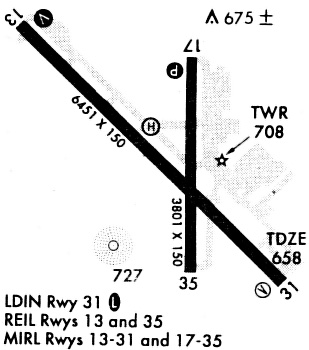
Runways
Runway Summary
| Runways: | 13/31 17/35 |
| Longest Runway: | 13/31 is 7136 ft (2175 m) long |
| Runways with an Instrument Approach: | 31 |
RBD Airport Runway Details
| Runway 13/31 | 7136 ft x 100 ft (2175 m x 30 m) | |
| Runway Length Source: | 3RD PARTY SURVEY as of 10/20/2016 | |
| Surface: | Concrete - Excellent condition - Saw-cut or plastic grooved | |
| Runway Edge Lights: | Medium Intensity | |
Runway Weight Bearing Capacity (in thousands of pounds) |
||
| Single Wheel Landing Gear: | 40.0 | |
| Dual Wheel Landing Gear: | 90.0 | |
| Dual Tandem Wheel Landing Gear: | 130.0 | |
Runway 13 |
Runway 31 |
|
Elevation: |
653.4 | 646.9 |
Latitude: |
32-41-19.1600N | 32-40-29.1582N |
Longitude: |
096-52-40.8100W | 096-51-41.8651W |
|
Runway True Alignment: |
135 | 315 |
ILS Type: |
ILS/DME | |
Glide Path Angle: |
3.0 degrees | 3.0 degrees |
Traffic Pattern: |
Left | Left |
Runway Markings Type: |
Nonprecision Instrument | Precision Instrument |
Runway Markings Condition: |
Good | Good |
Object at End: |
TREES | ROAD |
Object Height: |
25 | 7 |
Distance from End: |
201 | 547 |
Object Centerline Offset: |
380 ft. right of centerline | 513 ft. right of centerline |
Visual Glide Slope Indicators: |
4-Light PAPI On Left Side Of Runway | 4-Light PAPI On Right Side Of Runway |
REIL: |
Yes | Yes |
Threshold Crossing Height: |
40 | 45 |
Threshold Elevation: |
656.3 | 649.7 |
Displaced Threshold: |
1085 | 500 |
Threshold Latitude: |
32-41-11.5534N | 32-40-32.6565N |
Threshold Longitude: |
096-52-31.8494W | 096-51-45.9866W |
Declared Distances |
||
Take Off Run Avbl. (TORA): |
6766 | 6051 |
Take Off Distance Avbl. (TODA): |
7136 | 7136 |
Actual Stop Dist. Avbl. (ASDA): |
6622 | 7101 |
Landing Dist. Avbl. (LDA): |
5537 | 6601 |
| Runway 17/35 | 3800 ft x 150 ft (1158 m x 46 m) | |
| Runway Length Source: | 3RD PARTY SURVEY as of 10/20/2016 | |
| Surface: | Concrete - Excellent condition - No special surface treatment | |
| Runway Edge Lights: | Medium Intensity | |
Runway Weight Bearing Capacity (in thousands of pounds) |
||
| Single Wheel Landing Gear: | 35.0 | |
| Dual Wheel Landing Gear: | 60.0 | |
| Dual Tandem Wheel Landing Gear: | 110.0 | |
Runway 17 |
Runway 35 |
|
Elevation: |
650.6 | 659.2 |
Latitude: |
32-41-08.8765N | 32-40-31.2846N |
Longitude: |
096-52-00.4499W | 096-52-00.5507W |
|
Runway True Alignment: |
180 | 000 |
Glide Path Angle: |
3.0 degrees | 0.0 degrees |
Traffic Pattern: |
Left | Left |
Runway Markings Type: |
Nonprecision Instrument | Nonprecision Instrument |
Runway Markings Condition: |
Good | Good |
Object Centerline Offset: |
380 ft. right of centerline | 513 ft. right of centerline |
Visual Glide Slope Indicators: |
4-Light PAPI On Right Side Of Runway | |
REIL: |
Yes | Yes |
Threshold Crossing Height: |
43 |
Services
Airframe Repair: |
Major |
Powerplant Repair: |
Major |
Bottled Oxygen: |
None |
Bulk Oxygen: |
None |
Fuel Available: |
100LL, Jet A |
Landing Fees: |
No |
Parking: |
Hangars and tiedowns available |
Maps & Diagrams
RBD Sectional
Flight Planning
at skyvector.com
at skyvector.com