


Location
Latitude: |
29-10-47.6720N (29.179909) |
Longitude: |
081-03-28.9520W (-81.058042) |
Elevation: |
34.2 feet MSL (10 m MSL) |
Magnetic Variation: |
7.1 W (as of May 2024 from WMM2020 model) |
Time Zone: |
UTC -5.0 (Standard Time) UTC -4.0 (Daylight Savings Time) |
From City: |
03 N.M. SW of Daytona Beach, Florida |
Found On: |
Jacksonville Chart |
FAA Region: |
ASO |
Contacts
Manager: |
Publicly owned: |
| MS KAREN K FEASTER, AAE, IACE, ACE 700 CATALINA DR, SUITE 300, DAYTONA BEACH INTL ARPT DAYTONA BEACH, FL 32114 386-248-8030 |
VOLUSIA COUNTY 123 W INDIANA AVE DELAND, FL 32720-4612 386-248-8030 |
Operations
Airport Status: |
Operational |
Facility Use: |
Public |
Type: |
Airport |
Activation Date: |
04/1940 |
Control tower: |
Yes |
Attendance (Months/Days/Hours): |
Months/Days/Hours ALL/ALL/ALL |
Boundary ARTCC: |
ZJX (Jacksonville) |
Responsible ARTCC: |
ZJX (Jacksonville) |
Lighting Schedule: |
SS-SR |
Segmented Circle Indicator: |
No |
Traffic Pattern Altitude (MSL): |
1034 feet (315 m) |
NOTAMs Facility: |
DAB |
NOTAM-D Service: |
Yes |
International Airport of Entry: |
No |
Customs Landing Rights: |
No |
Military Landing Rights: |
Yes |
Civil/Military Joint Use: |
No |
Aircraft Rescue and Firefighting: |
Class I ARFF Index: C Air Carrier Service: Scheduled Certification Date: 05/1973 |
Based Aircraft
| Single Engine: | 196 |
| Multi Engine: | 39 |
| Jet Engine: | 24 |
| GA Helicopters: | 1 |
Annual Operations (as of 10/31/2023)
| Total Operations: | 382739 | |
| Commercial: | 6284 | 1.6% |
| Air Taxi: | 174678 | 45.6% |
| GA Local: | 153761 | 40.2% |
| GA Itinerant: | 46991 | 12.3% |
| Military Aircraft: | 1025 | 0.3% |
Communications
| Unicom: | 122.950 |
| Tower: | DAYTONA 120.7 257.8 Hrs: 24 |
| Clearance Del.: | 119.3 |
| Ground: | 121.9 348.6 |
| Approach: | DAYTONA 118.85 ;N 4000-7500 125.35 ;S 3500 FT & BLW 125.725 ;8000-11000 FT 125.8 ;N 3500 FT & BLW 127.075 ;S 4000-7500 269.075 ;N 3500 FT & BLW 322.3 ;S 3500 FT & BLW 351.95 ;S 4000-8500 351.95 ;S 4000-8500 353.825 ;N 4000-8500 379.95 ;9000 FT & ABV Hrs: 24 |
| Departure: | DAYTONA 118.85 ;N 4000-7500 125.35 ;S 3500 FT & BLW 125.725 ;8000-11000 FT 125.8 ;N 3500 FT & BLW 127.075 ;S 4000-7500 269.075 ;N 3500 FT & BLW 322.3 ;S 3500 FT & BLW 351.95 ;S 4000-8500 351.95 ;S 4000-8500 353.825 ;N 4000-8500 379.95 ;9000 FT & ABV Hrs: 24 |
| ATIS: | 132.875 Hrs: 24 |
| ASOS: | (386-257-6444) |
| CLASS C: | 125.35 ;S 3500 FT & BLW |
| CLASS C: | 269.075 ;N 3500 FT & BLW |
| ROYES DP: | 353.825 |
| LAMMA DP: | 118.85 |
| TTHOR STAR: | 353.825 |
| ROYES DP: | 118.85 |
| TTHOR STAR: | 118.85 |
| CLASS C: | 125.8 ;N 3500 FT & BLW |
| CLASS C: | 322.3 ;S 3500 FT & BLW |
| EMERG: | 121.5 |
| EMERG: | 243.0 |
| LAMMA DP: | 353.825 |
Fixed Based Operators (FBOs) & Fuel
(Click on a business for detail)
Please help us keep this information up to date. This is a FREE SERVICE just like everything else on Airport Guide! If you see that a business needs to be added, modified, or deleted please fill out our Update Form.
To add, modify, or delete a business click here.
Please help us keep this information up to date. This is a FREE SERVICE just like everything else on Airport Guide! If you see that a business needs to be added, modified, or deleted please fill out our Update Form.
Area Code: 904 |
| Business Name | Frequency | Phone | Fuel Grade |
|---|---|---|---|
| Cloud Dancer Aviation
Update FBO info |
238-7270 | 100LL | |
| Embry-Riddle Aeronautical University
Update FBO info |
Unicom 123.5 | 226-6175 | |
| Executive Flightline, Inc.
Website Update FBO info |
122.6 | 386-248-0458 | 100LL, Jet A |

|
 Exxon |
100LL - 2.24 USD per gallon on 8/15/01 |
24 Hour Self Serve Credit Card Pumps |
|
|
Exxon |
Jet A - 1.98 USD per gallon on 8/15/01 |
24 Hour Self Serve Credit Card Pumps |
| Jet Center Daytona Beach
Update FBO info |
Unicom 122.95, Arinc 130.1 | 255-0471, 800-883-5388 | 100LL, Jet A |
| PhilAir Flight Center
Update FBO info |
Unicom 122.95 | 253-9222 | |
| Phoenix East Aviation
Update FBO info |
258-0703 | ||
| Regional Flight Training
Update FBO info |
257-7731 | ||
| Ultimate Air Academy
Website Update FBO info |
386-868-0985 | 100LL | |
|
|
 Shell |
100LL - 5.96 USD per gallon on 7/22/11 |
24 Hour Self Serve Credit Card Pumps |
| Willman Aviation
Update FBO info |
255-5982 | ||
| Wrightway Aviation Center, L.L.C.
Update FBO info |
254-7878 | ||
| Yelvington Jet Aviation, Inc.
Update FBO info |
Unicom 122.95, Arinc 129.7 | 257-7791, 888-322-5382 | 100LL, Jet A |
Flight Service Stations
| Primary | Alternate | |
| FSS on Field: | N | |
| FSS Name (ID): | Saint Petersburg(PIE) | |
| Frequency: | ||
| Toll Free Phone: | 1-800-WX-BRIEF |
Instrument Procedures / Charts
FAA Terminal Procedures valid from 0901Z 03/21/24 to 0901Z 04/18/24.
There are various types of charts available for an airport. They are listed in the Page Type column. Here is a legend for those types:
APD - Airport Diagram
DP - Departure Procedure Charts
HOT - Hot Spots
IAP - Instrument Approach Procedure Charts
MIN - Minimums
STAR - Standard Terminal Arrival Charts
| Page Type | Page Name | Volume | Action Since Last Cycle |
|---|---|---|---|
| APD | AIRPORT DIAGRAM | SE-3 | |
| DP | ROYES SEVEN | SE-3 | |
| IAP | ILS OR LOC RWY 07L | SE-3 | |
| IAP | ILS OR LOC RWY 25R | SE-3 | |
| IAP | RNAV (GPS) RWY 07L | SE-3 | |
| IAP | RNAV (GPS) RWY 07R | SE-3 | |
| IAP | RNAV (GPS) RWY 16 | SE-3 | |
| IAP | RNAV (GPS) RWY 25L | SE-3 | |
| IAP | RNAV (GPS) RWY 25R | SE-3 | |
| IAP | RNAV (GPS) RWY 34 | SE-3 | |
| LAH | LAHSO | SE-3 | |
| MIN | ALTERNATE MINIMUMS | SE-3 | |
| MIN | TAKEOFF MINIMUMS | SE-3 | |
| STAR | TTHOR THREE (RNAV) | SE-3 | |
| STAR | TTHOR THREE (RNAV)[DELIMITER] CONT.1 | SE-3 |
Terminal Procedures are only available for airports in several countries with more being added all the time. If you are looking for a specific country's charts, please send an email to support(at)airportguide.com stating the country name. This will be used to prioritize the implementation.
Navigation Aids (Navaids) near DAB
| Dist (NM) | ID | Morse Code | Name | Type | Freq | True Hdg | Mag Hdg |
|---|---|---|---|---|---|---|---|
| 0.1 | DAB | _ . . . _ _ . . . | Daytona Beach | VOT | 111.00 | 57 | 64 |
| 7.9 | OMN | _ _ _ _ _ _ . | Ormond Beach | VORTAC | 112.60 | 338 | 345 |
| 9.7 | EVB | . . . . _ _ . . . | New Smyrna Beach | NDB | 417 | 140 | 147 |
| 13.2 | DED | _ . . . _ . . | Deland/Dcmsnd | NDB | 201 | 239 | 246 |
| 25.6 | SFB | . . . . . _ . _ . . . | Sanford | NDB | 408 | 202 | 209 |
| 40.9 | ORL | _ _ _ . _ . . _ . . | Orlando | VORTAC | 112.20 | 200 | 207 |
| 42.4 | TVV | _ . . . _ . . . _ | Space Center Executive | NDB | 237 | 160 | 167 |
| 44.9 | LEE | . _ . . . . | Leesburg | NDB | 335 | 241 | 248 |
| 45.0 | OR | _ _ _ . _ . | Herny | NDB | 221 | 206 | 213 |
| 48.6 | IAK | . . . _ _ . _ | Palatka | NDB | 243 | 305 | 312 |
| 48.7 | SGJ | . . . _ _ . . _ _ _ | St Augustine | VOR-DME | 109.40 | 343 | 350 |
| 56.6 | RYD | . _ . _ . _ _ _ . . | Reynolds | NDB | 338 | 326 | 333 |
| 61.2 | OCF | _ _ _ _ . _ . . . _ . | Ocala | VORTAC | 113.70 | 270 | 277 |
| 61.2 | COF | _ . _ . _ _ _ . . _ . | Patrick | TACAN | 115.00 | 157 | 164 |
| 65.2 | GN | _ _ . _ . | Wynds | NDB | 269 | 297 | 304 |
| 67.5 | SQT | . . . _ _ . _ _ | Satellite | NDB | 257 | 163 | 170 |
| 68.2 | MLB | _ _ . _ . . _ . . . | Melbourne | VOR-DME | 115.85 | 160 | 167 |
| 70.5 | GNV | _ _ . _ . . . . _ | Gators | VORTAC | 116.20 | 296 | 303 |
| 71.0 | NIP | _ . . . . _ _ . | Jacksonville | TACAN | 108.20 | 333 | 340 |
| 73.4 | CRG | _ . _ . . _ . _ _ . | Craig | VORTAC | 114.50 | 341 | 348 |
Nearby Airports with Fuel
Notices to Airmen (NOTAMS)
Remarks
| A110-1 | FLT TRNG & BIRDS ON & INVOF & DRONE ACT NE OF ARPT; BIRDS OVER LANDFILL 3.5 NM SW. |
| A110-10 | TWY P3 & P4 HAVE NO SIGNS OR MARKING. |
| A110-11 | USE CO FLY QUIET PROC OR RCMD NOISE ABATEMENT PROC - AMGR |
| A110-12 | SFC COND NOT MNTD 2100-0500. |
| A110-16 | PPR FOR DAYTONA BEACH SPEEDWAY LOW APCH OR FLY-OVER - DAB ATC. |
| A110-17 | ROTOR WING HEL MUST GRND TAXI; IF UNABL USE CTN DURG HOVER TAXI. |
| A110-19 | US CUSTS RAMP RSTRD GROUP II ACFT OF WINGSPAN 79 FT OR LESS. |
| A110-2 | TWY S EAST END IS NON-MOVEMENT AREA. |
| A110-22 | TWY C1 CLSD TO ACFT WINGSPAN MORE THAN 119 FT; TWY W CLSD TO ACFT WINGSPAN MORE THAN 119 FT; TWY W3 CLSD TO ACFT WINGSPAN MORE THAN 79 FT. |
| A110-23 | TWY W BTN RWY 16 APCH END & TWY A CLSD TO MIL HEL & HOVER TAXI OPS. |
| A110-24 | TWY W BTN TWY A & RWY 16 APCH END CLSD TO ROTARY WING WITH ROTAR SPAN MORE THAN 50 FT EXC 1 HR PPR - 386-527-0657. |
| A110-4 | TWY E RSTRD TO 22000 LBS MAX CRTFYD GROSS TKOF WEIGHT; TWY P RSTRD TO 190500 LBS MAX CRTFYD GROSS TKOF WEIGHT. |
| A110-8 | TWY N NORTHWEST OF RWY 7L & NORTHEAST OF RWY 25R CAN BE MISTAKEN FOR RWY & APCH ENVIRONMENT. |
| A30-07R/25L | SKED ACR OPS MORE THAN 9 PAX SEATS OR UNSKED ACR AT LEAST 31 PAX SEATS NA. |
| A31-07L/25R | FIRST 2300 FT RWY 7L CONCRETE ON 50 FT WIDE KEEL SECTION. |
| A33-07R/25L | OUTER EDGES OF PAVEMENT UNEVEN. |
| A43-25R | PAPI UNUSBL BYD 5 DEG LEFT & RIGHT OF CNTRLN. |
| A57-07L | RWY 07L APCH SLP 50:1 TO DSPLCD THR. |
| E147 | TPA FOR LGT ACFT 965 FT AGL; TPA FOR HI PER ACFT 1365 FT AGL. |
| E80 | US CUSTOMS USER FEE ARPT. |
Runways
Runway Summary
| Runways: | 07L/25R 07R/25L 16/34 |
| Longest Runway: | 07L/25R is 10500 ft (3200 m) long |
| Runways with an Instrument Approach: | 07L, 25R |
DAB Airport Runway Details
| Runway 07L/25R | 10500 ft x 150 ft (3200 m x 46 m) | |
| Runway Length Source: | 3RD PARTY SURVEY as of 06/05/2017 | |
| Surface: | Asphalt/Concrete - Good condition - Saw-cut or plastic grooved | |
| Runway Pavement Class: | 66 /R/B/W/T | |
| Runway Edge Lights: | High Intensity | |
Runway Weight Bearing Capacity (in thousands of pounds) |
||
| Single Wheel Landing Gear: | 120.0 | |
| Dual Wheel Landing Gear: | 224.0 | |
| Dual Tandem Wheel Landing Gear: | 402.0 | |
| Dual Dual Tandem Wheel Landing Gear: | 915.0 | |
Runway 07L |
Runway 25R |
|
Elevation: |
28.3 | 32.7 |
Latitude: |
29-10-21.1794N | 29-11-04.7458N |
Longitude: |
081-04-40.0358W | 081-02-52.4957W |
|
Runway True Alignment: |
065 | 245 |
ILS Type: |
LOC/GS | ILS/DME |
Glide Path Angle: |
0.0 degrees | 3.0 degrees |
Traffic Pattern: |
Left | Right |
Runway Markings Type: |
Precision Instrument | Precision Instrument |
Runway Markings Condition: |
Good | Good |
Object at End: |
ROAD | TREES |
Object Height: |
15 | 43 |
Distance from End: |
790 | 2370 |
Object Centerline Offset: |
500 ft. left of centerline | 230 ft. left of centerline |
Visual Glide Slope Indicators: |
4-Light PAPI On Left Side Of Runway | |
Runway Visual Range (RVR): |
Touchdown | Rollout |
Approach Light System: |
1,400 Foot Medium Intensity Approach Lighting System With Runway Alignment Indicator Lights | 1,400 Foot Medium Intensity Approach Lighting System With Runway Alignment Indicator Lights |
REIL: |
No | No |
Touchdown Lights: |
Yes | |
Centerline Lights: |
Yes | Yes |
Threshold Crossing Height: |
72 | |
Threshold Elevation: |
28.7 | |
Displaced Threshold: |
690 | |
Threshold Latitude: |
29-10-24.0454N | |
Threshold Longitude: |
081-04-32.9669W | |
Declared Distances |
||
Take Off Run Avbl. (TORA): |
10500 | 10500 |
Take Off Distance Avbl. (TODA): |
10500 | 10500 |
Actual Stop Dist. Avbl. (ASDA): |
10500 | 10293 |
Landing Dist. Avbl. (LDA): |
9810 | 10293 |
| Runway 07R/25L | 3195 ft x 100 ft (974 m x 30 m) | |
| Runway Length Source: | 3RD PARTY SURVEY as of 06/05/2017 | |
| Surface: | Asphalt/Concrete - Good condition - No special surface treatment | |
| Runway Pavement Class: | 7 /F/B/Y/T | |
| Runway Edge Lights: | Medium Intensity | |
Runway Weight Bearing Capacity (in thousands of pounds) |
||
| Single Wheel Landing Gear: | 24.0 | |
| Dual Wheel Landing Gear: | 38.5 | |
Runway 07R |
Runway 25L |
|
Elevation: |
28.5 | 32.3 |
Latitude: |
29-10-33.7162N | 29-10-47.0138N |
Longitude: |
081-03-24.6294W | 081-02-51.9234W |
|
Runway True Alignment: |
065 | 245 |
Glide Path Angle: |
3.0 degrees | 3.0 degrees |
Traffic Pattern: |
Right | Left |
Runway Markings Type: |
Nonprecision Instrument | Nonprecision Instrument |
Runway Markings Condition: |
Good | Good |
Object at End: |
TREES | TREES |
Object Height: |
55 | 42 |
Distance from End: |
1580 | 1485 |
Object Centerline Offset: |
500 ft. left of centerline | 230 ft. left of centerline |
Visual Glide Slope Indicators: |
2-Light PAPI On Left Side Of Runway | 2-Light PAPI On Left Side Of Runway |
REIL: |
Yes | Yes |
Threshold Crossing Height: |
48 | 44 |
Declared Distances |
||
Take Off Run Avbl. (TORA): |
3195 | 3195 |
Take Off Distance Avbl. (TODA): |
3195 | 3195 |
Actual Stop Dist. Avbl. (ASDA): |
3195 | 3195 |
Landing Dist. Avbl. (LDA): |
3195 | 3195 |
| Runway 16/34 | 6001 ft x 150 ft (1829 m x 46 m) | |
| Runway Length Source: | 3RD PARTY SURVEY as of 06/05/2017 | |
| Surface: | Asphalt/Concrete - Good condition - Saw-cut or plastic grooved | |
| Runway Pavement Class: | 58 /F/B/W/T | |
| Runway Edge Lights: | Medium Intensity | |
Runway Weight Bearing Capacity (in thousands of pounds) |
||
| Single Wheel Landing Gear: | 120.0 | |
| Dual Wheel Landing Gear: | 225.0 | |
| Dual Tandem Wheel Landing Gear: | 385.0 | |
| Dual Dual Tandem Wheel Landing Gear: | 892.0 | |
Runway 16 |
Runway 34 |
|
Elevation: |
30.8 | 32.5 |
Latitude: |
29-11-27.1737N | 29-10-32.4155N |
Longitude: |
081-03-22.7918W | 081-02-56.5336W |
|
Runway True Alignment: |
157 | 337 |
Glide Path Angle: |
3.0 degrees | 3.0 degrees |
Traffic Pattern: |
Left | Left |
Runway Markings Type: |
Nonprecision Instrument | Nonprecision Instrument |
Runway Markings Condition: |
Good | Good |
Object at End: |
TREES | TREES |
Object Height: |
42 | 46 |
Distance from End: |
1630 | 1130 |
Object Centerline Offset: |
500 ft. left of centerline | 230 ft. left of centerline |
Visual Glide Slope Indicators: |
4-Light PAPI On Left Side Of Runway | 4-Light PAPI On Left Side Of Runway |
REIL: |
Yes | Yes |
Threshold Crossing Height: |
50 | 50 |
Declared Distances |
||
Take Off Run Avbl. (TORA): |
6001 | 6001 |
Take Off Distance Avbl. (TODA): |
6001 | 6001 |
Actual Stop Dist. Avbl. (ASDA): |
5969 | 6001 |
Landing Dist. Avbl. (LDA): |
5969 | 6001 |
Services
Airframe Repair: |
Major |
Powerplant Repair: |
Major |
Bottled Oxygen: |
High Pressure |
Bulk Oxygen: |
High Pressure / Low Pressure |
Fuel Available: |
100LL, Jet A-1+ |
Landing Fees: |
No |
Parking: |
Hangars and tiedowns available |
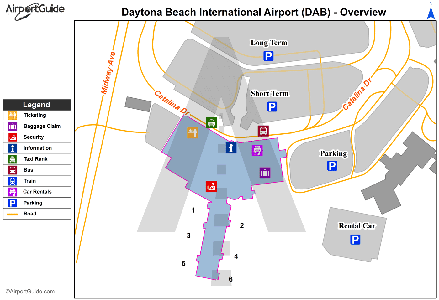
Maps & Diagrams
DAB Sectional
Flight Planning
at skyvector.com
at skyvector.com
 Diagram")