Location
Latitude: |
29-04-01.3000N (29.067028) |
Longitude: |
081-17-01.5000W (-81.28375) |
Elevation: |
79.1 feet MSL (24 m MSL) |
Magnetic Variation: |
6.9 W (as of April 2024 from WMM2020 model) |
Time Zone: |
UTC -5.0 (Standard Time) UTC -4.0 (Daylight Savings Time) |
From City: |
03 N.M. NE of Deland, Florida |
Found On: |
Jacksonville Chart |
FAA Region: |
ASO |
Contacts
Manager: |
Publicly owned: |
| JOHN EIFF 1000 FLIGHTLINE BLVD DELAND, FL 32724 386-626-7240 |
CITY OF DELAND 120 S FLORIDA AVE DELAND, FL 32720 386-626-7107 |
Operations
Airport Status: |
Operational |
Facility Use: |
Public |
Type: |
Airport |
Activation Date: |
04/1940 |
Control tower: |
No |
Attendance (Months/Days/Hours): |
Months/Days/Hours ALL/ALL/0800-1800 |
Boundary ARTCC: |
ZJX (Jacksonville) |
Responsible ARTCC: |
ZJX (Jacksonville) |
Lighting Schedule: |
SEE RMK |
Segmented Circle Indicator: |
Yes, Lighted |
Traffic Pattern Altitude (MSL): |
1079 feet (329 m) |
NOTAMs Facility: |
PIE |
NOTAM-D Service: |
Yes |
International Airport of Entry: |
No |
Customs Landing Rights: |
No |
Military Landing Rights: |
Yes |
Civil/Military Joint Use: |
No |
Based Aircraft
| Single Engine: | 124 |
| Multi Engine: | 16 |
| Jet Engine: | 4 |
| GA Helicopters: | 6 |
Annual Operations (as of 08/14/2018)
| Total Operations: | 117460 | |
| Air Taxi: | 400 | 0.3% |
| GA Local: | 35238 | 30.0% |
| GA Itinerant: | 81772 | 69.6% |
| Military Aircraft: | 50 | 0.0% |
Communications
| CTAF: | 123.075 |
| Unicom: | 123.075 |
| Approach: | DAYTONA |
| Departure: | DAYTONA |
| AWOS-3: | 119.575 (386-740-5811) |
Fixed Based Operators (FBOs) & Fuel
(Click on a business for detail)
Please help us keep this information up to date. This is a FREE SERVICE just like everything else on Airport Guide! If you see that a business needs to be added, modified, or deleted please fill out our Update Form.
To add, modify, or delete a business click here.
Please help us keep this information up to date. This is a FREE SERVICE just like everything else on Airport Guide! If you see that a business needs to be added, modified, or deleted please fill out our Update Form.
Area Code: 904 |
| Business Name | Frequency | Phone | Fuel Grade |
|---|---|---|---|
| Aero Masters
Update FBO info |
Unicom 122.8 | 736-7333 | 100LL, Jet A |
| Center for Aviation Training at Embry Riddle CATER
Update FBO info |
740-3311 | 100LL, Jet A |
Flight Service Stations
| Primary | Alternate | |
| FSS on Field: | N | |
| FSS Name (ID): | Saint Petersburg(PIE) | |
| Frequency: | ||
| Toll Free Phone: | 1-800-WX-BRIEF |
Instrument Procedures / Charts
FAA Terminal Procedures valid from 0901Z 03/21/24 to 0901Z 04/18/24.
There are various types of charts available for an airport. They are listed in the Page Type column. Here is a legend for those types:
APD - Airport Diagram
DP - Departure Procedure Charts
HOT - Hot Spots
IAP - Instrument Approach Procedure Charts
MIN - Minimums
STAR - Standard Terminal Arrival Charts
| Page Type | Page Name | Volume | Action Since Last Cycle |
|---|---|---|---|
| IAP | RNAV (GPS) RWY 05 | SE-3 | |
| IAP | RNAV (GPS) RWY 12 | SE-3 | |
| IAP | RNAV (GPS) RWY 23 | SE-3 | |
| IAP | RNAV (GPS) RWY 30 | SE-3 | |
| MIN | ALTERNATE MINIMUMS | SE-3 | |
| MIN | TAKEOFF MINIMUMS | SE-3 | |
| STAR | TTHOR THREE (RNAV) | SE-3 | |
| STAR | TTHOR THREE (RNAV)[DELIMITER] CONT.1 | SE-3 |
Terminal Procedures are only available for airports in several countries with more being added all the time. If you are looking for a specific country's charts, please send an email to support(at)airportguide.com stating the country name. This will be used to prioritize the implementation.
Navigation Aids (Navaids) near KDED
| Dist (NM) | ID | Morse Code | Name | Type | Freq | True Hdg | Mag Hdg |
|---|---|---|---|---|---|---|---|
| 0.5 | DED | _ . . . _ . . | Deland/Dcmsnd | NDB | 201 | 86 | 93 |
| 13.8 | DAB | _ . . . _ _ . . . | Daytona Beach | VOT | 111.00 | 60 | 67 |
| 16.8 | OMN | _ _ _ _ _ _ . | Ormond Beach | VORTAC | 112.60 | 32 | 39 |
| 17.1 | SFB | . . . . . _ . _ . . . | Sanford | NDB | 408 | 172 | 179 |
| 18.0 | EVB | . . . . _ _ . . . | New Smyrna Beach | NDB | 417 | 92 | 99 |
| 31.3 | LEE | . _ . . . . | Leesburg | NDB | 335 | 241 | 248 |
| 31.6 | ORL | _ _ _ . _ . . _ . . | Orlando | VORTAC | 112.20 | 184 | 191 |
| 34.5 | OR | _ _ _ . _ . | Herny | NDB | 221 | 193 | 200 |
| 42.1 | TVV | _ . . . _ . . . _ | Space Center Executive | NDB | 237 | 142 | 149 |
| 44.8 | IAK | . . . _ _ . _ | Palatka | NDB | 243 | 321 | 328 |
| 49.8 | OCF | _ _ _ _ . _ . . . _ . | Ocala | VORTAC | 113.70 | 277 | 284 |
| 53.4 | SGJ | . . . _ _ . . _ _ _ | St Augustine | VOR-DME | 109.40 | 357 | 364 |
| 57.4 | RYD | . _ . _ . _ _ _ . . | Reynolds | NDB | 338 | 340 | 347 |
| 58.9 | GN | _ _ . _ . | Wynds | NDB | 269 | 308 | 315 |
| 61.1 | COF | _ . _ . _ _ _ . . _ . | Patrick | TACAN | 115.00 | 144 | 151 |
| 63.9 | GNV | _ _ . _ . . . . _ | Gators | VORTAC | 116.20 | 306 | 313 |
| 65.7 | SQT | . . . _ _ . _ _ | Satellite | NDB | 257 | 151 | 158 |
| 67.1 | MLB | _ _ . _ . . _ . . . | Melbourne | VOR-DME | 115.85 | 149 | 156 |
| 68.2 | RHZ | . _ . . . . . _ _ . . | Zephyrhills | NDB | 253 | 222 | 229 |
| 73.0 | NIP | _ . . . . _ _ . | Jacksonville | TACAN | 108.20 | 343 | 350 |
Nearby Airports with Fuel
Notices to Airmen (NOTAMS)
Remarks
| A110*G | THIS AIRPORT HAS BEEN SURVEYED BY THE NATIONAL GEODETIC SURVEY. |
| A110-10 | UNLIGTD OBSTNS IN THE APCH TO RWY 05 DUE TO TREES 51 FT TALL 1455 FT BFR AER. |
| A110-2 | TOUCH & GO OPNS PROHIBITED IF THERE ARE 3 OR MORE ACFT IN THE TFC PATTERN. |
| A110-3 | NOISE ABATEMENT PROCEDURES IN EFFECT, CALL AMGR (386) 740-6955. |
| A110-4 | EXTSV PARACHUTE & FLT TRNG OPNS. AVOID OVER FLYING ARPT DURG PARACHUTE OPNS. |
| A110-5 | NOISE SENSITIVE ARPT. AVOID OVER FLT OF RESIDENTIAL AREA S OF ARPT; AVOID WIDE DOWNWIND RY 23. JET ACFT USE NBAA NOISE ABATEMENT PROCEDURES. |
| A110-6 | CALM WIND RY 05. |
| A110-7 | LMTD SIGHT DISTANCES ALL RYS. |
| A110-8 | CTC UNICOM FOR TIE DOWN INFO. |
| A110-9 | FOR CD OR TO CNL IFR CTC DAYTONA APCH AT 386-226-3939. |
| A14 | ARPT PHYS ADS: 1000 FLIGHTLINE BLVD. |
| A70-FUEL-10 | 0LL SELF SERVE 100LL AVBL 24 HRS WITH CREDIT CARD. |
| A81-APT | ACTVT REIL RWY 12 & 30; PAPI RWY 30; MIRL RWY 05/23, HIRL RWY 12/30 - CTAF. PAPI RWY 05, 12, & 23 OPER CONSLY. |
Runways
Runway Summary
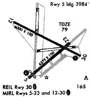
| Runways: | 05/23 12/30 |
| Longest Runway: | 12/30 is 6001 ft (1829 m) long |
| Runways with an Instrument Approach: |
KDED Airport Runway Details
| Runway 05/23 | 4301 ft x 75 ft (1311 m x 23 m) | |
| Runway Length Source: | NGS as of 06/23/2005 | |
| Surface: | Asphalt - Fair condition - No special surface treatment | |
| Runway Pavement Class: | 14 /F/B/Y/T | |
| Runway Edge Lights: | Medium Intensity | |
Runway Weight Bearing Capacity (in thousands of pounds) |
||
| Dual Wheel Landing Gear: | 40.0 | |
Runway 05 |
Runway 23 |
|
Elevation: |
78.3 | 67.9 |
Latitude: |
29-03-39.0823N | 29-04-07.1661N |
Longitude: |
081-17-17.2247W | 081-16-40.7904W |
|
Runway True Alignment: |
048 | 228 |
Glide Path Angle: |
3.0 degrees | 3.0 degrees |
Traffic Pattern: |
Left | Left |
Runway Markings Type: |
Nonprecision Instrument | Nonprecision Instrument |
Runway Markings Condition: |
Fair | Fair |
Object at End: |
TREES | TREES |
Object Height: |
50 | 54 |
Distance from End: |
1455 | 2055 |
Object Centerline Offset: |
230 ft. left of centerline | 200 ft. left of centerline |
Visual Glide Slope Indicators: |
2-Light PAPI On Left Side Of Runway | 2-Light PAPI On Left Side Of Runway |
Threshold Crossing Height: |
52 | 67 |
| Runway 12/30 | 6001 ft x 100 ft (1829 m x 30 m) | |
| Runway Length Source: | NGS as of 06/23/2005 | |
| Surface: | Asphalt - Fair condition - No special surface treatment | |
| Runway Pavement Class: | 35 /F/B/X/T | |
| Runway Edge Lights: | High Intensity | |
Runway Weight Bearing Capacity (in thousands of pounds) |
||
| Dual Wheel Landing Gear: | 60.0 | |
Runway 12 |
Runway 30 |
|
Elevation: |
73.7 | 70.1 |
Latitude: |
29-04-20.6678N | 29-03-53.6965N |
Longitude: |
081-17-33.4583W | 081-16-33.2092W |
|
Runway True Alignment: |
117 | 297 |
Glide Path Angle: |
3.0 degrees | 3.0 degrees |
Traffic Pattern: |
Left | Left |
Runway Markings Type: |
Nonprecision Instrument | Nonprecision Instrument |
Runway Markings Condition: |
Fair | Fair |
Object at End: |
TREES | TREES |
Object Height: |
26 | 66 |
Distance from End: |
1105 | 2220 |
Object Centerline Offset: |
230 ft. left of centerline | 200 ft. left of centerline |
Visual Glide Slope Indicators: |
2-Light PAPI On Left Side Of Runway | 4-Light PAPI On Left Side Of Runway |
REIL: |
Yes | Yes |
Threshold Crossing Height: |
51 | 54 |
Services
Airframe Repair: |
Major |
Powerplant Repair: |
Major |
Bottled Oxygen: |
None |
Bulk Oxygen: |
None |
Fuel Available: |
100LL, Jet A |
Landing Fees: |
No |
Parking: |
Tiedowns available |
Maps & Diagrams
KDED Sectional
Flight Planning
at skyvector.com
at skyvector.com