Location
Latitude: |
28-30-53.3000N (28.514806) |
Longitude: |
080-47-57.2000W (-80.799222) |
Elevation: |
33.8 feet MSL (10 m MSL) |
Magnetic Variation: |
7.2 W (as of April 2024 from WMM2020 model) |
Time Zone: |
UTC -5.0 (Standard Time) UTC -4.0 (Daylight Savings Time) |
From City: |
05 N.M. S of Titusville, Florida |
Found On: |
Jacksonville Chart |
FAA Region: |
ASO |
Contacts
Manager: |
Publicly owned: |
| KEVIN DAUGHERTY, AAE 355 GOLDEN KNIGHTS BLVD TITUSVILLE, FL 32780 321-267-8780 |
TITUSVILLE COCOA ARPT AUTH 51 BRISTOW WAY TITUSVILLE, FL 32780 321-267-8780 |
Operations
Airport Status: |
Operational |
Facility Use: |
Public |
Type: |
Airport |
Activation Date: |
10/1944 |
Control tower: |
Yes |
Attendance (Months/Days/Hours): |
Months/Days/Hours ALL/ALL/0700-2100 |
Boundary ARTCC: |
ZMA (Miami) |
Responsible ARTCC: |
ZJX (Jacksonville) |
Lighting Schedule: |
SEE RMK |
Segmented Circle Indicator: |
No |
Traffic Pattern Altitude (MSL): |
1034 feet (315 m) |
NOTAMs Facility: |
TIX |
NOTAM-D Service: |
Yes |
International Airport of Entry: |
No |
Customs Landing Rights: |
No |
Military Landing Rights: |
Yes |
Civil/Military Joint Use: |
No |
Aircraft Rescue and Firefighting: |
Class IV ARFF Index: A Air Carrier Service: Not Scheduled Certification Date: 10/1985 |
Based Aircraft
| Single Engine: | 82 |
| Multi Engine: | 11 |
| Jet Engine: | 1 |
| GA Helicopters: | 16 |
Annual Operations (as of 12/31/2023)
| Total Operations: | 101859 | |
| Air Taxi: | 448 | 0.4% |
| GA Local: | 63493 | 62.3% |
| GA Itinerant: | 37845 | 37.2% |
| Military Aircraft: | 73 | 0.1% |
Communications
| CTAF: | 118.900 |
| Unicom: | 122.950 |
| Tower: | SPACE COAST 118.9 Hrs: 0700-2100 |
| Ground: | 121.85 |
| Approach: | ORLANDO |
| Departure: | ORLANDO |
| ATIS: | 120.625 Hrs: 24 HRS. |
| AWOS-3PT: | 120.625 (321-567-6090) |
| EMERG: | 121.5 |
| EMERG: | 243.0 |
Fixed Based Operators (FBOs) & Fuel
(Click on a business for detail)
Please help us keep this information up to date. This is a FREE SERVICE just like everything else on Airport Guide! If you see that a business needs to be added, modified, or deleted please fill out our Update Form.
To add, modify, or delete a business click here.
Please help us keep this information up to date. This is a FREE SERVICE just like everything else on Airport Guide! If you see that a business needs to be added, modified, or deleted please fill out our Update Form.
Area Code: 321 |
| Business Name | Frequency | Phone | Fuel Grade |
|---|---|---|---|
| Discovery Aviation Center
Update FBO info |
Unicom 122.95 | 267-6043 | 100LL, Jet A |
| Gateway Aviation
Update FBO info |
Unicom 122.95 | 267-1345 | 100LL, Jet A |
| Willie Air Tours
Update FBO info |
Flight Service Stations
| Primary | Alternate | |
| FSS on Field: | N | |
| FSS Name (ID): | Saint Petersburg(PIE) | |
| Frequency: | ||
| Toll Free Phone: | 1-800-WX-BRIEF |
Instrument Procedures / Charts
FAA Terminal Procedures valid from 0901Z 03/21/24 to 0901Z 04/18/24.
There are various types of charts available for an airport. They are listed in the Page Type column. Here is a legend for those types:
APD - Airport Diagram
DP - Departure Procedure Charts
HOT - Hot Spots
IAP - Instrument Approach Procedure Charts
MIN - Minimums
STAR - Standard Terminal Arrival Charts
| Page Type | Page Name | Volume | Action Since Last Cycle |
|---|---|---|---|
| APD | AIRPORT DIAGRAM | SE-3 | |
| HOT | HOT SPOT | SE-3 | |
| IAP | ILS OR LOC RWY 36 | SE-3 | |
| IAP | RNAV (GPS) RWY 09 | SE-3 | |
| IAP | RNAV (GPS) RWY 36 | SE-3 | |
| IAP | RNAV (GPS) Y RWY 18 | SE-3 | |
| IAP | RNAV (GPS) Z RWY 18 | SE-3 | |
| LAH | LAHSO | SE-3 | |
| MIN | ALTERNATE MINIMUMS | SE-3 | |
| MIN | TAKEOFF MINIMUMS | SE-3 | |
| STAR | BITHO SEVEN | SE-3 | Changed |
| STAR | GOOFY SEVEN | SE-3 | Changed |
| STAR | MINEE FIVE | SE-3 | Changed |
| STAR | MINEE FIVE[DELIMITER] CONT.1 | SE-3 |
Terminal Procedures are only available for airports in several countries with more being added all the time. If you are looking for a specific country's charts, please send an email to support(at)airportguide.com stating the country name. This will be used to prioritize the implementation.
Navigation Aids (Navaids) near TIX
| Dist (NM) | ID | Morse Code | Name | Type | Freq | True Hdg | Mag Hdg |
|---|---|---|---|---|---|---|---|
| 0.3 | TVV | _ . . . _ . . . _ | Space Center Executive | NDB | 237 | 114 | 121 |
| 19.3 | COF | _ . _ . _ _ _ . . _ . | Patrick | TACAN | 115.00 | 149 | 156 |
| 25.5 | SQT | . . . _ _ . _ _ | Satellite | NDB | 257 | 168 | 175 |
| 26.1 | MLB | _ _ . _ . . _ . . . | Melbourne | VOR-DME | 115.85 | 160 | 167 |
| 28.3 | ORL | _ _ _ . _ . . _ . . | Orlando | VORTAC | 112.20 | 273 | 280 |
| 28.4 | SFB | . . . . . _ . _ . . . | Sanford | NDB | 408 | 304 | 311 |
| 33.2 | EVB | . . . . _ _ . . . | New Smyrna Beach | NDB | 417 | 347 | 354 |
| 33.5 | OR | _ _ _ . _ . | Herny | NDB | 221 | 269 | 276 |
| 41.5 | DED | _ . . . _ . . | Deland/Dcmsnd | NDB | 201 | 323 | 330 |
| 42.2 | DAB | _ . . . _ _ . . . | Daytona Beach | VOT | 111.00 | 341 | 348 |
| 50.1 | OMN | _ _ _ _ _ _ . | Ormond Beach | VORTAC | 112.60 | 340 | 347 |
| 52.8 | TRV | _ . _ . . . . _ | Treasure | VORTAC | 117.30 | 161 | 168 |
| 56.1 | LEE | . _ . . . . | Leesburg | NDB | 335 | 289 | 296 |
| 65.7 | FPR | . . _ . . _ _ . . _ . | Fort Pierce | NDB | 275 | 159 | 166 |
| 71.6 | LAL | . _ . . . _ . _ . . | Lakeland | VORTAC | 116.00 | 243 | 250 |
| 73.7 | RHZ | . _ . . . . . _ _ . . | Zephyrhills | NDB | 253 | 256 | 263 |
| 84.9 | OCF | _ _ _ _ . _ . . . _ . | Ocala | VORTAC | 113.70 | 298 | 305 |
| 86.5 | IAK | . . . _ _ . _ | Palatka | NDB | 243 | 322 | 329 |
| 90.9 | SGJ | . . . _ _ . . _ _ _ | St Augustine | VOR-DME | 109.40 | 342 | 349 |
| 94.7 | TP | _ . _ _ . | Cosme | NDB | 368 | 254 | 261 |
Nearby Airports with Fuel
Notices to Airmen (NOTAMS)
Remarks
| A110-2 | IN MINIMUM VIS CONDS BRIGHT LGTS IN PARKING LOT 1/4 MILE E OF RY 18 MAY BE MISTAKEN FOR RY LGTS. |
| A110-4 | ATCT UNABLE AIR TRAFFIC SVCS ON THESE AREAS OF NON-VISIBILITY: SOUTHWEST PORTIONS OF TAXILANES 'D' AND 'E'. |
| A110-5 | FOR CD OR TO CNL IFR IF UNA TO CTC ON FSS FREQ, CTC ORLANDO APCH AT 407-852-7500. |
| A26 | CLSD TO ACR OPNS WITH MORE THAN 30 PAX SEATS EXC PPR CALL AMGR 321-267-8780. INDEX A ARFF EQUIPMENT AVAILABLE MONDAY-FRIDAY 0700-1600 L OR UPON REQ. CONTACT ARPT FIRE CHIEF TO COORD 321-289-5393. |
| A30-18/36 | RWY 18/36 CLSD TO UNSKED AIR CARRIER OPS MORE THAN 30 PAX SEATS. |
| A58-18 | TREES 425 FT LEFT & RIGHT OF CNTRLN FIRST 1500 FT OF RWY 18. |
| A70-FUEL-10 | 0LL FOR FUEL AFT HRS CALL 321-267-8355 OR 321-603-6380. |
| A81-APT | WHEN ATCT CLSD ACTVT MALSR RWY 36; REIL RWYS 9, 18, & 27; PAPI RWYS 09, 27, 18, & 36; MIRL RWY 09/27; HIRL RWY 18/36 - CTAF. |
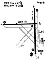
Runways
Runway Summary
| Runways: | 09/27 18/36 |
| Longest Runway: | 18/36 is 7319 ft (2231 m) long |
| Runways with an Instrument Approach: | 36 |
TIX Airport Runway Details
| Runway 09/27 | 5000 ft x 100 ft (1524 m x 30 m) | |
| Runway Length Source: | 3RD PARTY SURVEY as of 06/22/2015 | |
| Surface: | Asphalt - Excellent condition - No special surface treatment | |
| Runway Pavement Class: | 41 /F/B/W/T | |
| Runway Edge Lights: | Medium Intensity | |
Runway Weight Bearing Capacity (in thousands of pounds) |
||
| Single Wheel Landing Gear: | 50.0 | |
| Dual Wheel Landing Gear: | 80.0 | |
Runway 09 |
Runway 27 |
|
Elevation: |
32.3 | 31.2 |
Latitude: |
28-30-54.1867N | 28-30-54.9377N |
Longitude: |
080-48-38.4135W | 080-47-42.3768W |
|
Runway True Alignment: |
089 | 269 |
Glide Path Angle: |
3.0 degrees | 3.0 degrees |
Traffic Pattern: |
Left | Left |
Runway Markings Type: |
Nonprecision Instrument | Nonprecision Instrument |
Runway Markings Condition: |
Fair | Fair |
Object at End: |
TREES | TREES |
Object Height: |
29 | 53 |
Distance from End: |
1215 | 1260 |
Object Centerline Offset: |
240 ft. left of centerline | 265 ft. left of centerline |
Visual Glide Slope Indicators: |
4-Light PAPI On Left Side Of Runway | 4-Light PAPI On Left Side Of Runway |
REIL: |
Yes | Yes |
Threshold Crossing Height: |
42 | 45 |
Declared Distances |
||
Take Off Run Avbl. (TORA): |
5000 | 5000 |
Take Off Distance Avbl. (TODA): |
5000 | 5000 |
Actual Stop Dist. Avbl. (ASDA): |
5000 | 5000 |
Landing Dist. Avbl. (LDA): |
5000 | 5000 |
| Runway 18/36 | 7319 ft x 150 ft (2231 m x 46 m) | |
| Runway Length Source: | 3RD PARTY SURVEY as of 06/22/2015 | |
| Surface: | Asphalt - Excellent condition - Saw-cut or plastic grooved | |
| Runway Pavement Class: | 41 /F/A/W/T | |
| Runway Edge Lights: | High Intensity | |
Runway Weight Bearing Capacity (in thousands of pounds) |
||
| Single Wheel Landing Gear: | 80.0 | |
| Dual Wheel Landing Gear: | 110.0 | |
| Dual Tandem Wheel Landing Gear: | 190.0 | |
Runway 18 |
Runway 36 |
|
Elevation: |
29.6 | 33.6 |
Latitude: |
28-31-28.6153N | 28-30-16.1606N |
Longitude: |
080-47-48.8424W | 080-47-47.5921W |
|
Runway True Alignment: |
179 | 359 |
ILS Type: |
ILS | |
Glide Path Angle: |
3.0 degrees | 3.0 degrees |
Traffic Pattern: |
Left | Left |
Runway Markings Type: |
Nonprecision Instrument | Precision Instrument |
Runway Markings Condition: |
Fair | Fair |
Object at End: |
TREES | TREES |
Object Height: |
52 | 24 |
Distance from End: |
1465 | 1155 |
Object Centerline Offset: |
240 ft. left of centerline | 265 ft. left of centerline |
Visual Glide Slope Indicators: |
4-Light PAPI On Left Side Of Runway | 4-Light PAPI On Left Side Of Runway |
Approach Light System: |
1,400 Foot Medium Intensity Approach Lighting System With Runway Alignment Indicator Lights | |
REIL: |
Yes | No |
Threshold Crossing Height: |
44 | 56 |
Threshold Elevation: |
29.7 | |
Displaced Threshold: |
322 | |
Threshold Latitude: |
28-31-25.4286N | |
Threshold Longitude: |
080-47-48.7922W | |
Declared Distances |
||
Take Off Run Avbl. (TORA): |
7319 | 7319 |
Take Off Distance Avbl. (TODA): |
7319 | 7319 |
Actual Stop Dist. Avbl. (ASDA): |
7249 | 7244 |
Landing Dist. Avbl. (LDA): |
6930 | 7244 |
Services
Airframe Repair: |
None |
Powerplant Repair: |
None |
Bottled Oxygen: |
None |
Bulk Oxygen: |
None |
Fuel Available: |
100LL |
Landing Fees: |
No |
Parking: |
Hangars available |
Maps & Diagrams
TIX Sectional
Flight Planning
at skyvector.com
at skyvector.com