Location
Latitude: |
45-46-38.0488N (45.777236) |
Longitude: |
111-09-00.9370W (-111.15026) |
Elevation: |
4473.4 feet MSL (1363 m MSL) |
Magnetic Variation: |
11.4 E (as of April 2024 from WMM2020 model) |
Time Zone: |
UTC -7.0 (Standard Time) UTC -6.0 (Daylight Savings Time) |
From City: |
07 N.M. NW of Bozeman, Montana |
Found On: |
Great Falls Chart |
FAA Region: |
ANM |
Contacts
Manager: |
Publicly owned: |
| BRIAN SPRENGER 850 GALLATIN FIELD RD, SUITE #6 BELGRADE, MT 59714 406-388-6632 |
GALLATIN AIRPORT AUTHORITY 850 GALLATIN FIELD SUITE 6 BELGRADE, MT 59714 406-388-6632 |
Operations
Airport Status: |
Operational |
Facility Use: |
Public |
Type: |
Airport |
Activation Date: |
07/1942 |
Control tower: |
Yes |
Attendance (Months/Days/Hours): |
Months/Days/Hours ALL/ALL/0430-0100 |
Boundary ARTCC: |
ZLC (Salt Lake City) |
Responsible ARTCC: |
ZLC (Salt Lake City) |
Lighting Schedule: |
SEE RMK |
Segmented Circle Indicator: |
No |
Traffic Pattern Altitude (MSL): |
5473 feet (1668 m) |
NOTAMs Facility: |
BZN |
NOTAM-D Service: |
Yes |
International Airport of Entry: |
No |
Customs Landing Rights: |
No |
Military Landing Rights: |
Yes |
Civil/Military Joint Use: |
No |
Aircraft Rescue and Firefighting: |
Class I ARFF Index: C Air Carrier Service: Scheduled Certification Date: 05/1973 |
Based Aircraft
| Single Engine: | 262 |
| Multi Engine: | 37 |
| Jet Engine: | 74 |
| GA Helicopters: | 25 |
| Gliders: | 10 |
Annual Operations (as of 01/01/2022)
| Total Operations: | 116055 | |
| Commercial: | 23061 | 19.9% |
| Air Taxi: | 11859 | 10.2% |
| GA Local: | 34775 | 30.0% |
| GA Itinerant: | 45763 | 39.4% |
| Military Aircraft: | 597 | 0.5% |
Communications
| CTAF: | 118.200 |
| Unicom: | 122.950 |
| Tower: | BOZEMAN 118.2 Hrs: 0600-0000 |
| Ground: | 121.8 |
| Approach: | BIG SKY 118.975 118.975 SALT LAKE ARTCC |
| Departure: | BIG SKY 118.975 118.975 SALT LAKE ARTCC |
| ATIS: | 135.425 Hrs: 24 |
| ASOS: | (406-388-4882) |
- COMMUNICATIONS PRVDD BY GREAT FALLS RADIO ON FREQ 122.5 (BOZEMAN RCO).
- APCH/DEP CTL SVC PRVDD BY BIG SKY APCH CTL (BOI) ON FREQ 118.975/226.675 FM 0600-0015 LCL. SALT LAKE ARTCC (ZLC) PRVDD'S APCH/DEP SVC ON 118.975/226.675 ( BOZEMAN A RCAG) FM 0015-0600 LCL.
Fixed Based Operators (FBOs) & Fuel
(Click on a business for detail)
Please help us keep this information up to date. This is a FREE SERVICE just like everything else on Airport Guide! If you see that a business needs to be added, modified, or deleted please fill out our Update Form.
To add, modify, or delete a business click here.
Please help us keep this information up to date. This is a FREE SERVICE just like everything else on Airport Guide! If you see that a business needs to be added, modified, or deleted please fill out our Update Form.
Area Code: 406 |
| Business Name | Frequency | Phone | Fuel Grade |
|---|---|---|---|
| Arlin's Aircraft Service, Inc.
Update FBO info |
Unicom 123.50 | 388-1351 | 100LL, Jet A |
| Signature Flight Support
Update FBO info |
Unicom: 122.95, Arinc: 123.3 | +1 406 388 4152 | |
| Sunbird Aviation
Website Update FBO info |
Unicom 123.3 | 388-4152 | |
| Yellowstone Jet Center, LLC
Website Update FBO info |
123.300 | 406-388-4152 / 800-700-5381 | 100LL, Jet A |

|
 Exxon |
100LL - 2.55 USD per gallon on 2/20/02 |
Trucks CALL FOR DISCOUNT PRICING/ 24/7 ON CALL FOR FUEL AND MAINTENANCE, HEATED HANGAR TO BBJ. |
|
|
Exxon |
Jet A - 2.19 USD per gallon on 2/20/02 |
Trucks CALL FOR DISCOUNT PRICING/ 24/7 ON CALL FOR FUEL AND MAINTENANCE, HEATED HANGAR TO BBJ. |
Flight Service Stations
| Primary | Alternate | |
| FSS on Field: | N | |
| FSS Name (ID): | Great Falls(GTF) | |
| Frequency: | ||
| Toll Free Phone: | 1-800-WX-BRIEF |
Instrument Procedures / Charts
FAA Terminal Procedures valid from 0901Z 03/21/24 to 0901Z 04/18/24.
There are various types of charts available for an airport. They are listed in the Page Type column. Here is a legend for those types:
APD - Airport Diagram
DP - Departure Procedure Charts
HOT - Hot Spots
IAP - Instrument Approach Procedure Charts
MIN - Minimums
STAR - Standard Terminal Arrival Charts
| Page Type | Page Name | Volume | Action Since Last Cycle |
|---|---|---|---|
| APD | AIRPORT DIAGRAM | NW-1 | |
| DP | BOBKT FOUR (RNAV) | NW-1 | |
| DP | TEERX FOUR (RNAV) | NW-1 | |
| DP | WHITEHALL FIVE | NW-1 | |
| HOT | HOT SPOT | NW-1 | |
| IAP | ILS OR LOC RWY 12 | NW-1 | |
| IAP | RNAV (GPS) Y RWY 12 | NW-1 | |
| IAP | RNAV (GPS) Y RWY 30 | NW-1 | |
| IAP | RNAV (GPS)-A | NW-1 | |
| IAP | RNAV (RNP) RWY 30 | NW-1 | |
| IAP | RNAV (RNP) Z RWY 12 | NW-1 | |
| IAP | VOR RWY 12 | NW-1 | |
| LAH | LAHSO | NW-1 | |
| MIN | ALTERNATE MINIMUMS | NW-1 | |
| MIN | TAKEOFF MINIMUMS | NW-1 | |
| ODP | BOZEMAN SIX (OBSTACLE) | NW-1 |
Terminal Procedures are only available for airports in several countries with more being added all the time. If you are looking for a specific country's charts, please send an email to support(at)airportguide.com stating the country name. This will be used to prioritize the implementation.
Navigation Aids (Navaids) near BZN
| Dist (NM) | ID | Morse Code | Name | Type | Freq | True Hdg | Mag Hdg |
|---|---|---|---|---|---|---|---|
| 0.5 | BZN | _ . . . _ _ . . _ . | Bozeman | VOR-DME | 112.40 | 331 | 320 |
| 8.0 | BZ | _ . . . _ _ . . | Manni | NDB | 266 | 315 | 304 |
| 30.0 | LVM | . _ . . . . . _ _ _ | Livingston | VOR-DME | 116.10 | 98 | 87 |
| 37.2 | EKS | . _ . _ . . . | Ennis | NDB | 286 | 214 | 203 |
| 42.9 | HIA | . . . . . . . _ | Whitehall | VOR-DME | 113.70 | 277 | 265 |
| 53.8 | HAU | . . . . . _ . . _ | Hauser | NDB | 386 | 332 | 320 |
| 59.5 | CVP | _ . _ . . . . _ . _ _ . | Capitol | NDB | 335 | 326 | 314 |
| 59.9 | HLN | . . . . . _ . . _ . | Helena | VORTAC | 117.70 | 326 | 314 |
| 65.3 | ESY | . . . . _ . _ _ | Yellowstone | NDB | 338 | 178 | 167 |
| 66.1 | WYS | . _ _ _ . _ _ . . . | West Yellowstone | DME | 114.85 | 179 | 168 |
| 66.7 | DLN | _ . . . _ . . _ . | Dillon | VOR-DME | 113.00 | 242 | 230 |
| 67.5 | HWQ | . . . . . _ _ _ _ . _ | Harlowton | NDB | 242 | 53 | 42 |
| 68.4 | CPN | _ . _ . . _ _ . _ . | Coppertown | VOR-DME | 116.05 | 283 | 271 |
| 72.1 | LO | . _ . . _ _ _ | Targy | NDB | 415 | 181 | 170 |
| 95.8 | ITU | . . _ . . _ | Truly | NDB | 371 | 354 | 342 |
| 99.7 | LWT | . _ . . . _ _ _ | Lewistown | VOR-DME | 115.45 | 39 | 28 |
Nearby Airports with Fuel
Notices to Airmen (NOTAMS)
Remarks
| A110-10 | RWY 12 IS NORMALLY USED FOR ARRIVALS/DEPARTURES WHEN THE WIND SPEED IS LESS THAN 10 KNOTS. IF AIRCRAFT IS UNABLE TO USE RWY 12, OTHER RWYS MAY BE USED BUT DELAYS MAY OCCUR. |
| A110-11 | LDG AREA 11G/29G TURF LCTD 240 FT S OF RWY 11/29. AVBL WHEN DRY WITH ATC APVL. MKD WITH W CONES. |
| A110-12 | MIGRATORY BIRDS INVOF ARPT. |
| A110-13 | HVY STUDENT TRNG ACTVTY WI 15 MIS OF AP. |
| A110-14 | FOR CD IF UNA TO CTC ON FSS FREQ, CTC SALT LAKE ARTCC AT 801-320-2568. |
| A110-4 | TKOF RWY 3 PROHIBITED UNTIL AFTER CFMG NO TFC USING RWY 12. |
| A110-5 | SNOW REMOVAL EQUIP MONITORS - CTAF. |
| A110-6 | GLIDER OPNS ON & INVOF ARPT. |
| A110-7 | RY 21 BTN RY 12/30 & TWY A AVBL FOR ACFT GREATER THAN 12,500 LBS DAY/VFR ONLY. |
| A110-9 | COLD TEMPERATURE AIRPORT. ALTITUDE CORRECTION REQUIRED AT OR BELOW -31C. |
| A14 | EMAIL BRIAN.SPRENGER@BOZEMANAIRPORT.COM |
| A24 | LDG FEE FOR ACFT OVR 8500 LBS. |
| A81-APT | WHEN ATCT CLSD ACTVT MALSR RWY 12; REIL RWY 30; HIRL RWY 12/30; MIRL RWY 11/29 - CTAF. PAPI RWY 12 & 30 OPR CONSLY. |
| E80 | US CUSTOMS USER FEE ARPT. |
| E80A | U.S. CUSTOMS AVBL 1600Z-2400Z THU-MON. |
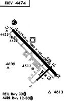
Runways
Runway Summary
| Runways: | 03/21 11/29 11G/29G 12/30 |
| Longest Runway: | 12/30 is 8994 ft (2741 m) long |
| Runways with an Instrument Approach: | 12 |
BZN Airport Runway Details
| Runway 03/21 | 2650 ft x 75 ft (808 m x 23 m) | |
| Runway Length Source: | 3RD PARTY SURVEY as of 05/04/2008 | |
| Surface: | Asphalt - Good condition - Saw-cut or plastic grooved | |
| Runway Pavement Class: | 90 /F/A/X/T | |
Runway Weight Bearing Capacity (in thousands of pounds) |
||
| Single Wheel Landing Gear: | 12.5 | |
Runway 03 |
Runway 21 |
|
Elevation: |
4473.4 | 4454.7 |
Latitude: |
45-46-07.8581N | 45-46-26.1007N |
Longitude: |
111-09-09.1891W | 111-08-42.4339W |
|
Runway True Alignment: |
046 | 226 |
Glide Path Angle: |
0.0 degrees | 0.0 degrees |
Traffic Pattern: |
Left | Left |
Runway Markings Type: |
Basic | Basic |
Runway Markings Condition: |
Good | Good |
Declared Distances |
||
Take Off Run Avbl. (TORA): |
2650 | 2650 |
Take Off Distance Avbl. (TODA): |
2650 | 2650 |
Actual Stop Dist. Avbl. (ASDA): |
2650 | 2650 |
Landing Dist. Avbl. (LDA): |
2650 | 2650 |
| Runway 11/29 | 5050 ft x 75 ft (1539 m x 23 m) | |
| Runway Length Source: | OWNER as of 10/26/2017 | |
| Surface: | Asphalt - Good condition - Saw-cut or plastic grooved | |
| Runway Pavement Class: | 61 /F/A/X/U | |
| Runway Edge Lights: | Medium Intensity | |
Runway Weight Bearing Capacity (in thousands of pounds) |
||
| Single Wheel Landing Gear: | 12.5 | |
Runway 11 |
Runway 29 |
|
Elevation: |
4441.8 | 4461.4 |
Latitude: |
45-46-53.3600N | 45-46-17.6400N |
Longitude: |
111-09-07.7500W | 111-08-18.0700W |
|
Runway True Alignment: |
136 | 316 |
Glide Path Angle: |
3.0 degrees | 3.0 degrees |
Runway Markings Type: |
Basic | Basic |
Runway Markings Condition: |
Good | Good |
Visual Glide Slope Indicators: |
4-Light PAPI On Left Side Of Runway | 4-Light PAPI On Left Side Of Runway |
Threshold Crossing Height: |
42 | 47 |
Declared Distances |
||
Take Off Run Avbl. (TORA): |
5050 | 5050 |
Take Off Distance Avbl. (TODA): |
5050 | 5050 |
Actual Stop Dist. Avbl. (ASDA): |
5050 | 5050 |
Landing Dist. Avbl. (LDA): |
5050 | 5050 |
| Runway 11G/29G | 2802 ft x 80 ft (854 m x 24 m) | |
| Runway Length Source: | OWNER as of 07/22/2019 | |
| Surface: | Asphalt - Good condition - No special surface treatment | |
Runway 11G |
Runway 29G |
|
Elevation: |
4444.2 | 4453.2 |
Latitude: |
45-46-49.1900N | 45-46-29.4000N |
Longitude: |
111-09-06.7200W | 111-08-39.1100W |
|
Runway True Alignment: |
136 | 316 |
Glide Path Angle: |
0.0 degrees | 0.0 degrees |
| Runway 12/30 | 8994 ft x 150 ft (2741 m x 46 m) | |
| Runway Length Source: | 3RD PARTY SURVEY as of 05/04/2008 | |
| Surface: | Asphalt - Good condition - Saw-cut or plastic grooved | |
| Runway Pavement Class: | 123/F/A/X/T | |
| Runway Edge Lights: | High Intensity | |
Runway Weight Bearing Capacity (in thousands of pounds) |
||
| Single Wheel Landing Gear: | 120.0 | |
| Dual Wheel Landing Gear: | 250.0 | |
| Dual Tandem Wheel Landing Gear: | 550.0 | |
| Dual Dual Tandem Wheel Landing Gear: | 1120.0 | |
Runway 12 |
Runway 30 |
|
Elevation: |
4424.9 | 4462.3 |
Latitude: |
45-47-17.1074N | 45-46-13.4918N |
Longitude: |
111-09-59.3342W | 111-08-30.8022W |
|
Runway True Alignment: |
136 | 316 |
ILS Type: |
ILS | |
Glide Path Angle: |
3.0 degrees | 3.0 degrees |
Traffic Pattern: |
Left | Left |
Runway Markings Type: |
Precision Instrument | Precision Instrument |
Runway Markings Condition: |
Good | Good |
Visual Glide Slope Indicators: |
4-Light PAPI On Left Side Of Runway | 4-Light PAPI On Left Side Of Runway |
Approach Light System: |
1,400 Foot Medium Intensity Approach Lighting System With Runway Alignment Indicator Lights | |
REIL: |
Yes | |
Threshold Crossing Height: |
53 | 45 |
Declared Distances |
||
Take Off Run Avbl. (TORA): |
8994 | 8994 |
Take Off Distance Avbl. (TODA): |
8994 | 8994 |
Actual Stop Dist. Avbl. (ASDA): |
8994 | 8994 |
Landing Dist. Avbl. (LDA): |
8994 | 8994 |
Services
Airframe Repair: |
None |
Powerplant Repair: |
None |
Bottled Oxygen: |
None |
Bulk Oxygen: |
None |
Fuel Available: |
100LL |
Landing Fees: |
No |
Parking: |
Hangars and tiedowns available |
Maps & Diagrams
BZN Sectional
Flight Planning
at skyvector.com
at skyvector.com