Location
Latitude: |
46-36-24.2000N (46.606722) |
Longitude: |
111-58-59.8000W (-111.983278) |
Elevation: |
3877.3 feet MSL (1182 m MSL) |
Magnetic Variation: |
11.9 E (as of April 2024 from WMM2020 model) |
Time Zone: |
UTC -7.0 (Standard Time) UTC -6.0 (Daylight Savings Time) |
From City: |
02 N.M. NE of Helena, Montana |
Found On: |
Great Falls Chart |
FAA Region: |
ANM |
Contacts
Manager: |
Publicly owned: |
| JEFF WADEKAMPER 2850 MERCER LOOP HELENA, MT 59602 406-442-2821 |
HELENA REG ARPT AUTH 2850 MERCER LOOP HELENA, MT 59602 406-442-2821 |
Operations
Airport Status: |
Operational |
Facility Use: |
Public |
Type: |
Airport |
Activation Date: |
04/1940 |
Control tower: |
Yes |
Attendance (Months/Days/Hours): |
Months/Days/Hours ALL/ALL/0500-0100 |
Boundary ARTCC: |
ZLC (Salt Lake City) |
Responsible ARTCC: |
ZLC (Salt Lake City) |
Lighting Schedule: |
SEE RMK |
Segmented Circle Indicator: |
Yes |
Traffic Pattern Altitude (MSL): |
4877 feet (1487 m) |
NOTAMs Facility: |
HLN |
NOTAM-D Service: |
Yes |
International Airport of Entry: |
No |
Customs Landing Rights: |
Yes |
Military Landing Rights: |
Yes |
Civil/Military Joint Use: |
No |
Aircraft Rescue and Firefighting: |
Class I ARFF Index: B Air Carrier Service: Scheduled Certification Date: 05/1973 |
Based Aircraft
| Single Engine: | 164 |
| Multi Engine: | 38 |
| Jet Engine: | 2 |
| GA Helicopters: | 29 |
| Military Aircraft: | 23 |
| Ultralights: | 5 |
Annual Operations (as of 12/31/2023)
| Total Operations: | 47547 | |
| Commercial: | 2651 | 5.6% |
| Air Taxi: | 2876 | 6.0% |
| GA Local: | 22362 | 47.0% |
| GA Itinerant: | 14633 | 30.8% |
| Military Aircraft: | 5025 | 10.6% |
Communications
| CTAF: | 118.300 |
| Unicom: | 122.950 |
| Tower: | HELENA 118.3 257.8 Hrs: 0600-2200 |
| Ground: | 121.9 |
| Approach: | HELENA 119.5 229.4 Hrs: 0600-2200 SALT LAKE ARTCC Hrs: 2200-0600 |
| Departure: | HELENA 119.5 229.4 Hrs: 0600-2200 SALT LAKE ARTCC Hrs: 2200-0600 |
| ATIS: | 120.4 Hrs: 24 |
| ASOS: | 120.4 (406-443-4317) |
| ARNG OPS: | 321.45 |
| ARNG OPS: | 40.65FM |
| EMERG: | 121.5 |
| ARNG OPS: | 126.2 |
| EMERG: | 243.0 |
- APCH/DEP CTL SVC PRVDD BY SALT LAKE ARTCC (ZLC) ON FREQS 133.4/285.4 (BUTTE RCAG) WHEN HELENA APCH CTL (HLN) CLSD.
Fixed Based Operators (FBOs) & Fuel
(Click on a business for detail)
Please help us keep this information up to date. This is a FREE SERVICE just like everything else on Airport Guide! If you see that a business needs to be added, modified, or deleted please fill out our Update Form.
To add, modify, or delete a business click here.
Please help us keep this information up to date. This is a FREE SERVICE just like everything else on Airport Guide! If you see that a business needs to be added, modified, or deleted please fill out our Update Form.
Area Code: 406 |
| Business Name | Frequency | Phone | Fuel Grade |
|---|---|---|---|
| Beck's U-Pump
Update FBO info |
443-6464 | 100LL | |
| Exec Air Montana, Inc.
Update FBO info |
Unicom 122.95 | 800-513-2190, 442-2190 | 100LL, Jet A |

|
 Exxon |
100LL - 6.05 USD per gallon on 6/24/14 |
Full Serve |
|
|
Exxon |
100LL - 6.05 USD per gallon on 6/24/14 |
Self Serve |
|
|
Exxon |
Jet A - 5.85 USD per gallon on 6/24/14 |
Full Serve |
| Helena Aircraft
Update FBO info |
442-8360 | ||
| Vetter Aviation
Update FBO info |
Unicom 122.95 | 443-0066 | 100LL |
| West Air
Update FBO info |
Unicom 122.95 | 443-4543, 439-3343, after hours call 439-4204 | 100LL, Jet A |
Flight Service Stations
| Primary | Alternate | |
| FSS on Field: | N | |
| FSS Name (ID): | Great Falls(GTF) | |
| Frequency: | ||
| Toll Free Phone: | 1-800-WX-BRIEF |
Instrument Procedures / Charts
FAA Terminal Procedures valid from 0901Z 03/21/24 to 0901Z 04/18/24.
There are various types of charts available for an airport. They are listed in the Page Type column. Here is a legend for those types:
APD - Airport Diagram
DP - Departure Procedure Charts
HOT - Hot Spots
IAP - Instrument Approach Procedure Charts
MIN - Minimums
STAR - Standard Terminal Arrival Charts
| Page Type | Page Name | Volume | Action Since Last Cycle |
|---|---|---|---|
| APD | AIRPORT DIAGRAM | NW-1 | |
| DP | HELENA FIVE | NW-1 | |
| DP | SIEBE FOUR | NW-1 | |
| DP | STAKK FIVE | NW-1 | |
| IAP | COPTER VOR 258 | NW-1 | |
| IAP | ILS Y OR LOC Y RWY 27 | NW-1 | |
| IAP | ILS Z OR LOC Z RWY 27 | NW-1 | |
| IAP | LOC BC-C | NW-1 | |
| IAP | RNAV (GPS) X RWY 27 | NW-1 | |
| IAP | RNAV (GPS) Y RWY 09 | NW-1 | |
| IAP | RNAV (RNP) Y RWY 27 | NW-1 | |
| IAP | RNAV (RNP) Z RWY 09 | NW-1 | |
| IAP | RNAV (RNP) Z RWY 27 | NW-1 | |
| IAP | VOR-A | NW-1 | |
| IAP | VOR-B | NW-1 | |
| MIN | ALTERNATE MINIMUMS | NW-1 | |
| MIN | TAKEOFF MINIMUMS | NW-1 | |
| ODP | DIVIDE TWO (OBSTACLE) | NW-1 |
Terminal Procedures are only available for airports in several countries with more being added all the time. If you are looking for a specific country's charts, please send an email to support(at)airportguide.com stating the country name. This will be used to prioritize the implementation.
Navigation Aids (Navaids) near HLN
| Dist (NM) | ID | Morse Code | Name | Type | Freq | True Hdg | Mag Hdg |
|---|---|---|---|---|---|---|---|
| 1.2 | HLN | . . . . . _ . . _ . | Helena | VORTAC | 117.70 | 89 | 77 |
| 1.9 | CVP | _ . _ . . . . _ . _ _ . | Capitol | NDB | 335 | 90 | 78 |
| 9.6 | HAU | . . . . . _ . . _ | Hauser | NDB | 386 | 103 | 91 |
| 45.4 | HIA | . . . . . . . _ | Whitehall | VOR-DME | 113.70 | 189 | 177 |
| 46.8 | CPN | _ . _ . . _ _ . _ . | Coppertown | VOR-DME | 116.05 | 222 | 210 |
| 52.0 | ITU | . . _ . . _ | Truly | NDB | 371 | 28 | 16 |
| 52.7 | BZ | _ . . . _ _ . . | Manni | NDB | 266 | 146 | 134 |
| 55.7 | GTF | _ _ . _ . . _ . | Great Falls | VORTAC | 115.10 | 24 | 12 |
| 60.2 | BZN | _ . . . _ _ . . _ . | Bozeman | VOR-DME | 112.40 | 144 | 132 |
| 73.3 | CII | _ . _ . . . . . | Choteau | NDB | 269 | 354 | 342 |
| 81.5 | EKS | . _ . _ . . . | Ennis | NDB | 286 | 170 | 158 |
| 83.9 | LVM | . _ . . . . . _ _ _ | Livingston | VOR-DME | 116.10 | 129 | 118 |
| 84.8 | DLN | _ . . . _ . . _ . | Dillon | VOR-DME | 113.00 | 196 | 184 |
| 88.2 | MSO | _ _ . . . _ _ _ | Missoula | VOR-DME | 112.80 | 282 | 270 |
| 89.4 | HWQ | . . . . . _ _ _ _ . _ | Harlowton | NDB | 242 | 95 | 84 |
| 94.8 | CRD | _ . _ . . _ . _ . . | Conrad | NDB | 293 | 1 | 349 |
Nearby Airports with Fuel
Notices to Airmen (NOTAMS)
Remarks
| A110-1 | FLIGHT NOTIFICATION SERVICE (ADCUS) AVBL. |
| A110-10 | ARNG: FT HARRISON AAF (MT15) WITHIN CLASS D CONTACT MT ARNG OPS C406 324-5775/76 DSN 324-5775/76 FOR PARADROP OPERATIONS INFORMATION AND HOURS. |
| A110-11 | FOR CD IF UNA TO CTC ON FSS FREQ, CTC SALT LAKE ARTCC AT 801-320-2568. |
| A110-3 | RY 17/35 & RY 05/23 (EXCP BTN TWY F & RY 09/27) NOT AVBL FOR AIR CARRIER USE BY ACFT WITH GTR THAN 30 PSGR SEATS. |
| A110-4 | TWYS A, B, AND C (BTN TWY A & RY 35) NOT AVBL FOR AIR CARRIER USE BY ACFT WITH GTR THAN 30 PSGR SEATS. |
| A110-6 | ARNG - OPR 1400-0030Z++ MON-FRI, EXC HOL. EXERCISE CAUTION WHILE TAXIING, AASF RAMP NOT STRESSED FOR LARGE ACFT. CTC FLT OPS FOR RAMP ADVSY 126.2, DSN 406-324-5775, C406-324-5775. NO TRANS SVC SAT, SUN, HOL OR AFTER 2300Z++ MON-FRI. |
| A110-7 | FUEL - A, J8 (C406-442-2190. SVC FEE $50.) (NC-80, 100, 100LL) |
| A110-8 | LANDING RIGHTS CUSTOMS AVAILABLE - CALL 406-449-5506. |
| A110-9 | COLD TEMPERATURE AIRPORT. ALTITUDE CORRECTION REQUIRED AT OR BELOW -17C. |
| A24 | LNDG FEE FOR ALL COMMERCIAL ACFT & ALL ACFT OVER 10000 LBS. |
| A26 | ARFF COVERAGE PRVDD FOR SKED PART 121 ACRS ONLY EXCP WITH PRIOR APPROVAL - CALL 406-442-2821. |
| A58-09 | +6' GND 0-200' FM RY END 350' R. |
| A58-35 | +4' GND 0-200' FM RY END 0-125' L & R. |
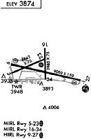
| A81-APT | WHEN ATCT CLSD ACTVT MALSR RWY 27; REIL RWY 09, 17 & 35; PAPI RWY 09 & 27; HIRL RWY 09/27; MIRL RWY 05/23 & 17/35; - CTAF. |
Runways
Runway Summary
| Runways: | 05/23 09/27 10/28 17/35 |
| Longest Runway: | 09/27 is 9000 ft (2743 m) long |
| Runways with an Instrument Approach: | 27 |
HLN Airport Runway Details
| Runway 05/23 | 4644 ft x 75 ft (1415 m x 23 m) | |
| Runway Length Source: | 3RD PARTY SURVEY as of 06/21/2015 | |
| Surface: | Asphalt - Fair condition - Porous friction course | |
| Runway Pavement Class: | 6 /F/C/X/U | |
| Runway Edge Lights: | Medium Intensity | |
Runway Weight Bearing Capacity (in thousands of pounds) |
||
| Single Wheel Landing Gear: | 21.0 | |
| Dual Wheel Landing Gear: | 30.0 | |
Runway 05 |
Runway 23 |
|
Elevation: |
3877.2 | 3819.6 |
Latitude: |
46-36-20.1485N | 46-36-38.6134N |
Longitude: |
111-59-50.7999W | 111-58-49.9340W |
|
Runway True Alignment: |
066 | 246 |
Glide Path Angle: |
3.0 degrees | 3.0 degrees |
Traffic Pattern: |
Left | Right |
Runway Markings Type: |
Basic | Basic |
Runway Markings Condition: |
Good | Good |
Object at End: |
ROAD | FENCE |
Object Height: |
22 | 8 |
Object Marked/Lighted?: |
Marked | |
Distance from End: |
425 | 550 |
Object Centerline Offset: |
136 ft. left of centerline | 165 ft. left of centerline |
Visual Glide Slope Indicators: |
2-Light PAPI On Left Side Of Runway | 2-Light PAPI On Left Side Of Runway |
Threshold Crossing Height: |
40 | 49 |
Declared Distances |
||
Take Off Run Avbl. (TORA): |
4644 | 4644 |
Take Off Distance Avbl. (TODA): |
4644 | 4644 |
Actual Stop Dist. Avbl. (ASDA): |
4644 | 4644 |
Landing Dist. Avbl. (LDA): |
4644 | 4644 |
| Runway 09/27 | 9000 ft x 150 ft (2743 m x 46 m) | |
| Runway Length Source: | 3RD PARTY SURVEY as of 06/21/2015 | |
| Surface: | Asphalt - Fair condition - Porous friction course | |
| Runway Pavement Class: | 50 /F/C/X/U | |
| Runway Edge Lights: | High Intensity | |
Runway Weight Bearing Capacity (in thousands of pounds) |
||
| Dual Wheel Landing Gear: | 160.0 | |
| Dual Tandem Wheel Landing Gear: | 250.0 | |
| Dual Dual Tandem Wheel Landing Gear: | 420.0 | |
Runway 09 |
Runway 27 |
|
Elevation: |
3863.7 | 3844.8 |
Latitude: |
46-36-30.2886N | 46-36-10.7600N |
Longitude: |
111-59-51.6769W | 111-57-45.9550W |
|
Runway True Alignment: |
102 | 282 |
ILS Type: |
ILS | |
Glide Path Angle: |
3.3 degrees | 3.0 degrees |
Traffic Pattern: |
Left | Right |
Runway Markings Type: |
Precision Instrument | Precision Instrument |
Runway Markings Condition: |
Good | Good |
Object at End: |
GND | |
Object Height: |
6 | |
Distance from End: |
200 | |
Object Centerline Offset: |
136 ft. left of centerline | 165 ft. left of centerline |
Visual Glide Slope Indicators: |
4-Light PAPI On Left Side Of Runway | 4-Light PAPI On Left Side Of Runway |
Approach Light System: |
1,400 Foot Medium Intensity Approach Lighting System With Runway Alignment Indicator Lights | |
REIL: |
Yes | |
Threshold Crossing Height: |
55 | 55 |
Declared Distances |
||
Take Off Run Avbl. (TORA): |
9000 | 9000 |
Take Off Distance Avbl. (TODA): |
9000 | 9000 |
Actual Stop Dist. Avbl. (ASDA): |
9000 | 9000 |
Landing Dist. Avbl. (LDA): |
9000 | 9000 |
| Runway 10/28 | 1584 ft x 75 ft (483 m x 23 m) | |
| Runway Length Source: | 3RD PARTY SURVEY as of 06/21/2015 | |
| Surface: | Asphalt - Fair condition - No special surface treatment | |
Runway 10 |
Runway 28 |
|
Elevation: |
3855.9 | 3850.7 |
Latitude: |
46-36-22.5128N | 46-36-19.0598N |
Longitude: |
111-59-30.8337W | 111-59-08.7082W |
|
Runway True Alignment: |
103 | 283 |
Glide Path Angle: |
0.0 degrees | 0.0 degrees |
Object Centerline Offset: |
136 ft. left of centerline | 165 ft. left of centerline |
| Runway 17/35 | 2989 ft x 75 ft (911 m x 23 m) | |
| Runway Length Source: | 3RD PARTY SURVEY as of 06/06/2015 | |
| Surface: | Asphalt - Fair condition - Porous friction course | |
| Runway Pavement Class: | 5 /F/C/X/U | |
| Runway Edge Lights: | Medium Intensity | |
Runway 17 |
Runway 35 |
|
Elevation: |
3811.9 | 3862.3 |
Latitude: |
46-36-43.8205N | 46-36-14.3266N |
Longitude: |
111-58-50.7804W | 111-58-50.2896W |
|
Runway True Alignment: |
179 | 359 |
Glide Path Angle: |
0.0 degrees | 0.0 degrees |
Traffic Pattern: |
Left | Right |
Runway Markings Type: |
Basic | Basic |
Runway Markings Condition: |
Good | Good |
Object at End: |
GND | |
Object Height: |
4 | |
Distance from End: |
200 | |
Object Centerline Offset: |
136 ft. left of centerline | 165 ft. left of centerline |
REIL: |
Yes | Yes |
Declared Distances |
||
Take Off Run Avbl. (TORA): |
2989 | 2989 |
Take Off Distance Avbl. (TODA): |
2989 | 2989 |
Actual Stop Dist. Avbl. (ASDA): |
2989 | 2989 |
Landing Dist. Avbl. (LDA): |
2989 | 2989 |
Services
Airframe Repair: |
Major |
Powerplant Repair: |
Major |
Bottled Oxygen: |
None |
Bulk Oxygen: |
None |
Fuel Available: |
100LL, Jet A |
Landing Fees: |
No |
Parking: |
Tiedowns available |
Maps & Diagrams
HLN Sectional
Flight Planning
at skyvector.com
at skyvector.com