Location
Latitude: |
45-41-57.9000N (45.699417) |
Longitude: |
110-26-52.9000W (-110.448028) |
Elevation: |
4659.4 feet MSL (1420 m MSL) |
Magnetic Variation: |
11.1 E (as of April 2024 from WMM2020 model) |
Time Zone: |
UTC -7.0 (Standard Time) UTC -6.0 (Daylight Savings Time) |
From City: |
05 N.M. E of Livingston, Montana |
Found On: |
Great Falls Chart |
FAA Region: |
ANM |
Contacts
Manager: |
Publicly owned: |
| PAUL LYMAN COUNTY BLDG, 414 E CALLENDER LIVINGSTON, MT 59047 406-451-1944 |
LIVINGSTON CITY PARK CO COUNTY BLDG, 414 E CALLENDER LIVINGSTON, MT 59047 406-222-4106 |
Operations
Airport Status: |
Operational |
Facility Use: |
Public |
Type: |
Airport |
Activation Date: |
03/1943 |
Control tower: |
No |
Attendance (Months/Days/Hours): |
Months/Days/Hours ALL/ALL/0800-1700 |
Boundary ARTCC: |
ZLC (Salt Lake City) |
Responsible ARTCC: |
ZLC (Salt Lake City) |
Lighting Schedule: |
SEE RMK |
Segmented Circle Indicator: |
No |
Traffic Pattern Altitude (MSL): |
5659 feet (1725 m) |
NOTAMs Facility: |
LVM |
NOTAM-D Service: |
Yes |
International Airport of Entry: |
No |
Customs Landing Rights: |
No |
Military Landing Rights: |
Yes |
Civil/Military Joint Use: |
No |
Based Aircraft
| Single Engine: | 22 |
| Multi Engine: | 1 |
Annual Operations (as of 10/27/2020)
| Total Operations: | 10000 | |
| Air Taxi: | 500 | 5.0% |
| GA Local: | 5000 | 50.0% |
| GA Itinerant: | 4000 | 40.0% |
| Military Aircraft: | 500 | 5.0% |
Communications
| CTAF: | 123.000 |
| Unicom: | 123.000 |
| Approach: | BIG SKY 119.55 119.55 SALT LAKE ARTCC |
| Departure: | BIG SKY 119.55 119.55 SALT LAKE ARTCC |
| ASOS: | 135.275 (406-222-2338) |
- COMMUNICATIONS PRVDD BY GREAT FALLS RADIO ON FREQ 122.2 (LIVINGSTON RCO).
- APCH/DEP CTL SVC PRVDD BY SALT LAKE ARTCC (ZLC) ON FREQS 119.550/235.775 (LIVINGSTON A RCAG) WHEN BIG SKY APCH CTL (BOI) IS UNAVAILABLE 0715-1300Z++.
Fixed Based Operators (FBOs) & Fuel
(Click on a business for detail)
Please help us keep this information up to date. This is a FREE SERVICE just like everything else on Airport Guide! If you see that a business needs to be added, modified, or deleted please fill out our Update Form.
To add, modify, or delete a business click here.
Please help us keep this information up to date. This is a FREE SERVICE just like everything else on Airport Guide! If you see that a business needs to be added, modified, or deleted please fill out our Update Form.
Area Code: 406 |
| Business Name | Frequency | Phone | Fuel Grade |
|---|---|---|---|
| Yellowstone Air Service
Update FBO info |
Unicom 123.0 | 222-6504 | 100, Jet A |
Flight Service Stations
| Primary | Alternate | |
| FSS on Field: | ||
| FSS Name (ID): | Great Falls(GTF) | |
| Frequency: | ||
| Toll Free Phone: | 1-800-WX-BRIEF |
Instrument Procedures / Charts
FAA Terminal Procedures valid from 0901Z 03/21/24 to 0901Z 04/18/24.
There are various types of charts available for an airport. They are listed in the Page Type column. Here is a legend for those types:
APD - Airport Diagram
DP - Departure Procedure Charts
HOT - Hot Spots
IAP - Instrument Approach Procedure Charts
MIN - Minimums
STAR - Standard Terminal Arrival Charts
| Page Type | Page Name | Volume | Action Since Last Cycle |
|---|---|---|---|
| IAP | RNAV (GPS) RWY 22 | NW-1 | |
| IAP | VOR/DME-B | NW-1 | |
| MIN | ALTERNATE MINIMUMS | NW-1 | |
| MIN | TAKEOFF MINIMUMS | NW-1 | |
| ODP | LIVINGSTON TWO (OBSTACLE) | NW-1 |
Terminal Procedures are only available for airports in several countries with more being added all the time. If you are looking for a specific country's charts, please send an email to support(at)airportguide.com stating the country name. This will be used to prioritize the implementation.
Navigation Aids (Navaids) near LVM
| Dist (NM) | ID | Morse Code | Name | Type | Freq | True Hdg | Mag Hdg |
|---|---|---|---|---|---|---|---|
| 0.3 | LVM | . _ . . . . . _ _ _ | Livingston | VOR-DME | 116.10 | 51 | 40 |
| 30.1 | BZN | _ . . . _ _ . . _ . | Bozeman | VOR-DME | 112.40 | 279 | 268 |
| 36.5 | BZ | _ . . . _ _ . . | Manni | NDB | 266 | 286 | 275 |
| 51.0 | HWQ | . . . . . _ _ _ _ . _ | Harlowton | NDB | 242 | 29 | 18 |
| 56.9 | EKS | . _ . _ . . . | Ennis | NDB | 286 | 243 | 232 |
| 66.9 | ESY | . . . . _ . _ _ | Yellowstone | NDB | 338 | 205 | 194 |
| 67.8 | WYS | . _ _ _ . _ _ . . . | West Yellowstone | DME | 114.85 | 205 | 194 |
| 72.7 | HIA | . . . . . . . _ | Whitehall | VOR-DME | 113.70 | 278 | 267 |
| 74.0 | BI | _ . . . . . | Saige | NDB | 251 | 82 | 71 |
| 74.5 | LO | . _ . . _ _ _ | Targy | NDB | 415 | 205 | 194 |
| 75.4 | HAU | . . . . . _ . . _ | Hauser | NDB | 386 | 314 | 303 |
| 76.6 | BIL | _ . . . . . . _ . . | Billings | VORTAC | 114.50 | 84 | 73 |
| 82.4 | CVP | _ . _ . . . . _ . _ _ . | Capitol | NDB | 335 | 311 | 300 |
| 82.9 | HLN | . . . . . _ . . _ . | Helena | VORTAC | 117.70 | 311 | 300 |
| 86.1 | POY | . _ _ . _ _ _ _ . _ _ | Powell | NDB | 344 | 124 | 113 |
| 88.4 | LWT | . _ . . . _ _ _ | Lewistown | VOR-DME | 115.45 | 22 | 11 |
| 90.2 | COD | _ . _ . _ _ _ _ . . | Cody | VOR-DME | 111.80 | 135 | 124 |
| 91.5 | RPX | . _ . . _ _ . _ . . _ | Roundup | NDB | 362 | 58 | 47 |
| 92.4 | DLN | _ . . . _ . . _ . | Dillon | VOR-DME | 113.00 | 253 | 242 |
| 96.8 | HCY | . . . . _ . _ . _ . _ _ | Cowley | NDB | 257 | 118 | 107 |
Nearby Airports with Fuel
Notices to Airmen (NOTAMS)
Remarks
| A110-1 | RWY 31 MTN 1 MILE AT 23:1 RATIO. |
| A110-3 | WILDLIFE ON & INVOF ARPT. |
| A110-4 | AG OPS APR THROUGH SEP. |
| A110-5 | FOR CD IF UNA TO CTC ON FSS FREQ, CTC SALT LAKE ARTCC AT 801-320-2568. |
| A110-6 | COLD TEMPERATURE AIRPORT. ALTITUDE CORRECTION REQUIRED AT OR BELOW -29C. |
| A110-7 | PAPI RWY 22 OPR CONSLY. |
| A24 | LDG FEE FOR ACFT OVR 12500 LBS. |
| A42-08 | RYS 08 & 26 THLDS & FIRST 200 FT MKD WITH WHITE CONES. |
| A42-13 | RYS 13 & 31 THLDS & FIRST 200 FT MKD WITH WHITE CONES. |
| A43-22 | PAPI UNUSBL BYD 5 DEGS RIGHT OF CNTRLN. |
| A70-FUEL-A | WKENDS AND AFT HRS CALL 406-222-6504. |
| A81-APT | ACTIVATE MIRL RY 04/22 - 123.0. |
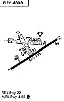
Runways
Runway Summary
| Runways: | 04/22 08/26 13/31 |
| Longest Runway: | 04/22 is 5701 ft (1738 m) long |
| Runways with an Instrument Approach: |
LVM Airport Runway Details
| Runway 04/22 | 5701 ft x 75 ft (1738 m x 23 m) | |
| Runway Length Source: | 3RD PARTY SURVEY as of 07/09/2009 | |
| Surface: | Asphalt - Excellent condition - No special surface treatment | |
| Runway Pavement Class: | 24 /F/A/Y/U | |
| Runway Edge Lights: | Medium Intensity | |
Runway Weight Bearing Capacity (in thousands of pounds) |
||
| Single Wheel Landing Gear: | 75.0 | |
| Dual Wheel Landing Gear: | 99.9 | |
Runway 04 |
Runway 22 |
|
Elevation: |
4649.6 | 4646.3 |
Latitude: |
45-41-35.9594N | 45-42-08.5238N |
Longitude: |
110-27-18.2728W | 110-26-12.7740W |
|
Runway True Alignment: |
054 | 234 |
Glide Path Angle: |
0.0 degrees | 3.0 degrees |
Traffic Pattern: |
Left | Left |
Runway Markings Type: |
Nonprecision Instrument | Nonprecision Instrument |
Runway Markings Condition: |
Good | Good |
Visual Glide Slope Indicators: |
4-Light PAPI On Left Side Of Runway | |
REIL: |
Yes | |
Threshold Crossing Height: |
44 |
| Runway 08/26 | 3762 ft x 125 ft (1147 m x 38 m) | |
| Runway Length Source: | 3RD PARTY SURVEY as of 07/09/2009 | |
| Surface: | Asphalt - Excellent condition - No special surface treatment | |
Runway 08 |
Runway 26 |
|
Elevation: |
4658.6 | 4650.2 |
Latitude: |
45-42-05.4904N | 45-42-03.6099N |
Longitude: |
110-27-22.8537W | 110-26-29.9283W |
|
Runway True Alignment: |
093 | 273 |
Glide Path Angle: |
0.0 degrees | 0.0 degrees |
Traffic Pattern: |
Left | Left |
Runway Markings Type: |
Nonstandard (other than numbers only) | Nonstandard (other than numbers only) |
Runway Markings Condition: |
Good | Good |
| Runway 13/31 | 2724 ft x 120 ft (830 m x 37 m) | |
| Runway Length Source: | 3RD PARTY SURVEY as of 07/09/2009 | |
| Surface: | Asphalt - Excellent condition - No special surface treatment | |
Runway 13 |
Runway 31 |
|
Elevation: |
4659.4 | 4651.5 |
Latitude: |
45-42-11.9346N | 45-41-49.4184N |
Longitude: |
110-27-14.0521W | 110-26-53.0830W |
|
Runway True Alignment: |
147 | 327 |
Glide Path Angle: |
0.0 degrees | 0.0 degrees |
Traffic Pattern: |
Left | Left |
Runway Markings Type: |
Nonstandard (other than numbers only) | Nonstandard (other than numbers only) |
Runway Markings Condition: |
Good | Good |
Services
Airframe Repair: |
None |
Powerplant Repair: |
None |
Bottled Oxygen: |
None |
Bulk Oxygen: |
None |
Fuel Available: |
100LL |
Landing Fees: |
No |
Parking: |
Tiedowns available |
Maps & Diagrams
LVM Sectional
Flight Planning
at skyvector.com
at skyvector.com