Location
Latitude: |
29-43-39.1780N (29.727549) |
Longitude: |
085-01-38.5590W (-85.027378) |
Elevation: |
19.6 feet MSL (6 m MSL) |
Magnetic Variation: |
4.7 W (as of April 2024 from WMM2020 model) |
Time Zone: |
UTC -5.0 (Standard Time) UTC -4.0 (Daylight Savings Time) |
From City: |
02 N.M. W of Apalachicola, Florida |
Found On: |
New Orleans Chart |
FAA Region: |
ASO |
Contacts
Manager: |
Publicly owned: |
| TED MOSTELLER 8 AIRPORT ROAD APALACHICOLA, FL 32320-2317 850-653-5115 |
FRANKLIN COUNTY 33 MARKET STREET, SUITE 203 APALACHICOLA, FL 32320-2317 850-653-9783 |
Operations
Airport Status: |
Operational |
Facility Use: |
Public |
Type: |
Airport |
Activation Date: |
02/1944 |
Control tower: |
No |
Attendance (Months/Days/Hours): |
Months/Days/Hours ALL/ALL/0800-1900 |
Boundary ARTCC: |
ZJX (Jacksonville) |
Responsible ARTCC: |
ZJX (Jacksonville) |
Lighting Schedule: |
SEE RMK |
Segmented Circle Indicator: |
No |
Traffic Pattern Altitude (MSL): |
1020 feet (311 m) |
NOTAMs Facility: |
AAF |
NOTAM-D Service: |
Yes |
International Airport of Entry: |
No |
Customs Landing Rights: |
No |
Military Landing Rights: |
Yes |
Civil/Military Joint Use: |
No |
Based Aircraft
| Single Engine: | 28 |
| Multi Engine: | 2 |
Annual Operations (as of 04/03/2018)
| Total Operations: | 24375 | |
| Air Taxi: | 1228 | 5.0% |
| GA Local: | 15000 | 61.5% |
| GA Itinerant: | 8000 | 32.8% |
| Military Aircraft: | 147 | 0.6% |
Communications
| CTAF: | 122.800 |
| Unicom: | 122.800 |
| Approach: | TYNDALL 124.15 ;ABV 5000 FT 124.15 ;ABV 5000 FT 124.15 ;ABV 5000 FT JAX ARTCC |
| Departure: | TYNDALL 124.15 ;ABV 5000 FT 124.15 ;ABV 5000 FT 124.15 ;ABV 5000 FT JAX ARTCC |
| ASOS: | 119.925 (850-653-1229) |
- APCH/DEP SVC PRVDD BY JAX ARTCC ON FREQS 120.825/379.3 (PANAMA CITY RCAG) WHEN TYNDALL APCH CTL IS CLSD.
Fixed Based Operators (FBOs) & Fuel
(Click on a business for detail)
Please help us keep this information up to date. This is a FREE SERVICE just like everything else on Airport Guide! If you see that a business needs to be added, modified, or deleted please fill out our Update Form.
To add, modify, or delete a business click here.
Please help us keep this information up to date. This is a FREE SERVICE just like everything else on Airport Guide! If you see that a business needs to be added, modified, or deleted please fill out our Update Form.
Area Code: 850 |
| Business Name | Frequency | Phone | Fuel Grade |
|---|---|---|---|
| Apalachicola International Aviation
Update FBO info |
653-2222, after hours call 800-653-2670 | 100LL, Jet A |
Flight Service Stations
| Primary | Alternate | |
| FSS on Field: | N | |
| FSS Name (ID): | Gainesville(GNV) | |
| Frequency: | ||
| Toll Free Phone: | 1-800-WX-BRIEF |
Instrument Procedures / Charts
FAA Terminal Procedures valid from 0901Z 03/21/24 to 0901Z 04/18/24.
There are various types of charts available for an airport. They are listed in the Page Type column. Here is a legend for those types:
APD - Airport Diagram
DP - Departure Procedure Charts
HOT - Hot Spots
IAP - Instrument Approach Procedure Charts
MIN - Minimums
STAR - Standard Terminal Arrival Charts
| Page Type | Page Name | Volume | Action Since Last Cycle |
|---|---|---|---|
| IAP | RNAV (GPS) RWY 06 | SE-3 | |
| IAP | RNAV (GPS) RWY 14 | SE-3 | |
| IAP | RNAV (GPS) RWY 24 | SE-3 | |
| IAP | RNAV (GPS) RWY 32 | SE-3 | |
| MIN | ALTERNATE MINIMUMS | SE-3 | |
| MIN | TAKEOFF MINIMUMS | SE-3 |
Terminal Procedures are only available for airports in several countries with more being added all the time. If you are looking for a specific country's charts, please send an email to support(at)airportguide.com stating the country name. This will be used to prioritize the implementation.
Navigation Aids (Navaids) near AAF
| Dist (NM) | ID | Morse Code | Name | Type | Freq | True Hdg | Mag Hdg |
|---|---|---|---|---|---|---|---|
| 0.3 | AAF | . _ . _ . . _ . | Apalachicola | NDB | 349 | 188 | 193 |
| 35.2 | PAM | . _ _ . . _ _ _ | Tyndall | TACAN | 133.70 | 306 | 311 |
| 50.0 | TL | _ . _ . . | Wakul | NDB | 379 | 43 | 48 |
| 52.7 | TLH | _ . _ . . . . . . | Tallahassee Muni | VOT | 111.00 | 41 | 46 |
| 53.2 | PFN | . _ _ . . . _ . _ . | Lynne | NDB | 278 | 312 | 316 |
| 60.2 | SZW | . . . _ _ . . . _ _ | Seminole | VORTAC | 117.50 | 34 | 39 |
| 63.7 | MAI | _ _ . _ . . | Marianna | VORTAC | 114.00 | 355 | 360 |
| 69.4 | SMY | . . . _ _ _ . _ _ | Soyya | NDB | 329 | 351 | 356 |
| 73.7 | BKK | _ . . . _ . _ _ . _ | Tri County | NDB | 275 | 336 | 341 |
| 79.1 | LYZ | . _ . . _ . _ _ _ _ . . | Willis | NDB | 359 | 19 | 24 |
| 81.3 | GEF | _ _ . . . . _ . | Greenville | VORTAC | 113.65 | 52 | 57 |
| 82.9 | CYR | _ . _ . _ . _ _ . _ . | Caidy | NDB | 338 | 32 | 37 |
| 89.7 | DWG | _ . . . _ _ _ _ . | Warrington | TACAN | 134.50 | 300 | 304 |
| 95.7 | RRS | . _ . . _ . . . . | Wiregrass | VORTAC | 111.60 | 347 | 352 |
| 96.0 | HRT | . . . . . _ . _ | Hurlburt | TACAN | 110.80 | 296 | 300 |
| 96.5 | GTP | _ _ . _ . _ _ . | Paton | NDB | 245 | 39 | 44 |
| 98.1 | CXU | _ . _ . _ . . _ . . _ | Camilla | NDB | 369 | 24 | 29 |
| 98.7 | OZ | _ _ _ _ _ . . | Brynt | NDB | 212 | 335 | 340 |
| 99.3 | OZR | _ _ _ _ _ . . . _ . | Cairns | VOR-DME | 111.20 | 338 | 343 |
Nearby Airports with Fuel
Notices to Airmen (NOTAMS)
Remarks
| A110-1 | FOR CD CTC TYNDALL APCH AT 850-283-2900 OR 850-283-3353, WHEN APCH CLSD CTC JACKSONVILLE ARTCC AT 904-845-1592. |
| A30A-06 | UNLGTD OBSTNS IN APCH; 60 FT TREES 1390 FT BFR AER. |
| A30A-18 | UNLGTD OBSTNS IN APCH; 71 FT TREES 1205 FT BFR AER. |
| A30A-24 | UNLGTD OBSTNS IN APCH; 47 FT TREES 985 FT BFR AER. |
| A57-14 | RWY 32 APCH RATIO 25:1 TO AER. |
| A57-18 | RWY 18 APCH RATIO 17:1 TO AER. |
| A57-36 | APCH RATIO 28:1 TO DTHR. |
| A81-APT | ACTVT PAPI RWY 6, 24, 14, & 32; MIRL RWY 06/24 & 14/32 - CTAF. |
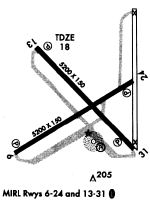
Runways
Runway Summary
| Runways: | 06/24 14/32 18/36 |
| Longest Runway: | 14/32 is 5425 ft (1654 m) long |
| Runways with an Instrument Approach: |
AAF Airport Runway Details
| Runway 06/24 | 5271 ft x 150 ft (1607 m x 46 m) | |
| Runway Length Source: | 3RD PARTY SURVEY as of 11/12/2019 | |
| Surface: | Concrete - Fair condition - No special surface treatment | |
| Runway Pavement Class: | 12 /R/B/X/T | |
| Runway Edge Lights: | Medium Intensity | |
Runway 06 |
Runway 24 |
|
Elevation: |
19.4 | 19.3 |
Latitude: |
29-43-20.4703N | 29-43-46.3349N |
Longitude: |
085-02-14.7297W | 085-01-22.8104W |
|
Runway True Alignment: |
060 | 240 |
Glide Path Angle: |
3.0 degrees | 3.0 degrees |
Runway Markings Type: |
Nonprecision Instrument | Nonprecision Instrument |
Runway Markings Condition: |
Good | Good |
Object at End: |
TREES | TREES |
Object Height: |
59 | 47 |
Distance from End: |
1390 | 985 |
Object Centerline Offset: |
175 ft. right of centerline | 130 ft. left of centerline |
Visual Glide Slope Indicators: |
2-Light PAPI On Left Side Of Runway | 2-Light PAPI On Left Side Of Runway |
Threshold Crossing Height: |
40 | 40 |
Threshold Elevation: |
19.5 | |
Displaced Threshold: |
217 | |
Threshold Latitude: |
29-43-45.2671N | |
Threshold Longitude: |
085-01-24.9524W |
| Runway 14/32 | 5425 ft x 150 ft (1654 m x 46 m) | |
| Runway Length Source: | 3RD PARTY SURVEY as of 11/12/2019 | |
| Surface: | Concrete - Fair condition - No special surface treatment | |
| Runway Pavement Class: | 12 /R/B/X/T | |
| Runway Edge Lights: | Medium Intensity | |
Runway 14 |
Runway 32 |
|
Elevation: |
15.1 | 18.2 |
Latitude: |
29-43-58.0406N | 29-43-19.8607N |
Longitude: |
085-02-05.0860W | 085-01-21.8192W |
|
Runway True Alignment: |
135 | 315 |
Glide Path Angle: |
3.0 degrees | 3.0 degrees |
Traffic Pattern: |
Left | Left |
Runway Markings Type: |
Nonprecision Instrument | Nonprecision Instrument |
Runway Markings Condition: |
Good | Good |
Object at End: |
TREES | BRUSH |
Object Height: |
23 | 6 |
Distance from End: |
975 | 240 |
Object Centerline Offset: |
175 ft. right of centerline | 130 ft. left of centerline |
Visual Glide Slope Indicators: |
2-Light PAPI On Left Side Of Runway | 2-Light PAPI On Left Side Of Runway |
Threshold Crossing Height: |
40 | 66 |
| Runway 18/36 | 5251 ft x 150 ft (1601 m x 46 m) | |
| Runway Length Source: | 3RD PARTY SURVEY as of 11/12/2019 | |
| Surface: | Concrete - Fair condition - No special surface treatment | |
| Runway Pavement Class: | 12 /R/B/X/T | |
Runway 18 |
Runway 36 |
|
Elevation: |
15.1 | 19.5 |
Latitude: |
29-44-11.1962N | 29-43-19.2191N |
Longitude: |
085-01-23.0882W | 085-01-23.4150W |
|
Runway True Alignment: |
180 | 000 |
Glide Path Angle: |
0.0 degrees | 0.0 degrees |
Runway Markings Type: |
Basic | Basic |
Runway Markings Condition: |
Good | Good |
Object at End: |
TREES | TREE |
Object Height: |
71 | 38 |
Distance from End: |
1205 | 540 |
Object Centerline Offset: |
175 ft. right of centerline | 130 ft. left of centerline |
Threshold Elevation: |
19.5 | |
Displaced Threshold: |
502 | |
Threshold Latitude: |
29-43-24.1860N | |
Threshold Longitude: |
085-01-23.3874W |
Services
Airframe Repair: |
Major |
Powerplant Repair: |
Major |
Bottled Oxygen: |
High Pressure |
Bulk Oxygen: |
High Pressure |
Fuel Available: |
100LL, Jet A, Jet A-1+ |
Landing Fees: |
No |
Parking: |
Tiedowns available |
Maps & Diagrams
AAF Sectional
Flight Planning
at skyvector.com
at skyvector.com