Location
Latitude: |
31-36-21.0000N (31.605833) |
Longitude: |
090-24-33.5000W (-90.409306) |
Elevation: |
492.3 feet MSL (150 m MSL) |
Magnetic Variation: |
1.3 W (as of April 2024 from WMM2020 model) |
Time Zone: |
UTC -6.0 (Standard Time) UTC -5.0 (Daylight Savings Time) |
From City: |
03 N.M. NE of Brookhaven, Mississippi |
Found On: |
New Orleans Chart |
FAA Region: |
ASO |
Contacts
Manager: |
Publicly owned: |
| JOHN COLEMAN 1216 HEUCKS RETREAT RD BROOKHAVEN, MS 39601 601-833-0999 |
CITY OF BROOKHAVEN 300 SOUTH 1ST ST BROOKHAVEN, MS 39601 601-833-2362 |
Operations
Airport Status: |
Operational |
Facility Use: |
Public |
Type: |
Airport |
Activation Date: |
06/1955 |
Control tower: |
No |
Attendance (Months/Days/Hours): |
Months/Days/Hours ALL/MON-FRI/0800-1700 |
Boundary ARTCC: |
ZHU (Houston) |
Responsible ARTCC: |
ZHU (Houston) |
Lighting Schedule: |
SEE RMK |
Segmented Circle Indicator: |
Yes |
Traffic Pattern Altitude (MSL): |
1492 feet (455 m) |
NOTAMs Facility: |
GWO |
NOTAM-D Service: |
Yes |
International Airport of Entry: |
No |
Customs Landing Rights: |
No |
Military Landing Rights: |
Yes |
Civil/Military Joint Use: |
No |
Based Aircraft
| Single Engine: | 16 |
| Multi Engine: | 7 |
| Jet Engine: | 1 |
| GA Helicopters: | 1 |
Annual Operations (as of 04/10/2023)
| Total Operations: | 9500 | |
| GA Local: | 3500 | 36.8% |
| GA Itinerant: | 6000 | 63.2% |
Communications
| CTAF: | 122.800 |
| Unicom: | 122.800 |
| AWOS-3P: | 118.125 (601-833-3209) |
- APCH/DEP SVC PRVDD BY HOUSTON ARTCC (ZHU) ON FREQS 126.8/327.8 (MC COMB RCAG).
Fixed Based Operators (FBOs) & Fuel
(Click on a business for detail)
Please help us keep this information up to date. This is a FREE SERVICE just like everything else on Airport Guide! If you see that a business needs to be added, modified, or deleted please fill out our Update Form.
To add, modify, or delete a business click here.
Please help us keep this information up to date. This is a FREE SERVICE just like everything else on Airport Guide! If you see that a business needs to be added, modified, or deleted please fill out our Update Form.
Area Code: 601 |
| Business Name | Frequency | Phone | Fuel Grade |
|---|---|---|---|
| Brookhaven Lincoln Co. Airport
Update FBO info |
Unicom 122.8 | 833-0999 | 100LL, Jet A |
Flight Service Stations
| Primary | Alternate | |
| FSS on Field: | N | |
| FSS Name (ID): | Greenwood(GWO) | |
| Frequency: | ||
| Toll Free Phone: | 1-800-WX-BRIEF |
Instrument Procedures / Charts
FAA Terminal Procedures valid from 0901Z 03/21/24 to 0901Z 04/18/24.
There are various types of charts available for an airport. They are listed in the Page Type column. Here is a legend for those types:
APD - Airport Diagram
DP - Departure Procedure Charts
HOT - Hot Spots
IAP - Instrument Approach Procedure Charts
MIN - Minimums
STAR - Standard Terminal Arrival Charts
| Page Type | Page Name | Volume | Action Since Last Cycle |
|---|---|---|---|
| IAP | RNAV (GPS) RWY 23 | SC-4 | |
| MIN | ALTERNATE MINIMUMS | SC-4 | |
| MIN | TAKEOFF MINIMUMS | SC-4 |
Terminal Procedures are only available for airports in several countries with more being added all the time. If you are looking for a specific country's charts, please send an email to support(at)airportguide.com stating the country name. This will be used to prioritize the implementation.
Navigation Aids (Navaids) near 1R7
| Dist (NM) | ID | Morse Code | Name | Type | Freq | True Hdg | Mag Hdg |
|---|---|---|---|---|---|---|---|
| 19.7 | MCB | _ _ _ . _ . _ . . . | Mc Comb | VORTAC | 116.70 | 156 | 157 |
| 21.7 | MC | _ _ _ . _ . | Ferni | NDB | 413 | 193 | 194 |
| 41.7 | RYB | . _ . _ . _ _ _ . . . | Raymond | NDB | 375 | 359 | 360 |
| 45.4 | HAH | . . . . . _ . . . . | Natchez-Adams County | NDB | 388 | 276 | 277 |
| 45.5 | HEZ | . . . . . _ _ . . | Natchez | VOR-DME | 110.00 | 271 | 272 |
| 45.8 | JAN | . _ _ _ . _ _ . | Jackson | VOT | 111.00 | 22 | 23 |
| 49.0 | JH | . _ _ _ . . . . | Brenz | NDB | 260 | 8 | 9 |
| 49.6 | TKH | _ _ . _ . . . . | Tallulah | NDB | 344 | 320 | 321 |
| 50.6 | JA | . _ _ _ . _ | Allen | NDB | 365 | 16 | 17 |
| 51.7 | GVB | _ _ . . . . _ _ . . . | Bogalusa | NDB | 353 | 146 | 147 |
| 52.1 | MHZ | _ _ . . . . _ _ . . | Magnolia | VORTAC | 113.20 | 17 | 18 |
| 55.5 | JAN | . _ _ _ . _ _ . | Jackson | VORTAC | 112.60 | 12 | 13 |
| 56.0 | LBY | . _ . . _ . . . _ . _ _ | Eaton | VORTAC | 110.60 | 101 | 103 |
| 60.0 | HP | . . . . . _ _ . | Anger | NDB | 212 | 180 | 181 |
| 62.5 | THJ | _ . . . . . _ _ _ | Tallahala | NDB | 346 | 85 | 87 |
| 65.2 | HMU | . . . . _ _ . . _ | Hammond | VOR | 109.60 | 180 | 181 |
| 71.7 | PCU | . _ _ . _ . _ . . . _ | Picayune | VOR-DME | 113.95 | 150 | 152 |
| 73.9 | BT | _ . . . _ | Rundi | NDB | 284 | 214 | 215 |
| 80.5 | FWX | . . _ . . _ _ _ . . _ | New Roads | NDB | 356 | 223 | 224 |
| 81.2 | LSU | . _ . . . . . . . _ | Fighting Tiger | VORTAC | 116.50 | 214 | 215 |
Nearby Airports with Fuel
Notices to Airmen (NOTAMS)
Remarks
| A110-6 | FOR CD CTC HOUSTON ARTCC AT 281-230-5622. |
| A110-7 | PAEW AT RANDOM TIMES. |
| A14 | JOE COX |
| A17 | AFT HRS - 601-754-6588. |
| A30A-23 | TALL TREES AER. |
| A57-05 | APCH RATIO 31:1 FM DTHR. |
| A57-23 | APCH RATIO 33:1 FM DTHR. |
| A70-FUEL-10 | 0LL FUEL SVC AVBL 24 HRS WITH CREDIT CARD. |
| A71 | AVBL - 601-695-9874. |
| A81-APT | ACTVT MIRL RWY 05/23 - CTAF. PAPI RWY 05 OPR DUSK-DAWN. PAPI RWY 23 OPR CONSLY. |
| A83 | WIND INDICATOR LGT OPR DUSK-DAWN. |
Runways
Runway Summary
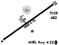
| Runways: | 05/23 |
| Longest Runway: | 05/23 is 5000 ft (1524 m) long |
| Runways with an Instrument Approach: |
1R7 Airport Runway Details
| Runway 05/23 | 5000 ft x 75 ft (1524 m x 23 m) | |
| Runway Length Source: | 3RD PARTY SURVEY as of 03/10/2010 | |
| Surface: | Asphalt - Fair condition - No special surface treatment | |
| Runway Edge Lights: | Medium Intensity | |
Runway Weight Bearing Capacity (in thousands of pounds) |
||
| Single Wheel Landing Gear: | 27.0 | |
Runway 05 |
Runway 23 |
|
Elevation: |
491.4 | 486.2 |
Latitude: |
31-36-04.3633N | 31-36-37.7047N |
Longitude: |
090-24-54.8854W | 090-24-12.1740W |
|
Runway True Alignment: |
048 | 228 |
Glide Path Angle: |
3.0 degrees | 3.0 degrees |
Traffic Pattern: |
Left | Left |
Runway Markings Type: |
Nonprecision Instrument | Nonprecision Instrument |
Runway Markings Condition: |
Fair | Fair |
Object at End: |
TREES | TREES |
Object Height: |
45 | 53 |
Distance from End: |
800 | 800 |
Object Centerline Offset: |
100 ft. left of centerline | 50 ft. left of centerline |
Visual Glide Slope Indicators: |
2-Light PAPI On Left Side Of Runway | 2-Light PAPI On Left Side Of Runway |
Threshold Crossing Height: |
40 | 40 |
Threshold Elevation: |
490.5 | 482.3 |
Displaced Threshold: |
635 | 994 |
Threshold Latitude: |
31-36-08.6017N | 31-36-31.0837N |
Threshold Longitude: |
090-24-49.4709W | 090-24-20.6670W |
Services
Airframe Repair: |
Minor |
Powerplant Repair: |
Minor |
Bottled Oxygen: |
None |
Bulk Oxygen: |
None |
Fuel Available: |
100LL |
Landing Fees: |
No |
Parking: |
Tiedowns available |
Maps & Diagrams
1R7 Sectional
Flight Planning
at skyvector.com
at skyvector.com