Location
Latitude: |
25-59-42.1000N (25.995028) |
Longitude: |
081-40-21.1000W (-81.672528) |
Elevation: |
5.2 feet MSL (2 m MSL) |
Magnetic Variation: |
6.3 W (as of May 2024 from WMM2020 model) |
Time Zone: |
UTC -5.0 (Standard Time) UTC -4.0 (Daylight Savings Time) |
From City: |
04 N.M. NE of Marco Island, Florida |
Found On: |
Miami Chart |
FAA Region: |
ASO |
Contacts
Manager: |
Publicly owned: |
| HEATHER MEYER 2005 MAINSAIL DRIVE, SUITE 1 NAPLES, FL 34114 239-252-1059 |
COLLIER COUNTY AIRPORT AUTHORITY 2005 MAINSAIL DRIVE NAPLES, FL 34114 239-252-8400 |
Operations
Airport Status: |
Operational |
Facility Use: |
Public |
Type: |
Airport |
Control tower: |
No |
Attendance (Months/Days/Hours): |
Months/Days/Hours ALL/ALL/0700-1900 |
Boundary ARTCC: |
ZMA (Miami) |
Responsible ARTCC: |
ZMA (Miami) |
Lighting Schedule: |
SEE RMK |
Segmented Circle Indicator: |
Yes |
Traffic Pattern Altitude (MSL): |
1005 feet (306 m) |
NOTAMs Facility: |
MIA |
NOTAM-D Service: |
Yes |
International Airport of Entry: |
No |
Customs Landing Rights: |
No |
Based Aircraft
| Single Engine: | 30 |
| Multi Engine: | 5 |
| Jet Engine: | 1 |
| GA Helicopters: | 1 |
Annual Operations (as of 12/31/2022)
| Total Operations: | 55374 | |
| GA Local: | 18254 | 33.0% |
| GA Itinerant: | 37062 | 66.9% |
| Military Aircraft: | 58 | 0.1% |
Communications
| CTAF: | 122.700 |
| Unicom: | 122.700 |
| Approach: | FORT MYERS MIAMI ARTCC |
| Departure: | FORT MYERS MIAMI ARTCC |
| AWOS-3PT: | 120.075 (239-394-8187) |
- APCH/DEP SVC PRVDD BY MIAMI ARTCC ON FREQS 134.75/322.5 (FORT MYERS RCAG) WHEN FORT MYERS APCH CTL CLSD.
Fixed Based Operators (FBOs) & Fuel
(Click on a business for detail)
Please help us keep this information up to date. This is a FREE SERVICE just like everything else on Airport Guide! If you see that a business needs to be added, modified, or deleted please fill out our Update Form.
To add, modify, or delete a business click here.
Please help us keep this information up to date. This is a FREE SERVICE just like everything else on Airport Guide! If you see that a business needs to be added, modified, or deleted please fill out our Update Form.
Area Code: 941 |
| Business Name | Frequency | Phone | Fuel Grade |
|---|---|---|---|
| Marco Aviation
Update FBO info |
Unicom 122.8 | 394-0010 | 100LL, Jet A |
| Marco Island Executive Airport
Update FBO info |
Unicom 122.8 | 394-3355 | 100LL, Jet A |
| Skyways
Update FBO info |
389-2750 |
Flight Service Stations
| Primary | Alternate | |
| FSS on Field: | N | |
| FSS Name (ID): | Miami(MIA) | |
| Frequency: | ||
| Toll Free Phone: | 1-800-WX-BRIEF |
Instrument Procedures / Charts
FAA Terminal Procedures valid from 0901Z 03/21/24 to 0901Z 04/18/24.
There are various types of charts available for an airport. They are listed in the Page Type column. Here is a legend for those types:
APD - Airport Diagram
DP - Departure Procedure Charts
HOT - Hot Spots
IAP - Instrument Approach Procedure Charts
MIN - Minimums
STAR - Standard Terminal Arrival Charts
| Page Type | Page Name | Volume | Action Since Last Cycle |
|---|---|---|---|
| DP | CSHEL SIX (RNAV) | SE-3 | |
| IAP | RNAV (GPS) RWY 17 | SE-3 | |
| IAP | RNAV (GPS) RWY 35 | SE-3 | |
| MIN | ALTERNATE MINIMUMS | SE-3 | |
| MIN | TAKEOFF MINIMUMS | SE-3 | |
| STAR | PIKKR SEVEN (RNAV) | SE-3 | |
| STAR | SHFTY FIVE (RNAV) | SE-3 | |
| STAR | ZEILR FIVE | SE-3 | Changed |
Terminal Procedures are only available for airports in several countries with more being added all the time. If you are looking for a specific country's charts, please send an email to support(at)airportguide.com stating the country name. This will be used to prioritize the implementation.
Navigation Aids (Navaids) near MRK
| Dist (NM) | ID | Morse Code | Name | Type | Freq | True Hdg | Mag Hdg |
|---|---|---|---|---|---|---|---|
| 11.1 | CYY | _ . _ . _ . _ _ _ . _ _ | Cypress | VOR-DME | 108.60 | 329 | 335 |
| 32.6 | RSW | . _ . . . . . _ _ | Lee County | VORTAC | 114.15 | 350 | 356 |
| 34.7 | FM | . . _ . _ _ | Caloo | NDB | 341 | 334 | 340 |
| 36.6 | TN | _ _ . | Monry | NDB | 227 | 102 | 109 |
| 52.2 | LBV | . _ . . _ . . . . . . _ | La Belle | VORTAC | 110.40 | 16 | 22 |
| 57.9 | PGD | . _ _ . _ _ . _ . . | Punta Gorda | VOR | 110.20 | 342 | 348 |
| 66.5 | TM | _ _ _ | Qeezy | NDB | 266 | 108 | 115 |
| 70.8 | PHK | . _ _ . . . . . _ . _ | Pahokee | VOR-DME | 115.40 | 47 | 54 |
| 72.4 | DHP | _ . . . . . . . _ _ . | Dolphin | VORTAC | 113.90 | 99 | 106 |
| 74.9 | FX | . . _ . _ . . _ | Praiz | NDB | 221 | 80 | 87 |
| 75.8 | VNC | . . . _ _ . _ . _ . | Venice | NDB | 206 | 327 | 333 |
| 76.2 | HST | . . . . . . . _ | Homestead | TACAN | 108.20 | 113 | 120 |
| 76.2 | MIA | _ _ . . . _ | Miami Intl | VOT | 112.00 | 98 | 105 |
| 81.3 | FLL | . . _ . . _ . . . _ . . | Fort Lauderdale | VOR-DME | 114.40 | 86 | 93 |
| 83.1 | MTH | _ _ _ . . . . | Marathon | NDB | 260 | 157 | 163 |
| 83.2 | VKZ | . . . _ _ . _ _ _ . . | Virginia Key | VOR-DME | 117.10 | 99 | 106 |
| 84.8 | EYW | . _ . _ _ . _ _ | Key West | VORTAC | 113.50 | 184 | 190 |
| 84.9 | NQX | _ . _ _ . _ _ . . _ | Key West | TACAN | 113.10 | 180 | 186 |
| 87.0 | FIS | . . _ . . . . . . | Fish Hook | NDB | 332 | 184 | 190 |
| 90.4 | UTX | . . _ _ _ . . _ | United | NDB | 405 | 52 | 59 |
Nearby Airports with Fuel
Notices to Airmen (NOTAMS)
Remarks
| A110-10 | FOR CD CTC FORT MYERS APCH AT239-416-1026, WHEN APCH CLSD CTC MIAMI ARTCC AT 305-716-1731. |
| A110-11 | RWY 35 DSGND CALM WIND RWY FOR ARRS 2200-0700. RWY 17 DSGND CALM WIND RWY FOR DEPS 2200-0700. |
| A110-4 | ARPT VSBY UNRELIABLE. |
| A110-5 | NOISE SENSITIVE AREA. USE NBAA CLOSE IN NOISE ABATEMMENT PROCEDURES. |
| A110-6 | BANNER TOWING ON AND INVOF ARPT. |
| A110-8 | FOR FUEL AND SVC AFTER HRS CALL 239-394-3355. |
| A110-9 | NUMEROUS BIRDS & WILDLIFE ON AND INVOF ARPT. |
| A24 | RAMP FEE |
| A57-17 | RWY 17 APCH RATIO 34:1 TO RWY END. |
| A57-35 | RY 35 APCH RATIO 34:1 TO RY END. |
| A70-FUEL-10 | 0LL SELF SVC AVGAS 100LL AVBL 24 HRS BY CREDIT CARD. |
| A81-APT | ACTVT REIL RWY 17 & 35; PAPI RWY 17 & 35; MIRL RWY 17/35 - CTAF. |
Runways
Runway Summary
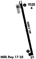
| Runways: | 17/35 |
| Longest Runway: | 17/35 is 5000 ft (1524 m) long |
| Runways with an Instrument Approach: | 17 |
MRK Airport Runway Details
| Runway 17/35 | 5000 ft x 100 ft (1524 m x 30 m) | |
| Runway Length Source: | STATE as of 06/15/2015 | |
| Surface: | Asphalt - Good condition - Saw-cut or plastic grooved | |
| Runway Pavement Class: | 26 /F/A/W/T | |
| Runway Edge Lights: | Medium Intensity | |
Runway Weight Bearing Capacity (in thousands of pounds) |
||
| Single Wheel Landing Gear: | 75.0 | |
| Dual Wheel Landing Gear: | 108.0 | |
Runway 17 |
Runway 35 |
|
Elevation: |
5.0 | 5.1 |
Latitude: |
26-00-06.3391N | 25-59-17.9521N |
Longitude: |
081-40-26.9390W | 081-40-15.2701W |
|
Runway True Alignment: |
168 | 348 |
ILS Type: |
LOCALIZER | |
Glide Path Angle: |
3.0 degrees | 3.0 degrees |
Traffic Pattern: |
Left | Right |
Runway Markings Type: |
Nonprecision Instrument | Nonprecision Instrument |
Runway Markings Condition: |
Fair | Fair |
Object at End: |
BRUSH | BRUSH |
Object Height: |
7 | 7 |
Distance from End: |
345 | 365 |
Object Centerline Offset: |
0 ft. left and right of centerline | 0 ft. left and right of centerline |
Visual Glide Slope Indicators: |
4-Light PAPI On Left Side Of Runway | 4-Light PAPI On Left Side Of Runway |
REIL: |
Yes | Yes |
Threshold Crossing Height: |
31 | 32 |
Services
Airframe Repair: |
Minor |
Powerplant Repair: |
Minor |
Bottled Oxygen: |
High Pressure / Low Pressure |
Bulk Oxygen: |
High Pressure / Low Pressure |
Fuel Available: |
100LL, Jet A-1+ |
Landing Fees: |
No |
Parking: |
Tiedowns available |
Maps & Diagrams
MRK Sectional
Flight Planning
at skyvector.com
at skyvector.com