Location
Latitude: |
39-54-04.2000N (39.901167) |
Longitude: |
083-08-12.9000W (-83.136917) |
Elevation: |
904.2 feet MSL (276 m MSL) |
Magnetic Variation: |
7.1 W (as of April 2024 from WMM2020 model) |
Time Zone: |
UTC -5.0 (Standard Time) UTC -4.0 (Daylight Savings Time) |
From City: |
08 N.M. SW of Columbus, Ohio |
Found On: |
Cincinnati Chart |
FAA Region: |
AGL |
Contacts
Manager: |
Publicly owned: |
| CHARLIE GOODWIN 2000 NORTON RD COLUMBUS, OH 43228-3667 614-851-9900 |
COLUMBUS REGIONAL ARPT AUTH 4600 INTERNATIONAL GTWY COLUMBUS, OH 43219-1779 614-239-4000 |
Operations
Airport Status: |
Operational |
Facility Use: |
Public |
Type: |
Airport |
Activation Date: |
09/1970 |
Control tower: |
Yes |
Attendance (Months/Days/Hours): |
Months/Days/Hours ALL/ALL/0730-1930 |
Boundary ARTCC: |
ZID (Indianapolis) |
Responsible ARTCC: |
ZID (Indianapolis) |
Lighting Schedule: |
SEE RMK |
Segmented Circle Indicator: |
No |
Traffic Pattern Altitude (MSL): |
1904 feet (580 m) |
NOTAMs Facility: |
TZR |
NOTAM-D Service: |
Yes |
International Airport of Entry: |
No |
Customs Landing Rights: |
No |
Military Landing Rights: |
Yes |
Civil/Military Joint Use: |
No |
Based Aircraft
| Single Engine: | 76 |
| Multi Engine: | 6 |
| GA Helicopters: | 3 |
Annual Operations (as of 06/07/2022)
| Total Operations: | 26932 | |
| Air Taxi: | 48 | 0.2% |
| GA Local: | 13998 | 52.0% |
| GA Itinerant: | 12834 | 47.7% |
| Military Aircraft: | 52 | 0.2% |
Communications
| CTAF: | 128.100 |
| Tower: | BOLTON 128.1 Hrs: 0730-1930 |
| Ground: | 121.8 |
| Approach: | COLUMBUS |
| Departure: | COLUMBUS |
| AWOS-3PT: | 135.925 (614-878-1722) |
- EMERG FREQ AVBL; NOT MONITORED ALL TIMES.
Fixed Based Operators (FBOs) & Fuel
(Click on a business for detail)
Please help us keep this information up to date. This is a FREE SERVICE just like everything else on Airport Guide! If you see that a business needs to be added, modified, or deleted please fill out our Update Form.
To add, modify, or delete a business click here.
Please help us keep this information up to date. This is a FREE SERVICE just like everything else on Airport Guide! If you see that a business needs to be added, modified, or deleted please fill out our Update Form.
Area Code: 614 |
| Business Name | Frequency | Phone | Fuel Grade |
|---|---|---|---|
| Business Aircraft Services
Update FBO info |
Arinc 131.6 | 878-1200 | 100LL, Jet A |
| CMH Aviation / Bolton Flying Service
Website Update FBO info |
123.3 | 878-2961, 800-787-3186 | 100LL |
Flight Service Stations
| Primary | Alternate | |
| FSS on Field: | N | |
| FSS Name (ID): | Dayton(DAY) | |
| Frequency: | ||
| Toll Free Phone: | 1-800-WX-BRIEF |
Instrument Procedures / Charts
FAA Terminal Procedures valid from 0901Z 03/21/24 to 0901Z 04/18/24.
There are various types of charts available for an airport. They are listed in the Page Type column. Here is a legend for those types:
APD - Airport Diagram
DP - Departure Procedure Charts
HOT - Hot Spots
IAP - Instrument Approach Procedure Charts
MIN - Minimums
STAR - Standard Terminal Arrival Charts
| Page Type | Page Name | Volume | Action Since Last Cycle |
|---|---|---|---|
| APD | AIRPORT DIAGRAM | EC-2 | |
| IAP | ILS OR LOC RWY 04 | EC-2 | |
| IAP | NDB RWY 04 | EC-2 | |
| IAP | RNAV (GPS) RWY 04 | EC-2 | |
| IAP | RNAV (GPS) RWY 22 | EC-2 | |
| MIN | ALTERNATE MINIMUMS | EC-2 | |
| MIN | TAKEOFF MINIMUMS | EC-2 | |
| STAR | CBUSS TWO (RNAV) | EC-2 | |
| STAR | CBUSS TWO (RNAV)[DELIMITER] CONT.1 | EC-2 | |
| STAR | CLPRR TWO (RNAV) | EC-2 | |
| STAR | CLPRR TWO (RNAV)[DELIMITER] CONT.1 | EC-2 | |
| STAR | DUBLN ONE (RNAV) | EC-2 | |
| STAR | DUBLN ONE (RNAV)[DELIMITER] CONT.1 | EC-2 | |
| STAR | SCRLT ONE (RNAV) | EC-2 | |
| STAR | SCRLT ONE (RNAV)[DELIMITER] CONT.1 | EC-2 |
Terminal Procedures are only available for airports in several countries with more being added all the time. If you are looking for a specific country's charts, please send an email to support(at)airportguide.com stating the country name. This will be used to prioritize the implementation.
Navigation Aids (Navaids) near KTZR
| Dist (NM) | ID | Morse Code | Name | Type | Freq | True Hdg | Mag Hdg |
|---|---|---|---|---|---|---|---|
| 5.8 | BU | _ . . . . . _ | Boutn | NDB | 230 | 212 | 219 |
| 8.2 | CHC | _ . _ . . . . . _ . _ . | Grens | NDB | 272 | 37 | 44 |
| 10.7 | OS | _ _ _ . . . | Fuler | NDB | 515 | 344 | 351 |
| 10.9 | DD | _ . . _ . . | Cobbs | NDB | 253 | 150 | 157 |
| 11.1 | LCK | . _ . . _ . _ . _ . _ | Rickenbacker | TACAN | 69X | 120 | 127 |
| 12.9 | CMH | _ . _ . _ _ . . . . | Port Columbus | VOT | 111.00 | 64 | 71 |
| 13.9 | LC | . _ . . _ . _ . | Pickl | NDB | 376 | 94 | 101 |
| 18.3 | CM | _ . _ . _ _ | Sumie | NDB | 391 | 73 | 80 |
| 21.5 | CSS | _ . _ . . . . . . . | Court House | NDB | 414 | 213 | 220 |
| 23.6 | XUB | _ . . _ . . _ _ . . . | Yellow Bud | VOR | 112.50 | 161 | 168 |
| 28.2 | RZT | . _ . _ _ . . _ | Ross County | NDB | 236 | 169 | 176 |
| 29.3 | APE | . _ . _ _ . . | Appleton | VORTAC | 116.70 | 59 | 66 |
| 29.6 | CCJ | _ . _ . _ . _ . . _ _ _ | Clark County | NDB | 341 | 267 | 274 |
| 31.9 | HEH | . . . . . . . . . | Newark | NDB | 524 | 76 | 83 |
| 32.6 | XSF | _ . . _ . . . . . _ . | Springfield | TACAN | 133.80 | 263 | 270 |
| 32.8 | SGH | . . . _ _ . . . . . | Springfield | DME | 113.2 | 263 | 270 |
| 37.0 | IL | . . . _ . . | Airbo | NDB | 407 | 228 | 235 |
| 41.4 | RUV | . _ . . . _ . . . _ | Rushsylvania | NDB | 326 | 324 | 331 |
| 41.7 | MXQ | _ _ _ . . _ _ _ . _ | Midwest | VOR-DME | 112.90 | 227 | 234 |
| 42.6 | FFO | . . _ . . . _ . _ _ _ | Patterson | TACAN | 109.20 | 263 | 270 |
Nearby Airports with Fuel
Notices to Airmen (NOTAMS)
Remarks
| A110-1 | HIGH TENSION PLINES/TOWERS NE-SE. |
| A110-2 | BLN & BANNER ACT ON & INVOF ARPT. |
| A110-3 | BIRDS & OTR WILDLIFE ON & INVOF ARPT. |
| A110-6 | FOR FUEL & ACFT SVCS CTC FBO ON 123.3. |
| A110-7 | FOR CD WHEN ATCT IS CLSD CTC COLUMBUS APCH AT 614-338-8537. |
| A16 | H24 EMERG OPS 614-239-4029. |
| A30A-04 | CALM WIND RWY. |
| A70-FUEL-10 | 0LL 100LL AVBL H24 SELF SVC VIA CREDIT CARD. |
| A75 | PPR CTC AMGR FOR INFO. |
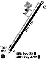
| A81-APT | WHEN ATCT CLSD ACTVT MALSR RWY 04; REIL RWY 22; MIRL RWY 04/22 - CTAF. |
Runways
Runway Summary
| Runways: | 04/22 |
| Longest Runway: | 04/22 is 5500 ft (1676 m) long |
| Runways with an Instrument Approach: | 04 |
KTZR Airport Runway Details
| Runway 04/22 | 5500 ft x 100 ft (1676 m x 30 m) | |
| Runway Length Source: | 3RD PARTY SURVEY as of 07/15/2008 | |
| Surface: | Asphalt - Fair condition - No special surface treatment | |
| Runway Edge Lights: | Medium Intensity | |
Runway Weight Bearing Capacity (in thousands of pounds) |
||
| Single Wheel Landing Gear: | 48.0 | |
| Dual Wheel Landing Gear: | 75.0 | |
| Dual Tandem Wheel Landing Gear: | 150.0 | |
Runway 04 |
Runway 22 |
|
Elevation: |
901.6 | 903.6 |
Latitude: |
39-53-41.1944N | 39-54-27.2022N |
Longitude: |
083-08-31.6443W | 083-07-54.0728W |
|
Runway True Alignment: |
032 | 212 |
ILS Type: |
ILS | |
Glide Path Angle: |
3.0 degrees | 3.0 degrees |
Traffic Pattern: |
Left | |
Runway Markings Type: |
Precision Instrument | Precision Instrument |
Runway Markings Condition: |
Good | Good |
Visual Glide Slope Indicators: |
4-Light PAPI On Left Side Of Runway | 4-Light PAPI On Left Side Of Runway |
Approach Light System: |
1,400 Foot Medium Intensity Approach Lighting System With Runway Alignment Indicator Lights | |
REIL: |
Yes | |
Threshold Crossing Height: |
25 | 25 |
Services
Airframe Repair: |
Major |
Powerplant Repair: |
Major |
Bottled Oxygen: |
None |
Bulk Oxygen: |
None |
Fuel Available: |
100LL, Jet A-1, Jet A-1+ |
Landing Fees: |
No |
Parking: |
Hangars and tiedowns available |
Maps & Diagrams
KTZR Sectional
Flight Planning
at skyvector.com
at skyvector.com