Location
Latitude: |
32-34-54.6000N (32.581833) |
Longitude: |
097-35-26.8000W (-97.590778) |
Elevation: |
873.2 feet MSL (266 m MSL) |
Magnetic Variation: |
3.2 E (as of May 2024 from WMM2020 model) |
Time Zone: |
UTC -6.0 (Standard Time) UTC -5.0 (Daylight Savings Time) |
From City: |
17 N.M. SW of Fort Worth, Texas |
Found On: |
Dallas-Ft Worth Chart |
FAA Region: |
ASW |
Contacts
Manager: |
Privately owned: |
| MARY JANE BUTT 101 CONSTELLATION DR CRESSON, TX 76035 817-752-4701 |
BOURLAND FIELD ESTATES HOA INC 101 CONSETELLATION DR CRESSON, TX 76035 817-396-4554 |
Operations
Airport Status: |
Operational |
Facility Use: |
Public |
Type: |
Airport |
Activation Date: |
09/1981 |
Control tower: |
No |
Attendance (Months/Days/Hours): |
Months/Days/Hours ALL/MON-SAT/DALGT |
Boundary ARTCC: |
ZFW (Fort Worth) |
Responsible ARTCC: |
ZFW (Fort Worth) |
Lighting Schedule: |
SEE RMK |
Segmented Circle Indicator: |
Yes |
Traffic Pattern Altitude (MSL): |
1873 feet (571 m) |
NOTAMs Facility: |
FTW |
NOTAM-D Service: |
Yes |
Based Aircraft
| Single Engine: | 100 |
| Multi Engine: | 20 |
| GA Helicopters: | 1 |
| Gliders: | 2 |
| Ultralights: | 2 |
Annual Operations (as of 10/31/2023)
| Total Operations: | 21900 | |
| GA Local: | 19710 | 90.0% |
| GA Itinerant: | 2190 | 10.0% |
Communications
| CTAF: | 123.000 |
| Unicom: | 123.000 |
| Approach: | REGIONAL |
| Departure: | REGIONAL |
Fixed Based Operators (FBOs) & Fuel
(Click on a business for detail)
Please help us keep this information up to date. This is a FREE SERVICE just like everything else on Airport Guide! If you see that a business needs to be added, modified, or deleted please fill out our Update Form.
To add, modify, or delete a business click here.
Please help us keep this information up to date. This is a FREE SERVICE just like everything else on Airport Guide! If you see that a business needs to be added, modified, or deleted please fill out our Update Form.
Area Code: 817 |
| Business Name | Frequency | Phone | Fuel Grade |
|---|---|---|---|
| Bourland Field
Update FBO info |
Unicom 123.0 | 817 512-3121 | 100LL, Jet A |
Flight Service Stations
| Primary | Alternate | |
| FSS on Field: | N | |
| FSS Name (ID): | Fort Worth(FTW) | |
| Frequency: | ||
| Toll Free Phone: | 1-800-WX-BRIEF |
Instrument Procedures / Charts
FAA Terminal Procedures valid from 0901Z 05/16/24 to 0901Z 06/13/24.
There are various types of charts available for an airport. They are listed in the Page Type column. Here is a legend for those types:
APD - Airport Diagram
DP - Departure Procedure Charts
HOT - Hot Spots
IAP - Instrument Approach Procedure Charts
MIN - Minimums
STAR - Standard Terminal Arrival Charts
| Page Type | Page Name | Volume | Action Since Last Cycle |
|---|---|---|---|
| DP | GARLAND FIVE | SC-2 | |
| DP | GARLAND FIVE[DELIMITER] CONT.1 | SC-2 | |
| DP | KINGDOM FOUR | SC-2 | |
| DP | KINGDOM FOUR[DELIMITER] CONT.1 | SC-2 | |
| DP | KUSSO ONE (RNAV) | SC-2 | |
| DP | KUSSO ONE (RNAV)[DELIMITER] CONT.1 | SC-2 | |
| DP | NANDR TWO (RNAV) | SC-2 | |
| DP | NANDR TWO (RNAV)[DELIMITER] CONT.1 | SC-2 | |
| DP | SWABR ONE (RNAV) | SC-2 | |
| DP | SWABR ONE (RNAV)[DELIMITER] CONT.1 | SC-2 | |
| IAP | RNAV (GPS) RWY 17 | SC-2 | |
| IAP | RNAV (GPS) RWY 35 | SC-2 | |
| MIN | TAKEOFF MINIMUMS | SC-2 | |
| STAR | LIKES THREE (RNAV) | SC-2 | |
| STAR | MOTZA ONE | SC-2 | Changed |
| STAR | MOTZA ONE[DELIMITER] CONT.1 | SC-2 | |
| STAR | REEKO THREE (RNAV) | SC-2 | |
| STAR | SASIE SEVEN | SC-2 | Changed |
| STAR | SASIE SEVEN[DELIMITER] CONT.1 | SC-2 | |
| STAR | TRUUK TWO (RNAV) | SC-2 | |
| STAR | WESAT TWO (RNAV) | SC-2 |
Terminal Procedures are only available for airports in several countries with more being added all the time. If you are looking for a specific country's charts, please send an email to support(at)airportguide.com stating the country name. This will be used to prioritize the implementation.
Navigation Aids (Navaids) near 50F
| Dist (NM) | ID | Morse Code | Name | Type | Freq | True Hdg | Mag Hdg |
|---|---|---|---|---|---|---|---|
| 13.7 | NFW | _ . . . _ . . _ _ | Nas Jrb Fort Worth | TACAN | 108.70 | 33 | 30 |
| 18.3 | FTW | . . _ . _ . _ _ | Fort Worth | VOT | 108.20 | 38 | 35 |
| 21.7 | FT | . . _ . _ | Mufin | NDB | 365 | 30 | 27 |
| 22.3 | MQP | _ _ _ _ . _ . _ _ . | Millsap | VORTAC | 117.70 | 292 | 289 |
| 27.8 | FUZ | . . _ . . . _ _ _ . . | Ranger | VORTAC | 115.70 | 48 | 45 |
| 29.2 | JEN | . _ _ _ . _ . | Glen Rose | TACAN | 115.00 | 209 | 206 |
| 32.7 | TTT | _ _ _ | Maverick | VOR-DME | 113.10 | 58 | 55 |
| 39.3 | CVE | _ . _ . . . . _ . | Cowboy | VOR-DME | 116.20 | 61 | 58 |
| 41.0 | DAL | _ . . . _ . _ . . | Dallas | VOT | 113.30 | 66 | 63 |
| 46.5 | DT | _ . . _ | Pinck | NDB | 257 | 25 | 22 |
| 53.7 | JUG | . _ _ _ . . _ _ _ . | Jecca | NDB | 388 | 84 | 81 |
| 55.3 | PQF | . _ _ . _ _ . _ . . _ . | Mesquite | NDB | 248 | 75 | 72 |
| 57.5 | GHX | _ _ . . . . . _ . . _ | Graham | NDB | 371 | 307 | 304 |
| 57.5 | ACT | . _ _ . _ . _ | Waco | VORTAC | 115.30 | 163 | 160 |
| 58.4 | UKW | . . _ _ . _ . _ _ | Bowie | VORTAC | 117.15 | 348 | 345 |
| 62.1 | GMZ | _ _ . _ _ _ _ . . | Grindstone Mountain | NDB | 356 | 351 | 348 |
| 62.7 | OIP | _ _ _ . . . _ _ . | Old Rip | NDB | 410 | 260 | 257 |
| 64.2 | MNZ | _ _ _ . _ _ . . | Hamilton | NDB | 251 | 206 | 203 |
| 64.9 | VLY | . . . _ . _ . . _ . _ _ | Melisa | NDB | 421 | 50 | 47 |
| 66.7 | CGQ | _ . _ . _ _ . _ _ . _ | Powell | NDB | 344 | 117 | 114 |
Nearby Airports with Fuel
Notices to Airmen (NOTAMS)
Remarks
| A110-1 | FOR CD CTC REGIONAL APCH AT 972-615-2799. |
| A110-2 | DEER ON & INVOF RWY. |
| A110-3 | RWY HOLD SHORT LINES NSTD 25 FT FM RWY EDGE. |
| A110-4 | ARPT CLSD TO TSNT STUDENT TFC. |
| A110-5 | ARPT CLSD TO ACFT OVR 12500 LB MAX GWT. |
| A13 | FBO PHONE. |
| A16 | BOURLANDAIRPORT50F@GMAIL.COM ALT PHONE 951-283-4076 |
| A17 | FOR SVCS AFT HRS CALL 817-752-4701. |
| A57-17 | APCH RATIO 0:1 AT DTHR OVR 20 FT BLDG, 0 FT DSTC. |
| A57-35 | APCH RATIO 0:1 AT DTHR OVR 40 FT TREE, O FT DSTC, 60 FT R. |
| A58-17 | 15 FT RD 0 FT DSTC 126 FT R. |
| A58-35 | 40 FT TREES 0-199 FT DSTC 60 FT R & 250 L/R. |
| A70-FUEL-10 | 0LL FUEL SELF SERVE. |
| A81-APT | ACTVT MIRL RWY 17/35 - CTAF. VASI RWYS 17 & 35 OPR CONSLY. |
| E111 | VFR ONLY. |
Runways
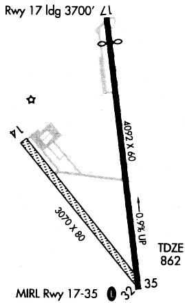
Runway Summary
| Runways: | 17/35 |
| Longest Runway: | 17/35 is 4049 ft (1234 m) long |
| Runways with an Instrument Approach: |
50F Airport Runway Details
| Runway 17/35 | 4049 ft x 60 ft (1234 m x 18 m) | |
| Runway Length Source: | 3RD PARTY SURVEY as of 09/01/2011 | |
| Surface: | Asphalt - Good condition - No special surface treatment | |
| Runway Edge Lights: | Medium Intensity | |
Runway 17 |
Runway 35 |
|
Elevation: |
873.1 | 836.7 |
Latitude: |
32-35-14.4314N | 32-34-34.8228N |
Longitude: |
097-35-30.3310W | 097-35-23.2854W |
|
Runway True Alignment: |
171 | 351 |
Glide Path Angle: |
3.0 degrees | 3.5 degrees |
Runway Markings Type: |
Nonprecision Instrument | Nonprecision Instrument |
Runway Markings Condition: |
Good | Good |
Object at End: |
ROAD | TREES |
Object Height: |
19 | 40 |
Distance from End: |
201 | 201 |
Object Centerline Offset: |
250 ft. left and right of centerline | 250 ft. left and right of centerline |
Visual Glide Slope Indicators: |
2-Box VASI On Left Side Of Runway | 2-Box VASI On Left Side Of Runway |
Threshold Crossing Height: |
23 | 28 |
Threshold Elevation: |
869.6 | 837.7 |
Displaced Threshold: |
392 | 215 |
Threshold Latitude: |
32-35-10.5933N | 32-34-36.9312N |
Threshold Longitude: |
097-35-29.6481W | 097-35-23.6602W |
Services
Airframe Repair: |
Major |
Powerplant Repair: |
Major |
Bottled Oxygen: |
None |
Bulk Oxygen: |
None |
Fuel Available: |
100LL, Jet A+ |
Landing Fees: |
No |
Parking: |
Tiedowns available |
Maps & Diagrams
50F Sectional
Flight Planning
at skyvector.com
at skyvector.com