Location
Latitude: |
28-49-20.1000N (28.82225) |
Longitude: |
099-06-32.5000W (-99.109028) |
Elevation: |
586.4 feet MSL (179 m MSL) |
Magnetic Variation: |
3.9 E (as of May 2024 from WMM2020 model) |
Time Zone: |
UTC -6.0 (Standard Time) UTC -5.0 (Daylight Savings Time) |
From City: |
04 N.M. S of Pearsall, Texas |
Found On: |
San Antonio Chart |
FAA Region: |
ASW |
Contacts
Manager: |
Privately owned: |
| IKE & NATHAN MC KINLEY 170 ENCINO PEARSALL, TX 78061 830-334-7306 |
AERIAL LLC BOX 764 PEARSALL, TX 78061 830-334-7306 |
Operations
Airport Status: |
Operational |
Facility Use: |
Public |
Type: |
Airport |
Activation Date: |
09/1955 |
Control tower: |
No |
Attendance (Months/Days/Hours): |
Months/Days/Hours ALL/ALL/ALL |
Boundary ARTCC: |
ZHU (Houston) |
Responsible ARTCC: |
ZHU (Houston) |
Lighting Schedule: |
SS-SR |
Segmented Circle Indicator: |
Yes |
Traffic Pattern Altitude (MSL): |
1586 feet (483 m) |
NOTAMs Facility: |
SJT |
NOTAM-D Service: |
Yes |
International Airport of Entry: |
No |
Customs Landing Rights: |
No |
Military Landing Rights: |
No |
Civil/Military Joint Use: |
No |
Based Aircraft
| Single Engine: | 3 |
Annual Operations (as of 05/26/2023)
| Total Operations: | 3870 | |
| GA Local: | 3270 | 84.5% |
| GA Itinerant: | 600 | 15.5% |
Communications
| CTAF: | 122.800 |
| Unicom: | 122.800 |
- APCH/DEP CTL SVC PRVDD BY HOUSTON ARTCC (ZHU) ON FREQS 134.6/322.5 (THREE RIVERS RCAG).
Fixed Based Operators (FBOs) & Fuel
(Click on a business for detail)
Please help us keep this information up to date. This is a FREE SERVICE just like everything else on Airport Guide! If you see that a business needs to be added, modified, or deleted please fill out our Update Form.
To add, modify, or delete a business click here.
Please help us keep this information up to date. This is a FREE SERVICE just like everything else on Airport Guide! If you see that a business needs to be added, modified, or deleted please fill out our Update Form.
Area Code: 830 |
| Business Name | Frequency | Phone | Fuel Grade |
|---|---|---|---|
| McKinlely Aerial Service
Update FBO info |
Unicom 122.8 | 830-334-7306 | 100LL, Jet A |

|
AvFuel | 100LL - 4.95 USD per gallon on 10/25/2020 |
|
|
|
AvFuel | Jet A-1 - 3.95 USD per gallon on 10/25/2020 |
|
Flight Service Stations
| Primary | Alternate | |
| FSS on Field: | N | |
| FSS Name (ID): | San Angelo(SJT) | |
| Frequency: | ||
| Toll Free Phone: | 1-800-WX-BRIEF |
Instrument Procedures / Charts
FAA Terminal Procedures valid from 0901Z 03/21/24 to 0901Z 04/18/24.
There are various types of charts available for an airport. They are listed in the Page Type column. Here is a legend for those types:
APD - Airport Diagram
DP - Departure Procedure Charts
HOT - Hot Spots
IAP - Instrument Approach Procedure Charts
MIN - Minimums
STAR - Standard Terminal Arrival Charts
| Page Type | Page Name | Volume | Action Since Last Cycle |
|---|---|---|---|
| IAP | VOR/DME OR GPS-A | SC-3 | |
| MIN | TAKEOFF MINIMUMS | SC-3 |
Terminal Procedures are only available for airports in several countries with more being added all the time. If you are looking for a specific country's charts, please send an email to support(at)airportguide.com stating the country name. This will be used to prioritize the implementation.
Navigation Aids (Navaids) near T30
| Dist (NM) | ID | Morse Code | Name | Type | Freq | True Hdg | Mag Hdg |
|---|---|---|---|---|---|---|---|
| 21.0 | HHH | . . . . . . . . . . . . | Devine | NDB | 359 | 25 | 21 |
| 21.6 | COT | _ . _ . _ _ _ _ | Cotulla | VORTAC | 115.80 | 181 | 177 |
| 31.8 | HDO | . . . . _ . . _ _ _ | Hondo | VOR-DME | 109.40 | 353 | 349 |
| 33.2 | HMA | . . . . _ _ . _ | Hondo | NDB | 329 | 354 | 350 |
| 38.8 | UVA | . . _ . . . _ . _ | Uvalde | NDB | 281 | 303 | 299 |
| 39.7 | LKX | . _ . . _ . _ _ . . _ | La Pryor | NDB | 223 | 279 | 275 |
| 41.9 | DMD | _ . . _ _ _ . . | Dimmit County | NDB | 343 | 244 | 240 |
| 43.6 | SSF | . . . . . . . . _ . | Stinson | VOR | 108.40 | 52 | 48 |
| 44.0 | KSY | _ . _ . . . _ . _ _ | Kelly | TACAN | 112.00 | 38 | 34 |
| 46.7 | CPZ | _ . _ . . _ _ . _ _ . . | Chaparrosa Ranch | NDB | 385 | 274 | 270 |
| 53.9 | THX | _ . . . . _ . . _ | Three Rivers | VORTAC | 111.40 | 110 | 106 |
| 54.2 | SAT | . . . . _ _ | San Antonio | VOT | 110.40 | 37 | 33 |
| 54.9 | AN | . _ _ . | Alamo | NDB | 368 | 30 | 26 |
| 59.8 | SAT | . . . . _ _ | San Antonio | VORTAC | 116.80 | 34 | 30 |
| 60.1 | RND | . _ . _ . _ . . | Randolph | VORTAC | 112.30 | 45 | 41 |
| 61.5 | DHK | _ . . . . . . _ . _ | Randolph | TACAN | 109.90 | 45 | 41 |
| 66.2 | CSI | _ . _ . . . . . . | Center Point | VORTAC | 117.50 | 355 | 351 |
| 71.9 | PFO | . _ _ . . . _ . _ _ _ | Spofford | NDB | 356 | 285 | 281 |
| 73.2 | AGH | . _ _ _ . . . . . | Ardyth | NDB | 405 | 194 | 190 |
| 76.0 | PNG | Piedras | VOR-DME | 113.60 | 261 | 257 |
Nearby Airports with Fuel
Notices to Airmen (NOTAMS)
Remarks
| A110*G | THIS AIRPORT HAS BEEN SURVEYED BY THE NATIONAL GEODETIC SURVEY. |
| A110-1 | FOR CD CTC HOUSTON ARTCC AT 281-230-5622. |
| A110-2 | DSPLCD THRS NOT LGTD, 4705 FT AVBL NGT. |
| A16 | ALT MGR NUMBER NATHAN MC KINLEY 210-542-0093 |
| A35-13/31 | ESTD. |
| A40-13/31 | NSTD LIRL; SPACING 20 FT FM EDGE & 300 FT BTN LGTS. |
| A42-13 | MKGS FADED. |
| A42-31 | MKGS FADED. |
| A57-13 | APCH RATIO 22:1 TO DSPLCD THR; 15 FT ROAD 330 FT FM DSPLCD THR 130 FT RIGHT. |
| A57-31 | RWY 31 APCH RATIO 37:1 TO DSPLCD THR. |
Runways
Runway Summary
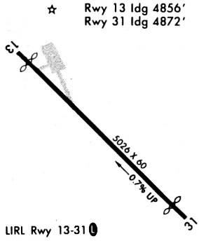
| Runways: | 13/31 |
| Longest Runway: | 13/31 is 5027 ft (1532 m) long |
| Runways with an Instrument Approach: |
T30 Airport Runway Details
| Runway 13/31 | 5027 ft x 60 ft (1532 m x 18 m) | |
| Surface: | Asphalt - Good condition - No special surface treatment | |
| Runway Edge Lights: | Low Intensity | |
Runway Weight Bearing Capacity (in thousands of pounds) |
||
| Single Wheel Landing Gear: | 15.0 | |
Runway 13 |
Runway 31 |
|
Elevation: |
586.4 | 553.8 |
Latitude: |
28-49-38.3550N | 28-49-01.8500N |
Longitude: |
099-06-51.7120W | 099-06-13.3060W |
|
Runway True Alignment: |
137 | 317 |
Glide Path Angle: |
0.0 degrees | 0.0 degrees |
Traffic Pattern: |
Left | Left |
Runway Markings Type: |
Basic | Basic |
Runway Markings Condition: |
Poor | Poor |
Object at End: |
ROAD | PLINE |
Object Height: |
15 | 60 |
Distance from End: |
201 | 2120 |
Object Centerline Offset: |
76 ft. right of centerline | 0 ft. left and right of centerline |
Threshold Elevation: |
585.7 | 554.1 |
Displaced Threshold: |
168 | 154 |
Threshold Latitude: |
28-49-37.1340N | 28-49-02.9670N |
Threshold Longitude: |
099-06-50.4270W | 099-06-14.4810W |
Services
Airframe Repair: |
Major |
Powerplant Repair: |
Major |
Bottled Oxygen: |
High Pressure |
Bulk Oxygen: |
None |
Fuel Available: |
100LL, Jet A |
Landing Fees: |
Yes |
Parking: |
Hangars and tiedowns available |
Maps & Diagrams
T30 Sectional
Flight Planning
at skyvector.com
at skyvector.com