Location
Latitude: |
41-59-07.6570N (41.98546) |
Longitude: |
097-26-06.4100W (-97.435114) |
Elevation: |
1572.6 feet MSL (479 m MSL) |
Magnetic Variation: |
3.2 E (as of April 2024 from WMM2020 model) |
Time Zone: |
UTC -6.0 (Standard Time) UTC -5.0 (Daylight Savings Time) |
From City: |
03 N.M. SW of Norfolk, Nebraska |
Found On: |
Omaha Chart |
FAA Region: |
ACE |
Contacts
Manager: |
Publicly owned: |
| MR ELIJAH MACKIE P.O. BOX 1343 NORFOLK, NE 68702-1343 402-841-5130 |
NORFOLK AIRPORT AUTHORITY P.O. BOX 1343 NORFOLK, NE 68702-1343 402-841-5130 |
Operations
Airport Status: |
Operational |
Facility Use: |
Public |
Type: |
Airport |
Activation Date: |
04/1940 |
Control tower: |
No |
Attendance (Months/Days/Hours): |
Months/Days/Hours ALL/SAT/0700-1700 |
Boundary ARTCC: |
ZMP (Minneapolis) |
Responsible ARTCC: |
ZMP (Minneapolis) |
Lighting Schedule: |
SEE RMK |
Segmented Circle Indicator: |
Yes |
Traffic Pattern Altitude (MSL): |
2573 feet (784 m) |
NOTAMs Facility: |
OFK |
NOTAM-D Service: |
Yes |
International Airport of Entry: |
No |
Customs Landing Rights: |
No |
Military Landing Rights: |
Yes |
Civil/Military Joint Use: |
No |
Based Aircraft
| Single Engine: | 38 |
| Multi Engine: | 6 |
| Jet Engine: | 1 |
Annual Operations (as of 07/12/2022)
| Total Operations: | 11434 | |
| Air Taxi: | 2894 | 25.3% |
| GA Local: | 5800 | 50.7% |
| GA Itinerant: | 2540 | 22.2% |
| Military Aircraft: | 200 | 1.7% |
Communications
| CTAF: | 122.700 |
| Unicom: | 122.700 |
| ASOS: | 119.025 (402-644-4480) |
- APCH/DEP SVC PRVDD BY MINNEAPOLIS ARTCC (ZMP) ON FREQ 125.025/235.625(SIOUX CITY RCAG).
Fixed Based Operators (FBOs) & Fuel
(Click on a business for detail)
Please help us keep this information up to date. This is a FREE SERVICE just like everything else on Airport Guide! If you see that a business needs to be added, modified, or deleted please fill out our Update Form.
To add, modify, or delete a business click here.
Please help us keep this information up to date. This is a FREE SERVICE just like everything else on Airport Guide! If you see that a business needs to be added, modified, or deleted please fill out our Update Form.
Area Code: 402 |
| Business Name | Frequency | Phone | Fuel Grade |
|---|---|---|---|
| Norfolk Aviation
Update FBO info |
Unicom 122.7 | 371-1783 | 100LL, Jet A |
Flight Service Stations
| Primary | Alternate | |
| FSS on Field: | N | |
| FSS Name (ID): | Columbus(OLU) | |
| Frequency: | ||
| Toll Free Phone: | 1-800-WX-BRIEF |
Instrument Procedures / Charts
FAA Terminal Procedures valid from 0901Z 03/21/24 to 0901Z 04/18/24.
There are various types of charts available for an airport. They are listed in the Page Type column. Here is a legend for those types:
APD - Airport Diagram
DP - Departure Procedure Charts
HOT - Hot Spots
IAP - Instrument Approach Procedure Charts
MIN - Minimums
STAR - Standard Terminal Arrival Charts
| Page Type | Page Name | Volume | Action Since Last Cycle |
|---|---|---|---|
| APD | AIRPORT DIAGRAM | NC-2 | |
| IAP | ILS OR LOC RWY 02 | NC-2 | |
| IAP | RNAV (GPS) RWY 02 | NC-2 | |
| IAP | RNAV (GPS) RWY 14 | NC-2 | |
| IAP | RNAV (GPS) RWY 20 | NC-2 | |
| IAP | RNAV (GPS) RWY 32 | NC-2 | |
| IAP | VOR RWY 14 | NC-2 | |
| IAP | VOR RWY 32 | NC-2 | |
| MIN | ALTERNATE MINIMUMS | NC-2 | |
| MIN | TAKEOFF MINIMUMS | NC-2 |
Terminal Procedures are only available for airports in several countries with more being added all the time. If you are looking for a specific country's charts, please send an email to support(at)airportguide.com stating the country name. This will be used to prioritize the implementation.
Navigation Aids (Navaids) near OFK
| Dist (NM) | ID | Morse Code | Name | Type | Freq | True Hdg | Mag Hdg |
|---|---|---|---|---|---|---|---|
| 0.1 | OFK | _ _ _ . . _ . _ . _ | Norfolk | VOR-DME | 109.60 | 8 | 5 |
| 6.2 | OF | _ _ _ . . _ . | Carsy | NDB | 510 | 198 | 195 |
| 29.4 | PLT | . _ _ . . _ . . _ | Platte Center | NDB | 407 | 175 | 172 |
| 31.6 | BVN | _ . . . . . . _ _ . | Alaby | NDB | 332 | 241 | 238 |
| 32.4 | OLU | _ _ _ . _ . . . . _ | Columbus | VOR-DME | 111.80 | 172 | 169 |
| 42.7 | SCB | . . . _ . _ . _ . . . | Scribner | VOR-DME | 111.00 | 122 | 119 |
| 51.8 | OI | _ _ _ . . | Tommi | NDB | 305 | 56 | 53 |
| 51.8 | YK | _ . _ _ _ . _ | Cagur | NDB | 347 | 6 | 3 |
| 53.1 | GAK | _ _ . . _ _ . _ | Sioux Gateway | NDB | 233 | 61 | 58 |
| 53.9 | SUX | . . . . . _ _ . . _ | Sioux City | TACAN | 116.50 | 66 | 63 |
| 54.9 | SU | . . . . . _ | Salix | NDB | 414 | 67 | 64 |
| 55.1 | OBH | _ _ _ _ . . . . . . . | Wolbach | DME | 112 | 228 | 225 |
| 56.0 | YKN | _ . _ _ _ . _ _ . | Yankton | DME | 111.4 | 2 | 359 |
| 57.8 | TQE | _ _ _ . _ . | Tekamah | VOR | 108.40 | 103 | 100 |
| 58.4 | AHQ | . _ . . . . _ _ . _ | Wahoo | NDB | 400 | 139 | 136 |
| 62.8 | ONL | _ _ _ _ . . _ . . | O'neill | VORTAC | 113.90 | 298 | 294 |
| 65.8 | JYR | . _ _ _ _ . _ _ . _ . | York | NDB | 257 | 187 | 184 |
| 69.0 | SWT | . . . . _ _ _ | Seward | NDB | 269 | 167 | 164 |
| 70.9 | LNK | . _ . . _ . _ . _ | Lincoln | VORTAC | 116.10 | 153 | 150 |
| 71.1 | ODX | _ _ _ _ . . _ . . _ | Ord | NDB | 356 | 252 | 248 |
Nearby Airports with Fuel
Notices to Airmen (NOTAMS)
Remarks
| A110-1 | RWY 20 DSGND AS CALM WIND RWY. ALL RWYS HAVE L HAND TFC ONLY. |
| A110-2 | FOR CD IF UNA TO CTC ON FSS FREQ, CTC MINNEAPOLIS ARTCC AT 651-463-5588. |
| A17 | FOR SVC AFT HRS CALL 402-841-5130 OR 402-992-7914. |
| A57-02 | RWY 20 CLNC SLOPE 25:1 DUE TO 69 FT TREE 1725 FT FR DSPLCD THR 583 FT RIGHT. |
| A57-14 | RWY 14 CNTRLN SLOPE TO DSPLCD THR 39:1 DUE TO 86 FT TREE 3384 FT FM DSPLCD THR 50 FT RIGHT. |
| A57-32 | RWY 32 CNTRLN SLOPE TO DSPLCD THR 34:1 DUE TO 41 FT TREE 1429 FT FM DSPLCD THR 359 FT RIGHT. |
| A70-FUEL-10 | 0LL SELF SVC FUEL AVBL 24 HRS FOR 100LL ONLY. |
| A81-APT | ACTVT MALSR RWY 02; REIL RWYS 20 & 32; PAPI RWYS 02, 20, 14, & 32; HIRL RWY 02/20; MIRL RWY 14/32 - CTAF. |
Runways
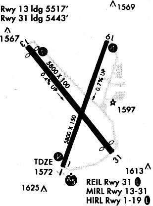
Runway Summary
| Runways: | 02/20 14/32 |
| Longest Runway: | 14/32 is 5806 ft (1770 m) long |
| Runways with an Instrument Approach: | 02 |
OFK Airport Runway Details
| Runway 02/20 | 5801 ft x 100 ft (1768 m x 30 m) | |
| Runway Length Source: | 3RD PARTY SURVEY as of 11/07/2019 | |
| Surface: | Asphalt - Good condition - Porous friction course | |
| Runway Edge Lights: | High Intensity | |
Runway Weight Bearing Capacity (in thousands of pounds) |
||
| Single Wheel Landing Gear: | 60.0 | |
| Dual Wheel Landing Gear: | 192.0 | |
| Dual Tandem Wheel Landing Gear: | 360.0 | |
Runway 02 |
Runway 20 |
|
Elevation: |
1572.6 | 1530.5 |
Latitude: |
41-58-39.3889N | 41-59-33.4241N |
Longitude: |
097-26-15.0137W | 097-25-49.5008W |
|
Runway True Alignment: |
019 | 199 |
ILS Type: |
ILS | |
Glide Path Angle: |
3.0 degrees | 3.0 degrees |
Traffic Pattern: |
Left | Left |
Runway Markings Type: |
Precision Instrument | Nonprecision Instrument |
Runway Markings Condition: |
Good | Good |
Object at End: |
FENCE | TREE |
Object Height: |
27 | 73 |
Distance from End: |
1470 | 1371 |
Object Centerline Offset: |
659 ft. right of centerline | |
Visual Glide Slope Indicators: |
4-Light PAPI On Left Side Of Runway | 4-Light PAPI On Left Side Of Runway |
Approach Light System: |
1,400 Foot Medium Intensity Approach Lighting System With Runway Alignment Indicator Lights | |
REIL: |
Yes | |
Threshold Crossing Height: |
49 | 40 |
Threshold Elevation: |
1532.0 | |
Displaced Threshold: |
297 | |
Threshold Latitude: |
41-59-30.6565N | |
Threshold Longitude: |
097-25-50.8074W |
| Runway 14/32 | 5806 ft x 100 ft (1770 m x 30 m) | |
| Runway Length Source: | 3RD PARTY SURVEY as of 11/07/2019 | |
| Surface: | Asphalt - Good condition - Porous friction course | |
| Runway Edge Lights: | Medium Intensity | |
Runway Weight Bearing Capacity (in thousands of pounds) |
||
| Single Wheel Landing Gear: | 75.0 | |
| Dual Wheel Landing Gear: | 192.0 | |
| Dual Tandem Wheel Landing Gear: | 400.0 | |
Runway 14 |
Runway 32 |
|
Elevation: |
1542.8 | 1564.1 |
Latitude: |
41-59-31.4825N | 41-58-46.3287N |
Longitude: |
097-26-34.2603W | 097-25-46.8566W |
|
Runway True Alignment: |
142 | 322 |
Glide Path Angle: |
3.0 degrees | 3.5 degrees |
Traffic Pattern: |
Left | Left |
Runway Markings Type: |
Nonprecision Instrument | Nonprecision Instrument |
Runway Markings Condition: |
Good | Good |
Object at End: |
RR | TREE |
Object Height: |
28 | 41 |
Distance from End: |
898 | 1069 |
Object Centerline Offset: |
659 ft. right of centerline | |
Visual Glide Slope Indicators: |
4-Light PAPI On Left Side Of Runway | 4-Light PAPI On Left Side Of Runway |
REIL: |
Yes | |
Threshold Crossing Height: |
40 | 49 |
Threshold Elevation: |
1543.0 | 1559.9 |
Displaced Threshold: |
287 | 360 |
Threshold Latitude: |
41-59-29.2512N | 41-58-49.1276N |
Threshold Longitude: |
097-26-31.9179W | 097-25-49.7949W |
Declared Distances |
||
Take Off Run Avbl. (TORA): |
5443 | 5517 |
Take Off Distance Avbl. (TODA): |
5800 | 5800 |
Actual Stop Dist. Avbl. (ASDA): |
5443 | 5517 |
Landing Dist. Avbl. (LDA): |
5160 | 5160 |
Services
Airframe Repair: |
Minor |
Powerplant Repair: |
Minor |
Bottled Oxygen: |
None |
Bulk Oxygen: |
None |
Fuel Available: |
100LL, Jet A+ |
Landing Fees: |
No |
Parking: |
Hangars and tiedowns available |
Maps & Diagrams
OFK Sectional
Flight Planning
at skyvector.com
at skyvector.com