Location
Latitude: |
40-53-47.0990N (40.896416) |
Longitude: |
097-37-26.6608W (-97.624072) |
Elevation: |
1669.7 feet MSL (509 m MSL) |
Magnetic Variation: |
3.3 E (as of April 2024 from WMM2020 model) |
Time Zone: |
UTC -6.0 (Standard Time) UTC -5.0 (Daylight Savings Time) |
From City: |
01 N.M. NW of York, Nebraska |
Found On: |
Omaha Chart |
FAA Region: |
ACE |
Contacts
Manager: |
Publicly owned: |
| RANDY HALL 1112 HWY 34 YORK, NE 68467-3512 402-366-5876 |
CITY OF YORK PO BOX 276 YORK, NE 68467-0276 402-363-2600 |
Operations
Airport Status: |
Operational |
Facility Use: |
Public |
Type: |
Airport |
Activation Date: |
06/1985 |
Control tower: |
No |
Attendance (Months/Days/Hours): |
Months/Days/Hours ALL/ALL/0700-1700 |
Boundary ARTCC: |
ZMP (Minneapolis) |
Responsible ARTCC: |
ZMP (Minneapolis) |
Lighting Schedule: |
SEE RMK |
Segmented Circle Indicator: |
Yes |
Traffic Pattern Altitude (MSL): |
2670 feet (814 m) |
NOTAMs Facility: |
JYR |
NOTAM-D Service: |
Yes |
Based Aircraft
| Single Engine: | 24 |
| Multi Engine: | 1 |
| Gliders: | 2 |
Annual Operations (as of 08/02/2023)
| Total Operations: | 10475 | |
| Air Taxi: | 300 | 2.9% |
| GA Local: | 6200 | 59.2% |
| GA Itinerant: | 3950 | 37.7% |
| Military Aircraft: | 25 | 0.2% |
Communications
| CTAF: | 122.800 |
| Unicom: | 122.800 |
| AWOS-3: | 124.175 (402-362-3785) |
- APCH/DEP SVC PRVDD BY MINNEAPOLIS ARTCC ON FREQ 119.4/278.8 (HASTINGS RCAG).
Fixed Based Operators (FBOs) & Fuel
(Click on a business for detail)
Please help us keep this information up to date. This is a FREE SERVICE just like everything else on Airport Guide! If you see that a business needs to be added, modified, or deleted please fill out our Update Form.
To add, modify, or delete a business click here.
Please help us keep this information up to date. This is a FREE SERVICE just like everything else on Airport Guide! If you see that a business needs to be added, modified, or deleted please fill out our Update Form.
Area Code: 402 |
| Business Name | Frequency | Phone | Fuel Grade |
|---|---|---|---|
| Sunrise Aviation
Update FBO info |
Unicom 122.8 | 362-5873 | 100LL, Jet A |
| York Municipal Airport
Update FBO info |
Unicom 122.8 | 363-2660 | 100LL, Jet A |
Flight Service Stations
| Primary | Alternate | |
| FSS on Field: | ||
| FSS Name (ID): | Columbus(OLU) | |
| Frequency: | ||
| Toll Free Phone: | 1-800-WX-BRIEF |
Instrument Procedures / Charts
FAA Terminal Procedures valid from 0901Z 03/21/24 to 0901Z 04/18/24.
There are various types of charts available for an airport. They are listed in the Page Type column. Here is a legend for those types:
APD - Airport Diagram
DP - Departure Procedure Charts
HOT - Hot Spots
IAP - Instrument Approach Procedure Charts
MIN - Minimums
STAR - Standard Terminal Arrival Charts
| Page Type | Page Name | Volume | Action Since Last Cycle |
|---|---|---|---|
| IAP | NDB RWY 17 | NC-2 | |
| IAP | NDB RWY 35 | NC-2 | |
| IAP | RNAV (GPS) RWY 17 | NC-2 | |
| IAP | RNAV (GPS) RWY 35 | NC-2 | |
| MIN | ALTERNATE MINIMUMS | NC-2 | |
| MIN | TAKEOFF MINIMUMS | NC-2 |
Terminal Procedures are only available for airports in several countries with more being added all the time. If you are looking for a specific country's charts, please send an email to support(at)airportguide.com stating the country name. This will be used to prioritize the implementation.
Navigation Aids (Navaids) near KJYR
| Dist (NM) | ID | Morse Code | Name | Type | Freq | True Hdg | Mag Hdg |
|---|---|---|---|---|---|---|---|
| 0.3 | JYR | . _ _ _ _ . _ _ . _ . | York | NDB | 257 | 78 | 75 |
| 18.6 | FMZ | . . _ . _ _ _ _ . . | Beklof | NDB | 392 | 172 | 169 |
| 23.3 | SWT | . . . . _ _ _ | Seward | NDB | 269 | 95 | 92 |
| 31.4 | GR | _ _ . . _ . | Sancy | NDB | 380 | 267 | 264 |
| 31.7 | GRI | _ _ . . _ . . . | Grand Island | VOR-DME | 112.00 | 279 | 276 |
| 35.6 | OLU | _ _ _ . _ . . . . _ | Columbus | VOR-DME | 111.80 | 20 | 17 |
| 37.6 | PLT | . _ _ . . _ . . _ | Platte Center | NDB | 407 | 16 | 13 |
| 40.0 | LNK | . _ . . _ . _ . _ | Lincoln | VORTAC | 116.10 | 87 | 84 |
| 40.1 | LN | . _ . . _ . | Potts | NDB | 385 | 102 | 99 |
| 40.6 | HSI | . . . . . . . . . | Hastings | VOR-DME | 108.80 | 244 | 240 |
| 40.8 | PSS | . _ _ . . . . . . . | Prosser | NDB | 338 | 252 | 248 |
| 43.7 | OBH | _ _ _ _ . . . . . . . | Wolbach | DME | 112 | 311 | 307 |
| 44.8 | HJH | . . . . . _ _ _ . . . . | Hebron | NDB | 323 | 177 | 174 |
| 48.0 | FBY | . . _ . _ . . . _ . _ _ | Fairbury | NDB | 293 | 154 | 151 |
| 50.8 | AHQ | . _ . . . . _ _ . _ | Wahoo | NDB | 400 | 65 | 62 |
| 53.3 | BIE | _ . . . . . . | Beatrice | VOR | 110.60 | 131 | 128 |
| 53.6 | BVN | _ . . . . . . _ _ . | Alaby | NDB | 332 | 339 | 336 |
| 59.8 | OF | _ _ _ . . _ . | Carsy | NDB | 510 | 6 | 3 |
| 61.8 | SCB | . . . _ . _ . _ . . . | Scribner | VOR-DME | 111.00 | 46 | 43 |
| 63.5 | EAR | . . _ . _ . | Kearney | VOR | 111.20 | 261 | 257 |
Nearby Airports with Fuel
Notices to Airmen (NOTAMS)
Remarks
| A110-1 | RY 35 DESIGNATED AS CALM WIND RY. |
| A110-2 | FOR CD CTC MINNEAPOLIS ARTCC AT 651-463-5588. |
| A14 | RANDY HALL AIRPORT OPS MANAGER |
| A17 | FOR SVC AFTER HRS CALL (402) 366-5876 |
| A30-05/23 | NOT PLOWED WINTER MONTHS. |
| A52-05 | RWY 05 CNTR PIVOT ROTATES INTO APCH DURING IRRIGATION SEASON. |
| A57-17 | RWY 35 APCH SLOPE 50:1 DUE TO 12 FT ROAD 1020 FT FROM DSPLCD THLD. |
| A81-APT | ACTVT MIRL RY 17/35; PAPI RYS 17 & 35; REIL RYS 17 & 35 - CTAF. |
| E111 | DETERMINATION PENDING. |
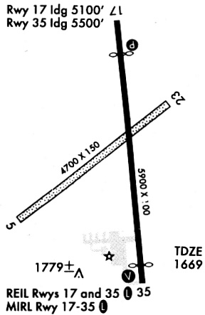
Runways
Runway Summary
| Runways: | 05/23 17/35 |
| Longest Runway: | 17/35 is 5898 ft (1798 m) long |
| Runways with an Instrument Approach: |
KJYR Airport Runway Details
| Runway 05/23 | 4500 ft x 150 ft (1372 m x 46 m) | |
| Runway Length Source: | REGION as of 05/10/2013 | |
| Surface: | Turf - Good condition - No special surface treatment | |
Runway 05 |
Runway 23 |
|
Elevation: |
1665.0 | 1664.0 |
Latitude: |
40-53-32.4000N | 40-53-58.6100N |
Longitude: |
097-37-56.4100W | 097-37-09.0800W |
|
Runway True Alignment: |
054 | 234 |
Glide Path Angle: |
0.0 degrees | 0.0 degrees |
Object at End: |
POLE | PLINE |
Object Height: |
50 | 40 |
Distance from End: |
1004 | 829 |
Object Centerline Offset: |
219 ft. left of centerline | 113 ft. right of centerline |
| Runway 17/35 | 5898 ft x 100 ft (1798 m x 30 m) | |
| Runway Length Source: | 3RD PARTY SURVEY as of 10/09/2007 | |
| Surface: | Turf - Good condition - No special surface treatment | |
| Runway Edge Lights: | Medium Intensity | |
Runway Weight Bearing Capacity (in thousands of pounds) |
||
| Single Wheel Landing Gear: | 30.0 | |
| Dual Wheel Landing Gear: | 38.0 | |
Runway 17 |
Runway 35 |
|
Elevation: |
1664.9 | 1669.7 |
Latitude: |
40-54-17.3359N | 40-53-19.2945N |
Longitude: |
097-37-25.6026W | 097-37-18.4350W |
|
Runway True Alignment: |
175 | 355 |
Glide Path Angle: |
3.0 degrees | 3.0 degrees |
Runway Markings Type: |
Nonprecision Instrument | Nonprecision Instrument |
Runway Markings Condition: |
Good | Good |
Object at End: |
POLE | ROAD |
Object Height: |
46 | 12 |
Distance from End: |
1437 | 620 |
Object Centerline Offset: |
219 ft. left of centerline | 113 ft. right of centerline |
Visual Glide Slope Indicators: |
2-Light PAPI On Left Side Of Runway | 2-Light PAPI On Left Side Of Runway |
REIL: |
Yes | Yes |
Threshold Crossing Height: |
40 | 40 |
Threshold Elevation: |
1667.7 | |
Displaced Threshold: |
400 | |
Threshold Latitude: |
40-53-23.2311N | |
Threshold Longitude: |
097-37-18.9210W | |
Declared Distances |
||
Take Off Run Avbl. (TORA): |
5900 | 5900 |
Take Off Distance Avbl. (TODA): |
5900 | 5900 |
Actual Stop Dist. Avbl. (ASDA): |
5500 | 5900 |
Landing Dist. Avbl. (LDA): |
5900 | 5500 |
Services
Airframe Repair: |
Major |
Powerplant Repair: |
Major |
Bottled Oxygen: |
High Pressure / Low Pressure |
Bulk Oxygen: |
High Pressure / Low Pressure |
Fuel Available: |
100LL, Jet A-1+ |
Landing Fees: |
No |
Parking: |
Hangars and tiedowns available |
Maps & Diagrams
KJYR Sectional
Flight Planning
at skyvector.com
at skyvector.com