Location
Latitude: |
42-45-55.0000N (42.765278) |
Longitude: |
096-56-03.3000W (-96.93425) |
Elevation: |
1146.7 feet MSL (350 m MSL) |
Magnetic Variation: |
2.8 E (as of May 2024 from WMM2020 model) |
Time Zone: |
UTC -6.0 (Standard Time) UTC -5.0 (Daylight Savings Time) |
From City: |
01 N.M. S of Vermillion, South Dakota |
Found On: |
Omaha Chart |
FAA Region: |
AGL |
Contacts
Manager: |
Publicly owned: |
| DENNY MARTENS 25 CENTER ST. VERMILLION, SD 57069 605-677-8159 |
CITY OF VERMILLION 25 CENTER ST. VERMILLION, SD 57069 (605) 677-7050 |
Operations
Airport Status: |
Operational |
Facility Use: |
Public |
Type: |
Airport |
Activation Date: |
07/1957 |
Control tower: |
No |
Attendance (Months/Days/Hours): |
Months/Days/Hours ALL/MON-FRI/0800-1700 |
Boundary ARTCC: |
ZMP (Minneapolis) |
Responsible ARTCC: |
ZMP (Minneapolis) |
Lighting Schedule: |
SEE RMK |
Segmented Circle Indicator: |
No |
Traffic Pattern Altitude (MSL): |
2147 feet (654 m) |
NOTAMs Facility: |
HON |
NOTAM-D Service: |
Yes |
International Airport of Entry: |
No |
Customs Landing Rights: |
No |
Military Landing Rights: |
Yes |
Civil/Military Joint Use: |
No |
Based Aircraft
| Single Engine: | 11 |
| Multi Engine: | 2 |
Annual Operations (as of 04/11/2023)
| Total Operations: | 4098 | |
| Air Taxi: | 18 | 0.4% |
| GA Local: | 3500 | 85.4% |
| GA Itinerant: | 580 | 14.2% |
Communications
| CTAF: | 122.800 |
| Unicom: | 122.800 |
| Approach: | SIOUX CITY 124.6 124.6 MINNEAPOLIS ARTCC |
| Departure: | SIOUX CITY 124.6 124.6 MINNEAPOLIS ARTCC |
- APCH/DEP SVC PRVDD BY MINNEAPOLIS ARTCC ON FREQS 125.025/235.625 (SIOUX CITY RCAG) WHEN SIOUX CITY APCH CTL CLSD.
- COMMUNICATIONS PRVDD BY HURON RADIO ON FREQ 122.4 (YANKTON RCO).
Fixed Based Operators (FBOs) & Fuel
(Click on a business for detail)
Please help us keep this information up to date. This is a FREE SERVICE just like everything else on Airport Guide! If you see that a business needs to be added, modified, or deleted please fill out our Update Form.
To add, modify, or delete a business click here.
Please help us keep this information up to date. This is a FREE SERVICE just like everything else on Airport Guide! If you see that a business needs to be added, modified, or deleted please fill out our Update Form.
Area Code: 605 |
| Business Name | Frequency | Phone | Fuel Grade |
|---|---|---|---|
| Midwest Flying Service of SD
Update FBO info |
624-3100 | 80, 100LL |
Flight Service Stations
| Primary | Alternate | |
| FSS on Field: | N | |
| FSS Name (ID): | Huron(HON) | |
| Frequency: | ||
| Toll Free Phone: | 1-800-WX-BRIEF |
Instrument Procedures / Charts
FAA Terminal Procedures valid from 0901Z 05/16/24 to 0901Z 06/13/24.
There are various types of charts available for an airport. They are listed in the Page Type column. Here is a legend for those types:
APD - Airport Diagram
DP - Departure Procedure Charts
HOT - Hot Spots
IAP - Instrument Approach Procedure Charts
MIN - Minimums
STAR - Standard Terminal Arrival Charts
| Page Type | Page Name | Volume | Action Since Last Cycle |
|---|---|---|---|
| IAP | RNAV (GPS) RWY 12 | NC-1 | |
| IAP | RNAV (GPS) RWY 30 | NC-1 | |
| MIN | TAKEOFF MINIMUMS | NC-1 |
Terminal Procedures are only available for airports in several countries with more being added all the time. If you are looking for a specific country's charts, please send an email to support(at)airportguide.com stating the country name. This will be used to prioritize the implementation.
Navigation Aids (Navaids) near KVMR
| Dist (NM) | ID | Morse Code | Name | Type | Freq | True Hdg | Mag Hdg |
|---|---|---|---|---|---|---|---|
| 16.9 | YK | _ . _ _ _ . _ | Cagur | NDB | 347 | 286 | 283 |
| 21.9 | YKN | _ . _ _ _ . _ _ . | Yankton | DME | 111.4 | 295 | 292 |
| 27.7 | OI | _ _ _ . . | Tommi | NDB | 305 | 131 | 128 |
| 32.3 | GAK | _ _ . . _ _ . _ | Sioux Gateway | NDB | 233 | 131 | 128 |
| 37.0 | SUX | . . . . . _ _ . . _ | Sioux City | TACAN | 116.50 | 132 | 129 |
| 38.7 | SU | . . . . . _ | Salix | NDB | 414 | 132 | 129 |
| 39.4 | SOY | . . . _ _ _ _ . _ _ | Sioux Center | NDB | 368 | 55 | 52 |
| 40.7 | ORC | _ _ _ . _ . _ . _ . | Orange City | NDB | 521 | 70 | 68 |
| 44.0 | FS | . . _ . . . . | Rokky | NDB | 245 | 5 | 2 |
| 51.6 | OFK | _ _ _ . . _ . _ . _ | Norfolk | VOR-DME | 109.60 | 205 | 202 |
| 53.5 | FSD | . . _ . . . . _ . . | Sioux Falls | VORTAC | 115.00 | 7 | 4 |
| 55.3 | SHL | . . . . . . . . _ . . | Sheldon | NDB | 338 | 60 | 58 |
| 58.0 | OF | _ _ _ . . _ . | Carsy | NDB | 510 | 204 | 201 |
| 61.4 | MEY | _ _ . _ . _ _ | Mapleton | NDB | 335 | 124 | 122 |
| 62.3 | AGZ | . _ _ _ . _ _ . . | Wagner | NDB | 392 | 287 | 284 |
| 63.2 | ISB | . . . . . _ . . . | Sibley | NDB | 269 | 54 | 52 |
| 69.0 | TQE | _ _ _ . _ . | Tekamah | VOR | 108.40 | 150 | 147 |
| 70.9 | SCB | . . . _ . _ . _ . . . | Scribner | VOR-DME | 111.00 | 168 | 165 |
| 75.2 | MDS | _ _ _ . . . . . | Wentworth | NDB | 400 | 354 | 351 |
| 75.2 | SLB | . . . . _ . . _ . . . | Storm Lake | NDB | 434 | 96 | 94 |
Nearby Airports with Fuel
Notices to Airmen (NOTAMS)
Remarks
| A110-1 | WATERFOWL AND BIRDS ON AND INVOF ARPT. |
| A110-2 | FOR CD CTC SIOUX CITY APCH AT 712-293-2482. WHEN SIOUX CITY APCH CLSD, FOR CD CTC MINNEAPOLIS ARTCC AT 651-463-5588. |
| A70-FUEL-A | FUEL AVBL 24 HRS WITH CREDIT CARD. |
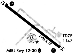
| A81-APT | ACTVT PAPI RWY 12 & 30; MIRL RWY 12/30 - CTAF. |
| A82 | AUTOMATED UNICOM. |
Runways
Runway Summary
| Runways: | 12/30 |
| Longest Runway: | 12/30 is 4105 ft (1251 m) long |
| Runways with an Instrument Approach: |
KVMR Airport Runway Details
| Runway 12/30 | 4105 ft x 75 ft (1251 m x 23 m) | |
| Runway Length Source: | 3RD PARTY SURVEY as of 08/20/2011 | |
| Surface: | Concrete - Excellent condition - No special surface treatment | |
| Runway Edge Lights: | Medium Intensity | |
Runway Weight Bearing Capacity (in thousands of pounds) |
||
| Single Wheel Landing Gear: | 12.0 | |
Runway 12 |
Runway 30 |
|
Elevation: |
1144.9 | 1145.2 |
Latitude: |
42-46-06.9521N | 42-45-43.1138N |
Longitude: |
096-56-25.5782W | 096-55-41.0748W |
|
Runway True Alignment: |
126 | 306 |
Glide Path Angle: |
3.0 degrees | 3.0 degrees |
Traffic Pattern: |
Right | Left |
Runway Markings Type: |
Nonprecision Instrument | Nonprecision Instrument |
Runway Markings Condition: |
Fair | Fair |
Object at End: |
TREES | |
Object Height: |
70 | |
Distance from End: |
1900 | |
Object Centerline Offset: |
0 ft. left and right of centerline | |
Visual Glide Slope Indicators: |
2-Light PAPI On Left Side Of Runway | 2-Light PAPI On Left Side Of Runway |
REIL: |
No | No |
Touchdown Lights: |
No | No |
Centerline Lights: |
No | No |
Threshold Crossing Height: |
38 | 38 |
Services
Airframe Repair: |
Major |
Powerplant Repair: |
Major |
Bottled Oxygen: |
None |
Bulk Oxygen: |
None |
Fuel Available: |
100, Jet A |
Landing Fees: |
No |
Parking: |
Hangars and tiedowns available |
Maps & Diagrams
KVMR Sectional
Flight Planning
at skyvector.com
at skyvector.com