Location
Latitude: |
42-14-29.7807N (42.241606) |
Longitude: |
096-58-56.1756W (-96.982271) |
Elevation: |
1431.7 feet MSL (436 m MSL) |
Magnetic Variation: |
2.8 E (as of April 2024 from WMM2020 model) |
Time Zone: |
UTC -6.0 (Standard Time) UTC -5.0 (Daylight Savings Time) |
From City: |
02 N.M. E of Wayne, Nebraska |
Found On: |
Omaha Chart |
FAA Region: |
ACE |
Contacts
Manager: |
Publicly owned: |
| TOM BECKER 56395 881 ROAD HARTINGTON, NE 68739-0188 402-841-0659 |
WAYNE AIRPORT AUTHORITY PO BOX 8 WAYNE, NE 68787-0008 402-375-1733 |
Operations
Airport Status: |
Operational |
Facility Use: |
Public |
Type: |
Airport |
Activation Date: |
03/1941 |
Control tower: |
No |
Attendance (Months/Days/Hours): |
Months/Days/Hours ALL/ALL/DAWN - DUSK |
Boundary ARTCC: |
ZMP (Minneapolis) |
Responsible ARTCC: |
ZMP (Minneapolis) |
Lighting Schedule: |
SEE RMK |
Segmented Circle Indicator: |
Yes |
Traffic Pattern Altitude (MSL): |
2432 feet (741 m) |
NOTAMs Facility: |
LCG |
NOTAM-D Service: |
Yes |
International Airport of Entry: |
No |
Customs Landing Rights: |
No |
Military Landing Rights: |
Yes |
Civil/Military Joint Use: |
No |
Based Aircraft
| Single Engine: | 12 |
| Multi Engine: | 2 |
Annual Operations (as of 07/14/2022)
| Total Operations: | 7980 | |
| GA Local: | 6880 | 86.2% |
| GA Itinerant: | 1100 | 13.8% |
Communications
| CTAF: | 122.800 |
| Unicom: | 122.800 |
| Approach: | SIOUX CITY 124.6 124.6 MINNEAPOLIS ARTCC |
| Departure: | SIOUX CITY 124.6 124.6 MINNEAPOLIS ARTCC |
| AWOS-3: | 120.125 (402-375-0111) |
- APCH/DEP SVC PRVDD BY MINNEAPOLIS ARTCC ON FREQS 125.025/235.625 (SIOUX CITY RCAG) WHEN SIOUX CITY APCH CTL CLSD.
Fixed Based Operators (FBOs) & Fuel
(Click on a business for detail)
Please help us keep this information up to date. This is a FREE SERVICE just like everything else on Airport Guide! If you see that a business needs to be added, modified, or deleted please fill out our Update Form.
To add, modify, or delete a business click here.
Please help us keep this information up to date. This is a FREE SERVICE just like everything else on Airport Guide! If you see that a business needs to be added, modified, or deleted please fill out our Update Form.
Area Code: 402 |
| Business Name | Frequency | Phone | Fuel Grade |
|---|---|---|---|
| Midwest Flying Service
Update FBO info |
Unicom 122.8 | 375-4664 | 100LL |
Flight Service Stations
| Primary | Alternate | |
| FSS on Field: | N | |
| FSS Name (ID): | Columbus(OLU) | |
| Frequency: | ||
| Toll Free Phone: | 1-800-WX-BRIEF |
Instrument Procedures / Charts
FAA Terminal Procedures valid from 0901Z 03/21/24 to 0901Z 04/18/24.
There are various types of charts available for an airport. They are listed in the Page Type column. Here is a legend for those types:
APD - Airport Diagram
DP - Departure Procedure Charts
HOT - Hot Spots
IAP - Instrument Approach Procedure Charts
MIN - Minimums
STAR - Standard Terminal Arrival Charts
| Page Type | Page Name | Volume | Action Since Last Cycle |
|---|---|---|---|
| IAP | RNAV (GPS) RWY 18 | NC-2 | Changed |
| IAP | RNAV (GPS) RWY 23 | NC-2 | |
| IAP | RNAV (GPS) RWY 36 | NC-2 | Changed |
| MIN | ALTERNATE MINIMUMS | NC-2 | Changed |
| MIN | TAKEOFF MINIMUMS | NC-2 |
Terminal Procedures are only available for airports in several countries with more being added all the time. If you are looking for a specific country's charts, please send an email to support(at)airportguide.com stating the country name. This will be used to prioritize the implementation.
Navigation Aids (Navaids) near KLCG
| Dist (NM) | ID | Morse Code | Name | Type | Freq | True Hdg | Mag Hdg |
|---|---|---|---|---|---|---|---|
| 25.2 | OFK | _ _ _ . . _ . _ . _ | Norfolk | VOR-DME | 109.60 | 233 | 230 |
| 26.5 | OI | _ _ _ . . | Tommi | NDB | 305 | 60 | 57 |
| 28.3 | GAK | _ _ . . _ _ . _ | Sioux Gateway | NDB | 233 | 69 | 66 |
| 29.9 | SUX | . . . . . _ _ . . _ | Sioux City | TACAN | 116.50 | 77 | 74 |
| 30.7 | OF | _ _ _ . . _ . | Carsy | NDB | 510 | 226 | 223 |
| 31.1 | SU | . . . . . _ | Salix | NDB | 414 | 80 | 77 |
| 38.8 | YK | _ . _ _ _ . _ | Cagur | NDB | 347 | 338 | 335 |
| 41.3 | SCB | . . . _ . _ . _ . . . | Scribner | VOR-DME | 111.00 | 157 | 154 |
| 44.3 | YKN | _ . _ _ _ . _ _ . | Yankton | DME | 111.4 | 336 | 333 |
| 46.0 | TQE | _ _ _ . _ . | Tekamah | VOR | 108.40 | 128 | 125 |
| 48.1 | PLT | . _ _ . . _ . . _ | Platte Center | NDB | 407 | 201 | 198 |
| 50.1 | OLU | _ _ _ . _ . . . . _ | Columbus | VOR-DME | 111.80 | 198 | 195 |
| 52.9 | MEY | _ _ . _ . _ _ | Mapleton | NDB | 335 | 93 | 91 |
| 56.8 | BVN | _ . . . . . . _ _ . | Alaby | NDB | 332 | 237 | 234 |
| 60.6 | ORC | _ _ _ . _ . _ . _ . | Orange City | NDB | 521 | 41 | 39 |
| 62.6 | AHQ | . _ . . . . _ _ . _ | Wahoo | NDB | 400 | 163 | 160 |
| 63.9 | SOY | . . . _ _ _ _ . _ _ | Sioux Center | NDB | 368 | 32 | 29 |
| 69.7 | OM | _ _ _ _ _ | Gerfi | NDB | 320 | 138 | 136 |
| 73.0 | DNS | _ . . _ . . . . | Denison | NDB | 350 | 101 | 99 |
| 73.9 | MLE | _ _ . _ . . . | Millard | NDB | 371 | 147 | 145 |
Nearby Airports with Fuel
Notices to Airmen (NOTAMS)
Remarks
| A110-2 | DEER ON AND INVOF ARPT. |
| A110-4 | FOR CD CTC SIOUX CITY APCH AT 712-293-2482. WHEN SIOUX CITY APCH CLSD, FOR CD CTC MINNEAPOLIS ARTCC AT 651-463-5588. |
| A13 | TRAVIS MEYER , CHMN OF ARPT AUTHORITY, PHONE 402-375-1733. |
| A30-13/31 | RWY 31 END APCH CROSSES RWY 36 END APCH. NOT PLOWED WINTER MONTHS. |
| A30-18/36 | RWY 36 END APCH CROSSES RWY 31 END APCH. |
| A57-05 | RWY 05 CLNC SLOPE 25:1 DUE TO POLE 39 FT ABV; 1209 FT FM RWY END 66 FT L. |
| A57-18 | RWY 18 CLNC SLOPE 22:1 DUE TO ROAD 10 FT ABV; 423 FT FM RWY END 283 FT L/R. |
| A57-23 | RWY 23 CLNC SLOPE 39:1 DUE TO HILL 134 FT ABV; 5500 FT FM RWY END 850 FT L. |
| A75 | CALL FOR TSNT HNGR USE 402-841-0659. |
| A81-APT | PAPI RWY 18 & 36; MIRL RWYS 05/23, 18/36; OPR SS-2300. AFT 2300, ACTVT - CTAF. |
| E111 | PROVIDED APPROACH TO EACH RUNWY IS MAINTAINED FOR A MINIMUM 20:1 GLIDE SLOPE & THE TRANSITIONAL SURFACE BE MAINTAINED FOR A 7:1 SLOPE. |
Runways
Runway Summary
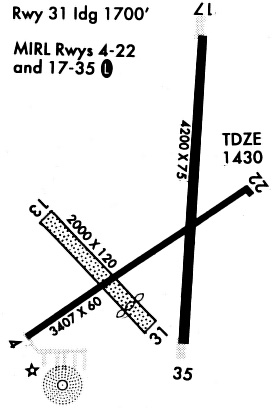
| Runways: | 05/23 13/31 18/36 |
| Longest Runway: | 18/36 is 4201 ft (1280 m) long |
| Runways with an Instrument Approach: |
KLCG Airport Runway Details
| Runway 05/23 | 3406 ft x 60 ft (1038 m x 18 m) | |
| Runway Length Source: | NGS as of 05/08/2009 | |
| Surface: | Concrete - Excellent condition - No special surface treatment | |
| Runway Edge Lights: | Medium Intensity | |
Runway Weight Bearing Capacity (in thousands of pounds) |
||
| Single Wheel Landing Gear: | 12.5 | |
Runway 05 |
Runway 23 |
|
Elevation: |
1430.7 | 1426.1 |
Latitude: |
42-14-15.0525N | 42-14-34.8002N |
Longitude: |
096-59-16.2812W | 096-58-39.6295W |
|
Runway True Alignment: |
054 | 234 |
Glide Path Angle: |
0.0 degrees | 0.0 degrees |
Traffic Pattern: |
Left | Left |
Runway Markings Type: |
Nonprecision Instrument | Nonprecision Instrument |
Runway Markings Condition: |
Good | Good |
| Runway 13/31 | 2070 ft x 120 ft (631 m x 37 m) | |
| Runway Length Source: | 3RD PARTY SURVEY as of 07/25/2008 | |
| Surface: | Concrete - Excellent condition - No special surface treatment | |
Runway 13 |
Runway 31 |
|
Elevation: |
1428.7 | 1426.3 |
Latitude: |
42-14-33.0897N | 42-14-18.7253N |
Longitude: |
096-59-17.4035W | 096-58-57.8228W |
|
Runway True Alignment: |
135 | 315 |
Glide Path Angle: |
0.0 degrees | 0.0 degrees |
Traffic Pattern: |
Left | Left |
| Runway 18/36 | 4201 ft x 75 ft (1280 m x 23 m) | |
| Runway Length Source: | NGS as of 05/08/2009 | |
| Surface: | Concrete - Excellent condition - No special surface treatment | |
| Runway Edge Lights: | Medium Intensity | |
Runway Weight Bearing Capacity (in thousands of pounds) |
||
| Single Wheel Landing Gear: | 30.0 | |
Runway 18 |
Runway 36 |
|
Elevation: |
1427.7 | 1431.7 |
Latitude: |
42-14-56.3648N | 42-14-14.8852N |
Longitude: |
096-58-48.3792W | 096-58-49.8145W |
|
Runway True Alignment: |
181 | 001 |
Glide Path Angle: |
3.0 degrees | 3.0 degrees |
Runway Markings Type: |
Nonprecision Instrument | Nonprecision Instrument |
Runway Markings Condition: |
Good | Good |
Visual Glide Slope Indicators: |
2-Light PAPI On Left Side Of Runway | 2-Light PAPI On Left Side Of Runway |
Threshold Crossing Height: |
40 | 40 |
Services
Airframe Repair: |
Major |
Powerplant Repair: |
Major |
Bottled Oxygen: |
High Pressure / Low Pressure |
Bulk Oxygen: |
High Pressure / Low Pressure |
Fuel Available: |
100LL, Jet A-1+ |
Landing Fees: |
No |
Parking: |
Hangars and tiedowns available |
Maps & Diagrams
KLCG Sectional
Flight Planning
at skyvector.com
at skyvector.com