Location
Latitude: |
34-49-45.0000N (34.829167) |
Longitude: |
077-36-43.7000W (-77.612139) |
Elevation: |
92.9 feet MSL (28 m MSL) |
Magnetic Variation: |
9.8 W (as of April 2024 from WMM2020 model) |
Time Zone: |
UTC -5.0 (Standard Time) UTC -4.0 (Daylight Savings Time) |
From City: |
10 N.M. NW of Jacksonville, North Carolina |
Found On: |
Charlotte Chart |
FAA Region: |
ASO |
Contacts
Manager: |
Publicly owned: |
| CHRISTOPHER WHITE 264 ELLIS AIRPORT RD RICHLANDS, NC 28574 910-324-1100 |
ONSLOW COUNTY 234 NW CORRIDOR BLVD JACKSONVILLE, NC 28540 910-347-4717 |
Operations
Airport Status: |
Operational |
Facility Use: |
Public |
Type: |
Airport |
Activation Date: |
02/1971 |
Control tower: |
Yes |
Attendance (Months/Days/Hours): |
Months/Days/Hours ALL/ALL/0500-2400 |
Boundary ARTCC: |
ZDC (Washington) |
Responsible ARTCC: |
ZDC (Washington) |
Lighting Schedule: |
SEE RMK |
Segmented Circle Indicator: |
Yes |
Traffic Pattern Altitude (MSL): |
1093 feet (333 m) |
NOTAMs Facility: |
OAJ |
NOTAM-D Service: |
Yes |
International Airport of Entry: |
No |
Customs Landing Rights: |
No |
Military Landing Rights: |
Yes |
Civil/Military Joint Use: |
No |
Aircraft Rescue and Firefighting: |
Class I ARFF Index: B Air Carrier Service: Scheduled Certification Date: 05/1973 |
Based Aircraft
| Single Engine: | 22 |
| Multi Engine: | 1 |
| GA Helicopters: | 3 |
Annual Operations (as of 07/31/2023)
| Total Operations: | 24191 | |
| Commercial: | 3720 | 15.4% |
| Air Taxi: | 2799 | 11.6% |
| GA Local: | 4110 | 17.0% |
| GA Itinerant: | 3890 | 16.1% |
| Military Aircraft: | 9672 | 40.0% |
Communications
| CTAF: | 132.650 |
| Unicom: | 122.950 |
| Tower: | ELLIS TOWER 132.65 Hrs: 0700-2200 |
| Clearance Del.: | 125.4 121.4 ;WHEN TWR CLSD 121.4 ;WHEN TWR CLSD 121.4 ;WHEN TWR CLSD 121.4 ;WHEN TWR CLSD |
| Ground: | 125.4 |
| Approach: | WILMINGTON WASHINGTON ARTCC |
| Departure: | WILMINGTON WASHINGTON ARTCC |
| ATIS: | 124.475 Hrs: 24 |
| AWOS-3PT: | (910-324-5233) |
- APCH/DEP SVC PRVDD BY WASHINGTON ARTCC ON FREQS 135.75/269.15 (WILMINGTON RCAG) WHEN WILMINGTON APCH CTL CLSD.
Fixed Based Operators (FBOs) & Fuel
(Click on a business for detail)
Please help us keep this information up to date. This is a FREE SERVICE just like everything else on Airport Guide! If you see that a business needs to be added, modified, or deleted please fill out our Update Form.
To add, modify, or delete a business click here.
Please help us keep this information up to date. This is a FREE SERVICE just like everything else on Airport Guide! If you see that a business needs to be added, modified, or deleted please fill out our Update Form.
Area Code: 910 |
| Business Name | Frequency | Phone | Fuel Grade |
|---|---|---|---|
| Tar Heel Aviation, Inc.
Update FBO info |
Unicom 123.0 | 324-2500 | 100LL, Jet A |
Flight Service Stations
| Primary | Alternate | |
| FSS on Field: | N | |
| FSS Name (ID): | Raleigh(RDU) | |
| Frequency: | ||
| Toll Free Phone: | 1-800-WX-BRIEF |
Instrument Procedures / Charts
FAA Terminal Procedures valid from 0901Z 03/21/24 to 0901Z 04/18/24.
There are various types of charts available for an airport. They are listed in the Page Type column. Here is a legend for those types:
APD - Airport Diagram
DP - Departure Procedure Charts
HOT - Hot Spots
IAP - Instrument Approach Procedure Charts
MIN - Minimums
STAR - Standard Terminal Arrival Charts
| Page Type | Page Name | Volume | Action Since Last Cycle |
|---|---|---|---|
| APD | AIRPORT DIAGRAM | SE-2 | |
| IAP | ILS OR LOC RWY 05 | SE-2 | |
| IAP | RNAV (GPS) RWY 05 | SE-2 | |
| IAP | RNAV (GPS) RWY 23 | SE-2 | |
| MIN | ALTERNATE MINIMUMS | SE-2 | |
| MIN | TAKEOFF MINIMUMS | SE-2 |
Terminal Procedures are only available for airports in several countries with more being added all the time. If you are looking for a specific country's charts, please send an email to support(at)airportguide.com stating the country name. This will be used to prioritize the implementation.
Navigation Aids (Navaids) near OAJ
| Dist (NM) | ID | Morse Code | Name | Type | Freq | True Hdg | Mag Hdg |
|---|---|---|---|---|---|---|---|
| 6.6 | OA | _ _ _ . _ | Ellas | NDB | 261 | 223 | 233 |
| 11.2 | NCA | _ . _ . _ . . _ | New River | TACAN | 115.40 | 130 | 140 |
| 17.5 | DIW | _ . . . . . _ _ | Dixon | NDB | 198 | 153 | 163 |
| 21.0 | DKA | _ . . _ . _ . _ | Kenan | NDB | 332 | 314 | 324 |
| 25.2 | IS | . . . . . | Stals | NDB | 276 | 350 | 360 |
| 28.6 | EW | . . _ _ | Katfi | NDB | 362 | 66 | 76 |
| 31.1 | GM | _ _ . _ _ | Wilze | NDB | 205 | 198 | 208 |
| 31.4 | ILM | . . . _ . . _ _ | Wilmington | VORTAC | 117.00 | 204 | 214 |
| 31.5 | EWN | . . _ _ _ . | New Bern | VOR-DME | 113.60 | 62 | 72 |
| 32.6 | ISO | . . . . . _ _ _ | Kinston | VORTAC | 117.50 | 4 | 14 |
| 35.1 | GSB | _ _ . . . . _ . . . | Seymour Johnson | TACAN | 116.50 | 329 | 339 |
| 36.6 | NKT | _ . _ . _ _ | Cherry Point | TACAN | 112.80 | 82 | 92 |
| 37.9 | CTZ | _ . _ . _ _ _ . . | Clinton | NDB | 412 | 283 | 293 |
| 40.3 | IL | . . . _ . . | Airli | NDB | 281 | 198 | 208 |
| 46.7 | CLB | _ . _ . . _ . . _ . . . | Carolina Beach | NDB | 216 | 201 | 211 |
| 47.2 | MRH | _ _ . _ . . . . . | Morehead | NDB | 269 | 96 | 106 |
| 47.8 | RNW | . _ . _ . . _ _ | Chocowinity | NDB | 388 | 31 | 41 |
| 48.1 | TGQ | _ _ _ . _ _ . _ | Elizabethtown | NDB | 398 | 248 | 258 |
| 49.9 | PGV | . _ _ . _ _ . . . . _ | Belvoir | FAN MARKER | 12 | 22 | |
| 54.0 | AQE | . _ _ _ . _ . | Alwood | NDB | 230 | 12 | 22 |
Nearby Airports with Fuel
Notices to Airmen (NOTAMS)
Remarks
| A110-1 | 180 DEG TURNS ON RWY 05/23 NA FOR ACFT 60000 LBS AND OVER. |
| A110-3 | CLSD TO ALL MIL ACFT OVER 17000 LBS FOR ACR RAMP OPNS EXCP 24 HR PPR. CALL AMGR 910-324-1100 OR 910-989-3168. |
| A110-5 | INDEX B ARFF COVERAGE PROVIDED DURING COMMERCIAL AIR TRC OPS. INDEX C AVAILABLE UPON REQ. |
| A110-6 | FIELD CONDITIONS NOT MONITORED 0000LCL-0500LCL DAILY. |
| A110-7 | FOR CD WHEN ATCT CLSD, CTC WILMINGTON APCH AT 910-815-4676, OR WHEN APCH CLSD CTC WASHINGTON ARTCC AT 703-771-3587. |
| A26 | CLSD TO UNSKED ACR OPNS WITH MORE THAN 30 PSGR SEATS EXCP PPR CALL AMGR 910-324-1100 OR 910-989-3168. |
| A70-FUEL-10 | 0LL FOR FUEL OTHER HRS CALL 910-347-8366. |
| A81-APT | ACTVT MALSR RWY 05; REIL RWY 23; PAPI RWY 05 & 23; HIRL RWY 05/23 - CTAF. |
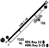
Runways
Runway Summary
| Runways: | 05/23 |
| Longest Runway: | 05/23 is 7100 ft (2164 m) long |
| Runways with an Instrument Approach: | 05 |
OAJ Airport Runway Details
| Runway 05/23 | 7100 ft x 150 ft (2164 m x 46 m) | |
| Runway Length Source: | 3RD PARTY SURVEY as of 01/30/2018 | |
| Surface: | Asphalt - Good condition - Saw-cut or plastic grooved | |
| Runway Pavement Class: | 51 /F/A/W/T | |
| Runway Edge Lights: | High Intensity | |
Runway Weight Bearing Capacity (in thousands of pounds) |
||
| Single Wheel Landing Gear: | 120.0 | |
| Dual Wheel Landing Gear: | 211.0 | |
| Dual Tandem Wheel Landing Gear: | 388.0 | |
Runway 05 |
Runway 23 |
|
Elevation: |
88.9 | 90.4 |
Latitude: |
34-49-19.8871N | 34-50-10.0619N |
Longitude: |
077-37-13.4680W | 077-36-13.8877W |
|
Runway True Alignment: |
044 | 224 |
ILS Type: |
ILS/DME | |
Glide Path Angle: |
3.0 degrees | 3.0 degrees |
Traffic Pattern: |
Left | Left |
Runway Markings Type: |
Precision Instrument | Precision Instrument |
Runway Markings Condition: |
Good | Good |
Visual Glide Slope Indicators: |
4-Light PAPI On Left Side Of Runway | 4-Light PAPI On Left Side Of Runway |
Approach Light System: |
1,400 Foot Medium Intensity Approach Lighting System With Runway Alignment Indicator Lights | |
REIL: |
Yes | |
Threshold Crossing Height: |
55 | 47 |
Services
Airframe Repair: |
Major |
Powerplant Repair: |
Major |
Bottled Oxygen: |
None |
Bulk Oxygen: |
None |
Fuel Available: |
100LL, Jet A-1+ |
Landing Fees: |
No |
Parking: |
Hangars and tiedowns available |
Maps & Diagrams
OAJ Sectional
Flight Planning
at skyvector.com
at skyvector.com